Menu

Les Village - Sea Communities Office

11
2

-8.130915, 115.370089

coral
4
74
Raincoat
Sunny
1
1
1
1
Raincoat
Measuring tape
Scissors
Melamine board
Sea Communities x Our Singapore Reefs
Sam Shu Qin
2
1
17
1
-11
2
45.40
45
9.00
-12.00
measured
1190.00
1
Cloth fragments
Fishing lines
Burlap bags
On
kilograms
I have debris data to report
3
Smooth (wavelets) for waves 0.1 - 0.5 meter high
1
84
7
9
m2
meters
coral reef
24
1
Indonesia
State\Province
Bali
City
Tejakula
Map Help


Dive Location

If you know your survey site coordinates, enter them manually in decimal degrees using WGS84 Map Datum. Use the minus sign for latitudes south of the equator and longitudes west of the Prime Meridian to 180 degrees.

If you do not know your survey site coordinates, click the “Map Location” tab to use the map to zoom into your survey site and drop the pin on the map to fall within your survey dive site in the water (not on land or the beach). Ensure you zoom in as much as possible to ensure data accuracy.

Entangled Help


Use the vertical tabs below to record any entangled animals you found of each type.

Marégrafo

10
33
10

38.69424013219, -9.417857967098

silt
1
1
2
1

38.69424013219, -9.417857967098

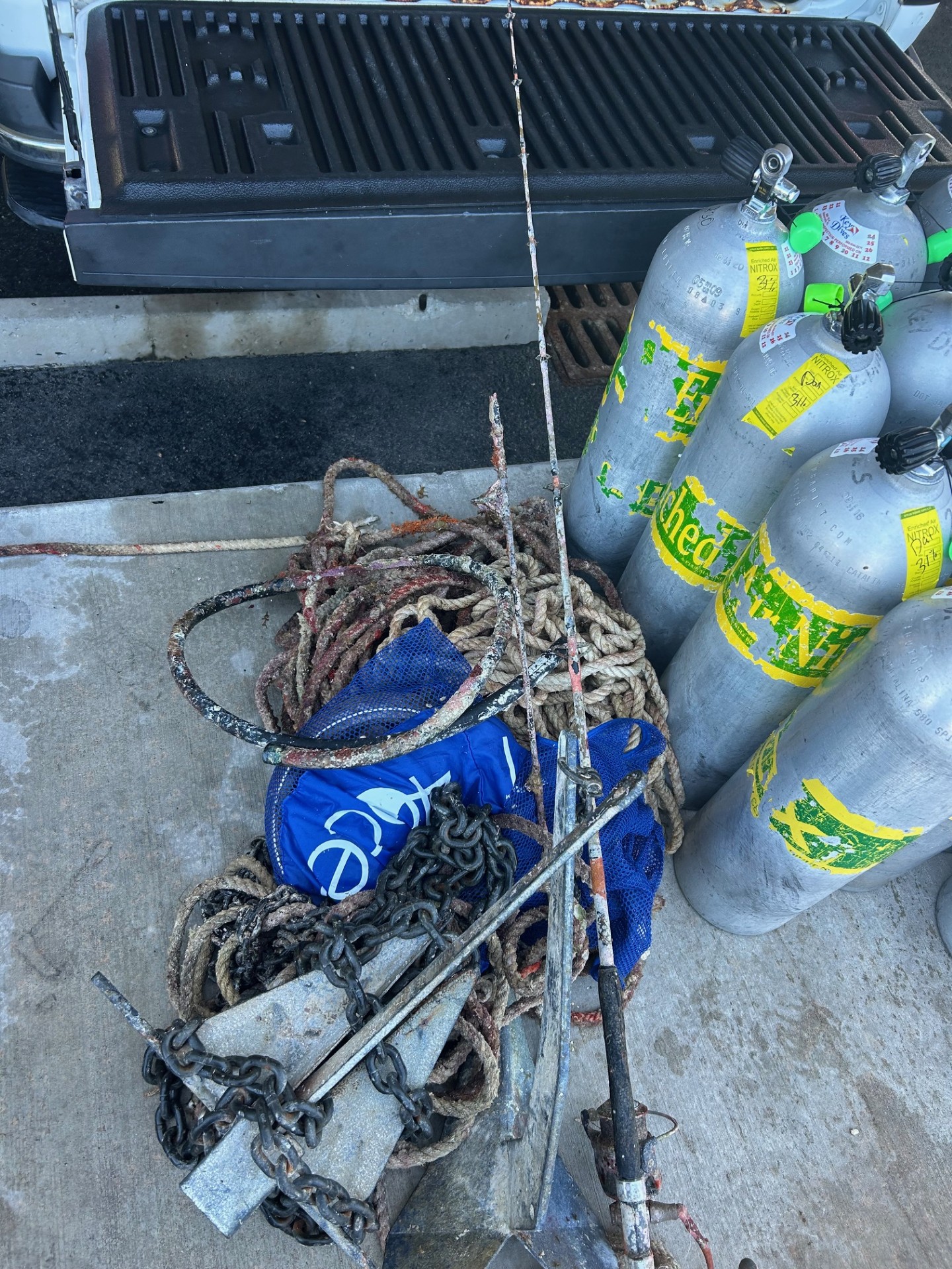
The 385kg were measured without counting the anchor and scooter.
2
2
1
1
1
1
4
61
1
Hoses
Boat Helm
Wallet
Anchor
Electric Scooter
Sanitary pad
Sponges
Fishing: traps & pots (plastic)
Rowing
Associação Juvenil Claro/Clube Naval de Cascais
Teresa Vale
5
1
3
1
4
1
3
13
20
1
18
18
1
2
1
385.00
75
5.00
3.00
3
measured
3458.82
2
3
2
On
kilograms
I have debris data to report
24
Calm (glassy to rippled) for waves 0 – 0.1 meter high
4
8
2
m2
1
meters
other
4
5
2
2
1
31
6
1
1
Portugal
City
Cascais
Map Help


Dive Location

If you know your survey site coordinates, enter them manually in decimal degrees using WGS84 Map Datum. Use the minus sign for latitudes south of the equator and longitudes west of the Prime Meridian to 180 degrees.

If you do not know your survey site coordinates, click the “Map Location” tab to use the map to zoom into your survey site and drop the pin on the map to fall within your survey dive site in the water (not on land or the beach). Ensure you zoom in as much as possible to ensure data accuracy.
Entangled Help


Use the vertical tabs below to record any entangled animals you found of each type.

New Caves Bay West Wall

1
0
0
0

36.541499962953, 29.032722322655

0
0
0
rock
0
0
0
0
0
Dropped by daily tourist boats
Fine
Seahorse dive centre
Mark Taylor
0
0
0
0
0
0
0
0
3
0
0
0
0
0
0
0
0
0
0
6
0
0
0
0
0
0
0
0
0
0
0
0
0
0
0
0
1.30
49
18.00
5.00
0
measured
0
0
8420.87
0
0
0
0
0
0
On
kilograms
0
I have debris data to report
0
0
0
Calm (glassy to rippled) for waves 0 – 0.1 meter high
0
0
0
0
0
0
0
m2
0
1
meters
rocky reef
0
0
0
0
0
0
0
0
0
0
0
0
0
0
0
0
0
0
0
0
0
0
0
0
0
0
0
0
0
Turkey
State\Province
Muğla
City
Fethiye
Map Help


Dive Location

If you know your survey site coordinates, enter them manually in decimal degrees using WGS84 Map Datum. Use the minus sign for latitudes south of the equator and longitudes west of the Prime Meridian to 180 degrees.

If you do not know your survey site coordinates, click the “Map Location” tab to use the map to zoom into your survey site and drop the pin on the map to fall within your survey dive site in the water (not on land or the beach). Ensure you zoom in as much as possible to ensure data accuracy.
Entangled Help


Use the vertical tabs below to record any entangled animals you found of each type.

Karacaören Island East Wall

0
0
0
1

36.540867164603, 29.061536868112

0
0
0
rock
0
0
0
5
0
Lost by fishermen
Fine
Seahorse Diving Centre
Mark Taylor
0
0
0
0
0
0
0
0
0
0
0
0
0
0
0
0
0
0
0
10
0
0
0
0
0
0
0
0
0
0
0
0
0
0
0
0
6.00
55
20.00
5.00
0
measured
0
69
3096.13
0
0
0
0
0
Fishing lines
0
On
kilograms
0
I have debris data to report
0
0
0
Smooth (wavelets) for waves 0.1 - 0.5 meter high
0
0
0
0
0
0
0
m2
0
0
meters
rocky reef
0
0
0
0
0
0
0
0
0
0
0
0
0
0
0
0
0
0
0
0
0
0
0
0
0
0
0
0
0
Turkey
State\Province
Muğla
City
Ölüdeniz
Map Help


Dive Location

If you know your survey site coordinates, enter them manually in decimal degrees using WGS84 Map Datum. Use the minus sign for latitudes south of the equator and longitudes west of the Prime Meridian to 180 degrees.

If you do not know your survey site coordinates, click the “Map Location” tab to use the map to zoom into your survey site and drop the pin on the map to fall within your survey dive site in the water (not on land or the beach). Ensure you zoom in as much as possible to ensure data accuracy.

Entangled Help


Use the vertical tabs below to record any entangled animals you found of each type.

Timba Timba

0
0
0
0

4.553887, 118.919781

0
0
0
coral
0
0
0
25
0
Went specifically for fishing line removal
No
Sunny
TRACC
Dharkshen
0
0
0
0
0
0
0
0
0
0
0
0
0
0
0
0
0
0
0
4
0
0
0
0
0
0
0
0
0
0
0
0
0
0
0
0
4.75
60
20.00
1.00
0
measured
0
0
0
6
23.66
0
0
0
0
0
Fishing line
Fishing hooks
Fishing weights
0
On
kilograms
0
I have debris data to report
0
0
0
Smooth (wavelets) for waves 0.1 - 0.5 meter high
0
0
0
0
0
0
0
m2
0
0
meters
coral reef
0
0
0
0
0
0
0
0
0
0
0
0
0
0
0
0
0
0
0
0
0
0
0
0
0
0
0
0
0
Malaysia
State\Province
Sabah
Map Help


Dive Location

If you know your survey site coordinates, enter them manually in decimal degrees using WGS84 Map Datum. Use the minus sign for latitudes south of the equator and longitudes west of the Prime Meridian to 180 degrees.

If you do not know your survey site coordinates, click the “Map Location” tab to use the map to zoom into your survey site and drop the pin on the map to fall within your survey dive site in the water (not on land or the beach). Ensure you zoom in as much as possible to ensure data accuracy.
Entangled Help


Use the vertical tabs below to record any entangled animals you found of each type.

Oval Reef Havelock

0
0
0
0

12.0361111, 93.007222222222

0
0
0
sand
0
0
0
1
0
Calm
Lacadives
Denzil Fernandes
0
0
0
0
0
0
0
0
0
0
0
0
1
0
0
0
0
1
0
2
0
0
0
0
0
0
1
0
0
0
0
0
0
0
0
0
1.00
45
12.00
3.00
0
estimated
0
0
0
1
835.66
0
0
0
0
0
0
On
kilograms
0
I have debris data to report
0
0
0
Calm (glassy to rippled) for waves 0 – 0.1 meter high
0
0
0
0
0
0
0
m2
0
0
meters
coral reef
0
0
1
0
0
0
0
0
0
0
0
0
0
0
0
0
0
0
0
0
0
0
0
0
0
0
0
0
0
India
State\Province
A&D
City
Havelock
Map Help


Dive Location

If you know your survey site coordinates, enter them manually in decimal degrees using WGS84 Map Datum. Use the minus sign for latitudes south of the equator and longitudes west of the Prime Meridian to 180 degrees.

If you do not know your survey site coordinates, click the “Map Location” tab to use the map to zoom into your survey site and drop the pin on the map to fall within your survey dive site in the water (not on land or the beach). Ensure you zoom in as much as possible to ensure data accuracy.
Entangled Help


Use the vertical tabs below to record any entangled animals you found of each type.

Peñon

0
0
0
0

18.254008028994, -68.779833

0
0
0
coral
0
0
0
0
0
Slow Dive - Casa Chihuahua
Julie
0
0
0
2
0
0
0
0
0
0
0
0
0
0
0
0
0
0
0
3
0
0
0
0
0
0
0
0
0
0
0
0
0
0
0
0
0.00
60
12.00
8.00
0
estimated
0
0
8252.62
0
0
0
0
0
0
On
kilograms
0
I have debris data to report
0
0
0
Slight for waves 0.5 -1.25 meter high
0
0
0
0
0
0
0
m2
0
0
meters
coral reef
0
0
0
0
0
0
0
0
0
0
0
0
0
0
0
0
0
0
0
0
0
0
0
0
0
0
0
0
0
Dominican Republic
State\Province
La Altagracia
City
Bayahibe
Map Help


Dive Location

If you know your survey site coordinates, enter them manually in decimal degrees using WGS84 Map Datum. Use the minus sign for latitudes south of the equator and longitudes west of the Prime Meridian to 180 degrees.

If you do not know your survey site coordinates, click the “Map Location” tab to use the map to zoom into your survey site and drop the pin on the map to fall within your survey dive site in the water (not on land or the beach). Ensure you zoom in as much as possible to ensure data accuracy.
Entangled Help


Use the vertical tabs below to record any entangled animals you found of each type.

Grand anse

31
5
14
1

12.024666127982, -61.761984912564

1
0
0
seagrass
0
4
0
2
0
Pre carnival clean up big clean up coming this Friday
Summer holiday
Sanitary napkins
Eco dive
Christine
1
0
0
6
0
0
0
0
1
0
0
1
0
2
2
0
0
4
0
2
2
6
2
5
2
1
5
1
2
1
0
1
2
0
0
0
10.00
45
4.00
1.00
0
estimated
0
0
8901.70
0
0
0
0
0
Food containers
Clothing
Plastics
0
On
kilograms
0
I have debris data to report
5
0
0
Calm (glassy to rippled) for waves 0 – 0.1 meter high
0
0
7
0
7
0
0
m2
0
0
meters
seagrass
0
0
0
0
0
9
0
0
0
23
0
0
0
0
0
0
0
16
0
0
0
0
1
0
0
0
0
0
0
Grenada
City
St George's
Map Help


Dive Location

If you know your survey site coordinates, enter them manually in decimal degrees using WGS84 Map Datum. Use the minus sign for latitudes south of the equator and longitudes west of the Prime Meridian to 180 degrees.

If you do not know your survey site coordinates, click the “Map Location” tab to use the map to zoom into your survey site and drop the pin on the map to fall within your survey dive site in the water (not on land or the beach). Ensure you zoom in as much as possible to ensure data accuracy.
Entangled Help


Use the vertical tabs below to record any entangled animals you found of each type.

CarliseBay Shipwrecks

0
2
0
0

13.08553384584, -59.611728644161

0
0
3
other
0
4
0
0
0
Na
Condoms tied together
Calm
Rogers scuba shack
Seth Boyce
0
0
0
5
0
0
0
0
0
0
2
0
0
0
0
0
0
0
0
5
0
0
0
0
4
3
0
0
0
4
0
0
0
0
0
0
20.00
45
40.00
10.00
2
estimated
0
0
9202.35
0
0
0
0
0
Plastic
0
On
pounds
0
I have debris data to report
0
0
0
Smooth (wavelets) for waves 0.1 - 0.5 meter high
0
2
0
0
0
0
0
m2
0
0
feet
coral reef
0
0
0
0
0
0
0
0
0
4
0
0
0
2
0
0
0
2
0
0
2
0
0
0
0
0
0
0
0
Barbados
State\Province
At Michael
City
Bridgetown
Map Help


Dive Location

If you know your survey site coordinates, enter them manually in decimal degrees using WGS84 Map Datum. Use the minus sign for latitudes south of the equator and longitudes west of the Prime Meridian to 180 degrees.

If you do not know your survey site coordinates, click the “Map Location” tab to use the map to zoom into your survey site and drop the pin on the map to fall within your survey dive site in the water (not on land or the beach). Ensure you zoom in as much as possible to ensure data accuracy.

Entangled Help


Use the vertical tabs below to record any entangled animals you found of each type.

Dominant Substrate Other
Shipwrecks

Round Bar

0
0
0
0

13.07111, -59.604776

0
0
0
coral
0
0
0
0
0
Na
Na
Slight current
Rogers Scuba Shack
Seth Boyce
0
0
0
0
0
0
0
0
0
0
0
0
0
0
0
0
0
0
0
4
0
0
0
0
0
0
0
0
0
0
0
0
0
0
0
0
0.00
50
60.00
40.00
0
estimated
0
0
0
0
6072.00
0
0
0
0
0
Na
0
On
pounds
0
Our Survey Site was free of debris
0
0
0
Slight for waves 0.5 -1.25 meter high
0
0
0
0
0
0
0
m2
0
0
feet
coral reef
0
0
0
0
0
0
0
0
0
0
0
0
0
0
0
0
0
0
0
0
0
0
0
0
0
0
0
0
0
Barbados
State\Province
St.Michael
City
Bridgetown
Map Help


Dive Location

If you know your survey site coordinates, enter them manually in decimal degrees using WGS84 Map Datum. Use the minus sign for latitudes south of the equator and longitudes west of the Prime Meridian to 180 degrees.

If you do not know your survey site coordinates, click the “Map Location” tab to use the map to zoom into your survey site and drop the pin on the map to fall within your survey dive site in the water (not on land or the beach). Ensure you zoom in as much as possible to ensure data accuracy.

Entangled Help


Use the vertical tabs below to record any entangled animals you found of each type.

Subscribe to