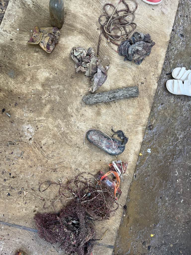
large rubber ring, anchor with approx 20 ft of chain, 3 pieces of aluminum rectangular frames, metal fishing net, half of a dive flag pole, cardboard bait box and approx. 300 ft of anchor rope and 100ft of monofilament fishing line
A large, female nurse shark circled the group for a while with a large hook embedded in her lower jaw.
1
anchor with chain
Key Dives
Morgan Gardner
17
1
1
86.00
40
80.00
60.00
measured
1000.00
1
On
pounds
I have debris data to report
Smooth (wavelets) for waves 0.1 - 0.5 meter high
Injured
Nurse Shark
1
ft2
300
feet
coral reef
Fishing hook
4
United States
State\Province
Florida
City
Islamorada
Map Help
Dive Location
If you know your survey site coordinates, enter them manually in decimal degrees using WGS84 Map Datum. Use the minus sign for latitudes south of the equator and longitudes west of the Prime Meridian to 180 degrees.
If you do not know your survey site coordinates, click the “Map Location” tab to use the map to zoom into your survey site and drop the pin on the map to fall within your survey dive site in the water (not on land or the beach). Ensure you zoom in as much as possible to ensure data accuracy.
Entangled Help
Use the vertical tabs below to record any entangled animals you found of each type.
Moderate to rough for waves greater than 1.25 meters
0
0
0
0
0
0
0
m2
0
0
feet
rocky reef
0
0
0
0
0
0
0
0
0
0
0
0
0
0
0
0
0
0
0
0
0
0
0
0
0
0
0
0
0
Language
English
Barbados
State\Province
St.Michael
City
Bridgetown
Map Help
Dive Location
If you know your survey site coordinates, enter them manually in decimal degrees using WGS84 Map Datum. Use the minus sign for latitudes south of the equator and longitudes west of the Prime Meridian to 180 degrees.
If you do not know your survey site coordinates, click the “Map Location” tab to use the map to zoom into your survey site and drop the pin on the map to fall within your survey dive site in the water (not on land or the beach). Ensure you zoom in as much as possible to ensure data accuracy.
Entangled Help
Use the vertical tabs below to record any entangled animals you found of each type.
If you know your survey site coordinates, enter them manually in decimal degrees using WGS84 Map Datum. Use the minus sign for latitudes south of the equator and longitudes west of the Prime Meridian to 180 degrees.
If you do not know your survey site coordinates, click the “Map Location” tab to use the map to zoom into your survey site and drop the pin on the map to fall within your survey dive site in the water (not on land or the beach). Ensure you zoom in as much as possible to ensure data accuracy.
Entangled Help
Use the vertical tabs below to record any entangled animals you found of each type.
With heavy rain we think the debri got blown down onto the reef
Rainy
Rogers scuba shack
Seth
0
0
0
0
0
0
0
0
0
0
0
0
0
0
0
0
0
0
0
8
0
0
0
0
0
0
0
0
0
0
0
0
0
0
0
0
1.00
45
50.00
40.00
0
estimated
0
0
7689.56
0
0
0
0
0
0
On
pounds
0
I have debris data to report
0
0
0
Moderate to rough for waves greater than 1.25 meters
0
0
0
0
0
0
0
m2
0
0
feet
rocky reef
8
0
0
0
0
0
0
0
0
0
0
0
0
0
0
0
0
0
0
0
0
0
0
0
0
0
0
0
0
Language
English
Barbados
State\Province
St.Michael
City
Bridgetown
Map Help
Dive Location
If you know your survey site coordinates, enter them manually in decimal degrees using WGS84 Map Datum. Use the minus sign for latitudes south of the equator and longitudes west of the Prime Meridian to 180 degrees.
If you do not know your survey site coordinates, click the “Map Location” tab to use the map to zoom into your survey site and drop the pin on the map to fall within your survey dive site in the water (not on land or the beach). Ensure you zoom in as much as possible to ensure data accuracy.
Entangled Help
Use the vertical tabs below to record any entangled animals you found of each type.
If you know your survey site coordinates, enter them manually in decimal degrees using WGS84 Map Datum. Use the minus sign for latitudes south of the equator and longitudes west of the Prime Meridian to 180 degrees.
If you do not know your survey site coordinates, click the “Map Location” tab to use the map to zoom into your survey site and drop the pin on the map to fall within your survey dive site in the water (not on land or the beach). Ensure you zoom in as much as possible to ensure data accuracy.
Entangled Help
Use the vertical tabs below to record any entangled animals you found of each type.
Celebrating 40 years of service - including insurance for divers, dive centers, and dive professionals, DAN Europe’s Maldives' partner, Allied Insurance Company , kicked off the celebration of this milestone last weekend with Dive40—a Dive Against Debris survey supporting PADI AWARE’s mission to drive local action for global ocean conservation.
Divers, often the first to witness the human impact on marine environments, are uniquely positioned to report, remove, and advocate for the prevention of marine debris at its source. By collecting and quantifying this data, Allied Insurance's CSR event contributes to the world’s largest underwater marine debris database, furthering efforts to protect our oceans.
The survey area is a docking jetty for commercial fisher boats that drop off their catch to be weighed and purchased by the fish factories on the island.
During a dedicated three-hour ocean cleanup on 11 January Saturday, the team of divers successfully removed an impressive 574 kg of marine debris from a part of Himmafushi lagoon. While plastic made up the majority of items by count, rubber tires (214 kg) and metal (170 kg) outweighed the plastic (106 kg) by weight. We had the opportunity to deliver an awareness session to school students and the local population of the island. The session highlighted the scourge of plastic pollution, emphasizing the adverse effects of plastic fragmenting into microplastics, disrupting marine ecosystems, and eventually entering the food chain through fish and seafood. We advocated for responsible plastic use, encouraging the avoidance of single-use plastics and promoting the principles of reducing, reusing, and recycling.
A two-stove cooker.
Found three white-eyed moray eels inside a beached PVC pipe. They were released safely back into the ocean.
Scattered rain with isolated heavy showers and thunderstorms.
Maldivian Academy of Diving
Adam Ashraf
0
5
8
1
0
0
0
0
0
0
0
0
2
0
0
0
0
2
0
21
0
0
0
0
2
0
38
0
0
6
0
0
0
0
0
0
574.06
45
7.00
4.00
0
measured
0
0
0
2000.00
213
10
Plastic packaging and bags, reflecting a convenience-driven lifestyle that is pervasive across the country.
Plastic tires, commonly used as fenders on boats, was a frequent find at the busy jetty with high traffic from fishing boats.
Plastic fishing lines left behind by anglers are a frequent debris at jetties across the country.
On
kilograms
I have debris data to report
8
Calm (glassy to rippled) for waves 0 – 0.1 meter high
2
0
0
Released Unharmed
Gymnothorax thyrsoideus
3
PVC Pipe
0
0
0
8
m2
0
17
meters
other
3
0
98
4
0
0
0
0
0
0
0
0
36
0
0
0
31
23
0
0
0
0
0
0
0
11
0
0
0
Language
English
Maldives
State\Province
North Male' Atoll
City
Himmafushi
Map Help
Dive Location
If you know your survey site coordinates, enter them manually in decimal degrees using WGS84 Map Datum. Use the minus sign for latitudes south of the equator and longitudes west of the Prime Meridian to 180 degrees.
If you do not know your survey site coordinates, click the “Map Location” tab to use the map to zoom into your survey site and drop the pin on the map to fall within your survey dive site in the water (not on land or the beach). Ensure you zoom in as much as possible to ensure data accuracy.
Entangled Help
Use the vertical tabs below to record any entangled animals you found of each type.