Menu

Skala Sikamineas breakwater and harbour mouth, Lesvos, Greece

6
rock
1
2

39.37434357484, 26.302685653791

I am currently volunteer crew on a rescue boat for Refugee Rescue, a Nongovernmental Organisation that provides afloat search and rescue support to the Hellenic Coast Guard for refugees crossing the Aegean.

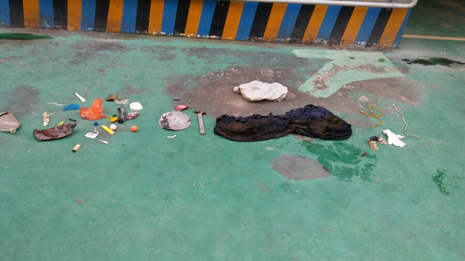
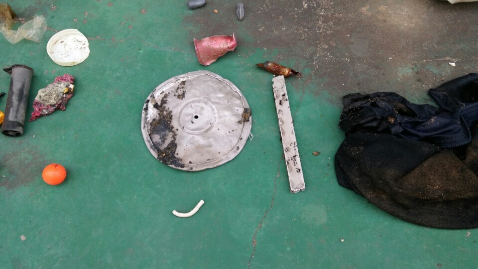
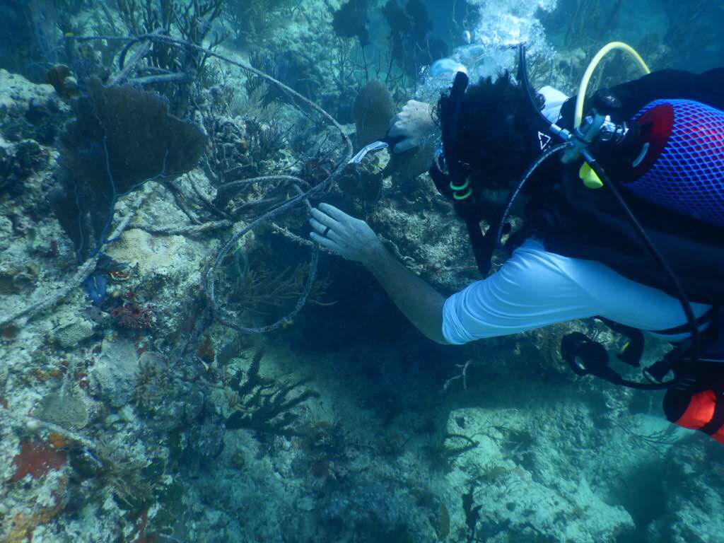
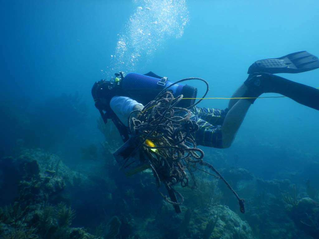
The crossings, as well as being a humanitarian crisis, are posing an ecological disaster to the Aegean and the Mediterranean, as the concentration of abandoned plastics (personal possessions, sunken dinghies, lost buoyancy aids, water bottles etc) is greater than anywhere I have ever dived previously.

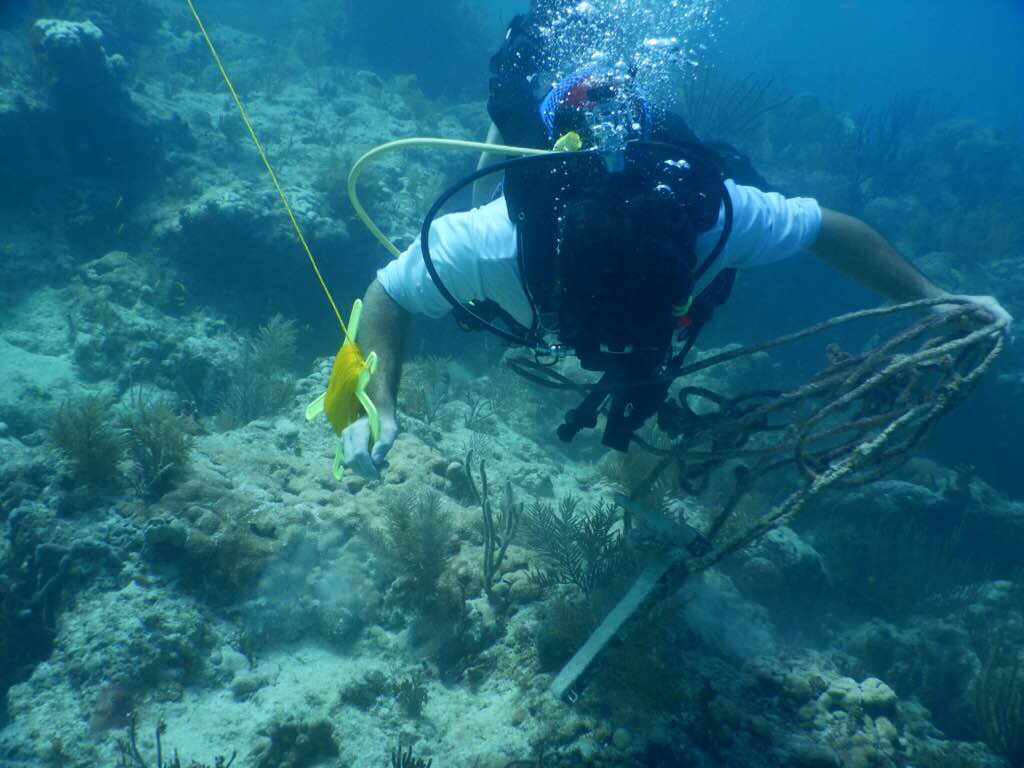
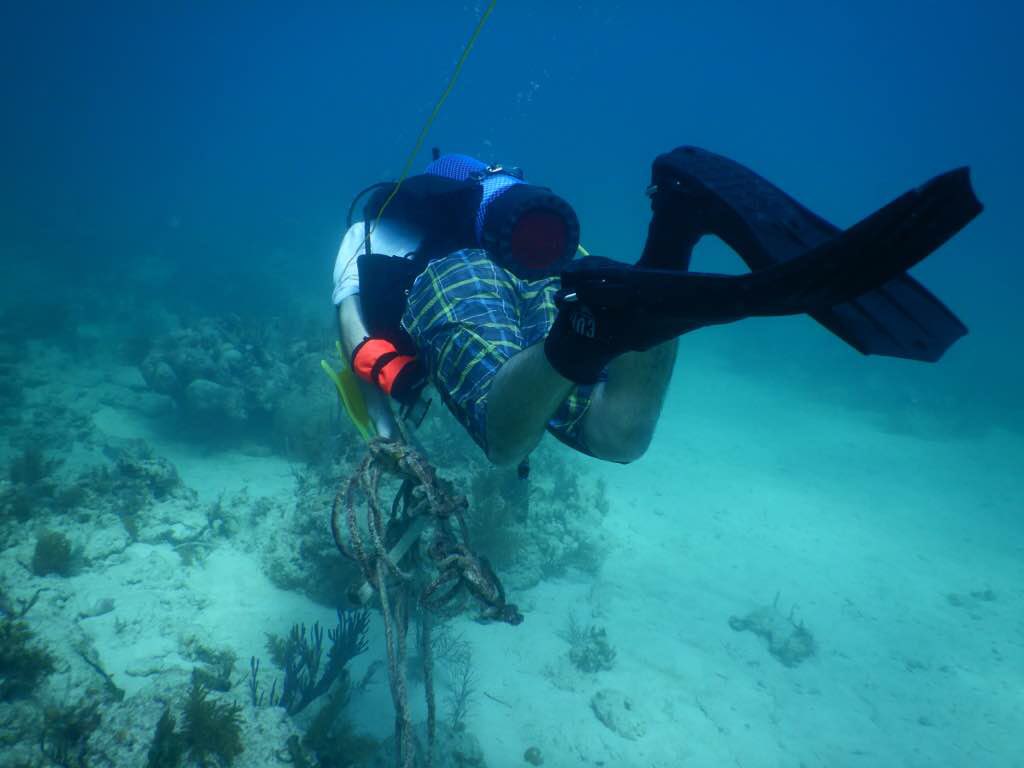
There are 2 abandoned vinyl dinghies on the breakwater above the waterline that I intend to access from shore and cut up into sections for disposal and removal.
Shore fishing (2 lengths of monofilament aligned with shore slipway), commercial day boat fishing (ghost gear pot found in harbour mouth.
This dive has been conducted as a Skin Dive Against Debris as most debris is easily within skin diving depths.

I am a PADI OWSI and an activist diver with Fathoms Free, Newquay, UK.
North Easterlies with intermittent showers and rainfall.
Fathoms Free
Jan Ziolo
3
1
2
3.00
70
10.00
2.00
estimated
1
83.00
On
kilograms
I have debris data to report
Slight for waves 0.5 -1.25 meter high m2
meters
seagrass
United Kingdom
State\Province
Cornwall
City
Newquay
Map Help


Dive Location

If you know your survey site coordinates, enter them manually in decimal degrees using WGS84 Map Datum. Use the minus sign for latitudes south of the equator and longitudes west of the Prime Meridian to 180 degrees.

If you do not know your survey site coordinates, click the “Map Location” tab to use the map to zoom into your survey site and drop the pin on the map to fall within your survey dive site in the water (not on land or the beach). Ensure you zoom in as much as possible to ensure data accuracy.

Entangled Help


Use the vertical tabs below to record any entangled animals you found of each type.

ADS381 - Los Cristianos Beach

0
1
0
0

28.05, -16.716667

0
0
0
sand
0
2
1
0
0
Yes
Anclas
Perfect
Ocean Dreams Tenerife
Daniel Anton Perez
0
0
0
0
52
0
0
0
0
0
0
0
0
1
0
0
0
0
4
15
2
5
0
0
1
0
0
1
0
1
1
0
0
0
0
0
5.00
150
6.00
0.00
2
estimated
0
0
0
2
25196.10
0
0
0
0
0
Colillas de cigarro
0
On
kilograms
0
I have debris data to report
2
0
0
Calm (glassy to rippled) for waves 0 – 0.1 meter high
3
0
0
0
0
0
0
m2
5
2
meters
rocky reef
0
0
0
1
0
0
0
0
0
0
0
0
1
1
0
0
0
2
0
0
0
0
3
0
1
0
4
0
0
Spain
State\Province
Arona, Tenerife
City
Los Cristianod
Map Help


Dive Location

If you know your survey site coordinates, enter them manually in decimal degrees using WGS84 Map Datum. Use the minus sign for latitudes south of the equator and longitudes west of the Prime Meridian to 180 degrees.

If you do not know your survey site coordinates, click the “Map Location” tab to use the map to zoom into your survey site and drop the pin on the map to fall within your survey dive site in the water (not on land or the beach). Ensure you zoom in as much as possible to ensure data accuracy.

Entangled Help


Use the vertical tabs below to record any entangled animals you found of each type.

Benwood Wreck

25.052667, -80.333667

sand
Scuba Center
Rick Figueroa
1
4
0.01
26
51.00
22.00
estimated
30.00
Plastics
On
pounds
I have debris data to report
Slight for waves 0.5 -1.25 meter high ft2
feet
rocky reef
United States
State\Province
Minnesota
City
Eagan
Map Help


Dive Location

If you know your survey site coordinates, enter them manually in decimal degrees using WGS84 Map Datum. Use the minus sign for latitudes south of the equator and longitudes west of the Prime Meridian to 180 degrees.

If you do not know your survey site coordinates, click the “Map Location” tab to use the map to zoom into your survey site and drop the pin on the map to fall within your survey dive site in the water (not on land or the beach). Ensure you zoom in as much as possible to ensure data accuracy.

Entangled Help


Use the vertical tabs below to record any entangled animals you found of each type.

ADS126 - Chilpo Beach Northern Rocky outcrop

15

36.136072, 129.398292

1
2
sand
1
I'm hoping to reach 2017 goal with dives on the 23rd and 24th.
Area was the cleanest I have ever seen it. Granted, the waves at this location have been high for what seems like a long time. Much of the beach was eroded away with a high wall of sand where the waves had cut into the beach.
Clear mostly. Its been a wild fall and winter with high seas nearly every weekend.
Dive Against Debris Korea (Daegu)
William Henderson
-1
1
1
2
5.00
27
5.00
1.00
2
estimated
2
13.00
On
kilograms
I have debris data to report
Smooth (wavelets) for waves 0.1 - 0.5 meter high
2
1
1
m2
meters
rocky reef
2
1
1
South Korea
State\Province
Gyeongsang-bukdo
City
Pohang
Map Help


Dive Location

If you know your survey site coordinates, enter them manually in decimal degrees using WGS84 Map Datum. Use the minus sign for latitudes south of the equator and longitudes west of the Prime Meridian to 180 degrees.

If you do not know your survey site coordinates, click the “Map Location” tab to use the map to zoom into your survey site and drop the pin on the map to fall within your survey dive site in the water (not on land or the beach). Ensure you zoom in as much as possible to ensure data accuracy.

Entangled Help


Use the vertical tabs below to record any entangled animals you found of each type.

Semporna, Sabah, Malaysia

sand

4.5044462958937, 118.62438440323

这一次我本人组织海洋清洁活动非常顺利,谢谢JUDY WANG 教练#391264和 Bryan Lim 教练#372017一同参与此活动,也谢谢Singamata经理Vicky的陆地协助,谢谢。
希望PADI可以组织一次在马来西亚仙本那海岛做一次海洋保护活动,因为这里几乎都是PADI潜水中心和PADI潜水教练比较多的地方,若PADI组织一场海洋保护活动的话,估计会有很多潜水中心和潜水教练都会参与。
very good
Singamata Reef Resort
Boonsuan Tan
4
1
6
73
9
59
1
82.00
70
15.00
4.00
estimated
30.00
On
kilograms
I have debris data to report
Calm (glassy to rippled) for waves 0 – 0.1 meter high m2
meters
coral reef
8
18
1
Malaysia
State\Province
SABAH
City
SEMPORNA
Map Help


Dive Location

If you know your survey site coordinates, enter them manually in decimal degrees using WGS84 Map Datum. Use the minus sign for latitudes south of the equator and longitudes west of the Prime Meridian to 180 degrees.

If you do not know your survey site coordinates, click the “Map Location” tab to use the map to zoom into your survey site and drop the pin on the map to fall within your survey dive site in the water (not on land or the beach). Ensure you zoom in as much as possible to ensure data accuracy.

Entangled Help


Use the vertical tabs below to record any entangled animals you found of each type.

The Next Wave Submission 1513696018

User Name
barend schipper
User Email
User Country
NL
Top Issue
cleanocean
Ocean Lover Type
all of the above

ADS184 - Gold Coast Seaway

3
10
1

-27.93664, 153.426301

18
rock
3
456
Fishing Debris Breakdown -
Sinkers - 265
Hooks - 273
Swivels - 143
Lures - 18
Fishing Reel - 2
Heavily fished area
Our last Monthly Maintenance Dive of 2017 in the Gold Coast Seaway.
Every single person on this dive released or assisted in the release of at least one Marine Animal. Rays, Eels and Fish were all found and released if possible, unfortunately we also found 3 dead marine animals, an Estuary Ray, Moray Eel and Brim.
Dive Computer
Calm
2
1
Fishing Reels
Dive Computer
Environmental Divers
Kelly Fletcher
1
2
2
5
1
8
3
1
1
1
42.90
48
18.00
3.00
6
measured
1
699
100.00
4
1
Fishing Line
Lead Sinkers
Hooks
1
On
kilograms
I have debris data to report
4
Smooth (wavelets) for waves 0.1 - 0.5 meter high
1
Hook and line entangled
10
Released Unharmed
Estuary Stingray
5
m2
1
meters
other
1
1
1
11
15
5
Australia
State\Province
Queensland
City
Gold Coast
Map Help


Dive Location

If you know your survey site coordinates, enter them manually in decimal degrees using WGS84 Map Datum. Use the minus sign for latitudes south of the equator and longitudes west of the Prime Meridian to 180 degrees.

If you do not know your survey site coordinates, click the “Map Location” tab to use the map to zoom into your survey site and drop the pin on the map to fall within your survey dive site in the water (not on land or the beach). Ensure you zoom in as much as possible to ensure data accuracy.

Entangled Help


Use the vertical tabs below to record any entangled animals you found of each type.

Ecosystem Other
Man made seaway entrance, rock wall with sand bottom

Brewster Canyon

0
0
0

25.575417, -80.099217

0
0
0
coral
0
0
0
0
0
No
Still a lot of debris at this site
Rope
Wrapped around boulders in tangled in coral
Sunny
0
0
0
0
0
0
0
0
0
0
0
0
0
0
0
0
0
0
0
0
Deep Foundation Inc
The Bay Diver
0
0
0
0
0
0
0
0
0
0
0
0
0
0
0
0
0
0
0
3
0
0
0
0
0
0
0
0
0
0
0
0
0
0
15.00
45
35.00
25.00
0
estimated
0
0
608.88
0
0
0
0
0
Rope
Ghost traps
Fishing line
0
On
pounds
0
I have debris data to report
0
0
0
Smooth (wavelets) for waves 0.1 - 0.5 meter high
0
0
0
0
0
0
0
ft2
4
0
1
Rope
Coral
Injured
feet
coral reef
0
0
0
0
0
0
0
0
0
0
0
0
0
0
0
0
0
0
0
0
0
0
0
0
0
0
0
0
United States
State\Province
Florida
City
Miami
Map Help


Dive Location

If you know your survey site coordinates, enter them manually in decimal degrees using WGS84 Map Datum. Use the minus sign for latitudes south of the equator and longitudes west of the Prime Meridian to 180 degrees.

If you do not know your survey site coordinates, click the “Map Location” tab to use the map to zoom into your survey site and drop the pin on the map to fall within your survey dive site in the water (not on land or the beach). Ensure you zoom in as much as possible to ensure data accuracy.

Entangled Help


Use the vertical tabs below to record any entangled animals you found of each type.

ADS184 - Gold Coast Seaway

2
57
1

-27.93664, 153.426301

27
rock
15
1
683
4
Heavily fished area
South West Wall Entry
Mirror
Fair
1
1
1
1
Surf Strap
Scissors
Mirror
Clothes Peg
Environmental Divers
Kelly Fletcher
6
36
2
5
1
1
15
1
9
3
2
3
1
7
3
1
1
3
34.30
98
8.00
2.00
2
measured
141
70.00
2
Fishing Line
Lead Sinkers
Hooks
On
kilograms
I have debris data to report
5
Slight for waves 0.5 -1.25 meter high
1
1
6
m2
9
meters
other
2
3
3
2
97
1
4
13
2
Australia
State\Province
Queensland
City
Gold Coast
Map Help


Dive Location

If you know your survey site coordinates, enter them manually in decimal degrees using WGS84 Map Datum. Use the minus sign for latitudes south of the equator and longitudes west of the Prime Meridian to 180 degrees.

If you do not know your survey site coordinates, click the “Map Location” tab to use the map to zoom into your survey site and drop the pin on the map to fall within your survey dive site in the water (not on land or the beach). Ensure you zoom in as much as possible to ensure data accuracy.

Entangled Help


Use the vertical tabs below to record any entangled animals you found of each type.

Ecosystem Other
Man made seaway entrance, rock wall with sand bottom

The Wreck

9.335798, -82.255196

sand

9.3353444449852, -82.255668975413

Lack of Education, rubbish disposal must be paid on this island so that's why they throw away things to the ocean
washing machine
stove
printer
Storm
Bocas Diving Pirates
Francisco Aguilar
6
6
30.00
40
9.50
3.00
estimated
100.00
On
kilograms
I have debris data to report
Calm (glassy to rippled) for waves 0 – 0.1 meter high m2
meters
coral reef
2
2
Panama
City
Bocas del Toro
Map Help


Dive Location

If you know your survey site coordinates, enter them manually in decimal degrees using WGS84 Map Datum. Use the minus sign for latitudes south of the equator and longitudes west of the Prime Meridian to 180 degrees.

If you do not know your survey site coordinates, click the “Map Location” tab to use the map to zoom into your survey site and drop the pin on the map to fall within your survey dive site in the water (not on land or the beach). Ensure you zoom in as much as possible to ensure data accuracy.

Entangled Help


Use the vertical tabs below to record any entangled animals you found of each type.

Subscribe to