Menu

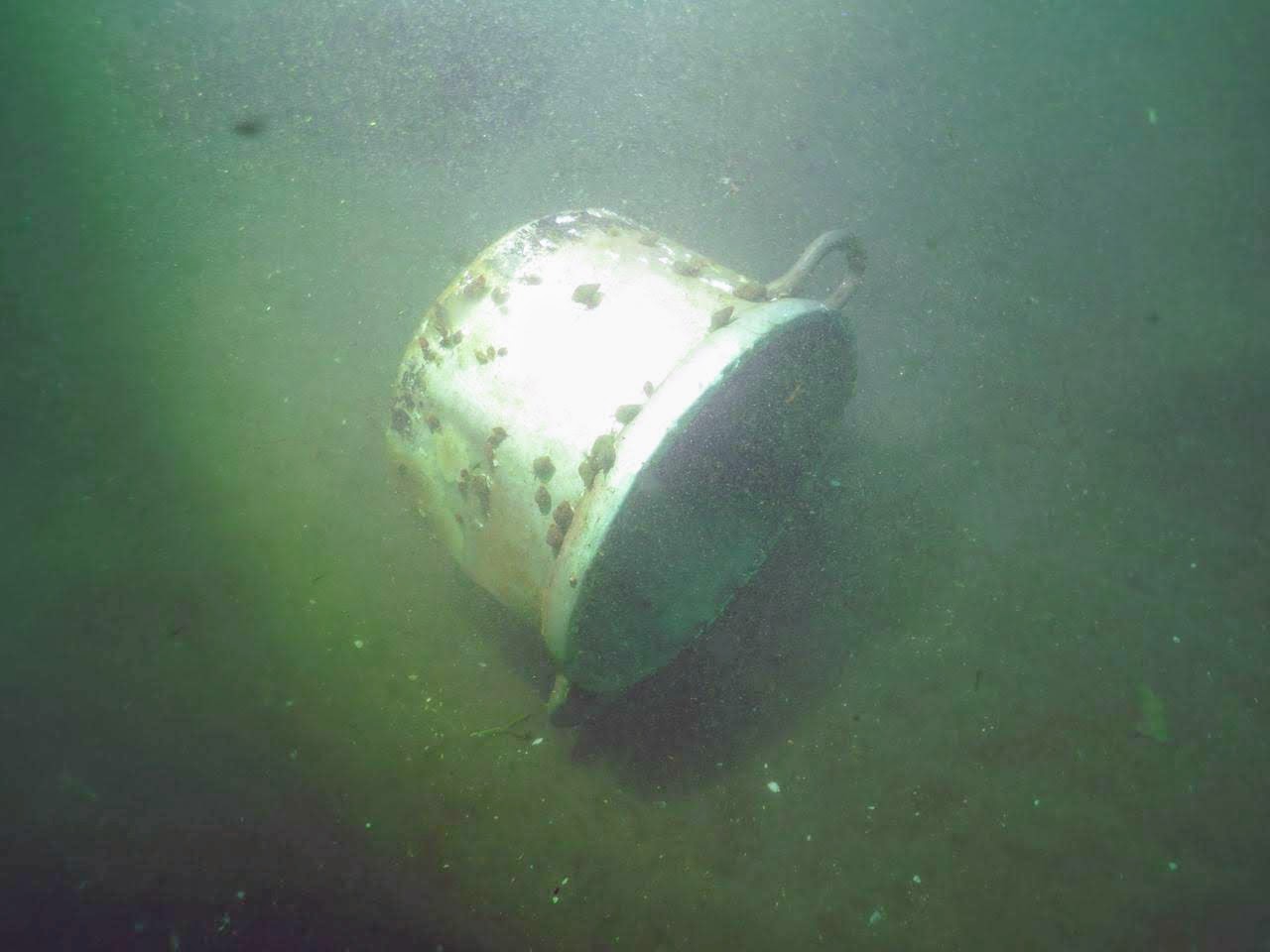
ADS38 - Breviks Gamla Brygga

silt

59.211193748031, 18.397333721614

Rubber hose
Anna Axelsson
2
1
10.00
30
14.00
5.00
estimated
60.00
1
Aluminum cans
On
kilograms
I have debris data to report
8
Smooth (wavelets) for waves 0.1 - 0.5 meter high m2
meters
other
1
3
2
Sweden
Map Help


Dive Location

If you know your survey site coordinates, enter them manually in decimal degrees using WGS84 Map Datum. Use the minus sign for latitudes south of the equator and longitudes west of the Prime Meridian to 180 degrees.

If you do not know your survey site coordinates, click the “Map Location” tab to use the map to zoom into your survey site and drop the pin on the map to fall within your survey dive site in the water (not on land or the beach). Ensure you zoom in as much as possible to ensure data accuracy.

Entangled Help


Use the vertical tabs below to record any entangled animals you found of each type.

Ecosystem Other
Silty sand

ADS436 - Boca Simon

0
10
15
1

12.096534, -68.915141

3
1
0
coral
0
17
0
470
0
No
No
No
Grinder
Normal
9
Golf ball
Atlantis Diving Curacao
Renske Van Den Nieuwelaar
1
1
0
27
0
0
0
0
1
0
0
0
0
1
0
0
0
3
0
5
3
0
1
1
0
3
5
0
0
0
0
0
0
0
0
0
40.00
60
18.00
1.00
0
estimated
0
0
0
117
518.76
1
0
0
0
1
Fishline
Fiskhooks and weights
Cups plastic
0
On
kilograms
0
I have debris data to report
18
0
0
Calm (glassy to rippled) for waves 0 – 0.1 meter high
0
0
4
0
0
0
0
m2
2
2
meters
coral reef
0
0
3
1
3
0
2
0
0
2
1
0
0
2
0
2
5
3
0
0
0
0
0
0
0
1
0
0
0
Netherlands Antilles
State\Province
Curacao
City
Willemstad
Map Help


Dive Location

If you know your survey site coordinates, enter them manually in decimal degrees using WGS84 Map Datum. Use the minus sign for latitudes south of the equator and longitudes west of the Prime Meridian to 180 degrees.

If you do not know your survey site coordinates, click the “Map Location” tab to use the map to zoom into your survey site and drop the pin on the map to fall within your survey dive site in the water (not on land or the beach). Ensure you zoom in as much as possible to ensure data accuracy.

Entangled Help


Use the vertical tabs below to record any entangled animals you found of each type.

Directorsbay

0
0
0
0

12.065892, -68.859961

0
0
0
coral
0
0
0
30
0
No
No
The clean up was for the world clean up day
Shoe
Normal
Atlantis Diving Curacao
Thomas Milde
0
0
0
0
0
0
0
0
0
0
0
0
0
0
0
0
0
0
0
5
0
0
0
0
0
0
0
0
0
0
0
0
0
0
0
0
30.00
60
21.00
1.00
0
estimated
0
0
0
26
302.20
0
0
0
0
0
Fishlines
Fishing weights
Shoe
0
On
kilograms
0
I have debris data to report
2
0
0
Calm (glassy to rippled) for waves 0 – 0.1 meter high
0
0
1
0
0
0
0
m2
0
0
meters
coral reef
0
0
0
0
0
0
0
0
0
0
0
0
0
0
0
0
1
0
0
0
0
0
0
0
0
0
0
2
0
Netherlands Antilles
State\Province
Curacao
City
Willemstad
Map Help


Dive Location

If you know your survey site coordinates, enter them manually in decimal degrees using WGS84 Map Datum. Use the minus sign for latitudes south of the equator and longitudes west of the Prime Meridian to 180 degrees.

If you do not know your survey site coordinates, click the “Map Location” tab to use the map to zoom into your survey site and drop the pin on the map to fall within your survey dive site in the water (not on land or the beach). Ensure you zoom in as much as possible to ensure data accuracy.

Entangled Help


Use the vertical tabs below to record any entangled animals you found of each type.

Sandbox

0
0
0
0

24.48152, -80.40922

0
0
0
coral
0
0
0
4
0
Commercial/Recreational Fishing and Hurricane Irma
Boat Anchor
Ideal , no storms
1
1
Anchor chain
Metal anchor
Key Dives/FKNMS
Cortney Benson
0
0
0
0
0
0
0
0
0
0
0
0
0
0
0
0
0
0
0
21
0
0
0
0
0
0
0
0
0
0
0
0
0
0
0
2
15.00
45
55.00
40.00
0
estimated
0
0
0
0
100.00
0
0
0
0
0
Lobster trap debris
Lobster line
Fishing line
0
On
pounds
0
I have debris data to report
0
0
0
Smooth (wavelets) for waves 0.1 - 0.5 meter high
31
0
0
0
0
0
0
m2
0
0
feet
coral reef
0
0
0
0
0
0
0
0
0
0
0
0
0
0
0
0
0
0
0
0
0
0
0
0
0
0
0
0
0
United States
State\Province
FL
City
Islamorada
Map Help


Dive Location

If you know your survey site coordinates, enter them manually in decimal degrees using WGS84 Map Datum. Use the minus sign for latitudes south of the equator and longitudes west of the Prime Meridian to 180 degrees.

If you do not know your survey site coordinates, click the “Map Location” tab to use the map to zoom into your survey site and drop the pin on the map to fall within your survey dive site in the water (not on land or the beach). Ensure you zoom in as much as possible to ensure data accuracy.

Entangled Help


Use the vertical tabs below to record any entangled animals you found of each type.

Canyon Land

0
0
0
0

24.4863, -80.4035

0
0
0
coral
0
2
0
0
0
Commercial/Recreational fishing and Hurricane Irma
8 pound round weight
Ideal, no storms
Key Dives/FKNMS
Cortney Benson
0
0
0
0
0
0
0
0
0
0
0
0
0
0
0
0
0
0
0
21
0
0
0
0
0
0
0
2
0
0
0
0
0
0
0
47
255.00
45
50.00
40.00
0
estimated
0
0
0
4
100.00
0
0
0
0
0
Lobster line
Lobster trap pieces (wood)
Crab traps pieces (metal)
0
On
pounds
0
I have debris data to report
1
0
0
Smooth (wavelets) for waves 0.1 - 0.5 meter high
160
0
0
0
0
0
0
m2
24
0
feet
coral reef
0
0
0
0
0
0
0
0
0
0
0
0
0
0
0
2
1
0
0
0
0
0
0
0
0
0
0
0
0
United States
State\Province
Florida
City
Islamorada
Map Help


Dive Location

If you know your survey site coordinates, enter them manually in decimal degrees using WGS84 Map Datum. Use the minus sign for latitudes south of the equator and longitudes west of the Prime Meridian to 180 degrees.

If you do not know your survey site coordinates, click the “Map Location” tab to use the map to zoom into your survey site and drop the pin on the map to fall within your survey dive site in the water (not on land or the beach). Ensure you zoom in as much as possible to ensure data accuracy.

Entangled Help


Use the vertical tabs below to record any entangled animals you found of each type.

ADS457 - Farallon's Rock

0
0
0
2

8.353615, -80.110495

1
0
0
silt
0
0
0
0
0
Local tourism
Strong swell
Scuba Caribe PANAMA
Maria Henriquez
1
0
0
0
0
0
0
0
0
0
0
0
0
0
0
0
0
0
0
3
0
0
0
0
1
0
1
0
0
0
0
0
0
0
0
0
1.00
50
20.00
5.00
0
estimated
0
0
0
0
200.00
0
0
0
0
0
0
On
pounds
0
I have debris data to report
1
0
0
Smooth (wavelets) for waves 0.1 - 0.5 meter high
0
0
0
0
0
0
0
m2
0
0
feet
rocky reef
0
0
0
0
0
0
0
0
0
0
0
0
0
0
0
0
0
0
0
0
0
0
0
0
0
0
0
0
0
Panama
State\Province
Cocle
City
Farallon
Map Help


Dive Location

If you know your survey site coordinates, enter them manually in decimal degrees using WGS84 Map Datum. Use the minus sign for latitudes south of the equator and longitudes west of the Prime Meridian to 180 degrees.

If you do not know your survey site coordinates, click the “Map Location” tab to use the map to zoom into your survey site and drop the pin on the map to fall within your survey dive site in the water (not on land or the beach). Ensure you zoom in as much as possible to ensure data accuracy.

Entangled Help


Use the vertical tabs below to record any entangled animals you found of each type.

Kadena South Steps

3
1

26.3216, 127.748

5
coral
3
100
No. The site we chose is popular for fishing which led to the collection of over 100 lines with hooks that were removed from the coral.
remnants of a steel 55 gallon drum.
Previous week was calm with little to no surf outside of normal tide shifts
Samurai Dive Club
Micheal Snider
1
1
10
1
6
1
1
1
65.00
52
62.00
10.00
estimated
1
25
800.00
1
On
pounds
I have debris data to report
1
Smooth (wavelets) for waves 0.1 - 0.5 meter high m2
feet
coral reef
19
2
1
1
3
10
Japan
State\Province
Okinawa
City
Uruma
Map Help


Dive Location

If you know your survey site coordinates, enter them manually in decimal degrees using WGS84 Map Datum. Use the minus sign for latitudes south of the equator and longitudes west of the Prime Meridian to 180 degrees.

If you do not know your survey site coordinates, click the “Map Location” tab to use the map to zoom into your survey site and drop the pin on the map to fall within your survey dive site in the water (not on land or the beach). Ensure you zoom in as much as possible to ensure data accuracy.

Entangled Help


Use the vertical tabs below to record any entangled animals you found of each type.

Gasconade River

0
0
0

38.186728031523, -91.907797399919

0
0
0
rock
0
6
0
0
0
Part of the Gasconade River Clean-up challenge
Flood
Old hair blow dryer
Rain
0
0
0
0
0
0
0
0
0
0
0
0
0
0
0
0
0
0
0
0
Scuba Adventure 2801
Harold “Chris” Heitman
0
0
0
0
23
0
0
0
0
0
0
0
0
0
0
0
0
0
0
56
0
0
0
0
0
0
0
0
0
0
0
0
0
0
450.00
45
26.00
3.00
0
estimated
0
0
2215.80
0
12
0
0
0
Large metal building parts
0
On
pounds
0
I have debris data to report
0
0
0
Calm (glassy to rippled) for waves 0 – 0.1 meter high
0
1
0
0
0
0
0
m2
0
0
feet
other
5
0
0
0
0
0
0
0
0
0
0
0
0
0
0
0
0
0
0
0
0
0
0
0
1
2
0
0
United States
State\Province
Missouri
City
Vienna
Map Help


Dive Location

If you know your survey site coordinates, enter them manually in decimal degrees using WGS84 Map Datum. Use the minus sign for latitudes south of the equator and longitudes west of the Prime Meridian to 180 degrees.

If you do not know your survey site coordinates, click the “Map Location” tab to use the map to zoom into your survey site and drop the pin on the map to fall within your survey dive site in the water (not on land or the beach). Ensure you zoom in as much as possible to ensure data accuracy.

Entangled Help


Use the vertical tabs below to record any entangled animals you found of each type.

Dive Against Debris Wellers Rock

-45.7978, 170.715

silt
21
1
No
Found dead must have been hiding in a bottle.
All regular items
Settled
Dive Otago Ltd
Emma
1
1
13
1
3.00
180
10.00
2.00
measured
460.00
1
Plastic bags and wrappers
beer bottles
wood fragments
On
kilograms
I have debris data to report
6
Calm (glassy to rippled) for waves 0 – 0.1 meter high
2
Baby Octopus
1
Dead
Octopus
m2
meters
kelp
1
1
1
2
New Zealand
State\Province
Otago
City
Dunedin
Map Help


Dive Location

If you know your survey site coordinates, enter them manually in decimal degrees using WGS84 Map Datum. Use the minus sign for latitudes south of the equator and longitudes west of the Prime Meridian to 180 degrees.

If you do not know your survey site coordinates, click the “Map Location” tab to use the map to zoom into your survey site and drop the pin on the map to fall within your survey dive site in the water (not on land or the beach). Ensure you zoom in as much as possible to ensure data accuracy.

Entangled Help


Use the vertical tabs below to record any entangled animals you found of each type.

Bahía de Pucusana

5
18
2
1

-12.473899216637, -76.795979066027

sand
2
5
5

-12.473899216637, -76.795979066027

Oil Filters wih oil inside
Some strong currents and waves day before the survey
10
1
1
1
1
Oil Filters
Light reflector
Scissor
Anchor
Energy switch
Spondylus Divecenter
Michael Epstein
3
5
2
2
1
2
23
21
1
1
5
1
17
4
-2
152.00
40
15.00
12.00
4
measured
1
300.00
2
10
11
Oil Filters
Plastic bottles
Tyres
On
kilograms
I have debris data to report
19
1
1
Moderate to rough for waves greater than 1.25 meters
5
9
9
1
m2
2
6
meters
other
8
1
1
5
10
4
8
24
1
2
6
39
6
Peru
State\Province
Lima
City
Lima
Map Help


Dive Location

If you know your survey site coordinates, enter them manually in decimal degrees using WGS84 Map Datum. Use the minus sign for latitudes south of the equator and longitudes west of the Prime Meridian to 180 degrees.

If you do not know your survey site coordinates, click the “Map Location” tab to use the map to zoom into your survey site and drop the pin on the map to fall within your survey dive site in the water (not on land or the beach). Ensure you zoom in as much as possible to ensure data accuracy.

Entangled Help


Use the vertical tabs below to record any entangled animals you found of each type.

Ecosystem Other
Mainly sand
Subscribe to