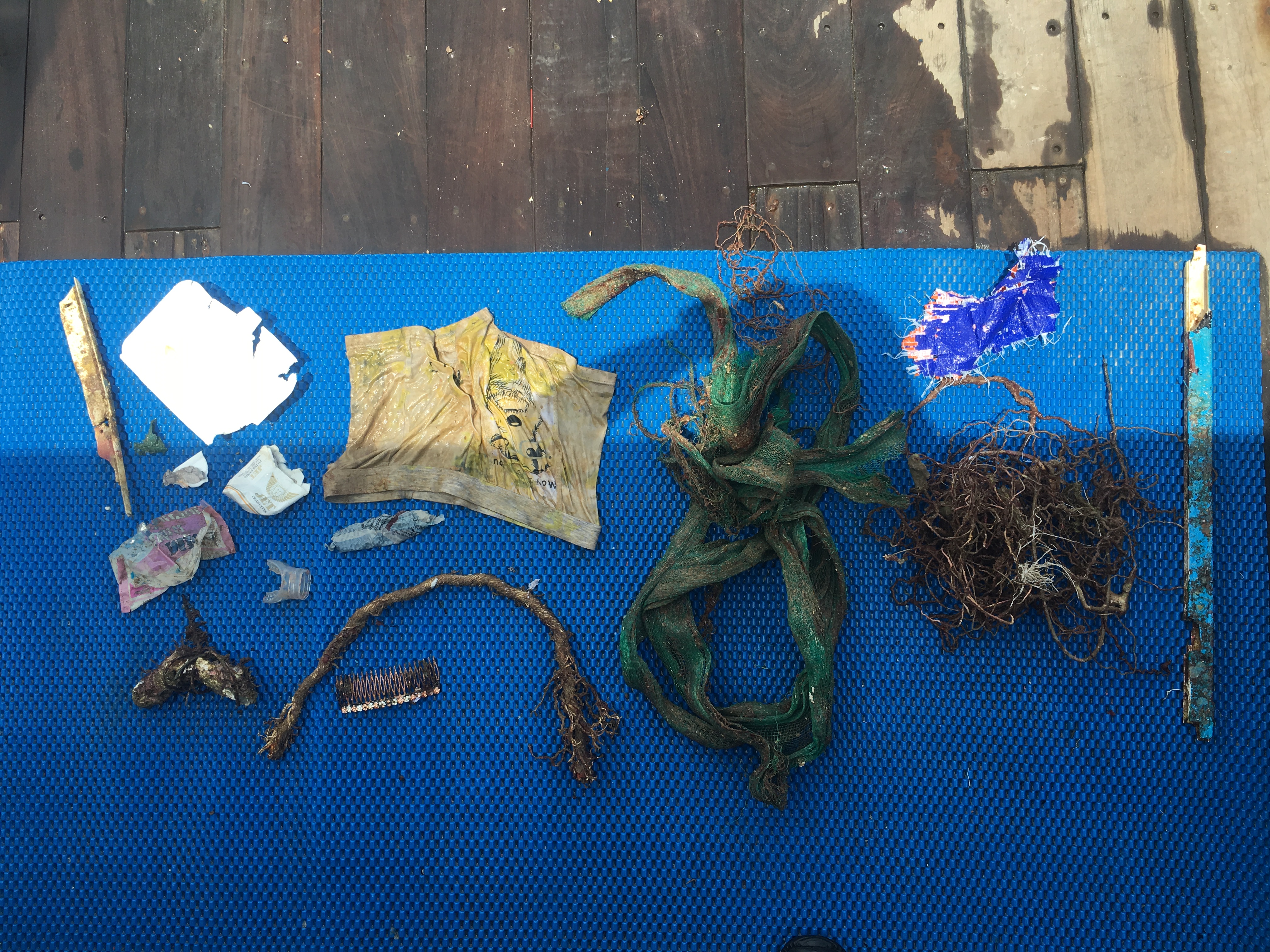
Fishing activities and tourist boats around the marine park
A pair of underpants
Mostly calm
1
Metal comb
Rainbow Divers
Maisie MacGregor
1
1
1
12
2.00
45
14.00
6.00
1
estimated
9000.00
Fishing line, which was often tangled around coral
Food packaging, as it seems it is carelessly thrown away into the ocean
On
kilograms
I have debris data to report
Smooth (wavelets) for waves 0.1 - 0.5 meter high
1
m2
meters
coral reef
1
Vietnam
State\Province
Khanh Hoa
City
Nha Trang
Map Help
Dive Location
If you know your survey site coordinates, enter them manually in decimal degrees using WGS84 Map Datum. Use the minus sign for latitudes south of the equator and longitudes west of the Prime Meridian to 180 degrees.
If you do not know your survey site coordinates, click the “Map Location” tab to use the map to zoom into your survey site and drop the pin on the map to fall within your survey dive site in the water (not on land or the beach). Ensure you zoom in as much as possible to ensure data accuracy.
Entangled Help
Use the vertical tabs below to record any entangled animals you found of each type.
Calm (glassy to rippled) for waves 0 – 0.1 meter high
0
0
0
Dead
Puffer Fish
1
Fishing line
0
1
0
0
m2
0
0
meters
rocky reef
3
0
0
0
0
2
0
1
0
0
0
0
0
1
0
0
7
0
0
0
0
19
0
0
0
0
0
0
Language
English
Spain
State\Province
Las Palmas
City
Puerto de Mogan
Map Help
Dive Location
If you know your survey site coordinates, enter them manually in decimal degrees using WGS84 Map Datum. Use the minus sign for latitudes south of the equator and longitudes west of the Prime Meridian to 180 degrees.
If you do not know your survey site coordinates, click the “Map Location” tab to use the map to zoom into your survey site and drop the pin on the map to fall within your survey dive site in the water (not on land or the beach). Ensure you zoom in as much as possible to ensure data accuracy.
Entangled Help
Use the vertical tabs below to record any entangled animals you found of each type.
Calm (glassy to rippled) for waves 0 – 0.1 meter high
0
0
0
0
0
0
0
m2
0
0
meters
rocky reef
0
0
0
0
0
0
0
4
0
2
0
0
0
0
0
2
0
0
0
0
0
0
0
0
0
0
1
0
Language
English
Cyprus
State\Province
Kyrenia
City
Esentepe
Map Help
Dive Location
If you know your survey site coordinates, enter them manually in decimal degrees using WGS84 Map Datum. Use the minus sign for latitudes south of the equator and longitudes west of the Prime Meridian to 180 degrees.
If you do not know your survey site coordinates, click the “Map Location” tab to use the map to zoom into your survey site and drop the pin on the map to fall within your survey dive site in the water (not on land or the beach). Ensure you zoom in as much as possible to ensure data accuracy.
Entangled Help
Use the vertical tabs below to record any entangled animals you found of each type.
Over the last weeks, we have had a lot of wind from the Northwest and West which brings in the garbage from the ocean.
Car spoiler
Wind force 7 - 9
Dive Smart Gozo
Oliver Benndorff
7
2
10
6
1
12
1
28
4
1
1
6
2
6.50
60
26.00
2.00
2
measured
334.37
1
plastic cups
cable ties
On
kilograms
I have debris data to report
2
Calm (glassy to rippled) for waves 0 – 0.1 meter high
2
1
2
m2
meters
rocky reef
16
1
1
1
1
4
25
1
Language
English
Malta
State\Province
Gozo
City
San Lawrenz, Dwejra
Map Help
Dive Location
If you know your survey site coordinates, enter them manually in decimal degrees using WGS84 Map Datum. Use the minus sign for latitudes south of the equator and longitudes west of the Prime Meridian to 180 degrees.
If you do not know your survey site coordinates, click the “Map Location” tab to use the map to zoom into your survey site and drop the pin on the map to fall within your survey dive site in the water (not on land or the beach). Ensure you zoom in as much as possible to ensure data accuracy.
Entangled Help
Use the vertical tabs below to record any entangled animals you found of each type.
Calm (glassy to rippled) for waves 0 – 0.1 meter high
0
0
0
0
0
0
0
m2
0
0
meters
coral reef
0
0
0
0
0
0
1
0
0
0
0
0
0
0
0
0
0
0
0
0
0
0
0
0
0
0
0
0
Language
English
Malaysia
State\Province
Johor
City
Mersing
Map Help
Dive Location
If you know your survey site coordinates, enter them manually in decimal degrees using WGS84 Map Datum. Use the minus sign for latitudes south of the equator and longitudes west of the Prime Meridian to 180 degrees.
If you do not know your survey site coordinates, click the “Map Location” tab to use the map to zoom into your survey site and drop the pin on the map to fall within your survey dive site in the water (not on land or the beach). Ensure you zoom in as much as possible to ensure data accuracy.
Entangled Help
Use the vertical tabs below to record any entangled animals you found of each type.
Calm (glassy to rippled) for waves 0 – 0.1 meter high
0
0
0
0
0
0
0
m2
0
0
meters
seagrass
0
0
0
0
0
0
0
0
0
0
0
0
0
0
0
0
0
0
0
0
0
0
0
0
0
0
0
0
Language
English
Germany
City
Cologne
Map Help
Dive Location
If you know your survey site coordinates, enter them manually in decimal degrees using WGS84 Map Datum. Use the minus sign for latitudes south of the equator and longitudes west of the Prime Meridian to 180 degrees.
If you do not know your survey site coordinates, click the “Map Location” tab to use the map to zoom into your survey site and drop the pin on the map to fall within your survey dive site in the water (not on land or the beach). Ensure you zoom in as much as possible to ensure data accuracy.
Entangled Help
Use the vertical tabs below to record any entangled animals you found of each type.
Calm (glassy to rippled) for waves 0 – 0.1 meter high
3
0
0
0
0
0
0
m2
0
0
meters
coral reef
1
0
0
0
0
0
0
0
0
0
0
0
0
0
0
0
0
0
0
0
0
0
0
0
0
0
0
0
0
Language
English
Indonesia
State\Province
West Nusa Tenggara
City
Gili Air
Map Help
Dive Location
If you know your survey site coordinates, enter them manually in decimal degrees using WGS84 Map Datum. Use the minus sign for latitudes south of the equator and longitudes west of the Prime Meridian to 180 degrees.
If you do not know your survey site coordinates, click the “Map Location” tab to use the map to zoom into your survey site and drop the pin on the map to fall within your survey dive site in the water (not on land or the beach). Ensure you zoom in as much as possible to ensure data accuracy.
Entangled Help
Use the vertical tabs below to record any entangled animals you found of each type.
The trash come from the city of Ambon. The city's waste disposal management is very bad.
Beautiful ocean with ugly debris. Need to push the government of Maluku, especially Ambon city to put more attention on the marine debris issues caused by the city.
Raining
Spice Island Divers
Rendra Hertiadhi
0
1
1
3
0
0
0
0
0
0
0
0
0
0
0
0
0
0
1
3
0
0
1
0
0
0
7
0
0
0
0
0
0
0
0
0
2.00
70
10.00
3.00
2
estimated
0
0
0
0
75.02
0
0
0
2
0
Plastic bags
Food packaging
Plastic bottle (PET)
0
On
kilograms
0
I have debris data to report
0
0
0
Calm (glassy to rippled) for waves 0 – 0.1 meter high
0
0
0
0
1
0
0
m2
0
0
meters
coral reef
1
0
0
0
0
0
0
0
0
0
0
0
0
0
0
0
0
0
0
0
0
0
1
0
0
0
0
0
0
Language
English
Indonesia
State\Province
Maluku
City
Ambon
Map Help
Dive Location
If you know your survey site coordinates, enter them manually in decimal degrees using WGS84 Map Datum. Use the minus sign for latitudes south of the equator and longitudes west of the Prime Meridian to 180 degrees.
If you do not know your survey site coordinates, click the “Map Location” tab to use the map to zoom into your survey site and drop the pin on the map to fall within your survey dive site in the water (not on land or the beach). Ensure you zoom in as much as possible to ensure data accuracy.
Entangled Help
Use the vertical tabs below to record any entangled animals you found of each type.
Calm (glassy to rippled) for waves 0 – 0.1 meter high
0
0
0
0
0
0
0
m2
0
0
feet
coral reef
0
0
0
0
0
0
0
0
0
0
0
0
0
0
0
0
0
0
0
0
0
0
0
0
0
0
0
0
0
Language
English
Jamaica
State\Province
St. Ann
City
Ocho Rios
Map Help
Dive Location
If you know your survey site coordinates, enter them manually in decimal degrees using WGS84 Map Datum. Use the minus sign for latitudes south of the equator and longitudes west of the Prime Meridian to 180 degrees.
If you do not know your survey site coordinates, click the “Map Location” tab to use the map to zoom into your survey site and drop the pin on the map to fall within your survey dive site in the water (not on land or the beach). Ensure you zoom in as much as possible to ensure data accuracy.
Entangled Help
Use the vertical tabs below to record any entangled animals you found of each type.