Menu

Biesanz Bay

5
sand
1
10

9.3639768220609, -84.165813443932

Area has used for snorkelling and man boats visit the area
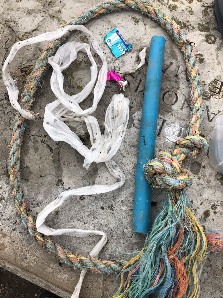
3 Apple Watches
Rain every day
2
Plastic Sunglasses
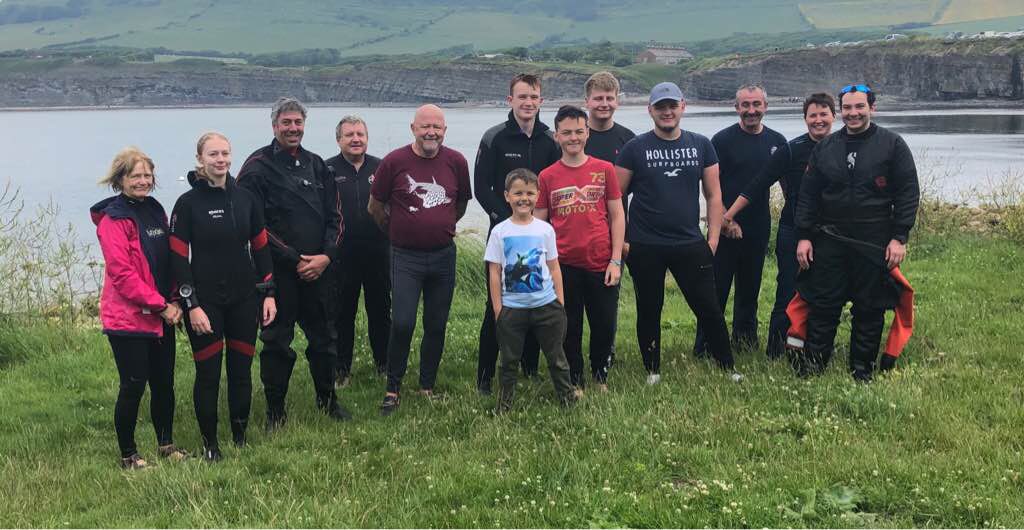
Oceans Unlimited and Marine Conservation Costa Rica
Jesse Crowe
4
1
26
7.00
60
30.00
20.00
2
estimated
10
500.00
fishing line
2
On
kilograms
I have debris data to report
Smooth (wavelets) for waves 0.1 - 0.5 meter high m2
10
feet
other
1
2
3
Costa Rica
State\Province
Puntarenas
City
Quepos
Map Help


Dive Location

If you know your survey site coordinates, enter them manually in decimal degrees using WGS84 Map Datum. Use the minus sign for latitudes south of the equator and longitudes west of the Prime Meridian to 180 degrees.

If you do not know your survey site coordinates, click the “Map Location” tab to use the map to zoom into your survey site and drop the pin on the map to fall within your survey dive site in the water (not on land or the beach). Ensure you zoom in as much as possible to ensure data accuracy.

Entangled Help


Use the vertical tabs below to record any entangled animals you found of each type.

Ecosystem Other
Sandy bottom and rocky reef

Kimmeridge Bay

0
0
0

50.609437686414, -2.1301241074429

0
0
0
rock
0
0
0
0
1
Easy access to site and very helpful and friendly local staff from Wildlife Trust
No
Very clean area
Plastic tube
Windy and overcast
3
0
0
0
0
0
0
0
0
0
0
0
0
0
0
0
0
0
0
Sweet wrapping
Andark Diving and Watersports
Steve Cook
0
0
0
0
0
0
0
0
0
0
0
0
0
0
0
0
0
0
0
10
0
0
0
0
0
0
0
0
0
0
0
0
0
0
1.50
25
5.00
2.00
0
estimated
0
0
50.00
0
0
0
0
0
Sweet wrappers
Rope
Plastic
0
On
kilograms
0
I have debris data to report
0
0
0
Smooth (wavelets) for waves 0.1 - 0.5 meter high
0
0
0
0
0
0
0
m2
1
0
meters
rocky reef
0
0
0
0
0
0
0
0
0
0
0
0
0
0
0
0
0
0
0
0
0
0
0
0
0
0
0
0
United Kingdom
State\Province
Dorset
City
Kimmeridge
Map Help


Dive Location

If you know your survey site coordinates, enter them manually in decimal degrees using WGS84 Map Datum. Use the minus sign for latitudes south of the equator and longitudes west of the Prime Meridian to 180 degrees.

If you do not know your survey site coordinates, click the “Map Location” tab to use the map to zoom into your survey site and drop the pin on the map to fall within your survey dive site in the water (not on land or the beach). Ensure you zoom in as much as possible to ensure data accuracy.

Entangled Help


Use the vertical tabs below to record any entangled animals you found of each type.

ADS47 - West Hawk Lake Cats Ass

0
0
0

49.746882570116, -95.208647843707

0
0
0
sand
0
0
0
0
0
Sunny, 20C
0
0
0
0
0
0
0
0
0
0
0
0
0
0
0
0
0
0
0
0
Diver City Scuba
Dave Shoesmith
0
0
0
0
0
0
0
0
0
0
0
0
0
0
0
0
0
0
0
2
0
0
0
0
0
0
0
0
0
0
0
0
0
0
0.50
10
15.00
2.00
0
estimated
0
0
400.00
0
0
0
0
0
0
On
kilograms
0
I have debris data to report
0
0
0
Calm (glassy to rippled) for waves 0 – 0.1 meter high
0
0
0
0
0
0
0
m2
0
0
feet
other
0
0
0
0
0
0
0
0
0
0
0
0
0
0
0
0
0
0
0
0
0
5
0
1
0
0
0
0
Canada
State\Province
Manitoba
City
West Hawk
Map Help


Dive Location

If you know your survey site coordinates, enter them manually in decimal degrees using WGS84 Map Datum. Use the minus sign for latitudes south of the equator and longitudes west of the Prime Meridian to 180 degrees.

If you do not know your survey site coordinates, click the “Map Location” tab to use the map to zoom into your survey site and drop the pin on the map to fall within your survey dive site in the water (not on land or the beach). Ensure you zoom in as much as possible to ensure data accuracy.

Entangled Help


Use the vertical tabs below to record any entangled animals you found of each type.

ADS528 - Radazul

122

28.401225, -16.32376

sand
1
1
121
3
Today we discovered a real underground dump in the sandy area: we could spot a lot of small part of objects surfacing from the bottom.
After we start to lift them we've been forced to work deep in the ground to recover it so we found and got out more debris including several fishing line and plastic containers.

However the situation in the rocky area was very clean compared with the previous events.

Tha microplastic is visible and still represent the biggest problem.
Fisherman, turistic boat and beach tourism activity,
Sunny, no wind
Scubanana
Andrea Pilone
1
2
1
2
3
1
11
3
3
1
1
12.00
45
13.00
3.00
estimated
2
7814.00
microplastic
fishing line
cans
On
kilograms
I have debris data to report
Calm (glassy to rippled) for waves 0 – 0.1 meter high
5
7
9
m2
3
1
meters
rocky reef
1
1
1
2
9
3
4
1
1
Spain
State\Province
Canary Islands
City
Radazul
Map Help


Dive Location

If you know your survey site coordinates, enter them manually in decimal degrees using WGS84 Map Datum. Use the minus sign for latitudes south of the equator and longitudes west of the Prime Meridian to 180 degrees.

If you do not know your survey site coordinates, click the “Map Location” tab to use the map to zoom into your survey site and drop the pin on the map to fall within your survey dive site in the water (not on land or the beach). Ensure you zoom in as much as possible to ensure data accuracy.

Entangled Help


Use the vertical tabs below to record any entangled animals you found of each type.

The Blue Lagoon

0
0
0

51.987125691671, -0.73765257173166

0
0
0
silt
0
0
0
0
0
No
Social dive in popular swimming lake
Polish beer bottle
Rain and sun
0
0
0
0
0
0
0
0
0
0
0
0
0
0
0
0
0
0
0
0
Rec2Tec Diving
Peter Ewart
0
0
0
0
0
0
0
0
0
0
0
0
0
0
0
0
0
0
0
2
0
0
0
0
0
0
0
0
0
0
0
0
0
0
3.00
40
18.00
4.00
0
estimated
0
0
12277.70
1
0
0
0
0
Glass bottles
Beer cans
0
On
kilograms
0
I have debris data to report
3
0
0
Calm (glassy to rippled) for waves 0 – 0.1 meter high
0
0
0
0
0
0
0
m2
0
0
meters
kelp
0
0
0
0
0
0
0
0
0
0
0
0
0
0
0
0
4
0
0
0
0
0
0
0
0
0
0
0
United Kingdom
State\Province
Bucks
City
Bletchley
Map Help


Dive Location

If you know your survey site coordinates, enter them manually in decimal degrees using WGS84 Map Datum. Use the minus sign for latitudes south of the equator and longitudes west of the Prime Meridian to 180 degrees.

If you do not know your survey site coordinates, click the “Map Location” tab to use the map to zoom into your survey site and drop the pin on the map to fall within your survey dive site in the water (not on land or the beach). Ensure you zoom in as much as possible to ensure data accuracy.

Entangled Help


Use the vertical tabs below to record any entangled animals you found of each type.

East Selsey Beach, Sussex. UK

0
0
0
0

50.732395, -0.773525

0
0
0
gravel
0
0
0
0
0
No
Fishing lure/weight
Onshore breeze, 14km/h average
1
Anchor
Divecrew, Crowthorne, Berkshire
Sue Coffey
0
0
0
0
0
0
0
0
0
0
2
0
0
2
0
0
0
0
0
7
0
0
0
0
0
0
0
0
0
0
0
0
0
0
0
0
2.00
40
5.00
0.00
0
measured
0
0
0
2
1606.58
0
0
0
0
0
0
On
kilograms
0
I have debris data to report
0
0
0
Calm (glassy to rippled) for waves 0 – 0.1 meter high
0
0
0
0
0
0
0
m2
0
0
meters
other
0
0
1
0
0
0
0
0
0
0
0
0
0
0
0
0
0
0
0
0
0
0
0
0
0
0
0
0
0
United Kingdom
State\Province
East Sussex
City
Selsey
Map Help


Dive Location

If you know your survey site coordinates, enter them manually in decimal degrees using WGS84 Map Datum. Use the minus sign for latitudes south of the equator and longitudes west of the Prime Meridian to 180 degrees.

If you do not know your survey site coordinates, click the “Map Location” tab to use the map to zoom into your survey site and drop the pin on the map to fall within your survey dive site in the water (not on land or the beach). Ensure you zoom in as much as possible to ensure data accuracy.

Entangled Help


Use the vertical tabs below to record any entangled animals you found of each type.

ADS299 - Sai Ree Reef

10.089461348847, 99.82529821258

coral
3
1
2
Tyre, maybe fell off a boat
Windy
simple life divers
Steve
2
6
6
8
3
2
1
20.00
45
6.00
1.00
2
estimated
40.00
1
plastic
caps
bottles
On
kilograms
I have debris data to report
2
Slight for waves 0.5 -1.25 meter high m2
1
meters
coral reef
3
4
1
1
Thailand
State\Province
surat thani
City
chumphon
Map Help


Dive Location

If you know your survey site coordinates, enter them manually in decimal degrees using WGS84 Map Datum. Use the minus sign for latitudes south of the equator and longitudes west of the Prime Meridian to 180 degrees.

If you do not know your survey site coordinates, click the “Map Location” tab to use the map to zoom into your survey site and drop the pin on the map to fall within your survey dive site in the water (not on land or the beach). Ensure you zoom in as much as possible to ensure data accuracy.

Entangled Help


Use the vertical tabs below to record any entangled animals you found of each type.

House Reef Gili Trawangan

2
3
1
1
coral
2
4

-8.3485476740069, 116.04336772283

https://www.projectaware.org/DiveAgainstDebrisData#
Fishing rod / unbroken
1
Lifejacket
Big Bubble Dive
Dan Sherwood
1
1
2
7
1
2
1
1
9.00
41
20.00
6.00
estimated
9762.00
On
kilograms
I have debris data to report
Calm (glassy to rippled) for waves 0 – 0.1 meter high
1
m2
1
meters
coral reef
3
2
Indonesia
State\Province
Lombok
City
Gili Trawangan
Map Help


Dive Location

If you know your survey site coordinates, enter them manually in decimal degrees using WGS84 Map Datum. Use the minus sign for latitudes south of the equator and longitudes west of the Prime Meridian to 180 degrees.

If you do not know your survey site coordinates, click the “Map Location” tab to use the map to zoom into your survey site and drop the pin on the map to fall within your survey dive site in the water (not on land or the beach). Ensure you zoom in as much as possible to ensure data accuracy.

Entangled Help


Use the vertical tabs below to record any entangled animals you found of each type.

ADS142 - Sabang Bay Puerto Galera

6
11
0

13.521685, 120.975398

0
0
0
sand
0
2
0
13
0
This DAD was conducted as part of our Instructor Development Course at Asiadivers. Www.asiadivers.com/GoPro
No
No
Nothing unusual
Sunny
0
0
0
0
0
0
0
0
0
0
0
0
0
0
0
0
0
0
0
0
Asia Divers
Sabine Henkel
1
0
0
0
0
0
0
0
0
0
0
0
0
24
0
0
0
0
1
3
0
0
0
0
0
0
3
0
0
0
0
0
0
0
5.25
55
18.00
5.00
21
measured
0
0
300.00
0
0
0
3
0
Nylon rope and strings
Fishing lines
Plastic fragments
4
On
kilograms
0
I have debris data to report
0
0
0
Calm (glassy to rippled) for waves 0 – 0.1 meter high
0
0
0
0
0
0
0
m2
2
0
meters
coral reef
0
0
0
0
0
0
0
0
0
1
0
0
0
0
0
0
1
0
0
0
0
1
2
0
0
0
0
0
Philippines
State\Province
Mindoro
City
Puerto Galera
Map Help


Dive Location

If you know your survey site coordinates, enter them manually in decimal degrees using WGS84 Map Datum. Use the minus sign for latitudes south of the equator and longitudes west of the Prime Meridian to 180 degrees.

If you do not know your survey site coordinates, click the “Map Location” tab to use the map to zoom into your survey site and drop the pin on the map to fall within your survey dive site in the water (not on land or the beach). Ensure you zoom in as much as possible to ensure data accuracy.

Entangled Help


Use the vertical tabs below to record any entangled animals you found of each type.

Octopus Rock

1

12.171103439769, 109.31296048494

coral
Hot and sunny
Sailing Club Divers
Max Smirnov
2
1
1.50
45
13.00
3.00
1
estimated
900.00
On
kilograms
I have debris data to report
Calm (glassy to rippled) for waves 0 – 0.1 meter high m2
1
meters
coral reef
4
Vietnam
State\Province
Khanh Hoa
City
Nha Trang
Map Help


Dive Location

If you know your survey site coordinates, enter them manually in decimal degrees using WGS84 Map Datum. Use the minus sign for latitudes south of the equator and longitudes west of the Prime Meridian to 180 degrees.

If you do not know your survey site coordinates, click the “Map Location” tab to use the map to zoom into your survey site and drop the pin on the map to fall within your survey dive site in the water (not on land or the beach). Ensure you zoom in as much as possible to ensure data accuracy.

Entangled Help


Use the vertical tabs below to record any entangled animals you found of each type.

Subscribe to