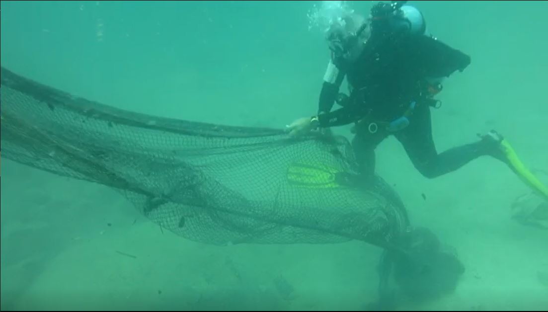
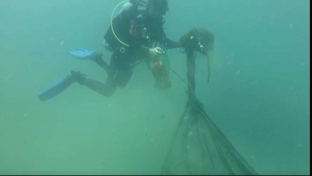
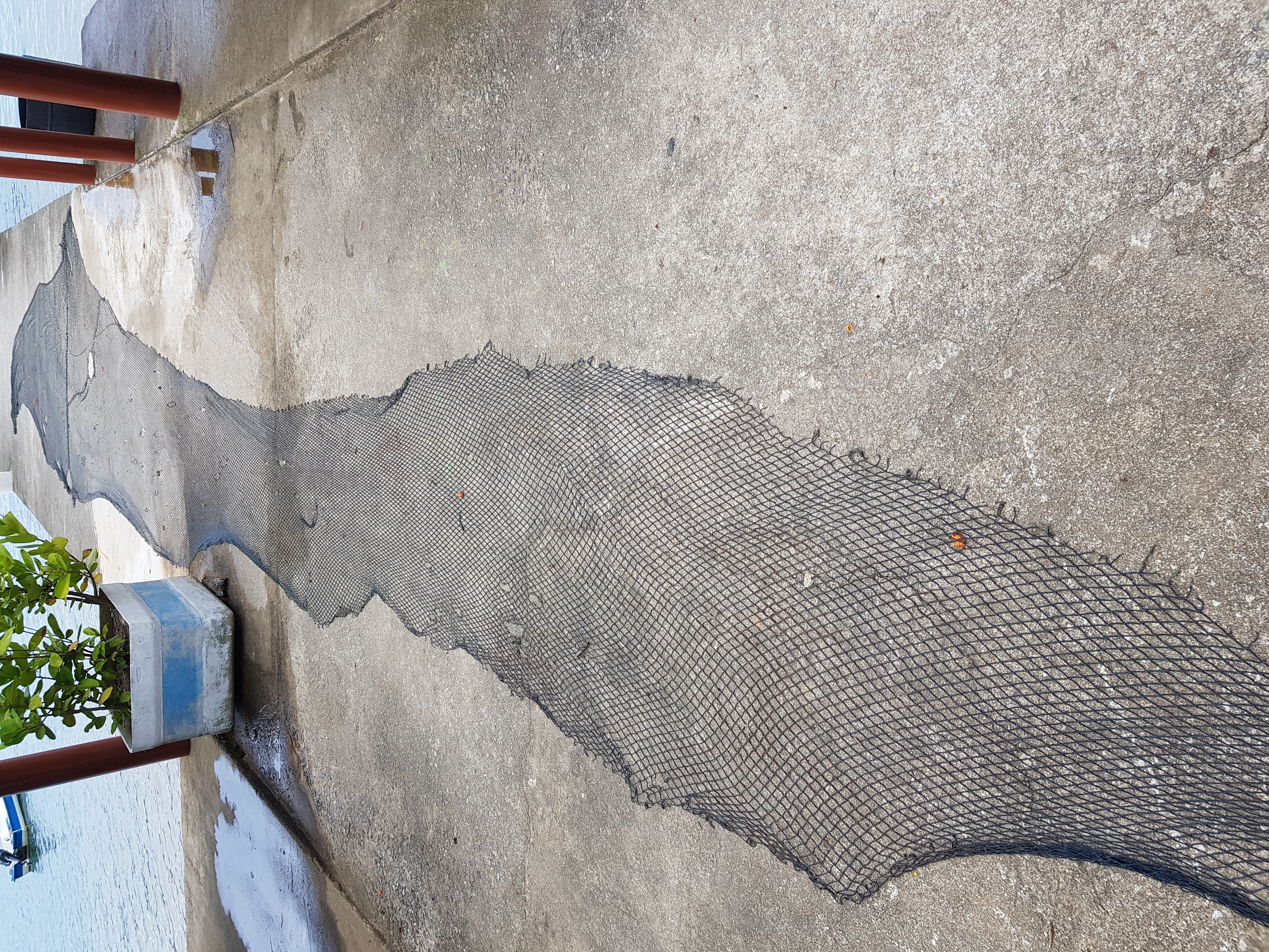
Calm (glassy to rippled) for waves 0 – 0.1 meter high
m2
8
Fishing Net
Sea Urchin
Released Unharmed
meters
rocky reef
Brazil
State\Province
Rio de Janeiro
City
Ilha Grande
Map Help
Dive Location
If you know your survey site coordinates, enter them manually in decimal degrees using WGS84 Map Datum. Use the minus sign for latitudes south of the equator and longitudes west of the Prime Meridian to 180 degrees.
If you do not know your survey site coordinates, click the “Map Location” tab to use the map to zoom into your survey site and drop the pin on the map to fall within your survey dive site in the water (not on land or the beach). Ensure you zoom in as much as possible to ensure data accuracy.
Entangled Help
Use the vertical tabs below to record any entangled animals you found of each type.
Calm (glassy to rippled) for waves 0 – 0.1 meter high
5
m2
3
meters
rocky reef
10
Language
English
Cyprus
State\Province
Famagusta
City
Protaras
Map Help
Dive Location
If you know your survey site coordinates, enter them manually in decimal degrees using WGS84 Map Datum. Use the minus sign for latitudes south of the equator and longitudes west of the Prime Meridian to 180 degrees.
If you do not know your survey site coordinates, click the “Map Location” tab to use the map to zoom into your survey site and drop the pin on the map to fall within your survey dive site in the water (not on land or the beach). Ensure you zoom in as much as possible to ensure data accuracy.
Entangled Help
Use the vertical tabs below to record any entangled animals you found of each type.
Calm (glassy to rippled) for waves 0 – 0.1 meter high
2
18
m2
meters
seagrass
15
2
1
Language
English
Egypt
State\Province
south Sinai
City
Dahab
Map Help
Dive Location
If you know your survey site coordinates, enter them manually in decimal degrees using WGS84 Map Datum. Use the minus sign for latitudes south of the equator and longitudes west of the Prime Meridian to 180 degrees.
If you do not know your survey site coordinates, click the “Map Location” tab to use the map to zoom into your survey site and drop the pin on the map to fall within your survey dive site in the water (not on land or the beach). Ensure you zoom in as much as possible to ensure data accuracy.
Entangled Help
Use the vertical tabs below to record any entangled animals you found of each type.
plans to go back for the bigger stuff with lift bags
Good
Dive HQ Auckland
Kyle Ford
1
2
2
3
2
2
6.00
33
15.00
4.00
estimated
200.00
glass
plastic
snorkels
On
kilograms
I have debris data to report
6
Calm (glassy to rippled) for waves 0 – 0.1 meter high
0
1
m2
1
meters
other
1
2
1
1
0
1
2
Language
English
New Zealand
City
Auckland
Map Help
Dive Location
If you know your survey site coordinates, enter them manually in decimal degrees using WGS84 Map Datum. Use the minus sign for latitudes south of the equator and longitudes west of the Prime Meridian to 180 degrees.
If you do not know your survey site coordinates, click the “Map Location” tab to use the map to zoom into your survey site and drop the pin on the map to fall within your survey dive site in the water (not on land or the beach). Ensure you zoom in as much as possible to ensure data accuracy.
Entangled Help
Use the vertical tabs below to record any entangled animals you found of each type.
Calm (glassy to rippled) for waves 0 – 0.1 meter high
4
0
ft2
feet
other
Language
English
United States
State\Province
South Carolina
City
Ravenal
Map Help
Dive Location
If you know your survey site coordinates, enter them manually in decimal degrees using WGS84 Map Datum. Use the minus sign for latitudes south of the equator and longitudes west of the Prime Meridian to 180 degrees.
If you do not know your survey site coordinates, click the “Map Location” tab to use the map to zoom into your survey site and drop the pin on the map to fall within your survey dive site in the water (not on land or the beach). Ensure you zoom in as much as possible to ensure data accuracy.
Entangled Help
Use the vertical tabs below to record any entangled animals you found of each type.
Calm (glassy to rippled) for waves 0 – 0.1 meter high
ft2
feet
other
4
1
1
Language
English
Canada
State\Province
British Columbia
City
North Vancouver
Map Help
Dive Location
If you know your survey site coordinates, enter them manually in decimal degrees using WGS84 Map Datum. Use the minus sign for latitudes south of the equator and longitudes west of the Prime Meridian to 180 degrees.
If you do not know your survey site coordinates, click the “Map Location” tab to use the map to zoom into your survey site and drop the pin on the map to fall within your survey dive site in the water (not on land or the beach). Ensure you zoom in as much as possible to ensure data accuracy.
Entangled Help
Use the vertical tabs below to record any entangled animals you found of each type.
Smooth (wavelets) for waves 0.1 - 0.5 meter high
m2
meters
coral reef
1
Language
English
Netherlands Antilles
City
Kralendijk
Map Help
Dive Location
If you know your survey site coordinates, enter them manually in decimal degrees using WGS84 Map Datum. Use the minus sign for latitudes south of the equator and longitudes west of the Prime Meridian to 180 degrees.
If you do not know your survey site coordinates, click the “Map Location” tab to use the map to zoom into your survey site and drop the pin on the map to fall within your survey dive site in the water (not on land or the beach). Ensure you zoom in as much as possible to ensure data accuracy.
Entangled Help
Use the vertical tabs below to record any entangled animals you found of each type.
Smooth (wavelets) for waves 0.1 - 0.5 meter high
m2
meters
coral reef
Language
English
Netherlands Antilles
Map Help
Dive Location
If you know your survey site coordinates, enter them manually in decimal degrees using WGS84 Map Datum. Use the minus sign for latitudes south of the equator and longitudes west of the Prime Meridian to 180 degrees.
If you do not know your survey site coordinates, click the “Map Location” tab to use the map to zoom into your survey site and drop the pin on the map to fall within your survey dive site in the water (not on land or the beach). Ensure you zoom in as much as possible to ensure data accuracy.
Entangled Help
Use the vertical tabs below to record any entangled animals you found of each type.
There is a problem that there are too many coffee bags, and there is a problem that the fishing bait comes out a lot even though it is the third day of underwater clean up.
Fishing lures
Rainny
Time Space Dive
Chul-Kyu Park
1
6
1
10.00
50
8.00
3.00
estimated
2
5259.84
Fishing lures
Bags-grocery/retail (plastic)
Cans
On
kilograms
I have debris data to report
Calm (glassy to rippled) for waves 0 – 0.1 meter high
1
4
m2
meters
rocky reef
5
5
Language
English
South Korea
State\Province
Jeju
City
Seogwipo-si
Map Help
Dive Location
If you know your survey site coordinates, enter them manually in decimal degrees using WGS84 Map Datum. Use the minus sign for latitudes south of the equator and longitudes west of the Prime Meridian to 180 degrees.
If you do not know your survey site coordinates, click the “Map Location” tab to use the map to zoom into your survey site and drop the pin on the map to fall within your survey dive site in the water (not on land or the beach). Ensure you zoom in as much as possible to ensure data accuracy.
Entangled Help
Use the vertical tabs below to record any entangled animals you found of each type.
Because it was a port, there were a lot of fishing baits and household waste.
Because it was a port, there were a lot of fishing baits and household waste. We need to reduce household waste and encourage people not to dump them in ports.
Fishing lures
Rainny
Time Space Dive
Chul-Kyu Park
6
3
7.00
45
6.00
3.00
estimated
3
4834.34
Fishing lures
Plastic bottle
Battery
On
kilograms
I have debris data to report
Calm (glassy to rippled) for waves 0 – 0.1 meter high
3
1
2
m2
meters
rocky reef
1
Language
English
South Korea
State\Province
Jeju
City
Seogwipo-si
Map Help
Dive Location
If you know your survey site coordinates, enter them manually in decimal degrees using WGS84 Map Datum. Use the minus sign for latitudes south of the equator and longitudes west of the Prime Meridian to 180 degrees.
If you do not know your survey site coordinates, click the “Map Location” tab to use the map to zoom into your survey site and drop the pin on the map to fall within your survey dive site in the water (not on land or the beach). Ensure you zoom in as much as possible to ensure data accuracy.
Entangled Help
Use the vertical tabs below to record any entangled animals you found of each type.