Menu

Day1. Cheongganjeong(Gangwon-do)

13
5
2
3
sand
5
4
1

38.266720667622, 128.55862147655

Participants :
1. Kaitlyn Yoon / 11-NOV-2005 / [email protected]
2. Richard Shin / 22-FEB-2004 / [email protected]
3. Sally Shin / 22-FEB-2004 / [email protected]
4. Sohyun Kim / 20-FEB-2005 / [email protected]
5. Myungjae Han / 04-DEC-2004 / [email protected]
6. Jinsung Park / 20-JUL-2007 / [email protected]
7. Chanhyeok Kwak / 28-FEB-2007 / [email protected]
8. Youju Lee / 27-MAY-2010 / [email protected]
9. Hanser Yoon / 29-JAN-2005 / [email protected]
10. Soobin Ahn / 01-OCT-2004 / [email protected]
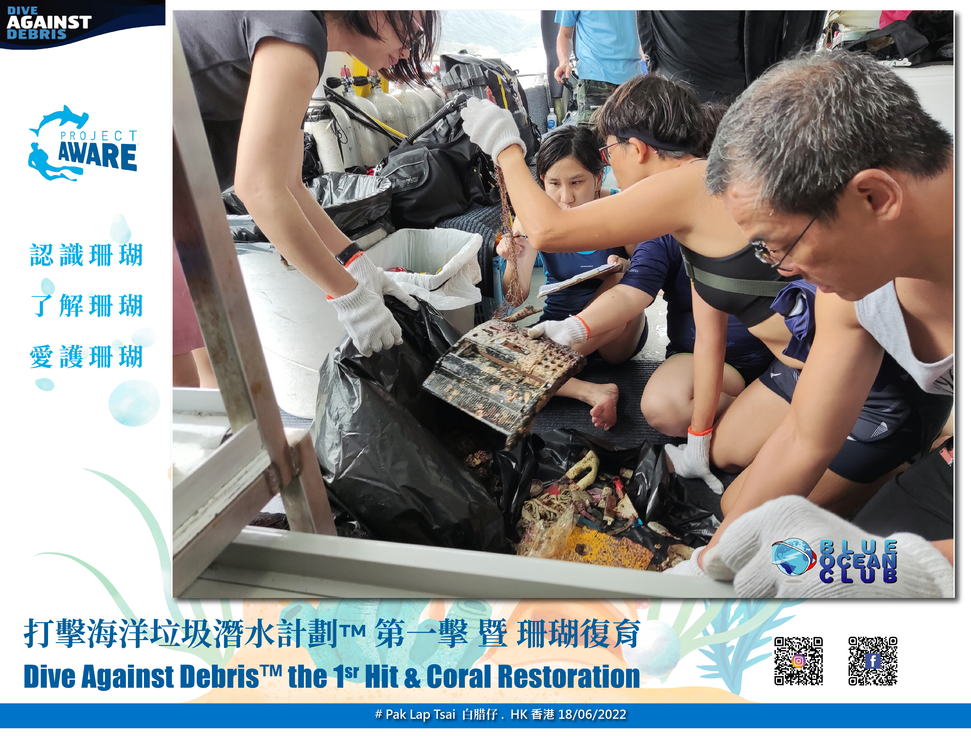
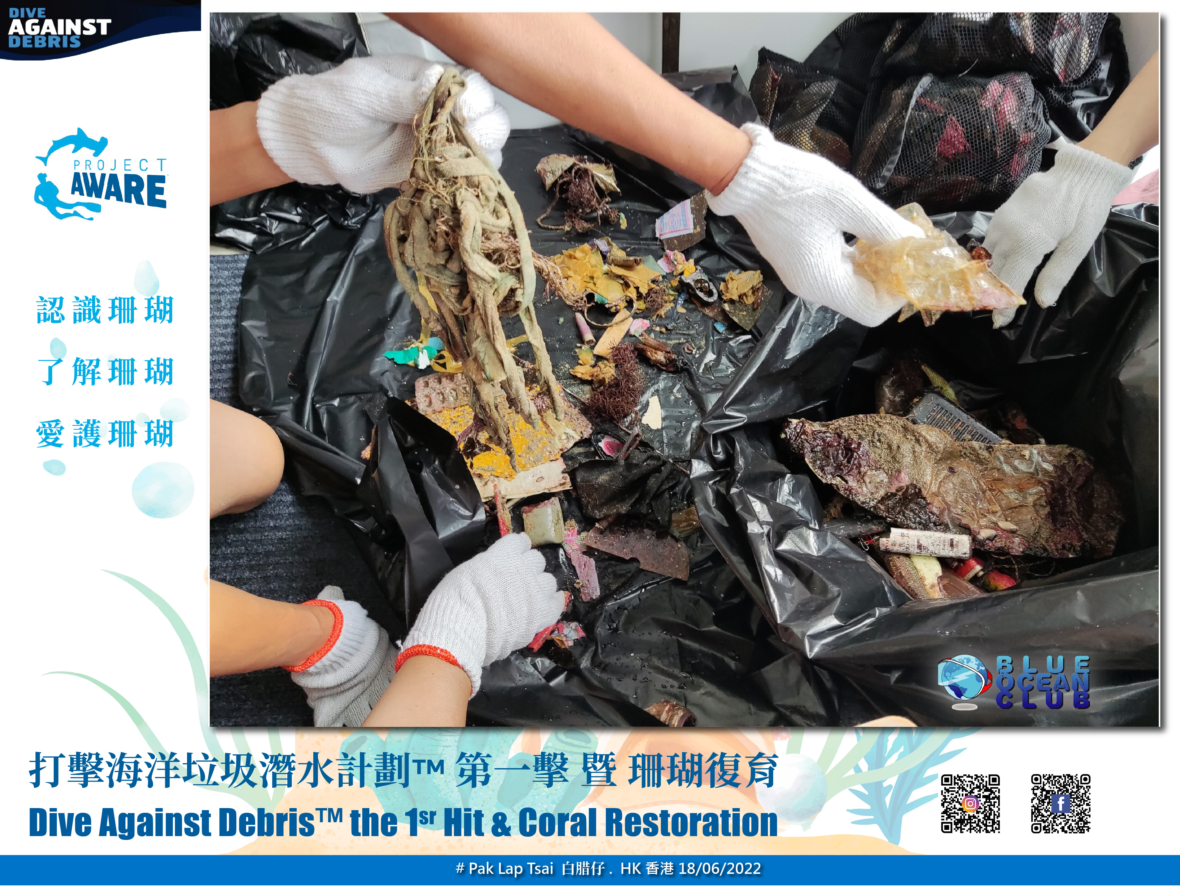
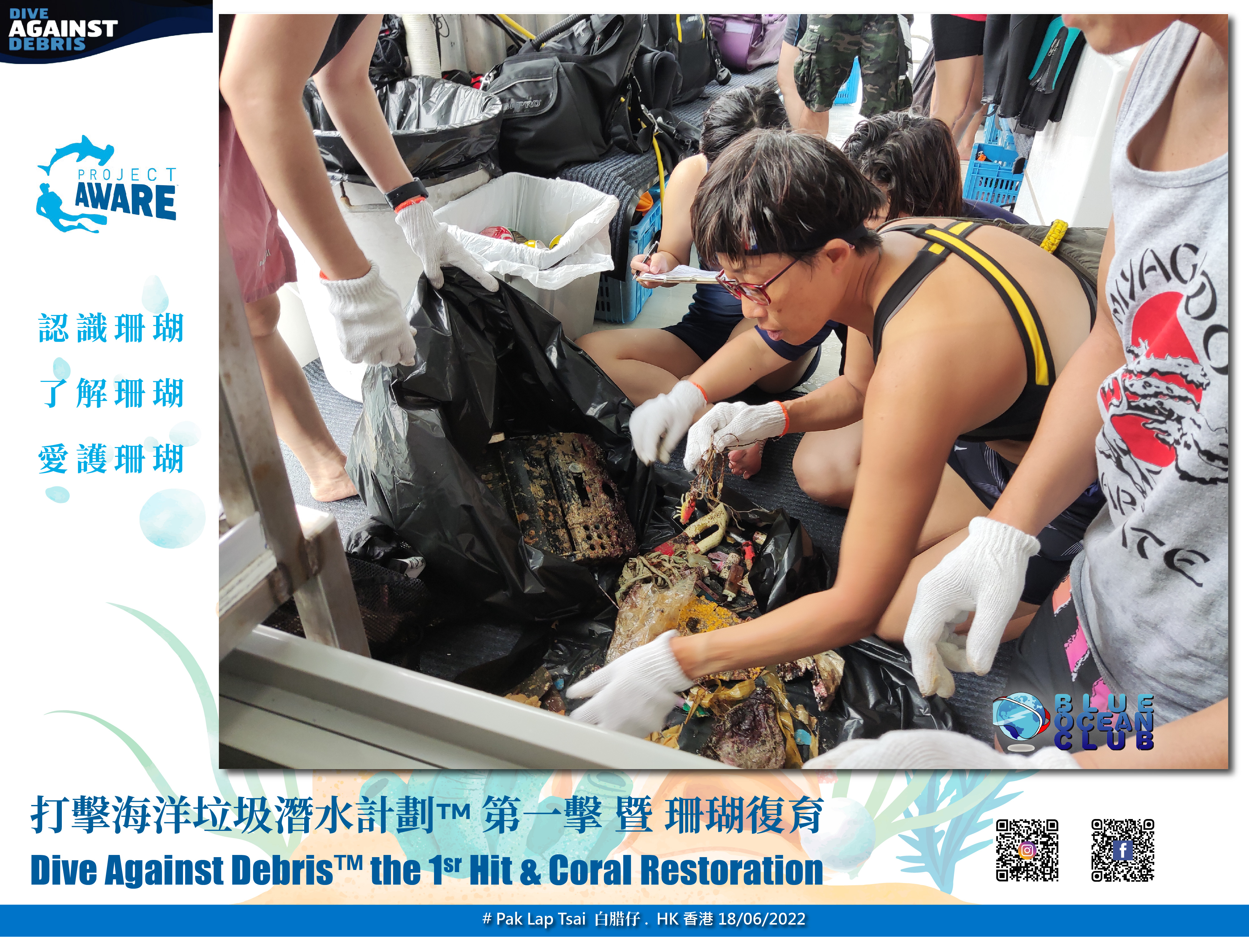
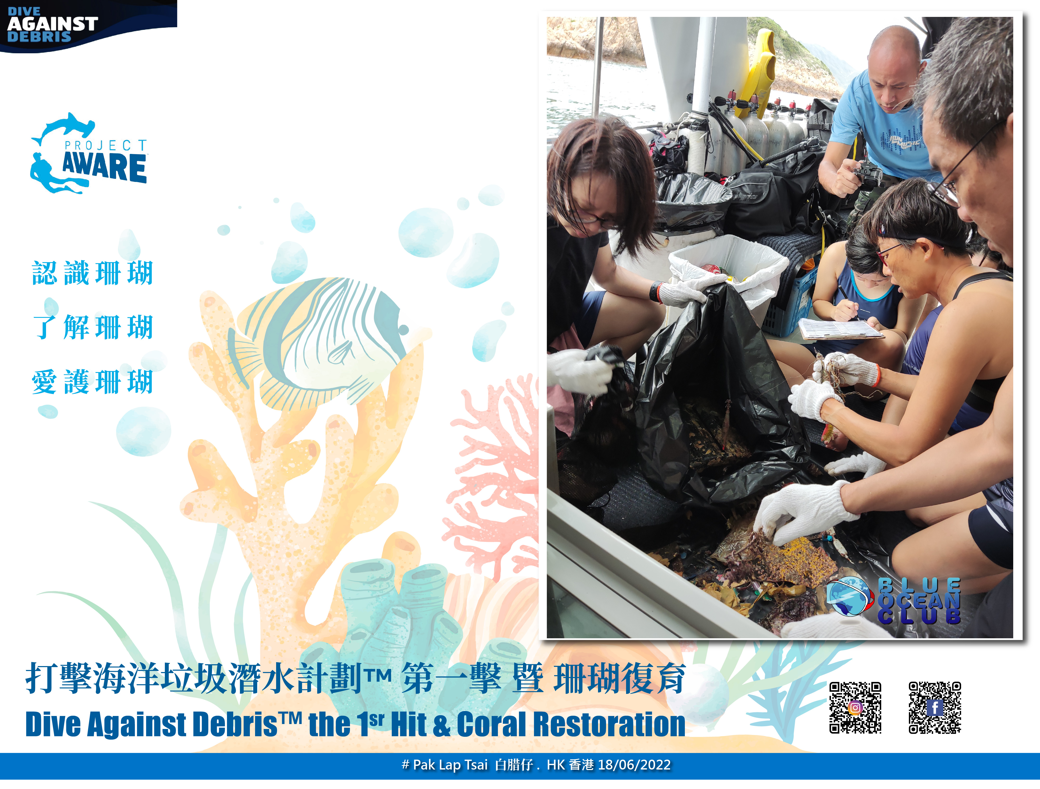
Most of the garbage was household garbage.
Among them, plastic waste accounted for the largest portion.
We have confirmed that a significant portion of the plastic waste we use goes into the sea.

To reduce plastic usage, we will use tumblers and stainless steel straws.
Unusual were umbrellas and camping chair legs.
Sunny
1
Umbrella
Time Space Dive
Hyungseok Kim
5
17
1
2
5
5
24
7
1
1
30.00
60
15.00
5.00
estimated
10909.10
Fishing Nets
Fishing Lures
Plastic Cup
On
kilograms
I have debris data to report
Smooth (wavelets) for waves 0.1 - 0.5 meter high
1
2
m2
meters
other
1
1
1
1
South Korea
State\Province
Seoul
City
Seoul
Map Help


Dive Location

If you know your survey site coordinates, enter them manually in decimal degrees using WGS84 Map Datum. Use the minus sign for latitudes south of the equator and longitudes west of the Prime Meridian to 180 degrees.

If you do not know your survey site coordinates, click the “Map Location” tab to use the map to zoom into your survey site and drop the pin on the map to fall within your survey dive site in the water (not on land or the beach). Ensure you zoom in as much as possible to ensure data accuracy.

Entangled Help


Use the vertical tabs below to record any entangled animals you found of each type.

Ecosystem Other
Sand

NAUTILUS DIVE CENTER ARUBA S27729

0
0
0
0

12.464422, -69.971501

0
0
0
sand
0
0
0
0
0
Mangel Halto Reef
Yes
Just 1 diver participate with me.
Beer bottles
Good
Nautilus DIVE center Aruba
Juan Mora
0
1
0
0
0
0
0
0
0
0
0
0
0
0
0
0
0
0
0
2
0
0
0
0
0
0
0
0
0
0
0
0
0
0
0
0
1.00
45
55.00
20.00
0
estimated
0
0
0
0
10000.00
0
0
0
0
0
Debris
0
On
pounds
0
I have debris data to report
0
0
0
Smooth (wavelets) for waves 0.1 - 0.5 meter high
0
0
0
0
0
0
0
ft2
0
0
feet
coral reef
0
0
0
0
0
0
0
0
0
0
0
0
0
0
0
0
0
0
0
0
0
0
0
0
0
0
0
0
0
Aruba
State\Province
Savaneta
City
Pos Chiquito
Map Help


Dive Location

If you know your survey site coordinates, enter them manually in decimal degrees using WGS84 Map Datum. Use the minus sign for latitudes south of the equator and longitudes west of the Prime Meridian to 180 degrees.

If you do not know your survey site coordinates, click the “Map Location” tab to use the map to zoom into your survey site and drop the pin on the map to fall within your survey dive site in the water (not on land or the beach). Ensure you zoom in as much as possible to ensure data accuracy.

Entangled Help


Use the vertical tabs below to record any entangled animals you found of each type.

Maliko Bay

0
0
0
0

20.937133, -156.340728

0
0
0
coral
0
0
0
30
0
No, but it's a local fishing spot
Several dozen feet of line wrapped around a turtle, especially the front left flipper. The turtle wasn't using the tangled flipper. The turtle approached us later in the dive, so we cut off the line that we could but were unable to free the flipper.
Men's swim trunks (deteriorated)
Sunny, minor swell, some rain the day before
Alex
0
0
2
0
0
0
0
0
0
0
0
0
0
0
0
0
0
0
0
2
0
0
0
0
0
0
0
0
0
0
0
0
1
0
0
0
5.00
104
59.00
15.00
0
estimated
0
0
0
3
60522.80
0
0
0
0
0
Fishing line
Fishing weights
Fishing debris
0
On
pounds
0
I have debris data to report
0
0
0
Smooth (wavelets) for waves 0.1 - 0.5 meter high
0
0
0
0
0
0
0
ft2
0
0
feet
coral reef
1
0
0
0
0
0
0
0
0
0
1
0
0
0
0
0
0
0
0
0
0
0
Fishing line
Injured
Green Sea Turtle
0
0
0
0
0
0
0
0
United States
State\Province
Hawaii
City
Haiku-Pauwela
Map Help


Dive Location

If you know your survey site coordinates, enter them manually in decimal degrees using WGS84 Map Datum. Use the minus sign for latitudes south of the equator and longitudes west of the Prime Meridian to 180 degrees.

If you do not know your survey site coordinates, click the “Map Location” tab to use the map to zoom into your survey site and drop the pin on the map to fall within your survey dive site in the water (not on land or the beach). Ensure you zoom in as much as possible to ensure data accuracy.

Entangled Help


Use the vertical tabs below to record any entangled animals you found of each type.

Frenchman’s Reef

0
0
0
0

18.020659344895, -63.090013844556

0
0
0
sand
0
0
0
3
0
Glass bottle bottom
Calm
SXM Coastal Clean Up
Jen Downey
0
0
0
0
0
0
0
0
0
0
0
0
0
0
0
0
0
0
0
9
0
0
0
0
0
0
0
0
0
0
0
0
0
0
0
0
2.00
35
25.00
20.00
0
estimated
0
3
132115.00
0
0
0
0
0
Fishing line, hooks, and weights
0
On
pounds
0
I have debris data to report
0
0
0
Slight for waves 0.5 -1.25 meter high
0
0
0
0
0
0
0
ft2
0
0
feet
rocky reef
0
0
0
0
0
0
0
0
0
0
0
0
0
0
0
0
0
0
0
0
0
0
2
0
0
0
0
0
0
Netherlands Antilles
Map Help


Dive Location

If you know your survey site coordinates, enter them manually in decimal degrees using WGS84 Map Datum. Use the minus sign for latitudes south of the equator and longitudes west of the Prime Meridian to 180 degrees.

If you do not know your survey site coordinates, click the “Map Location” tab to use the map to zoom into your survey site and drop the pin on the map to fall within your survey dive site in the water (not on land or the beach). Ensure you zoom in as much as possible to ensure data accuracy.

Entangled Help


Use the vertical tabs below to record any entangled animals you found of each type.

DROC-Los Cabezos

45

19.75778, -70.51851

sand
Regular
3
1
sanitary towel
Fiberglas parts
Divecenter Merlin
Christian Harder
2
6
4
2
12
3.00
63
7.00
2.50
estimated
3600.00
4
3
On
kilograms
I have debris data to report
Calm (glassy to rippled) for waves 0 – 0.1 meter high
9
m2
meters
coral reef
5
2
1
1
22
Dominican Republic
State\Province
Puerto Plata
City
Sosua
Map Help


Dive Location

If you know your survey site coordinates, enter them manually in decimal degrees using WGS84 Map Datum. Use the minus sign for latitudes south of the equator and longitudes west of the Prime Meridian to 180 degrees.

If you do not know your survey site coordinates, click the “Map Location” tab to use the map to zoom into your survey site and drop the pin on the map to fall within your survey dive site in the water (not on land or the beach). Ensure you zoom in as much as possible to ensure data accuracy.

Entangled Help


Use the vertical tabs below to record any entangled animals you found of each type.

DROC - Atlantic Princess

1

18.370917, -68.854444

coral
1
Dressel Divers Bayahibe
Carlo Veneruso
2
1
5
1.00
50
13.00
6.00
estimated
350.00
On
kilograms
I have debris data to report
Smooth (wavelets) for waves 0.1 - 0.5 meter high m2
meters
coral reef
Dominican Republic
State\Province
Altagracia
City
Higuey
Map Help


Dive Location

If you know your survey site coordinates, enter them manually in decimal degrees using WGS84 Map Datum. Use the minus sign for latitudes south of the equator and longitudes west of the Prime Meridian to 180 degrees.

If you do not know your survey site coordinates, click the “Map Location” tab to use the map to zoom into your survey site and drop the pin on the map to fall within your survey dive site in the water (not on land or the beach). Ensure you zoom in as much as possible to ensure data accuracy.

Entangled Help


Use the vertical tabs below to record any entangled animals you found of each type.

Hawk Channel Near Rattlesnake Key

0
9
0
14
2
0
0
seagrass
0
30
0
4
0

25.154170946799, -80.358065239261

We did find many old bathtubs persons placed underwater in the 11 - 14 feet deep seagrass bed floor for (lobster hotels) most likely used by poachers' year-round for illegal catching, but these had started to have sponge and coral growth. Also due to the pure weight of them, we could not remove these.
I do not believe anyone cleaned this area properly since Hurricane Irma 2017
We only covered in this half day about 1/10 of the area that needs cleaned here. We were limited on time due to a lightning storm we could see brewing a few miles to the NW of our location. We plan to return to this area a few more time and remove as much as possible.
Rhinestone studded high heel shoes.
Sunny, no wind, flat seas 84F Ocean temp.
Sail Fish Scuba
Christopher Kerr
3
4
0
0
0
0
0
1
0
0
0
1
0
0
0
0
36
0
22
0
0
1
0
6
2
14
1
8
2
6
1
1
0
0
2
1500.00
119
14.00
1.00
20
estimated
2
0
0
4
300.00
0
2
0
2
0
Heavy 20" round PVC Sewer pipe
Very Huge Long Line fishing netting - hundreds of pounds
Lobster and Crab trap long lines with foam floats, we collected hundreds of feet.
0
On
pounds
0
I have debris data to report
2
4
0
Calm (glassy to rippled) for waves 0 – 0.1 meter high
4
0
2
stuck in plastic trap
Crabs and Lobsters
Released Unharmed
4
2
4
3
0
ft2
20
2
feet
seagrass
1
0
2
0
0
0
1
0
1
5
0
0
1
0
0
2
0
4
0
0
0
0
4
0
0
0
0
1
0
United States
State\Province
Florida
City
Key Largo
Map Help


Dive Location

If you know your survey site coordinates, enter them manually in decimal degrees using WGS84 Map Datum. Use the minus sign for latitudes south of the equator and longitudes west of the Prime Meridian to 180 degrees.

If you do not know your survey site coordinates, click the “Map Location” tab to use the map to zoom into your survey site and drop the pin on the map to fall within your survey dive site in the water (not on land or the beach). Ensure you zoom in as much as possible to ensure data accuracy.

Entangled Help


Use the vertical tabs below to record any entangled animals you found of each type.

DROC - The Aquarium

18.538912, -68.347941

1
coral
1
N/A
sunny, calm
SeaPro Divers
Jennifer Vitali
1
3
1
1.00
30
8.00
2.00
estimated
200.00
fishing line
On
kilograms
I have debris data to report
Smooth (wavelets) for waves 0.1 - 0.5 meter high m2
meters
coral reef
Dominican Republic
State\Province
La Altagracia
City
Bavaro/Punta cana
Map Help


Dive Location

If you know your survey site coordinates, enter them manually in decimal degrees using WGS84 Map Datum. Use the minus sign for latitudes south of the equator and longitudes west of the Prime Meridian to 180 degrees.

If you do not know your survey site coordinates, click the “Map Location” tab to use the map to zoom into your survey site and drop the pin on the map to fall within your survey dive site in the water (not on land or the beach). Ensure you zoom in as much as possible to ensure data accuracy.

Entangled Help


Use the vertical tabs below to record any entangled animals you found of each type.

DROC - The Aquarium

1

18.538912, -68.347941

coral
N/A
sunny, calm
seapro Divers
Jennifer Vitali
1
4
0.50
45
11.00
2.00
estimated
250.00
1
On
kilograms
I have debris data to report
Calm (glassy to rippled) for waves 0 – 0.1 meter high m2
meters
coral reef
Dominican Republic
State\Province
La Altagracia
City
Bavaro/Punta Cana
Map Help


Dive Location

If you know your survey site coordinates, enter them manually in decimal degrees using WGS84 Map Datum. Use the minus sign for latitudes south of the equator and longitudes west of the Prime Meridian to 180 degrees.

If you do not know your survey site coordinates, click the “Map Location” tab to use the map to zoom into your survey site and drop the pin on the map to fall within your survey dive site in the water (not on land or the beach). Ensure you zoom in as much as possible to ensure data accuracy.

Entangled Help


Use the vertical tabs below to record any entangled animals you found of each type.

Pak Lap Tsai 白腊仔

20
rock
1
17
3
1

22.352615305151, 114.36562406311

Joss Paper
Mainly cloudy with a few showers. Isolated thunderstorms in the morning. Sunny intervals during the day.
BLUE OCEAN CLUB HONG KONG
EIAN KEE
1
4
1
8
35
11
10.00
60
10.00
1.00
4
measured
13
1000.00
On
kilograms
I have debris data to report
Calm (glassy to rippled) for waves 0 – 0.1 meter high
1
1
4
1
m2
4
meters
rocky reef
5
65
1
Hong Kong S.A.R., China
Map Help


Dive Location

If you know your survey site coordinates, enter them manually in decimal degrees using WGS84 Map Datum. Use the minus sign for latitudes south of the equator and longitudes west of the Prime Meridian to 180 degrees.

If you do not know your survey site coordinates, click the “Map Location” tab to use the map to zoom into your survey site and drop the pin on the map to fall within your survey dive site in the water (not on land or the beach). Ensure you zoom in as much as possible to ensure data accuracy.

Entangled Help


Use the vertical tabs below to record any entangled animals you found of each type.

Subscribe to