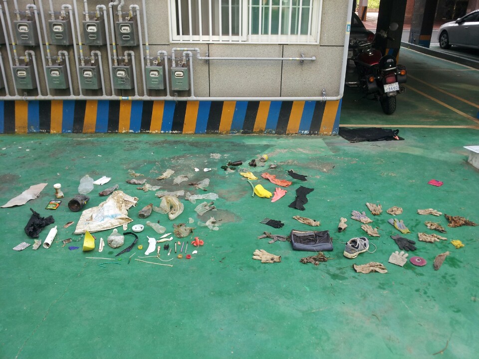
The area around the pipes I had been cutting massive fishing nets/ropes from earlier in the spring seemed to have cleared up and is now no longer covered by sand. I didn't have my knife with me on this survey, but on the next trip be able to once again clear some of that debris.
Seems to be an an over-abundance of gloves. Alot of the trash seemed to be older than usual, and I guess much of it was turned up by the typhoon last week
The leg portion of some type of heavy rubber suit
Mostly clear. Category 1-2 typhoon hit the area a week ago
1
1
flashlight w/ battery
Lobster Toy
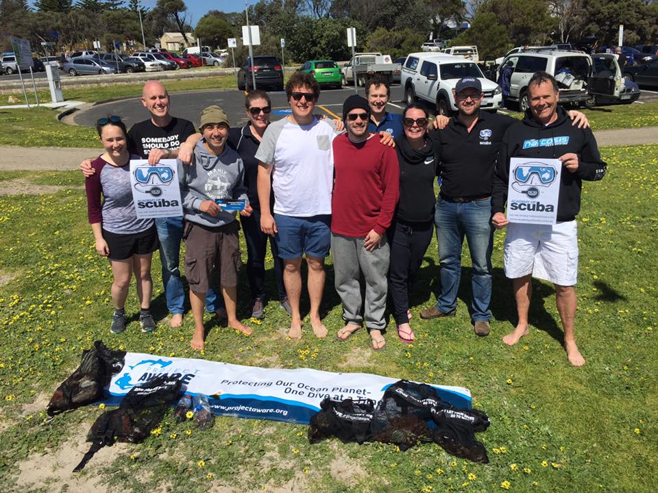
Dive Against Debris Korea (Daegu)
William Henderson
1
1
1
3
3
2
4
1
14.00
52
4.00
0.50
estimated
112.00
4
4
cloth gloves
plastic gloves
On
kilograms
I have debris data to report
1
Calm (glassy to rippled) for waves 0 – 0.1 meter high
1
1
5
16
m2
6
meters
rocky reef
3
1
2
5
South Korea
State\Province
Gyeongsang-bukdo
City
Pohang
Map Help
Dive Location
If you know your survey site coordinates, enter them manually in decimal degrees using WGS84 Map Datum. Use the minus sign for latitudes south of the equator and longitudes west of the Prime Meridian to 180 degrees.
If you do not know your survey site coordinates, click the “Map Location” tab to use the map to zoom into your survey site and drop the pin on the map to fall within your survey dive site in the water (not on land or the beach). Ensure you zoom in as much as possible to ensure data accuracy.
Entangled Help
Use the vertical tabs below to record any entangled animals you found of each type.
Calm (glassy to rippled) for waves 0 – 0.1 meter high
m2
meters
seagrass
3
1
Language
English
Greece
State\Province
Samos
City
Samos
Map Help
Dive Location
If you know your survey site coordinates, enter them manually in decimal degrees using WGS84 Map Datum. Use the minus sign for latitudes south of the equator and longitudes west of the Prime Meridian to 180 degrees.
If you do not know your survey site coordinates, click the “Map Location” tab to use the map to zoom into your survey site and drop the pin on the map to fall within your survey dive site in the water (not on land or the beach). Ensure you zoom in as much as possible to ensure data accuracy.
Entangled Help
Use the vertical tabs below to record any entangled animals you found of each type.
No, this was during an Open Water Diver course that I picked up the reported debris.
Andark lake is a manmade diving/training facility. It is very clean and full of insect life and plants. No fish reported yet. The lake is about 3 years old. As it is maintained really well, it was surprising to find any debris at all.
Golfbal
Andark
Margriet Schuur
3
4
1
1.00
22
7.00
4.00
estimated
200.00
On
kilograms
I have debris data to report
Calm (glassy to rippled) for waves 0 – 0.1 meter high
m2
meters
other
Language
English
United Kingdom
City
Southampton
Map Help
Dive Location
If you know your survey site coordinates, enter them manually in decimal degrees using WGS84 Map Datum. Use the minus sign for latitudes south of the equator and longitudes west of the Prime Meridian to 180 degrees.
If you do not know your survey site coordinates, click the “Map Location” tab to use the map to zoom into your survey site and drop the pin on the map to fall within your survey dive site in the water (not on land or the beach). Ensure you zoom in as much as possible to ensure data accuracy.
Entangled Help
Use the vertical tabs below to record any entangled animals you found of each type.
This dive site has been adopted by the local dive centre and is very clean already.
No, I remove debris on every dive I do if appropriate (as long as no marine life has started living in it).
Andark
Margriet Schuur
3
1.00
48
19.00
5.00
estimated
20.00
On
kilograms
I have debris data to report
Calm (glassy to rippled) for waves 0 – 0.1 meter high
m2
meters
other
Language
English
United Kingdom
City
Southampton
Map Help
Dive Location
If you know your survey site coordinates, enter them manually in decimal degrees using WGS84 Map Datum. Use the minus sign for latitudes south of the equator and longitudes west of the Prime Meridian to 180 degrees.
If you do not know your survey site coordinates, click the “Map Location” tab to use the map to zoom into your survey site and drop the pin on the map to fall within your survey dive site in the water (not on land or the beach). Ensure you zoom in as much as possible to ensure data accuracy.
Entangled Help
Use the vertical tabs below to record any entangled animals you found of each type.
Heavy rain 2 days prior, slight rain day of survey. STRONG currents.
7Seas Dive Gili
Renee Street
1
2
13
4
4
1
23.50
27
17.60
15.00
2
measured
7500.00
Plastic Fragments
Plastic Food Wrappers
Burlap Bags
On
kilograms
I have debris data to report
Slight for waves 0.5 -1.25 meter high
1
10
18
m2
2
meters
coral reef
1
1
3
Language
English
Indonesia
State\Province
Lombok
City
Gili Air
Map Help
Dive Location
If you know your survey site coordinates, enter them manually in decimal degrees using WGS84 Map Datum. Use the minus sign for latitudes south of the equator and longitudes west of the Prime Meridian to 180 degrees.
If you do not know your survey site coordinates, click the “Map Location” tab to use the map to zoom into your survey site and drop the pin on the map to fall within your survey dive site in the water (not on land or the beach). Ensure you zoom in as much as possible to ensure data accuracy.
Entangled Help
Use the vertical tabs below to record any entangled animals you found of each type.
Calm (glassy to rippled) for waves 0 – 0.1 meter high
1
Plastic Bag
crab
Dead
2
1
3
m2
meters
coral reef
1
1
2
3
19
1
Language
English
Indonesia
State\Province
Lombok
City
Gili Air
Map Help
Dive Location
If you know your survey site coordinates, enter them manually in decimal degrees using WGS84 Map Datum. Use the minus sign for latitudes south of the equator and longitudes west of the Prime Meridian to 180 degrees.
If you do not know your survey site coordinates, click the “Map Location” tab to use the map to zoom into your survey site and drop the pin on the map to fall within your survey dive site in the water (not on land or the beach). Ensure you zoom in as much as possible to ensure data accuracy.
Entangled Help
Use the vertical tabs below to record any entangled animals you found of each type.
less rubbish due to strong winds, dead seagrass covered plastic items
Large plastic bucket
Strong winds (25 knots)
1
Metal sheet
AIDC
Lucy Martin
1
6
2
2.00
40
5.00
1.00
measured
10
1647.00
Fishing line
Fishing net
Plastic items
On
kilograms
I have debris data to report
Slight for waves 0.5 -1.25 meter high
2
1
m2
meters
coral reef
Language
English
Seychelles
State\Province
Outer Islands
City
Alphonse Island
Map Help
Dive Location
If you know your survey site coordinates, enter them manually in decimal degrees using WGS84 Map Datum. Use the minus sign for latitudes south of the equator and longitudes west of the Prime Meridian to 180 degrees.
If you do not know your survey site coordinates, click the “Map Location” tab to use the map to zoom into your survey site and drop the pin on the map to fall within your survey dive site in the water (not on land or the beach). Ensure you zoom in as much as possible to ensure data accuracy.
Entangled Help
Use the vertical tabs below to record any entangled animals you found of each type.
Metodología
Para la realización del proyecto se ha dividido la metodología en dos etapas: Planeación e Intervención. En las dos etapas que incluyen jornadas de buceo, cada buzo cuenta con el equipo básico de buceo que incluye careta, snorkel, aletas, botines, traje, chaleco, regulador, lastre y tanque. Dichos equipos son alquilados en los diferentes centros de buceo que pertenecen a la iniciativa con el fin de poder dotar al equipo de trabajo para las jornadas. Cada participante es además cubierto por el seguro de buceo que cubre a los buzos en sus inmersiones ante cualquier accidente o eventualidad si llegase a presentarse.
Texto: Alexandra Pineda Muñoz ( Seaflower Research and Conservation Foundation)
Con el fin de darle solución a dicha problemática, la Gobernación del Departamento Archipiélago de San Andrés, Providencia y Santa Catalina crea un convenio de asociación con la Fundación Help 2 Oceans, para crear el proyecto Buscando Soluciones de Fondo. Dicha propuesta apoyará cuatro jornadas de limpieza del proyecto Iniciativa Bajo Tranquilo, con el fin de limpiar y recuperar ecosistemas marinos afectados por residuos sólidos sumergidos mediante la educación con soportes científicos y la participación ciudadana. El proyecto vincula buzos recreativos (locales y turistas), y no buzos acompañantes en actividades vivenciales en los espacios estratégicos submarinos por medio de jornadas de limpieza, generando identidad hacia el contexto ambiental local, regional y nacional, con sentido de pertenencia, solidaridad y tolerancia como herramientas de desarrollo de competencias de pensamiento científico y ciudadano. Este proyecto trabaja, mediante la participación ciudadana, la recuperación de ecosistemas afectados por la contaminación de residuos sólidos sumergidos (RSS) y vincula a la comunidad local y turística para trabajar conjuntamente por una sola causa. Texto: Alexandra Pineda Muñoz ( Seaflower Research and Conservation Foundation)
Implementar estrategia de educación ambiental para fortalecer la pedagogía frente a los riesgos asociados a la contaminación de los ecosistemas marinos o una campaña de prevención para evitar que la problemática de contaminación por residuos sólidos sumergidos continúe.
Texto: Alexandra Pineda Muñoz ( Seaflower Research and Conservation Foundation)
tela
El residuo que predominó fueron las botellas de vidrio de tipo envases, tanto de gaseosa como de cerveza. Consideramos que dicho resultado se debe a la poca educación ambiental que hay en la isla, tanto entre los turistas como residentes, y que el origen de dichos desechos es el estadero Big Mamma, el cual a sus alrededores presenta gran cantidad de desechos, los cuales con los vientos y subida de marea terminan resultando en el mar.
Adicionalmente se identificó que fue abundante la presencia de nylon enredado entre los corales y esponjas. Dichos residuos son el resultado de líneas de pesca abandonadas, las cuales son usadas para pescar, pero son abandonadas una vez se enredan con el fondo marino. La mayoría de las líneas de pesca extraídas presentaban anzuelos, y bujías y otros objetos metálicos como pesas sujetas a ellas, por lo cual se consideran altamente contaminantes para el medio marino. Las líneas de pesca abandonadas, o líneas fantasmas como se conocen, resultan una de las mayores amenazas al medio marino, ya que por si poca visibilidad las especies tienden a sufrir enredos en ellos y tienden a causar la muerte de los mismos, por lo cual se hace imprescindible extraerlas del mismo. La presencia de residuos grandes y pesados como los cilindros, tubos, ollas y la silla, demuestran además que las personas de la isla continúan arrojando los escombros y desechos al fondo marino para deshacerse de ellos, y demuestra la necesidad de realizar mayores campañas educativas en la comunidad. Texto: Alexandra Pineda Muñoz ( Seaflower Research and Conservation Foundation)
Buenas
HELP 2 OCEANS FOUNDATION
Jorge H. Sanchez
17
231.00
50
12.00
1.00
estimated
200
9000.00
3
On
kilograms
I have debris data to report
121
Calm (glassy to rippled) for waves 0 – 0.1 meter high
4
camarones
camaron
Released Unharmed
189
Released Unharmed
25
m2
6
meters
coral reef
57
5
2
12
12
52
3
Language
English
Colombia
City
San Andres, Isla
Map Help
Dive Location
If you know your survey site coordinates, enter them manually in decimal degrees using WGS84 Map Datum. Use the minus sign for latitudes south of the equator and longitudes west of the Prime Meridian to 180 degrees.
If you do not know your survey site coordinates, click the “Map Location” tab to use the map to zoom into your survey site and drop the pin on the map to fall within your survey dive site in the water (not on land or the beach). Ensure you zoom in as much as possible to ensure data accuracy.
Entangled Help
Use the vertical tabs below to record any entangled animals you found of each type.
The debris on the pier is simply the result of negligent fishermen, and the general public, who treat the beach like a giant rubbish bin - disgraceful!
Part of the pier, which was blown off months ago during a nasty storm, and which was still sitting, sharp side up, in an area that children play in during the summer months
Windy, butter generally dry
Academy of Scuba
Oliver Payne
1
5
10
20
10
13.00
60
6.00
2.00
10
measured
15
3000.00
The part of the pier landing
Squid jigs
Oil can
On
kilograms
I have debris data to report
25
Smooth (wavelets) for waves 0.1 - 0.5 meter high
5
m2
meters
other
20
5
2
20
15
Language
English
Australia
State\Province
Victoria
City
Melbourne
Map Help
Dive Location
If you know your survey site coordinates, enter them manually in decimal degrees using WGS84 Map Datum. Use the minus sign for latitudes south of the equator and longitudes west of the Prime Meridian to 180 degrees.
If you do not know your survey site coordinates, click the “Map Location” tab to use the map to zoom into your survey site and drop the pin on the map to fall within your survey dive site in the water (not on land or the beach). Ensure you zoom in as much as possible to ensure data accuracy.
Entangled Help
Use the vertical tabs below to record any entangled animals you found of each type.