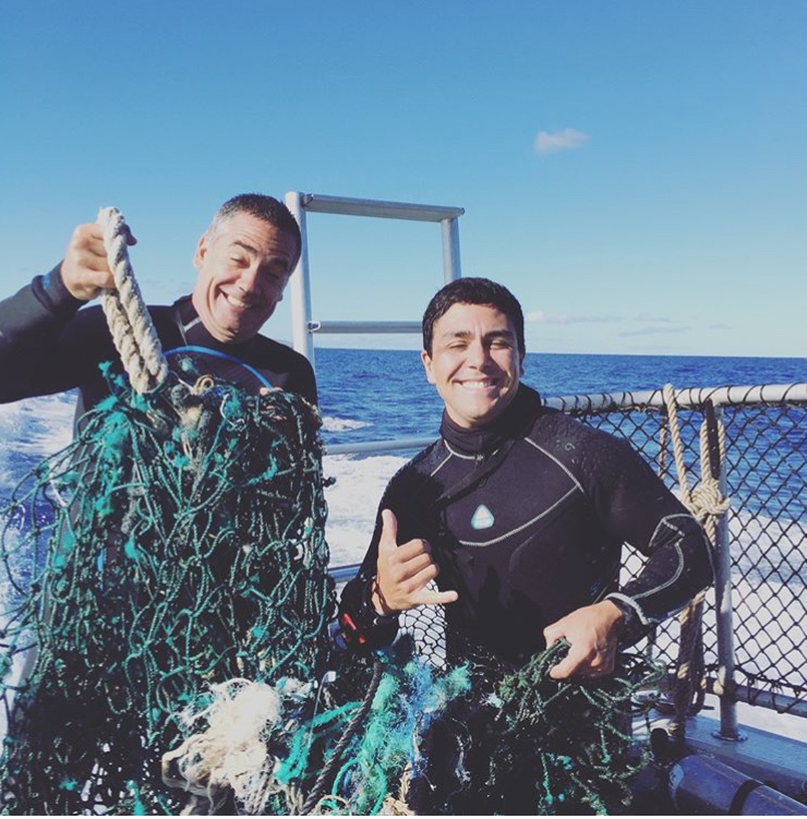
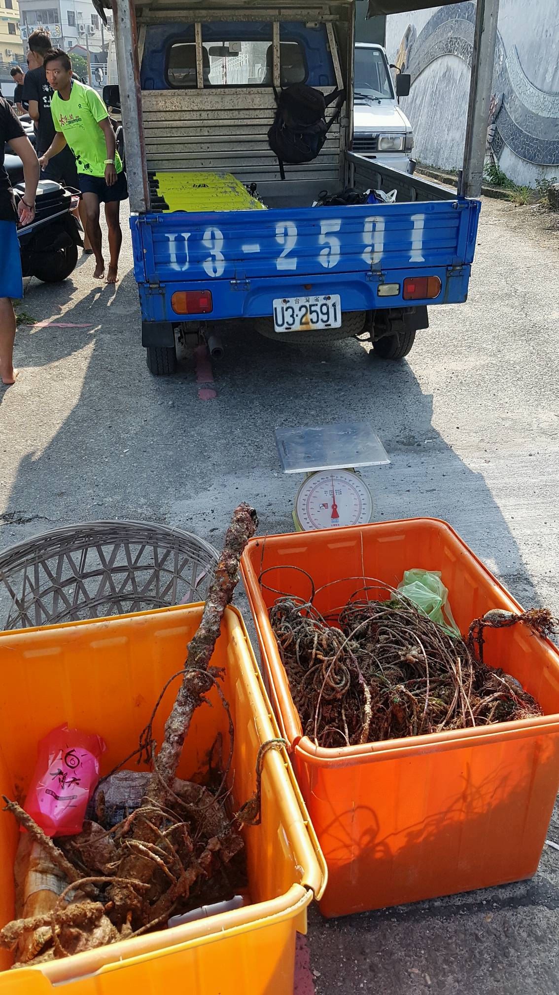
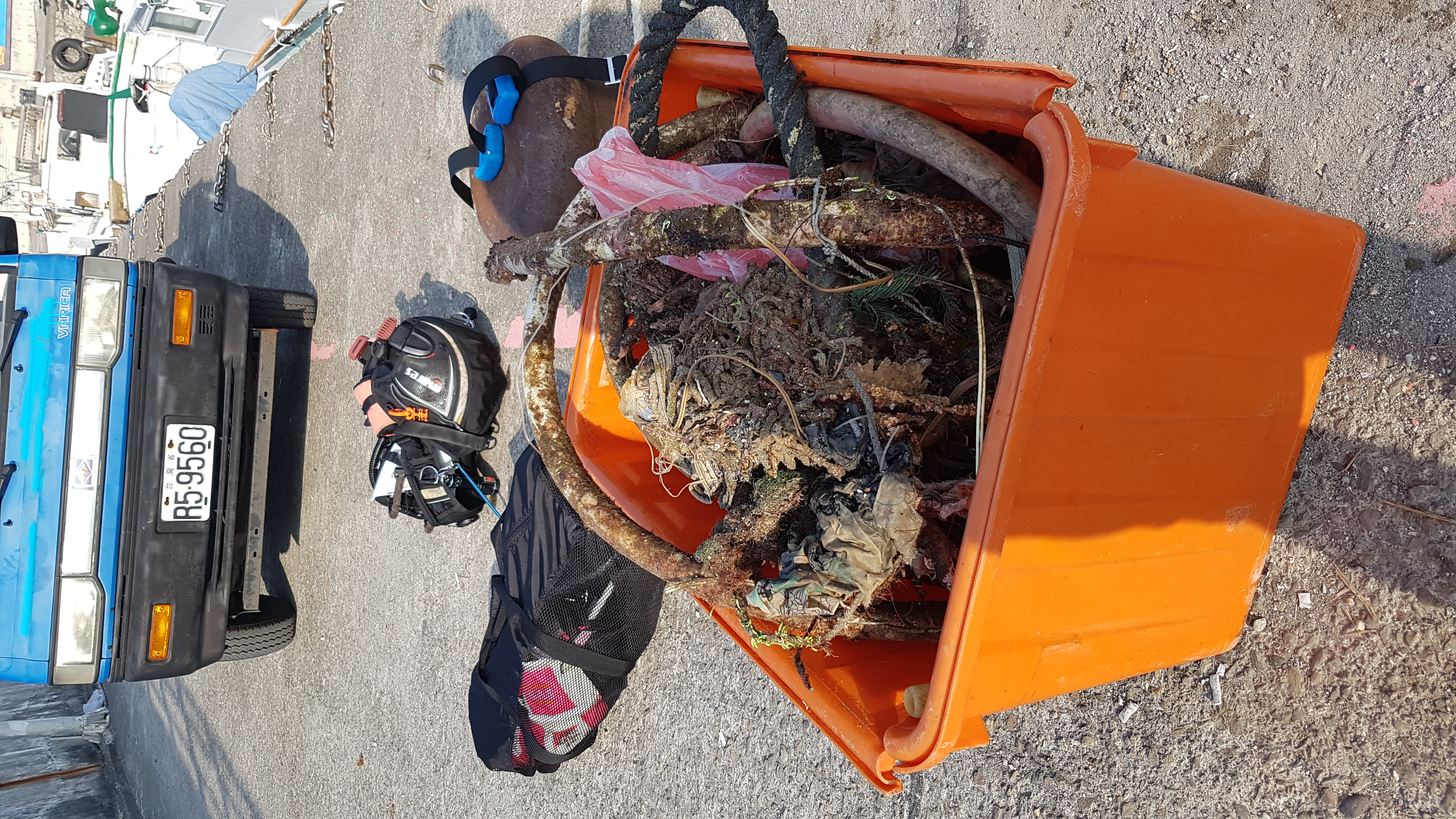
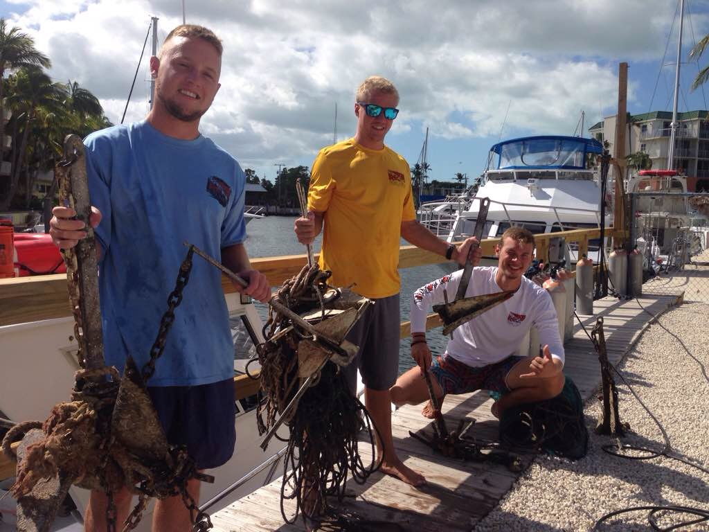
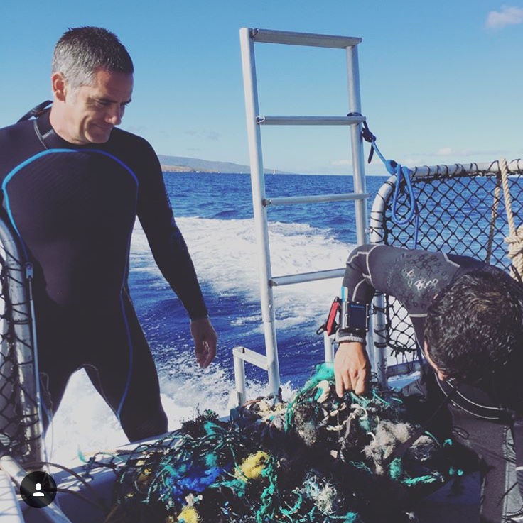
we were looking for debris when on the way back to the harbor we found this enormous net with severals frogfish and crabs trap i between the net, you will see on the photos.
Fisherman in Maui at least they need to have more concern what the thing they trough to the ocean, for an example if you seeing a guy throwing a cigarette always the same answer from a few of them the ocean is too big, why you care so much about it?.
its sad to seeing very frequently more and more debris floating on the ocean, and more frequently are fishing nets. sorry for my English I hope this it can be understandable.
escellent
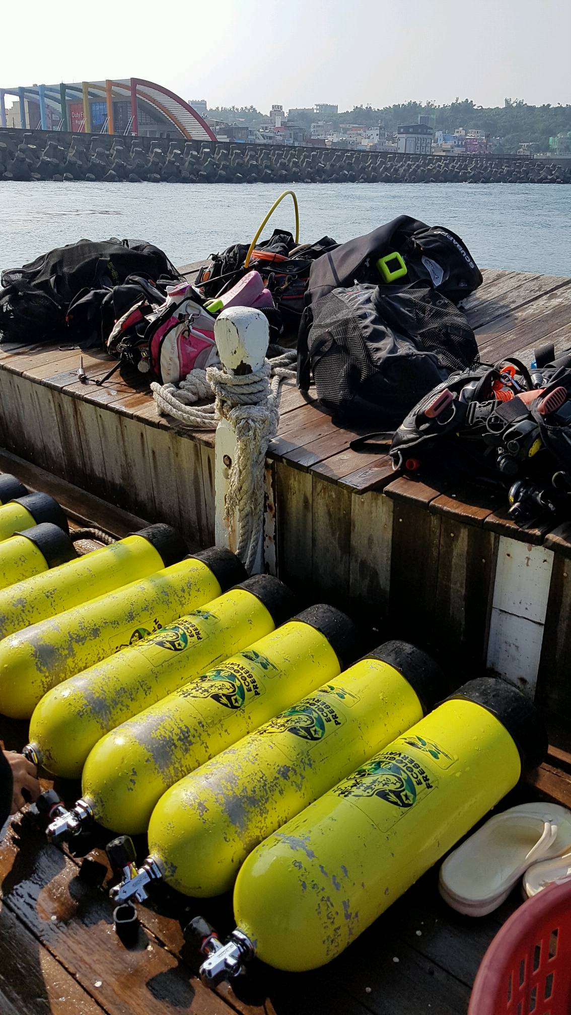
Makena coast dive charter
Gonzalo Berrios
4
3
1
8
3
45.00
60
60.00
30.00
estimated
2
4
1.00
1
On
pounds
2
I have debris data to report
Calm (glassy to rippled) for waves 0 – 0.1 meter high
frogfish on a fishing net
6
Released Unharmed
frog fishs
ft2
feet
coral reef
2
3
United States
State\Province
hawaii
City
kihei
Map Help
Dive Location
If you know your survey site coordinates, enter them manually in decimal degrees using WGS84 Map Datum. Use the minus sign for latitudes south of the equator and longitudes west of the Prime Meridian to 180 degrees.
If you do not know your survey site coordinates, click the “Map Location” tab to use the map to zoom into your survey site and drop the pin on the map to fall within your survey dive site in the water (not on land or the beach). Ensure you zoom in as much as possible to ensure data accuracy.
Entangled Help
Use the vertical tabs below to record any entangled animals you found of each type.
Calm (glassy to rippled) for waves 0 – 0.1 meter high
m2
meters
rocky reef
2
Language
English
Thailand
City
Phuket
Map Help
Dive Location
If you know your survey site coordinates, enter them manually in decimal degrees using WGS84 Map Datum. Use the minus sign for latitudes south of the equator and longitudes west of the Prime Meridian to 180 degrees.
If you do not know your survey site coordinates, click the “Map Location” tab to use the map to zoom into your survey site and drop the pin on the map to fall within your survey dive site in the water (not on land or the beach). Ensure you zoom in as much as possible to ensure data accuracy.
Entangled Help
Use the vertical tabs below to record any entangled animals you found of each type.
We cleared as much as we could safely lift to the surface. There is still lots to remove.
Caught in net. Believed dead but released in hope.
1
Electric cable
Khao Lak Scuba Adventures
Rianne Poesse
0
1
0
0
0
0
0
0
0
0
0
0
0
0
0
0
0
0
0
2
0
0
0
0
0
0
0
0
0
0
0
0
0
0
0
0
20.00
40
18.00
16.00
0
estimated
0
3
0
6
300.00
0
0
0
0
0
The sheer amount of nylon fishing net.
0
On
kilograms
0
I have debris data to report
0
0
0
Smooth (wavelets) for waves 0.1 - 0.5 meter high
0
0
0
0
0
4
0
1
m2
3
0
3
Fishing net
Conch
Dead
meters
other
0
0
0
0
0
0
0
0
0
0
0
0
0
0
0
0
0
0
0
0
0
0
0
0
0
0
0
0
0
Language
English
Thailand
State\Province
Phang Nga
City
Takua Pa
Map Help
Dive Location
If you know your survey site coordinates, enter them manually in decimal degrees using WGS84 Map Datum. Use the minus sign for latitudes south of the equator and longitudes west of the Prime Meridian to 180 degrees.
If you do not know your survey site coordinates, click the “Map Location” tab to use the map to zoom into your survey site and drop the pin on the map to fall within your survey dive site in the water (not on land or the beach). Ensure you zoom in as much as possible to ensure data accuracy.
Entangled Help
Use the vertical tabs below to record any entangled animals you found of each type.
Weather: Sunny
Water Temp: 29'C
Current: Strong
Visibility: 10M
Diving Bee marine house
Kris
14
35.00
50
12.00
10.00
measured
1100.00
On
kilograms
I have debris data to report
Smooth (wavelets) for waves 0.1 - 0.5 meter high
m2
meters
coral reef
Language
English
Taiwan
City
Xiao Liu Chiu Island
Map Help
Dive Location
If you know your survey site coordinates, enter them manually in decimal degrees using WGS84 Map Datum. Use the minus sign for latitudes south of the equator and longitudes west of the Prime Meridian to 180 degrees.
If you do not know your survey site coordinates, click the “Map Location” tab to use the map to zoom into your survey site and drop the pin on the map to fall within your survey dive site in the water (not on land or the beach). Ensure you zoom in as much as possible to ensure data accuracy.
Entangled Help
Use the vertical tabs below to record any entangled animals you found of each type.
Most of these items look like items that would of been lost by divers
Fork and Knife
Lots of rain, prevailing winds from the east
Fantasy Island Dive Center
Christopher Willey
2
1
5
5.00
45
70.00
15.00
estimated
2000.00
Snorkels
Plastic bags are but none where found this dive
On
pounds
I have debris data to report
Smooth (wavelets) for waves 0.1 - 0.5 meter high
1
ft2
feet
coral reef
2
1
Language
English
Honduras
State\Province
Roatan
City
French Harbor
Map Help
Dive Location
If you know your survey site coordinates, enter them manually in decimal degrees using WGS84 Map Datum. Use the minus sign for latitudes south of the equator and longitudes west of the Prime Meridian to 180 degrees.
If you do not know your survey site coordinates, click the “Map Location” tab to use the map to zoom into your survey site and drop the pin on the map to fall within your survey dive site in the water (not on land or the beach). Ensure you zoom in as much as possible to ensure data accuracy.
Entangled Help
Use the vertical tabs below to record any entangled animals you found of each type.
There was very bad weather, storms, heavy rain and strong winds which perhaps blew things into the water
nappy/diaper
Stormy weather, rain and wind
Buddha View Dive Shop
Jenni Simmons
1
1
27
3
18
1
2
21
1
6
2
230
30
1
1
1
1
20.50
60
10.00
1.50
77
measured
500.00
6
3
fishing line, nets and ropes
plastic bags/food containers
On
kilograms
I have debris data to report
11
Smooth (wavelets) for waves 0.1 - 0.5 meter high
2
7
9
m2
3
2
meters
coral reef
1
2
1
2
2
Language
English
Thailand
State\Province
Surat Thani
City
Chalok, Koh Tao
Map Help
Dive Location
If you know your survey site coordinates, enter them manually in decimal degrees using WGS84 Map Datum. Use the minus sign for latitudes south of the equator and longitudes west of the Prime Meridian to 180 degrees.
If you do not know your survey site coordinates, click the “Map Location” tab to use the map to zoom into your survey site and drop the pin on the map to fall within your survey dive site in the water (not on land or the beach). Ensure you zoom in as much as possible to ensure data accuracy.
Entangled Help
Use the vertical tabs below to record any entangled animals you found of each type.
Playing card - we have been finding playing cards in every clean up dive for more than one year now!
Windy and rainy, frequent downpours mixed with sunny spells. The season is currently changing in the Maldives so the weather is unpredictable.
Best Dives Vittaveli
Vivien/Emily
7
7
11
1
8
2
8.80
45
25.00
3.00
measured
10000.00
Tobacco Packaging
Fishing line
On
kilograms
I have debris data to report
Smooth (wavelets) for waves 0.1 - 0.5 meter high
3
1
3
m2
meters
coral reef
6
1
2
30
Language
English
Maldives
State\Province
Bolifushi
Map Help
Dive Location
If you know your survey site coordinates, enter them manually in decimal degrees using WGS84 Map Datum. Use the minus sign for latitudes south of the equator and longitudes west of the Prime Meridian to 180 degrees.
If you do not know your survey site coordinates, click the “Map Location” tab to use the map to zoom into your survey site and drop the pin on the map to fall within your survey dive site in the water (not on land or the beach). Ensure you zoom in as much as possible to ensure data accuracy.
Entangled Help
Use the vertical tabs below to record any entangled animals you found of each type.
Calm (glassy to rippled) for waves 0 – 0.1 meter high
0
0
0
0
0
0
0
m2
0
0
meters
coral reef
0
0
0
0
0
0
0
0
0
0
0
0
0
0
0
0
0
0
0
0
0
0
0
0
0
0
0
0
Language
English
Thailand
State\Province
Phuket
City
Patong
Map Help
Dive Location
If you know your survey site coordinates, enter them manually in decimal degrees using WGS84 Map Datum. Use the minus sign for latitudes south of the equator and longitudes west of the Prime Meridian to 180 degrees.
If you do not know your survey site coordinates, click the “Map Location” tab to use the map to zoom into your survey site and drop the pin on the map to fall within your survey dive site in the water (not on land or the beach). Ensure you zoom in as much as possible to ensure data accuracy.
Entangled Help
Use the vertical tabs below to record any entangled animals you found of each type.
Calm (glassy to rippled) for waves 0 – 0.1 meter high
0
0
1
0
20
0
0
m2
0
0
feet
other
20
0
0
0
0
0
0
0
0
0
0
0
0
0
0
0
20
0
0
0
0
4
0
1
0
0
0
0
Language
English
United States
State\Province
Florida
City
North Miami Beach
Map Help
Dive Location
If you know your survey site coordinates, enter them manually in decimal degrees using WGS84 Map Datum. Use the minus sign for latitudes south of the equator and longitudes west of the Prime Meridian to 180 degrees.
If you do not know your survey site coordinates, click the “Map Location” tab to use the map to zoom into your survey site and drop the pin on the map to fall within your survey dive site in the water (not on land or the beach). Ensure you zoom in as much as possible to ensure data accuracy.
Entangled Help
Use the vertical tabs below to record any entangled animals you found of each type.
Moderate to rough for waves greater than 1.25 meters
0
0
0
0
0
0
0
ft2
50
0
feet
coral reef
0
0
0
0
0
0
0
0
0
0
0
0
0
0
0
0
0
0
0
0
0
0
0
0
0
0
0
0
Language
English
United States
State\Province
Florida
City
Key largo
Map Help
Dive Location
If you know your survey site coordinates, enter them manually in decimal degrees using WGS84 Map Datum. Use the minus sign for latitudes south of the equator and longitudes west of the Prime Meridian to 180 degrees.
If you do not know your survey site coordinates, click the “Map Location” tab to use the map to zoom into your survey site and drop the pin on the map to fall within your survey dive site in the water (not on land or the beach). Ensure you zoom in as much as possible to ensure data accuracy.
Entangled Help
Use the vertical tabs below to record any entangled animals you found of each type.