Menu

ADS447 - Gasconade River

1

38.187908575067, -91.907941201013

gravel

38.187908575067, -91.907941201013

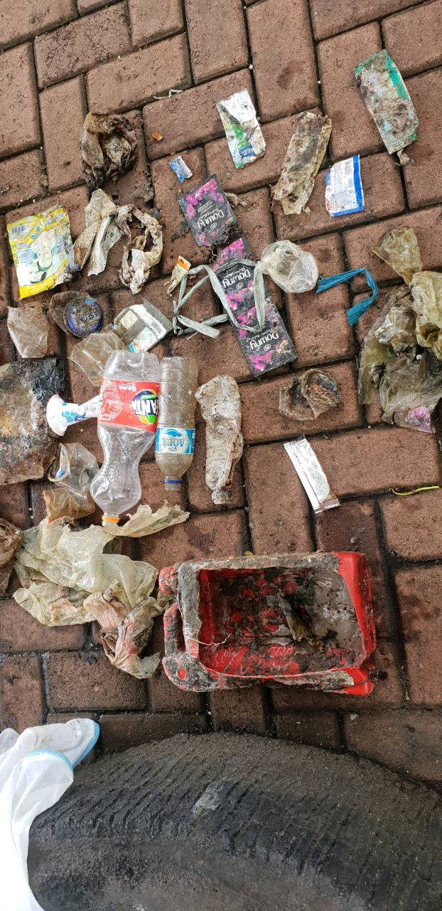
Will be doing a large river clean up in September as well covering this area and a lot more.
Trash Dumping
Part of a Metal Roof
Sunny & Hot
Mid-Missouri Sheriff's Dive Team/Scuba Adventure 2801
Harold Chris Heitman
5
2
65.00
120
21.00
1.00
estimated
3000.00
2
On
pounds
I have debris data to report
Calm (glassy to rippled) for waves 0 – 0.1 meter high ft2
feet
other
United States
State\Province
Missouri
City
Jefferson City
Map Help


Dive Location

If you know your survey site coordinates, enter them manually in decimal degrees using WGS84 Map Datum. Use the minus sign for latitudes south of the equator and longitudes west of the Prime Meridian to 180 degrees.

If you do not know your survey site coordinates, click the “Map Location” tab to use the map to zoom into your survey site and drop the pin on the map to fall within your survey dive site in the water (not on land or the beach). Ensure you zoom in as much as possible to ensure data accuracy.

Entangled Help


Use the vertical tabs below to record any entangled animals you found of each type.

Ecosystem Other
River Bottom

ADS352 - Meno Slope

19
5
1
0

-8.35026, 116.0511

0
0
0
coral
0
0
0
0
0
Windy
Gili Shark Conservation
Nico And Zara
0
0
0
1
0
0
0
0
1
0
0
0
0
0
0
0
0
0
0
12
3
0
0
0
0
0
4
1
0
0
0
0
0
0
0
0
3.00
40
25.00
10.00
1
estimated
0
0
0
0
70341.40
0
0
0
0
0
0
On
kilograms
0
I have debris data to report
0
0
0
Calm (glassy to rippled) for waves 0 – 0.1 meter high
7
0
0
0
0
0
0
m2
0
0
meters
coral reef
0
0
0
0
0
0
0
0
0
0
0
0
0
0
0
0
0
0
0
0
0
0
0
0
0
0
0
0
0
Indonesia
State\Province
West Nusa Tenggara
City
Gili Air
Map Help


Dive Location

If you know your survey site coordinates, enter them manually in decimal degrees using WGS84 Map Datum. Use the minus sign for latitudes south of the equator and longitudes west of the Prime Meridian to 180 degrees.

If you do not know your survey site coordinates, click the “Map Location” tab to use the map to zoom into your survey site and drop the pin on the map to fall within your survey dive site in the water (not on land or the beach). Ensure you zoom in as much as possible to ensure data accuracy.

Entangled Help


Use the vertical tabs below to record any entangled animals you found of each type.

Hummingbird Reef

1
5
coral
1
50

13.858224590896, -61.063437915938

It is a huge problem on this dive site; all the fishing line is affecting the corals. We found a lot of line wrapped in the coral. We have weighted all the fishing line and the total is 3 pounds.
A lot of fishing line in the area and no dive against debris in a few good years.
This was a class for Dive Against Debris with 6 students from Kids Sea Camp.
Designer Jeans Shorts
Good weather, a bit cloudy.
1
1
1
cork
electrical wire
anchor shaft
Scuba St lucia
Georgiana Merlusca
1
1
7
1
16.00
47
55.00
16.00
measured
18
650.00
1
1
fishing line
plastic fragments
fishing weights
1
On
pounds
I have debris data to report
2
Smooth (wavelets) for waves 0.1 - 0.5 meter high
1
1
3
ft2
feet
coral reef
2
1
1
1
Saint Lucia
City
Soufriere
Map Help


Dive Location

If you know your survey site coordinates, enter them manually in decimal degrees using WGS84 Map Datum. Use the minus sign for latitudes south of the equator and longitudes west of the Prime Meridian to 180 degrees.

If you do not know your survey site coordinates, click the “Map Location” tab to use the map to zoom into your survey site and drop the pin on the map to fall within your survey dive site in the water (not on land or the beach). Ensure you zoom in as much as possible to ensure data accuracy.

Entangled Help


Use the vertical tabs below to record any entangled animals you found of each type.

Ferry de bocas del toro

0
83
2

9.3353224924484, -82.239740408051

0
0
1
sand
1
3
3
7
3
Was a debris in collaboration with other dive shops from the island. BOCAS DIVING PIRATES ,LA BUGA DIVE CENTER , BOCAS DIVE CENTER , SUPER DIVERS BOCAS , PANAMA DIVE SCHOOL and collaboration of the local government.
Sunny days perfect conditions
0
0
0
0
0
0
0
0
0
0
0
0
0
0
0
0
0
0
0
0
Bocas diving pirates
Alexis chacon
0
14
0
86
0
0
3
0
0
0
2
1
1
1
1
1
0
0
0
12
0
0
9
0
0
91
0
3
0
0
0
0
1
0
500.00
180
8.00
4.00
8
estimated
0
0
80.65
0
7
0
0
0
0
On
kilograms
0
I have debris data to report
500
0
0
Calm (glassy to rippled) for waves 0 – 0.1 meter high
0
1
11
Pvc tubes , latas , bottles
Dead
Calamares
Sea Urchins, Crabs,star brits , Cleaners Fish
Released Unharmed
25
1
Bottlel
0
72
0
0
m2
0
1
meters
seagrass
72
0
0
0
0
0
0
1
0
3
0
0
0
10
0
48
0
0
0
2
1
81
1
0
0
0
0
0
Panama
State\Province
Bocas del toro
City
Isla colon
Map Help


Dive Location

If you know your survey site coordinates, enter them manually in decimal degrees using WGS84 Map Datum. Use the minus sign for latitudes south of the equator and longitudes west of the Prime Meridian to 180 degrees.

If you do not know your survey site coordinates, click the “Map Location” tab to use the map to zoom into your survey site and drop the pin on the map to fall within your survey dive site in the water (not on land or the beach). Ensure you zoom in as much as possible to ensure data accuracy.

Entangled Help


Use the vertical tabs below to record any entangled animals you found of each type.

Ladiko

1
0
0

36.320140329511, 28.207064845633

0
0
0
sand
1
0
0
4
0
Tourism
Baby towel
Sunny and hot
1
0
0
0
0
0
0
0
0
0
0
0
0
0
0
0
0
0
0
0
Plastic hairband
InDepth
Katie
0
0
0
0
0
0
0
0
0
1
0
0
0
0
0
0
0
2
0
2
0
0
0
0
0
0
0
1
0
0
0
0
0
0
5.00
61
10.50
1.00
0
estimated
0
0
18605.20
0
0
0
1
0
Fishing line and hooks
Plastic fragments
0
On
kilograms
0
I have debris data to report
1
0
0
Smooth (wavelets) for waves 0.1 - 0.5 meter high
0
0
0
0
2
0
0
m2
0
1
meters
rocky reef
0
0
0
0
0
4
0
4
0
0
0
0
2
0
0
1
0
0
0
1
0
15
0
0
0
0
0
0
Greece
State\Province
Rhodes
City
Afandou
Map Help


Dive Location

If you know your survey site coordinates, enter them manually in decimal degrees using WGS84 Map Datum. Use the minus sign for latitudes south of the equator and longitudes west of the Prime Meridian to 180 degrees.

If you do not know your survey site coordinates, click the “Map Location” tab to use the map to zoom into your survey site and drop the pin on the map to fall within your survey dive site in the water (not on land or the beach). Ensure you zoom in as much as possible to ensure data accuracy.

Entangled Help


Use the vertical tabs below to record any entangled animals you found of each type.

ADS434 - Anchor Bay

5

35.9597251, 14.3404018

sand
1
Good
No strong winds
Scuba Life Malta
Jacqui Hedley
1
1
2
8
1
2.00
65
16.70
5.00
measured
500.00
On
kilograms
I have debris data to report
Calm (glassy to rippled) for waves 0 – 0.1 meter high
1
m2
1
meters
seagrass
2
1
Malta
City
Mellieha
Map Help


Dive Location

If you know your survey site coordinates, enter them manually in decimal degrees using WGS84 Map Datum. Use the minus sign for latitudes south of the equator and longitudes west of the Prime Meridian to 180 degrees.

If you do not know your survey site coordinates, click the “Map Location” tab to use the map to zoom into your survey site and drop the pin on the map to fall within your survey dive site in the water (not on land or the beach). Ensure you zoom in as much as possible to ensure data accuracy.

Entangled Help


Use the vertical tabs below to record any entangled animals you found of each type.

ADS434 - Anchor Bay

3
7

35.9597251, 14.340404018

1
sand
2
2
Good, not very windy.
Calm seas
1
Fibre glass chunk from boat
Scuba Life Malta
Jacqui Hedley
2
2
1
3
1
1
30.00
60
7.40
1.50
measured
3
50.00
String/rope
On
kilograms
I have debris data to report
Smooth (wavelets) for waves 0.1 - 0.5 meter high
1
1
m2
9
meters
seagrass
1
1
1
1
1
1
3
1
1
Malta
City
Mellieha
Map Help


Dive Location

If you know your survey site coordinates, enter them manually in decimal degrees using WGS84 Map Datum. Use the minus sign for latitudes south of the equator and longitudes west of the Prime Meridian to 180 degrees.

If you do not know your survey site coordinates, click the “Map Location” tab to use the map to zoom into your survey site and drop the pin on the map to fall within your survey dive site in the water (not on land or the beach). Ensure you zoom in as much as possible to ensure data accuracy.

Entangled Help


Use the vertical tabs below to record any entangled animals you found of each type.

Jahir

0
61
0
0

1.4789617, 125.2360803

0
0
0
sand
0
1
0
0
0
No
Lightbulb
Drizzle
The Submersibles
Ying Kai
0
0
1
9
0
0
0
0
0
3
0
0
0
0
6
0
0
0
0
8
1
0
0
4
1
0
3
0
0
0
0
0
0
0
0
0
6.00
75
18.00
6.00
0
measured
0
0
0
0
492.46
0
0
0
0
0
Plastic fragments
Cups
Cloth bags
0
On
kilograms
0
I have debris data to report
0
0
0
Calm (glassy to rippled) for waves 0 – 0.1 meter high
2
0
0
7
0
1
0
m2
1
1
meters
other
1
0
0
0
0
0
0
0
0
0
0
0
1
0
0
0
0
2
0
1
0
0
0
0
1
0
0
0
0
Indonesia
State\Province
North Sulawesi
City
Lembeh
Map Help


Dive Location

If you know your survey site coordinates, enter them manually in decimal degrees using WGS84 Map Datum. Use the minus sign for latitudes south of the equator and longitudes west of the Prime Meridian to 180 degrees.

If you do not know your survey site coordinates, click the “Map Location” tab to use the map to zoom into your survey site and drop the pin on the map to fall within your survey dive site in the water (not on land or the beach). Ensure you zoom in as much as possible to ensure data accuracy.

Entangled Help


Use the vertical tabs below to record any entangled animals you found of each type.

Abu Hashish

0
0
0
0

27.042884, 33.91215

2
0
0
sand
0
1
1
2
0
Lots of dive boats
Aquarius Diving Centre
Greg Du Bois
0
0
0
0
10
0
0
0
0
0
0
0
0
0
0
0
0
8
12
2
1
2
0
0
0
0
2
0
0
0
0
0
0
0
0
0
0.50
20
12.00
8.00
0
estimated
0
0
0
0
20.00
0
0
0
0
0
Plastic
Cigarette butts
Fishing line
0
On
kilograms
0
I have debris data to report
0
0
0
Calm (glassy to rippled) for waves 0 – 0.1 meter high
0
0
0
0
0
0
0
m2
0
0
meters
coral reef
0
0
0
0
0
0
0
0
0
0
0
0
0
0
0
0
0
0
0
0
0
0
0
0
0
0
0
0
0
Egypt
Map Help


Dive Location

If you know your survey site coordinates, enter them manually in decimal degrees using WGS84 Map Datum. Use the minus sign for latitudes south of the equator and longitudes west of the Prime Meridian to 180 degrees.

If you do not know your survey site coordinates, click the “Map Location” tab to use the map to zoom into your survey site and drop the pin on the map to fall within your survey dive site in the water (not on land or the beach). Ensure you zoom in as much as possible to ensure data accuracy.

Entangled Help


Use the vertical tabs below to record any entangled animals you found of each type.

ADS238 - Chabahr Bay

coral

25.319357685559, 60.620549228548

Amir Ghazilou
1
3
3
2
3.00
60
5.00
3.00
measured
100.00
On
kilograms
I have debris data to report
1
Smooth (wavelets) for waves 0.1 - 0.5 meter high m2
meters
coral reef
3
Iran
Map Help


Dive Location

If you know your survey site coordinates, enter them manually in decimal degrees using WGS84 Map Datum. Use the minus sign for latitudes south of the equator and longitudes west of the Prime Meridian to 180 degrees.

If you do not know your survey site coordinates, click the “Map Location” tab to use the map to zoom into your survey site and drop the pin on the map to fall within your survey dive site in the water (not on land or the beach). Ensure you zoom in as much as possible to ensure data accuracy.

Entangled Help


Use the vertical tabs below to record any entangled animals you found of each type.

Subscribe to