Menu

ADS323 - Tung Ping Chau

8
25
4

22.545909, 114.431823

sand
9
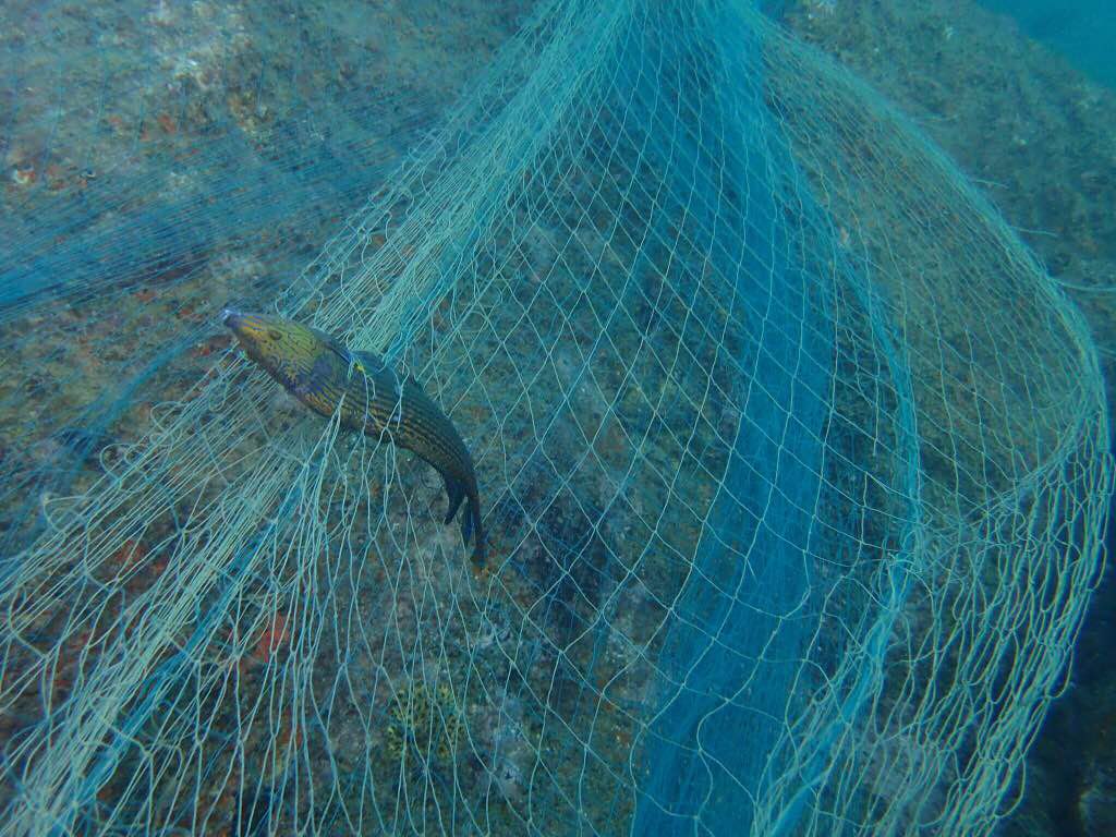
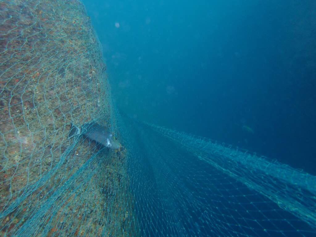
In this second dive our goal was to revisit the two area marked during our fist dive and remove the ghost nets and the ropes.
Abandoned fishing gears by local fishermen
CD/DVD holder
Rainy, windy periods alternating with sunny periods
1
1
Plastic CD/DVD holder
Medication packaging
Tursiopsdivers
Tursiopsdivers
4
5
5
10
1
1
21.50
37
4.10
1.40
14
measured
1
89.00
fishing net and fishing line
ropes
On
kilograms
I have debris data to report
Calm (glassy to rippled) for waves 0 – 0.1 meter high m2
meters
coral reef
2
2
Hong Kong S.A.R., China
City
Tung Ping Chau Island
Map Help


Dive Location

If you know your survey site coordinates, enter them manually in decimal degrees using WGS84 Map Datum. Use the minus sign for latitudes south of the equator and longitudes west of the Prime Meridian to 180 degrees.

If you do not know your survey site coordinates, click the “Map Location” tab to use the map to zoom into your survey site and drop the pin on the map to fall within your survey dive site in the water (not on land or the beach). Ensure you zoom in as much as possible to ensure data accuracy.

Entangled Help


Use the vertical tabs below to record any entangled animals you found of each type.

ADS323 - Tung Ping Chau

50
64
3
7

22.545909, 114.431823

sand
2
27
1
1
2
In our first dive we have our team had five buddy pairs, the survey area was divided using five transect lines and the survey was conducted systematically. During the dive a big ghost net and an area with lots of interconnecting old ropes and nets were discovered by two different buddy teams. Both area were marked and during our second dive our whole team revisited and cleans these areas.
Brought by the current form mainland China
Computer pieces, shoe sole, lunheon meat
Rainy, windy periods alternating with sunny periods
1
1
1
1
Dubber cap
Can of luncheon meat (unopened)
Medication packaging
Phone case
Tursiopsdivers
Tursiopsdivers
11
4
19
3
1
10
3
4
6
7
1
21.03
57
6.70
1.20
3
measured
4946.95
2
plastic wraps
other plastic items
2
On
kilograms
I have debris data to report
4
Calm (glassy to rippled) for waves 0 – 0.1 meter high
1
1
1
1
m2
meters
coral reef
1
1
1
2
30
1
5
1
Hong Kong S.A.R., China
City
Tung Ping Chau Island
Map Help


Dive Location

If you know your survey site coordinates, enter them manually in decimal degrees using WGS84 Map Datum. Use the minus sign for latitudes south of the equator and longitudes west of the Prime Meridian to 180 degrees.

If you do not know your survey site coordinates, click the “Map Location” tab to use the map to zoom into your survey site and drop the pin on the map to fall within your survey dive site in the water (not on land or the beach). Ensure you zoom in as much as possible to ensure data accuracy.

Entangled Help


Use the vertical tabs below to record any entangled animals you found of each type.

ADS282 - Banana Bay

3
5
0

7.498956, 98.325533

0
0
0
sand
0
0
0
18
0
Fishing and tourism
Rags
Storm
0
0
0
0
0
0
0
0
0
0
0
0
0
0
0
0
0
0
0
0
All4Diving
Nicolas bergere
0
0
0
0
0
0
0
0
1
0
0
0
0
0
0
0
0
0
0
2
0
0
0
0
0
0
0
0
0
0
0
0
0
0
3.00
150
26.00
1.00
4
estimated
0
0
4000.00
0
0
0
1
0
Fishing line
Bottle
Food wrapper
0
On
kilograms
0
I have debris data to report
2
0
0
Smooth (wavelets) for waves 0.1 - 0.5 meter high
0
0
0
0
0
0
0
m2
0
1
meters
coral reef
1
0
0
0
0
2
0
0
0
0
0
0
0
0
0
0
1
0
0
0
0
0
0
0
0
0
0
0
Thailand
State\Province
Phuket
City
Patong
Map Help


Dive Location

If you know your survey site coordinates, enter them manually in decimal degrees using WGS84 Map Datum. Use the minus sign for latitudes south of the equator and longitudes west of the Prime Meridian to 180 degrees.

If you do not know your survey site coordinates, click the “Map Location” tab to use the map to zoom into your survey site and drop the pin on the map to fall within your survey dive site in the water (not on land or the beach). Ensure you zoom in as much as possible to ensure data accuracy.

Entangled Help


Use the vertical tabs below to record any entangled animals you found of each type.

Director's Bay

0
5
0
0

12.066021, -68.860192

0
0
0
coral
0
0
0
350
0
5xl shorts
Sunny
The Dive Bus
Collin
0
0
0
0
0
0
0
0
0
0
0
0
0
0
0
0
0
0
0
16
0
0
0
0
0
0
0
0
0
0
0
0
0
0
0
0
10.00
60
25.00
5.00
0
measured
0
0
0
7
500.00
0
0
0
0
0
Fishing line
0
On
kilograms
0
I have debris data to report
9
0
0
Smooth (wavelets) for waves 0.1 - 0.5 meter high
0
0
0
0
11
0
0
m2
0
0
meters
coral reef
10
0
0
0
0
0
0
0
0
0
0
0
0
0
0
0
0
0
0
0
0
0
21
0
0
0
0
0
0
Netherlands Antilles
State\Province
Curacao
City
Willemstad
Map Help


Dive Location

If you know your survey site coordinates, enter them manually in decimal degrees using WGS84 Map Datum. Use the minus sign for latitudes south of the equator and longitudes west of the Prime Meridian to 180 degrees.

If you do not know your survey site coordinates, click the “Map Location” tab to use the map to zoom into your survey site and drop the pin on the map to fall within your survey dive site in the water (not on land or the beach). Ensure you zoom in as much as possible to ensure data accuracy.

Entangled Help


Use the vertical tabs below to record any entangled animals you found of each type.

San Niklaw Bay

20
4
5
1
seagrass
1
2
20

36.016473234459, 14.329652577921

Thank you to all the participants of our Womens Dive Day Clean Up.
both sticked on the spickes of the sea cucumber
plastic sea star
calm
1
1
1
Metal chain
Plastic starfish
diamand bracelett
Comino Diveshack
Bine
2
2
1
2
5
25
10
1
5
8
2
50.00
60
6.00
1.00
15
estimated
5332.33
1
3
ropes
fishing line
glas fragments
On
kilograms
I have debris data to report
4
1
Calm (glassy to rippled) for waves 0 – 0.1 meter high
3
cigarette filter and paper
1
Released Unharmed
Sea Cucumber
4
2
1
m2
meters
seagrass
15
4
3
1
2
5
11
Malta
State\Province
Malta
City
Comino
Map Help


Dive Location

If you know your survey site coordinates, enter them manually in decimal degrees using WGS84 Map Datum. Use the minus sign for latitudes south of the equator and longitudes west of the Prime Meridian to 180 degrees.

If you do not know your survey site coordinates, click the “Map Location” tab to use the map to zoom into your survey site and drop the pin on the map to fall within your survey dive site in the water (not on land or the beach). Ensure you zoom in as much as possible to ensure data accuracy.

Entangled Help


Use the vertical tabs below to record any entangled animals you found of each type.

Lighthouse

0
13
0
1

10.120376, 99.842921

0
0
0
sand
0
0
0
30
0
No
Towel
Wavy, some rain
Davy Jones Locker
Monique Richards
0
0
0
0
0
0
0
0
0
0
1
0
0
2
0
0
0
1
0
4
0
0
0
0
0
0
7
0
0
0
0
0
0
0
0
0
3.00
51
13.00
3.00
0
estimated
0
0
0
0
3507.10
0
0
0
1
0
Fishing line
Plastic bittles
Fragments
0
On
kilograms
0
I have debris data to report
1
0
0
Smooth (wavelets) for waves 0.1 - 0.5 meter high
0
0
0
0
0
0
0
m2
0
1
meters
coral reef
0
0
0
0
0
1
0
0
0
0
0
0
0
2
0
1
0
0
0
0
0
0
2
0
0
0
0
0
0
Thailand
State\Province
Surat Thani
City
Koh Tao
Map Help


Dive Location

If you know your survey site coordinates, enter them manually in decimal degrees using WGS84 Map Datum. Use the minus sign for latitudes south of the equator and longitudes west of the Prime Meridian to 180 degrees.

If you do not know your survey site coordinates, click the “Map Location” tab to use the map to zoom into your survey site and drop the pin on the map to fall within your survey dive site in the water (not on land or the beach). Ensure you zoom in as much as possible to ensure data accuracy.

Entangled Help


Use the vertical tabs below to record any entangled animals you found of each type.

Loutraki Dive Club 14/7/2018 Skaloma

4
5
1
sand
3
5

38.017691291128, 22.900568927327

Loutraki Dive Club 14/7/2018 Skaloma
At this event we were 9 divers and 3 land support
very good
1
1
1
1
1
1
3
1
1
line reel
Boat Rub Rail
plastic sack
tenis
the top piece of a boat
chain
sheet metal from roof
boat tent
navigational lamp
Loutraki Dive Club
Nikos_Ba
1
2
6
1
9
2
14
4
1
226.00
41
18.00
3.00
25
measured
4
3313.00
10
On
kilograms
I have debris data to report
3
Calm (glassy to rippled) for waves 0 – 0.1 meter high
1
1
m2
1
buoys
1 small octopus
Released Unharmed
meters
seagrass
1
1
2
30
2
Greece
State\Province
Corinthia
City
Loutraki
Map Help


Dive Location

If you know your survey site coordinates, enter them manually in decimal degrees using WGS84 Map Datum. Use the minus sign for latitudes south of the equator and longitudes west of the Prime Meridian to 180 degrees.

If you do not know your survey site coordinates, click the “Map Location” tab to use the map to zoom into your survey site and drop the pin on the map to fall within your survey dive site in the water (not on land or the beach). Ensure you zoom in as much as possible to ensure data accuracy.

Entangled Help


Use the vertical tabs below to record any entangled animals you found of each type.

Butterfly Rock

0
0
0

8.629425, 81.234216

0
0
0
rock
0
0
0
2
0
Fishing line entangled in rocks
On shore winds
0
0
0
0
0
0
0
0
0
0
0
0
0
0
0
0
0
0
0
0
Scuba Safaris
Dave
0
0
0
0
0
0
0
0
0
0
0
0
0
0
0
0
0
0
0
2
0
0
0
0
0
0
0
0
0
0
0
0
0
0
1.00
53
11.00
8.00
0
estimated
0
2
132.08
0
0
0
0
0
0
On
kilograms
0
I have debris data to report
0
0
0
Smooth (wavelets) for waves 0.1 - 0.5 meter high
0
0
0
0
0
0
0
m2
0
0
meters
rocky reef
0
0
0
0
0
0
0
0
0
0
0
0
0
0
0
0
0
0
0
0
0
0
0
0
0
0
0
0
Sri Lanka
City
Trincomalee
Map Help


Dive Location

If you know your survey site coordinates, enter them manually in decimal degrees using WGS84 Map Datum. Use the minus sign for latitudes south of the equator and longitudes west of the Prime Meridian to 180 degrees.

If you do not know your survey site coordinates, click the “Map Location” tab to use the map to zoom into your survey site and drop the pin on the map to fall within your survey dive site in the water (not on land or the beach). Ensure you zoom in as much as possible to ensure data accuracy.

Entangled Help


Use the vertical tabs below to record any entangled animals you found of each type.

Rowe’s Rocks

0
0
1

8.639454, 81.240026

0
0
0
rock
0
2
0
4
0
Local fishermen
Approx 50 m of net. Ran out of air. Approx 50 m left behind.
Massive net
On shore winds
0
0
0
0
0
0
0
0
0
0
0
0
0
0
0
0
0
0
0
0
Scuba Safaris
Dave
0
0
0
0
0
0
0
0
0
0
0
0
0
0
0
0
0
0
0
2
0
0
0
0
0
0
0
0
0
0
0
0
0
0
3.00
43
18.00
5.00
0
estimated
0
0
297.59
0
0
0
0
0
Massive net
0
On
kilograms
0
I have debris data to report
0
0
0
Smooth (wavelets) for waves 0.1 - 0.5 meter high
0
0
0
Trapped in tangled fishing net
2
Released Unharmed
Wrasse
0
0
0
0
m2
0
0
meters
rocky reef
0
0
0
0
0
0
0
0
0
0
0
0
0
0
0
0
0
0
0
0
0
0
0
0
0
0
0
0
Sri Lanka
City
Trincomalee
Map Help


Dive Location

If you know your survey site coordinates, enter them manually in decimal degrees using WGS84 Map Datum. Use the minus sign for latitudes south of the equator and longitudes west of the Prime Meridian to 180 degrees.

If you do not know your survey site coordinates, click the “Map Location” tab to use the map to zoom into your survey site and drop the pin on the map to fall within your survey dive site in the water (not on land or the beach). Ensure you zoom in as much as possible to ensure data accuracy.

Entangled Help


Use the vertical tabs below to record any entangled animals you found of each type.

ADS137 - Vouliagmeni Lake Loutraki

57
1
2
sand
15
4

38.031833311242, 22.873491379236

ADS137 - Vouliagmeni Lake Loutraki 7/7/2018
At this event we were 6 divers and 2 land support
very good
1
1
5
3
1
3
1
1
1
2
1
1
1
1
1
1
2
1
sun glasses
cartridge cover
line reel
shoe heels
paddle
shoe sole
clips belt
wipes packaging
plastic sack
plastic mesh
hand net
diving mask glass
aluminum cup
aluminum profile
a portion of milk
plastic rail
BMX GRIPS
disposable razor blade
Loutraki Dive Club
Nikos_Ba
1
9
38
1
6
3
56
1
49.00
51
19.50
2.00
5
measured
3
1986.00
On
kilograms
I have debris data to report
8
Calm (glassy to rippled) for waves 0 – 0.1 meter high
5
cans , plastic bottles
Injured
various small fish
CRABs + crayfish
Released Unharmed
35
25
cans , plastic bottles
6
m2
meters
seagrass
3
1
1
4
166
2
3
2
36
Greece
State\Province
Corinthia
City
Loutraki
Map Help


Dive Location

If you know your survey site coordinates, enter them manually in decimal degrees using WGS84 Map Datum. Use the minus sign for latitudes south of the equator and longitudes west of the Prime Meridian to 180 degrees.

If you do not know your survey site coordinates, click the “Map Location” tab to use the map to zoom into your survey site and drop the pin on the map to fall within your survey dive site in the water (not on land or the beach). Ensure you zoom in as much as possible to ensure data accuracy.

Entangled Help


Use the vertical tabs below to record any entangled animals you found of each type.

Subscribe to