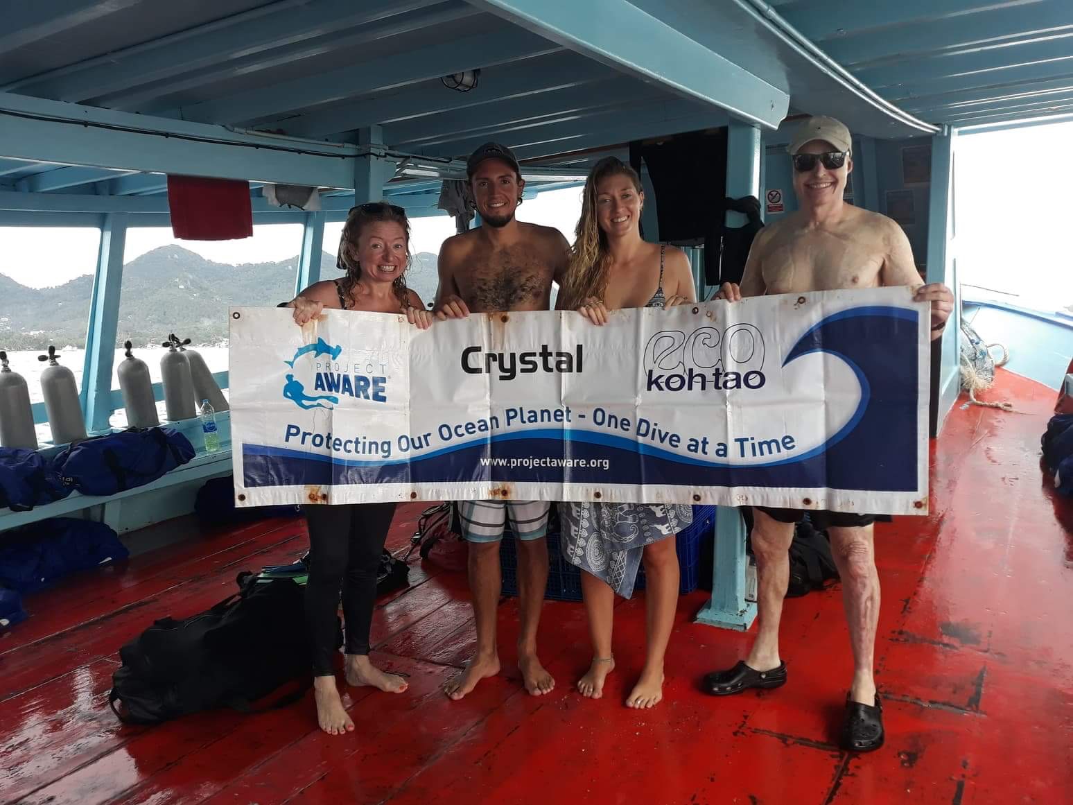
Menu

Mango Bay, Koh Tao

4
sand
4

10.123005468693, 99.836282730103

Rain, Overcast, Low Pressure atmosphere, light - moderate winds all week.
Crystal Dive, Koh Tao
Jamie Hull
1
1
1
2
4
1.00
60
15.00
6.00
6
estimated
100.00
1
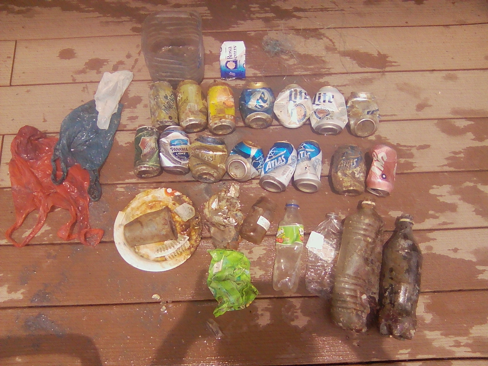
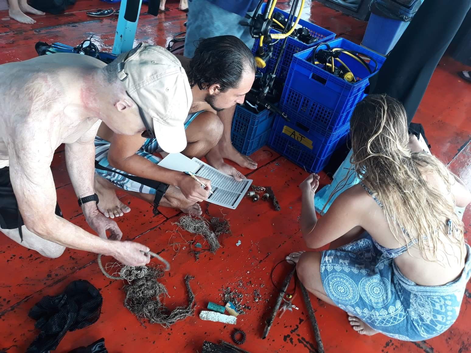
Fishing line - Entanglement Risk
Metal fragments - Small sharp fragments pose risk
Plastic Fragments - Risk of consumption by marine life - Food chain!
On
kilograms
I have debris data to report
Calm (glassy to rippled) for waves 0 – 0.1 meter high
2
m2
4
meters
coral reef
4
1
2
Thailand
State\Province
Surat Thani
City
Koh Tao
Map Help


Dive Location

If you know your survey site coordinates, enter them manually in decimal degrees using WGS84 Map Datum. Use the minus sign for latitudes south of the equator and longitudes west of the Prime Meridian to 180 degrees.

If you do not know your survey site coordinates, click the “Map Location” tab to use the map to zoom into your survey site and drop the pin on the map to fall within your survey dive site in the water (not on land or the beach). Ensure you zoom in as much as possible to ensure data accuracy.

Entangled Help


Use the vertical tabs below to record any entangled animals you found of each type.

ADS424 - New Club Reef

10
35
3
0

24.845218, 51.507888

0
0
0
sand
1
0
0
0
0
No
Sunny
Qdivers
Jaco
0
0
0
5
0
0
0
0
0
0
0
0
0
0
0
0
0
3
2
2
0
0
0
0
0
0
11
0
0
0
0
0
0
0
0
0
2.00
21
15.00
5.00
0
measured
0
0
0
0
866.00
0
0
0
0
0
Plastic beverage bottles
Plastic food wrappers
Beverage cans
0
On
kilograms
0
I have debris data to report
1
0
0
Calm (glassy to rippled) for waves 0 – 0.1 meter high
2
0
0
0
0
0
0
m2
0
0
meters
other
0
0
0
0
0
1
0
1
0
0
0
0
0
2
0
0
0
7
0
0
0
0
0
0
0
0
0
0
0
Qatar
State\Province
Doha
City
Mesaieed
Map Help


Dive Location

If you know your survey site coordinates, enter them manually in decimal degrees using WGS84 Map Datum. Use the minus sign for latitudes south of the equator and longitudes west of the Prime Meridian to 180 degrees.

If you do not know your survey site coordinates, click the “Map Location” tab to use the map to zoom into your survey site and drop the pin on the map to fall within your survey dive site in the water (not on land or the beach). Ensure you zoom in as much as possible to ensure data accuracy.

Entangled Help


Use the vertical tabs below to record any entangled animals you found of each type.

Mango Bay, Koh Tao

10
sand
4

10.124213500909, 99.836246454782

Rainy, Overcast, low pressure atmosphere, light - moderate winds
Eco Koh Tao - Crystal Dive
Jennifer Dowling
2
1
4
1
2.00
61
12.00
4.00
estimated
100.00
Plastic Fragments
Rope and String
Fishing Line
2
On
kilograms
I have debris data to report
Calm (glassy to rippled) for waves 0 – 0.1 meter high
2
1
m2
6
meters
coral reef
1
3
1
1
1
Thailand
State\Province
Surat Thani
City
Koh Tao
Map Help


Dive Location

If you know your survey site coordinates, enter them manually in decimal degrees using WGS84 Map Datum. Use the minus sign for latitudes south of the equator and longitudes west of the Prime Meridian to 180 degrees.

If you do not know your survey site coordinates, click the “Map Location” tab to use the map to zoom into your survey site and drop the pin on the map to fall within your survey dive site in the water (not on land or the beach). Ensure you zoom in as much as possible to ensure data accuracy.

Entangled Help


Use the vertical tabs below to record any entangled animals you found of each type.

Mango Bay, Koh Tao

4
1
sand

10.122666639383, 99.835395315529

Rainy, overcast, low pressure atmosphere, light - moderate winds
Eco Koh Tao - Crystal Dive
Jennifer Dowling
1
1
1
4
1.30
61
16.00
4.00
estimated
100.00
1
Rope and String
Plastic Fragments
Metal Fragments
On
kilograms
I have debris data to report
Calm (glassy to rippled) for waves 0 – 0.1 meter high
1
m2
6
meters
coral reef
2
1
Thailand
State\Province
Surat Thani
City
Koh Tao
Map Help


Dive Location

If you know your survey site coordinates, enter them manually in decimal degrees using WGS84 Map Datum. Use the minus sign for latitudes south of the equator and longitudes west of the Prime Meridian to 180 degrees.

If you do not know your survey site coordinates, click the “Map Location” tab to use the map to zoom into your survey site and drop the pin on the map to fall within your survey dive site in the water (not on land or the beach). Ensure you zoom in as much as possible to ensure data accuracy.

Entangled Help


Use the vertical tabs below to record any entangled animals you found of each type.

ADS333 - Corsaire

2

-4.616933, 55.40745

coral
For the second time in a row we found almost no trash at this site which is amazing to see. Considering its location, right next to a diving and fishing port, there was almost no trash and the reef appeared extremely healthy!
No.
Hairband
Sunny, calm seas. Occasional downpour
GVI Cap Ternay
Andy Ezeta
12
0.10
35
14.80
5.00
estimated
3750.00
On
kilograms
I have debris data to report
Calm (glassy to rippled) for waves 0 – 0.1 meter high
1
m2
1
meters
coral reef
Seychelles
State\Province
Mahe
City
Victoria
Map Help


Dive Location

If you know your survey site coordinates, enter them manually in decimal degrees using WGS84 Map Datum. Use the minus sign for latitudes south of the equator and longitudes west of the Prime Meridian to 180 degrees.

If you do not know your survey site coordinates, click the “Map Location” tab to use the map to zoom into your survey site and drop the pin on the map to fall within your survey dive site in the water (not on land or the beach). Ensure you zoom in as much as possible to ensure data accuracy.

Entangled Help


Use the vertical tabs below to record any entangled animals you found of each type.

Japanese Garden

0
0
0
0

10.116813, 99.815203

0
0
0
sand
0
0
0
0
0
Very clean no other debris
Recent dropping of large concrete hollow cubes for fish abrogation?
Not sure where this came from. Tied to whole Palm fronds and covered live corals.
30m of thick nylon strap
Calm, sunny
Davy Jones Locker
Monique
0
0
0
0
0
0
0
0
0
0
0
0
0
6
0
0
0
0
0
2
0
0
0
0
0
0
0
0
0
0
0
0
0
0
0
0
4.50
46
15.00
12.00
0
estimated
0
0
0
0
486.40
0
0
0
0
0
Nylon strap
Na
Na
0
On
kilograms
0
I have debris data to report
0
0
0
Calm (glassy to rippled) for waves 0 – 0.1 meter high
0
0
0
0
0
0
0
m2
0
0
meters
coral reef
0
0
0
0
0
0
0
0
0
0
0
0
0
0
0
0
0
0
0
0
0
0
0
0
0
0
0
0
0
Thailand
State\Province
Surat Thani
City
Koh Tao
Map Help


Dive Location

If you know your survey site coordinates, enter them manually in decimal degrees using WGS84 Map Datum. Use the minus sign for latitudes south of the equator and longitudes west of the Prime Meridian to 180 degrees.

If you do not know your survey site coordinates, click the “Map Location” tab to use the map to zoom into your survey site and drop the pin on the map to fall within your survey dive site in the water (not on land or the beach). Ensure you zoom in as much as possible to ensure data accuracy.

Entangled Help


Use the vertical tabs below to record any entangled animals you found of each type.

ADS01 - Lighthouse Bay

7
20
1
4

10.120406195041, 99.844177812338

4
coral
1
10
2
Rare weather patterns with typhoons in nearby countries, along with fisherman staying in the bay and snorkelling tours.
none
raining
2
1
Motorbike straps for motorbike helmets
Full Blue Paint Container
Assava Dive Resort
Natalie Hunt
2
31
2
27
25
5
1
18
12.00
90
13.00
3.00
measured
2
200.00
1
Plastic bottles
1
On
kilograms
I have debris data to report
4
Slight for waves 0.5 -1.25 meter high
2
in fishing net
1
Released Unharmed
Shell - Mollusc
2
m2
1
fishing line
mollusc shell
Released Unharmed
meters
coral reef
1
3
5
28
3
Thailand
State\Province
Surat Thani
City
Koh Tao
Map Help


Dive Location

If you know your survey site coordinates, enter them manually in decimal degrees using WGS84 Map Datum. Use the minus sign for latitudes south of the equator and longitudes west of the Prime Meridian to 180 degrees.

If you do not know your survey site coordinates, click the “Map Location” tab to use the map to zoom into your survey site and drop the pin on the map to fall within your survey dive site in the water (not on land or the beach). Ensure you zoom in as much as possible to ensure data accuracy.

Entangled Help


Use the vertical tabs below to record any entangled animals you found of each type.

Ka Osting

23

11.345756, 124.118481

rock
7
10
CLoudy, Rainy and medium waves. Two days before Typhoon Ompong hit North of Philippines.
Evolution Dive Center
Anne Rutten
1
3
2
5.00
70
7.00
4.00
estimated
5020.98
On
kilograms
I have debris data to report
Slight for waves 0.5 -1.25 meter high
3
m2
meters
rocky reef
2
3
2
Philippines
State\Province
Cebu
City
Malapascua
Map Help


Dive Location

If you know your survey site coordinates, enter them manually in decimal degrees using WGS84 Map Datum. Use the minus sign for latitudes south of the equator and longitudes west of the Prime Meridian to 180 degrees.

If you do not know your survey site coordinates, click the “Map Location” tab to use the map to zoom into your survey site and drop the pin on the map to fall within your survey dive site in the water (not on land or the beach). Ensure you zoom in as much as possible to ensure data accuracy.

Entangled Help


Use the vertical tabs below to record any entangled animals you found of each type.

ADS352 - Meno Slope

2
4
0
0

-8.35026, 116.0511

0
0
0
coral
0
0
0
0
0
Windy
2
Shampoo Wrapper
Gili Shark Conservation
Zara And Katon
0
0
0
0
0
0
0
0
0
0
0
0
0
0
0
0
0
0
0
9
0
0
0
0
0
0
1
0
0
0
0
0
0
0
0
0
2.50
37
23.00
10.00
0
estimated
0
0
0
0
6297.40
0
0
0
0
0
0
On
kilograms
0
I have debris data to report
0
0
0
Calm (glassy to rippled) for waves 0 – 0.1 meter high
1
0
0
0
0
0
0
m2
0
0
meters
coral reef
0
0
0
0
0
0
0
0
1
0
0
0
0
0
0
0
0
0
0
0
0
0
0
0
0
0
0
0
0
Indonesia
State\Province
West Nusa Tenggara
City
Gili Air
Map Help


Dive Location

If you know your survey site coordinates, enter them manually in decimal degrees using WGS84 Map Datum. Use the minus sign for latitudes south of the equator and longitudes west of the Prime Meridian to 180 degrees.

If you do not know your survey site coordinates, click the “Map Location” tab to use the map to zoom into your survey site and drop the pin on the map to fall within your survey dive site in the water (not on land or the beach). Ensure you zoom in as much as possible to ensure data accuracy.

Entangled Help


Use the vertical tabs below to record any entangled animals you found of each type.

Bocas dive center peer

sand
3
1

9.335083879517, -82.241330548738

Thanks for the good job ?
Calm
Bocas Dive Center
Liza Roux
3
3
1
4
1
1
1.00
30
14.50
2.50
estimated
100.00
Beer cans
Beer bottles
Fishing lines
On
kilograms
I have debris data to report
Calm (glassy to rippled) for waves 0 – 0.1 meter high m2
meters
other
15
1
Panama
State\Province
Bocas del toro
City
Bocas
Map Help


Dive Location

If you know your survey site coordinates, enter them manually in decimal degrees using WGS84 Map Datum. Use the minus sign for latitudes south of the equator and longitudes west of the Prime Meridian to 180 degrees.

If you do not know your survey site coordinates, click the “Map Location” tab to use the map to zoom into your survey site and drop the pin on the map to fall within your survey dive site in the water (not on land or the beach). Ensure you zoom in as much as possible to ensure data accuracy.

Entangled Help


Use the vertical tabs below to record any entangled animals you found of each type.

Ecosystem Other
Sandy bottom
Subscribe to