Menu

McAbee Beach

14
4

36.603592, -121.887789

rock
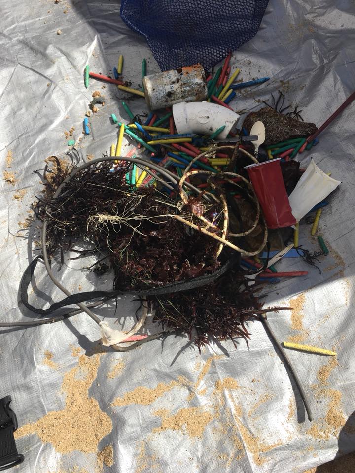
A restaurant, located on the pier, seems to be responsible for supplying all the 300+ crayons we found on the bottom of the sea floor.
We were featured on the News (see video link below):
https://www.ksbw.com/article/monterey-divers-find-hundreds-of-crayons-littering-ocean-floor/23288143?fbclid=IwAR3lLEVXSdRY_czivyZBKAhFKREKJKL7RgQBWvYbDoaqVrzO0k9Mq51nh_I
crayons
Sunny and calm
Melissa Boyd
1
4
1
20
335
3
138.31
51
40.00
5.00
measured
11
23218.00
1
10
crayons
2
On
pounds
I have debris data to report
Calm (glassy to rippled) for waves 0 – 0.1 meter high
1
1
ft2
1
feet
kelp
9
4
2
1
1
1
16
1
United States
State\Province
California
Map Help


Dive Location

If you know your survey site coordinates, enter them manually in decimal degrees using WGS84 Map Datum. Use the minus sign for latitudes south of the equator and longitudes west of the Prime Meridian to 180 degrees.

If you do not know your survey site coordinates, click the “Map Location” tab to use the map to zoom into your survey site and drop the pin on the map to fall within your survey dive site in the water (not on land or the beach). Ensure you zoom in as much as possible to ensure data accuracy.

Entangled Help


Use the vertical tabs below to record any entangled animals you found of each type.

ADS488 - Koh Rang

10
20
5
10

11.777807578053, 102.38840048533

3
3
coral
13
25
2
5
20
A lot of Rubber Engine Belts
Big Storm (Name: Pabuk) January 4th and 5th
BB Divers
BB Divers Koh Mak
15
5
20
26
2
7
16
1
1
30
8
25
25
30
25
26
5
5
5
40.00
35
9.00
5.00
30
estimated
3
1
5
600.00
15
plastics
net
On
kilograms
I have debris data to report
10
Calm (glassy to rippled) for waves 0 – 0.1 meter high
20
12
1
5
m2
25
6
1
Plastic bag
Octopus
Released Unharmed
meters
coral reef
1
2
1
3
5
1
3
4
4
1
1
1
Thailand
City
Koh Mak
Map Help


Dive Location

If you know your survey site coordinates, enter them manually in decimal degrees using WGS84 Map Datum. Use the minus sign for latitudes south of the equator and longitudes west of the Prime Meridian to 180 degrees.

If you do not know your survey site coordinates, click the “Map Location” tab to use the map to zoom into your survey site and drop the pin on the map to fall within your survey dive site in the water (not on land or the beach). Ensure you zoom in as much as possible to ensure data accuracy.

Entangled Help


Use the vertical tabs below to record any entangled animals you found of each type.

ADS482 - Long Beach

0
1
0
0

7.617043, 99.028423

0
0
0
sand
0
1
0
1
0
Headtorch
Small storm
Go Pro In Paradise & Lanta Diver
Richard Reardon
0
0
0
0
0
0
0
0
0
0
0
0
0
0
0
0
0
0
0
4
0
0
0
0
0
1
0
0
1
1
0
0
0
0
0
0
2.00
25
5.00
3.00
0
estimated
0
0
0
1
30.00
0
0
0
0
0
Plastic
0
On
kilograms
0
I have debris data to report
0
0
0
Calm (glassy to rippled) for waves 0 – 0.1 meter high
0
0
0
Fishing net
Crab
Released Unharmed
1
0
0
0
0
m2
0
0
meters
coral reef
0
0
0
0
0
0
0
0
0
0
1
0
0
0
0
0
0
0
0
0
0
0
0
0
0
0
0
0
0
Thailand
State\Province
Koh Lanta
City
Phra Ae
Map Help


Dive Location

If you know your survey site coordinates, enter them manually in decimal degrees using WGS84 Map Datum. Use the minus sign for latitudes south of the equator and longitudes west of the Prime Meridian to 180 degrees.

If you do not know your survey site coordinates, click the “Map Location” tab to use the map to zoom into your survey site and drop the pin on the map to fall within your survey dive site in the water (not on land or the beach). Ensure you zoom in as much as possible to ensure data accuracy.

Entangled Help


Use the vertical tabs below to record any entangled animals you found of each type.

ADS370 - Blue Bay The Wall & The Garden

37

12.134386, -68.985019

coral
97
etalNYE added the fireworks to our house reef!
Local construction increase the rubber/metal items and local fishermen leave lots of fishing line in our oceans.
Spark plug
sunny
1
1
1
1
1
AA Battery
Spark Plug
Earing
Sink Plug
Mask
Blue Bay Dive
PADI Master Instructor Ivana 356300
1
1
1
18
21
15
18.00
55
28.70
1.50
measured
2
2000.00
2
3
fishing line
plastic fragments
rubber
7
On
kilograms
I have debris data to report
12
Calm (glassy to rippled) for waves 0 – 0.1 meter high
1
2
0
11
m2
meters
coral reef
2
2
11
13
Netherlands Antilles
City
Curacao
Map Help


Dive Location

If you know your survey site coordinates, enter them manually in decimal degrees using WGS84 Map Datum. Use the minus sign for latitudes south of the equator and longitudes west of the Prime Meridian to 180 degrees.

If you do not know your survey site coordinates, click the “Map Location” tab to use the map to zoom into your survey site and drop the pin on the map to fall within your survey dive site in the water (not on land or the beach). Ensure you zoom in as much as possible to ensure data accuracy.

Entangled Help


Use the vertical tabs below to record any entangled animals you found of each type.

Shaw's Cove

0
0
0
0

33.545243, -117.798597

0
0
0
sand
0
0
0
0
0
No
Resistor
Heavy rain 4 days
Jade Scuba Adventures
Jake Fitzgerald
0
0
0
0
0
0
0
0
0
0
0
0
0
0
0
0
0
0
0
2
0
0
0
0
0
0
0
0
0
0
0
0
0
0
0
0
0.10
61
40.00
15.00
0
estimated
0
0
0
0
595.14
0
0
0
0
0
Resistor
0
On
pounds
0
I have debris data to report
0
0
0
Smooth (wavelets) for waves 0.1 - 0.5 meter high
0
0
0
0
0
0
0
m2
0
0
feet
rocky reef
0
0
0
0
0
0
0
0
0
0
0
0
0
0
0
0
0
0
0
0
0
0
0
0
1
0
0
0
0
United States
State\Province
California
City
Laguna Beach
Map Help


Dive Location

If you know your survey site coordinates, enter them manually in decimal degrees using WGS84 Map Datum. Use the minus sign for latitudes south of the equator and longitudes west of the Prime Meridian to 180 degrees.

If you do not know your survey site coordinates, click the “Map Location” tab to use the map to zoom into your survey site and drop the pin on the map to fall within your survey dive site in the water (not on land or the beach). Ensure you zoom in as much as possible to ensure data accuracy.

Entangled Help


Use the vertical tabs below to record any entangled animals you found of each type.

Horseshoe Reef Jan 2019 /FKNMS

25.08362, -80.17641

coral
On January 13 2019 we surveyed Horseshoe reef. We conducted two 30 minute surveys at the reef.We found 2 bottoms of lobster traps and loose trap material along with rope and fishing line. We will be returning to this site as we still need to survey the other side.
Lobster Harvest
Hurricane Irma
Boat trim
Wind 20-25 knots
Island Ventures
Michael Creese
8
75.00
60
25.00
6.00
estimated
200.00
Lobster traps
Rope
Lobster line
On
pounds
I have debris data to report
20
Calm (glassy to rippled) for waves 0 – 0.1 meter high m2
10
feet
coral reef
4
1
United States
State\Province
Florida
City
Key Largo
Map Help


Dive Location

If you know your survey site coordinates, enter them manually in decimal degrees using WGS84 Map Datum. Use the minus sign for latitudes south of the equator and longitudes west of the Prime Meridian to 180 degrees.

If you do not know your survey site coordinates, click the “Map Location” tab to use the map to zoom into your survey site and drop the pin on the map to fall within your survey dive site in the water (not on land or the beach). Ensure you zoom in as much as possible to ensure data accuracy.

Entangled Help


Use the vertical tabs below to record any entangled animals you found of each type.

Rainbow Reef

0
0
0

25.63894600117, -80.127727463664

0
0
0
coral
0
0
0
0
0
Choppy
0
1
0
0
0
0
0
0
0
0
0
0
0
0
0
0
0
0
0
0
Old ankle
Old Anchor
Squalo Divers
Alejandro Otero
0
0
0
0
0
0
0
0
0
0
0
0
0
0
0
0
0
0
0
2
0
0
0
0
0
0
0
0
0
0
0
0
0
0
10.00
40
24.00
18.00
0
estimated
0
0
100.00
0
0
0
0
0
Fishing lines
Cans
Bottles
0
On
pounds
0
I have debris data to report
0
0
0
Moderate to rough for waves greater than 1.25 meters
0
0
0
Injured
Ray
1
0
0
0
0
ft2
0
0
feet
coral reef
Fishing Line and Hook
0
0
0
0
0
0
0
0
0
0
0
0
0
0
0
0
0
0
0
0
0
0
0
0
0
0
0
0
United States
State\Province
Florida
City
Miami Beach
Map Help


Dive Location

If you know your survey site coordinates, enter them manually in decimal degrees using WGS84 Map Datum. Use the minus sign for latitudes south of the equator and longitudes west of the Prime Meridian to 180 degrees.

If you do not know your survey site coordinates, click the “Map Location” tab to use the map to zoom into your survey site and drop the pin on the map to fall within your survey dive site in the water (not on land or the beach). Ensure you zoom in as much as possible to ensure data accuracy.

Entangled Help


Use the vertical tabs below to record any entangled animals you found of each type.

Piscina Natural da Pajuçara - Maceió

12
2

-9.6734064240181, -35.709776898996

sand
2

-9.6809330171638, -35.712294703849

rain
Let's Dive
Fernanda Paiva
3
0
2
1
16
1
3
40.00
90
5.00
0.50
estimated
10000.00
3
On
kilograms
I have debris data to report
8
Calm (glassy to rippled) for waves 0 – 0.1 meter high
5
1
1
m2
8
meters
rocky reef
4
1
3
12
4
1
2
6
2
4
1
Brazil
State\Province
Alagoas
City
Maceió
Map Help


Dive Location

If you know your survey site coordinates, enter them manually in decimal degrees using WGS84 Map Datum. Use the minus sign for latitudes south of the equator and longitudes west of the Prime Meridian to 180 degrees.

If you do not know your survey site coordinates, click the “Map Location” tab to use the map to zoom into your survey site and drop the pin on the map to fall within your survey dive site in the water (not on land or the beach). Ensure you zoom in as much as possible to ensure data accuracy.

Entangled Help


Use the vertical tabs below to record any entangled animals you found of each type.

ADS422 - Koh Bida Nok

1

7.65417, 98.776609

coral

7.655, 98.7655556

Dive site was very clean at the area we dived. Possible deeper more debris can be found, but this was outside of our dive plan.
n/a
Sunny, calm, light breeze
Wanna come for a holiday?
3
marine paint flakes
Blue Planet Divers
Camille Lemmens
2
0.10
59
20.00
3.00
estimated
1.00
On
kilograms
I have debris data to report
Smooth (wavelets) for waves 0.1 - 0.5 meter high m2
1
meters
coral reef
Thailand
State\Province
Krabi
City
Ban Saladan, Koh Lanta
Map Help


Dive Location

If you know your survey site coordinates, enter them manually in decimal degrees using WGS84 Map Datum. Use the minus sign for latitudes south of the equator and longitudes west of the Prime Meridian to 180 degrees.

If you do not know your survey site coordinates, click the “Map Location” tab to use the map to zoom into your survey site and drop the pin on the map to fall within your survey dive site in the water (not on land or the beach). Ensure you zoom in as much as possible to ensure data accuracy.

Entangled Help


Use the vertical tabs below to record any entangled animals you found of each type.

ADS492 - Sunset

-17.635143716485, 177.06391847211

coral
Overcast, 10-20knots of wing
Deep Blue
Trev Neal
3
0.00
100
12.00
3.00
estimated
1000.00
On
kilograms
Our Survey Site was free of debris
Smooth (wavelets) for waves 0.1 - 0.5 meter high m2
meters
coral reef
Fiji
State\Province
Western
City
Matamanoa Island
Map Help


Dive Location

If you know your survey site coordinates, enter them manually in decimal degrees using WGS84 Map Datum. Use the minus sign for latitudes south of the equator and longitudes west of the Prime Meridian to 180 degrees.

If you do not know your survey site coordinates, click the “Map Location” tab to use the map to zoom into your survey site and drop the pin on the map to fall within your survey dive site in the water (not on land or the beach). Ensure you zoom in as much as possible to ensure data accuracy.

Entangled Help


Use the vertical tabs below to record any entangled animals you found of each type.

Subscribe to