Menu

Diamond Reef

18.46, -64.53

coral

18.464541837712, -64.526759551114

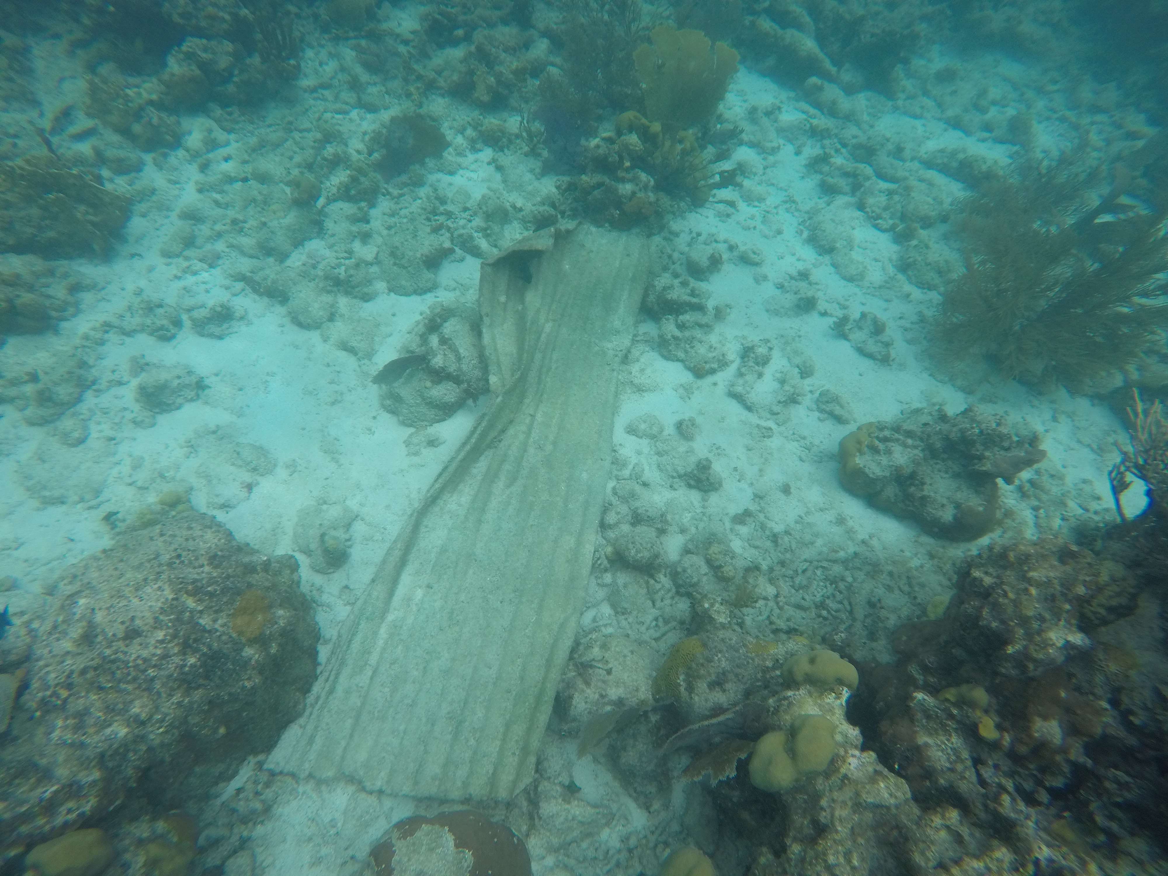
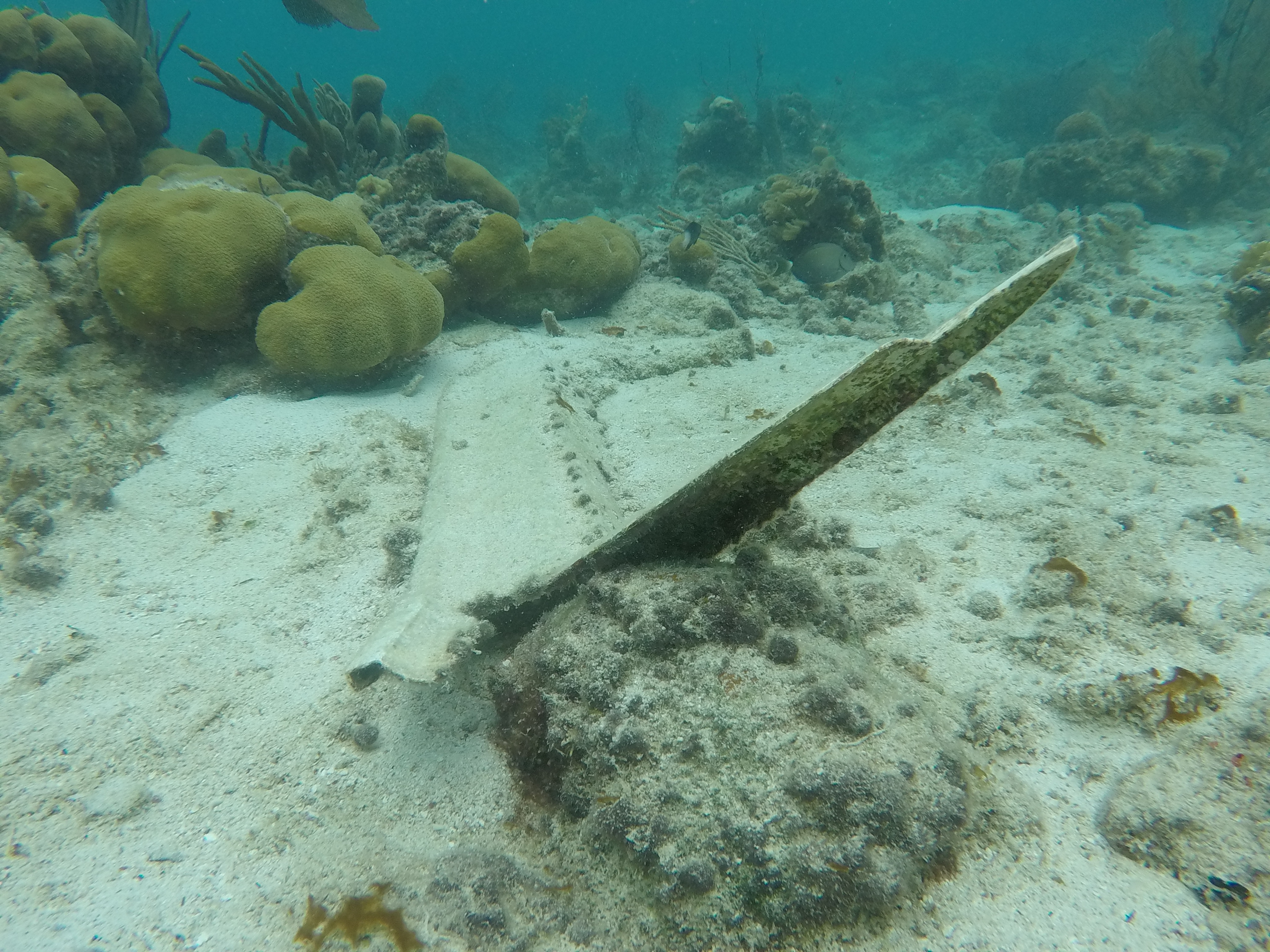
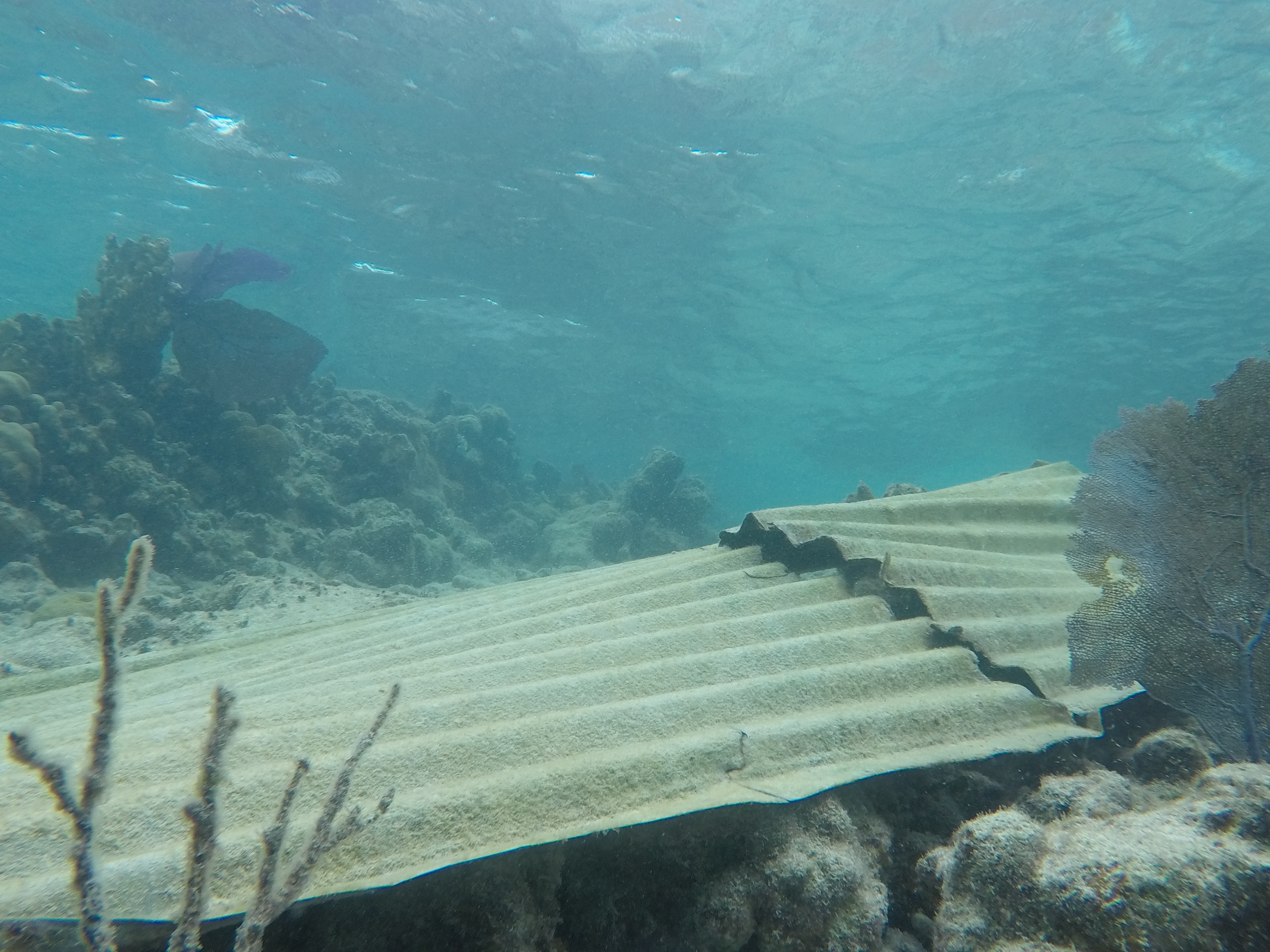
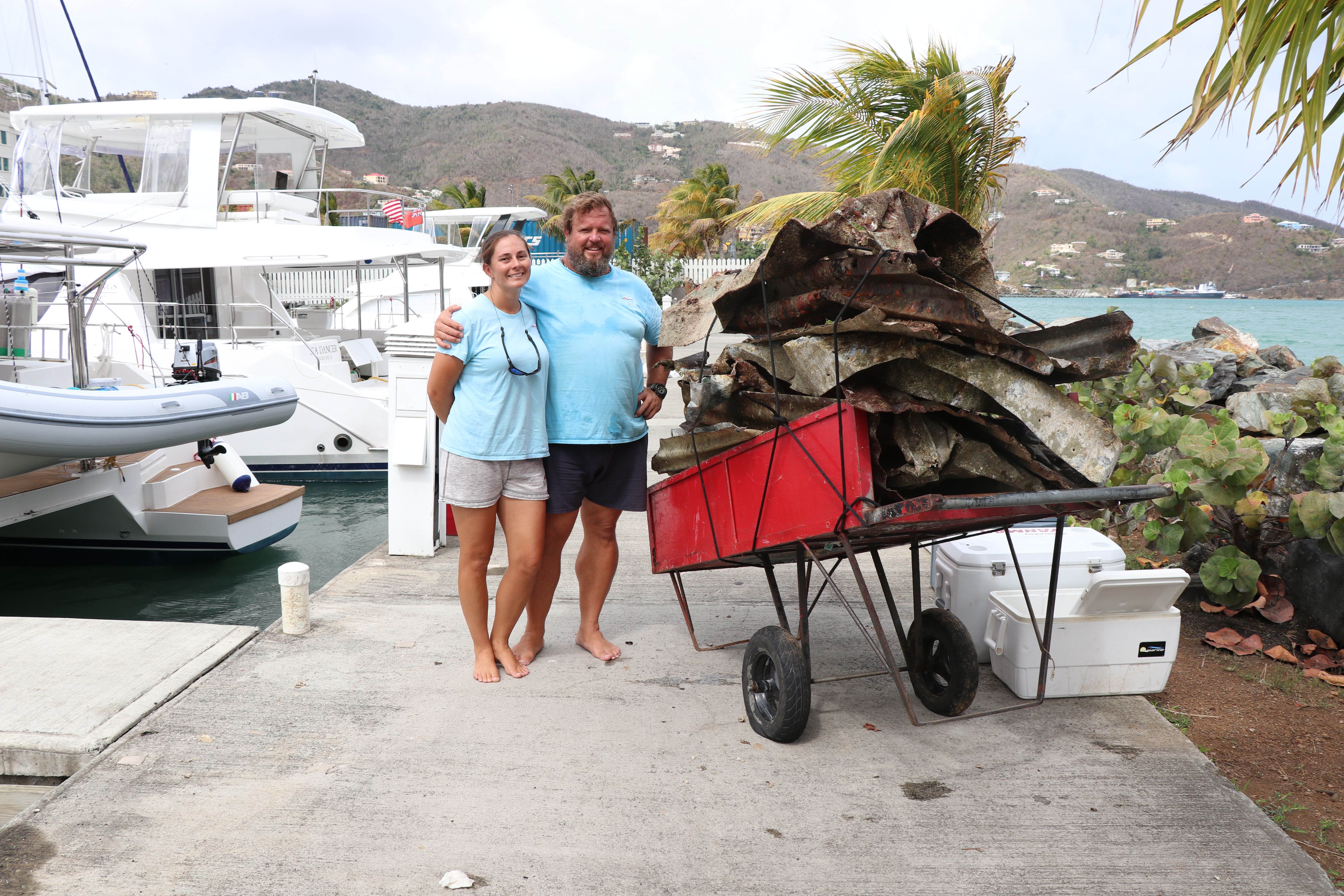
The coral and fish life are looking very healthy, despite the debris.
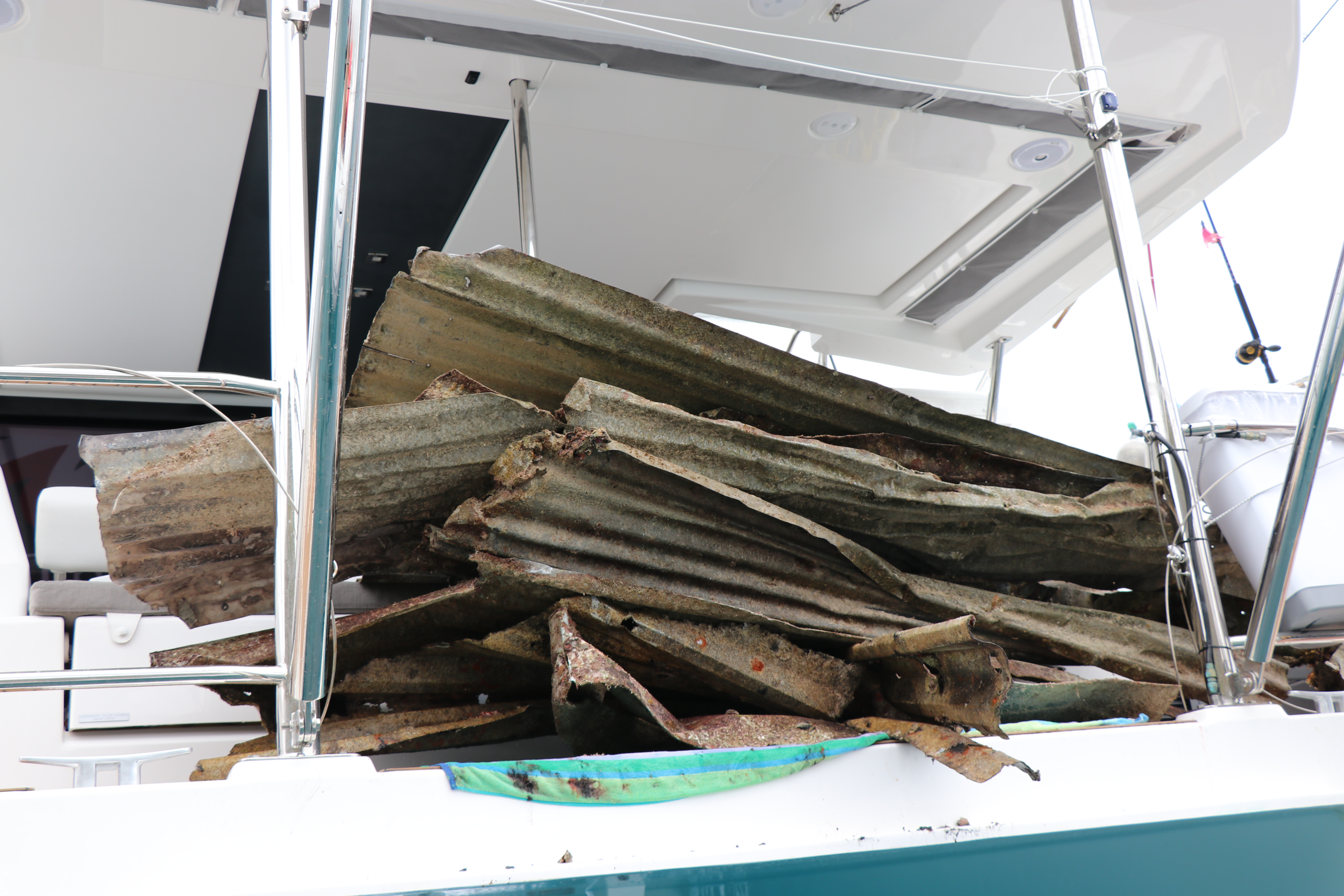
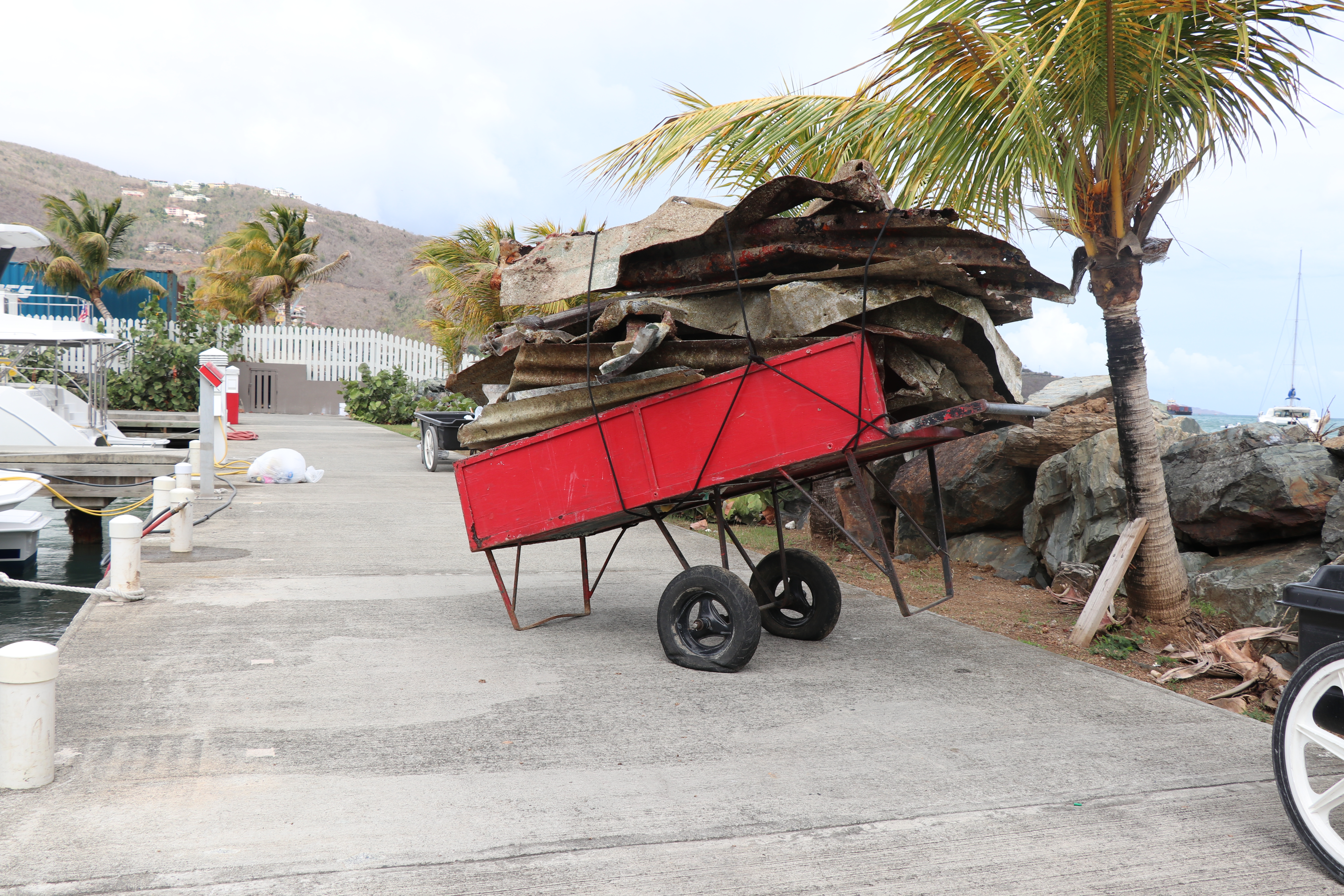
Hurricane Irma deposited all the sheet metal we found.
We only managed to do half the reef in the time we had available but we will be doing the other half soon. There is a lot more work to be done to clean up the whole of the BVI area, we are excited to do as much as we can.
Stormy for 2 days prior to dive.
Robin Willows
2
120.00
120
22.00
8.00
estimated
3000.00
Sheet metal
Cables
Wooden dock pieces
On
kilograms
I have debris data to report
Smooth (wavelets) for waves 0.1 - 0.5 meter high m2
feet
coral reef
19
British Virgin Islands
Map Help


Dive Location

If you know your survey site coordinates, enter them manually in decimal degrees using WGS84 Map Datum. Use the minus sign for latitudes south of the equator and longitudes west of the Prime Meridian to 180 degrees.

If you do not know your survey site coordinates, click the “Map Location” tab to use the map to zoom into your survey site and drop the pin on the map to fall within your survey dive site in the water (not on land or the beach). Ensure you zoom in as much as possible to ensure data accuracy.

Entangled Help


Use the vertical tabs below to record any entangled animals you found of each type.

Vlachorema Beach

3
11
0
0

39.167464, 23.337646

0
2
0
sand
0
5
0
0
0
Clothes pin
Sunny
BiodiversityGR
Chris
0
0
0
0
0
0
0
0
0
0
0
0
1
0
0
0
0
1
0
1
0
0
0
0
0
0
1
0
0
0
0
0
0
0
0
0
0.17
75
4.00
1.00
3
measured
0
0
0
0
7246.89
0
0
0
0
0
Plastic pieces and bags
0
On
kilograms
0
I have debris data to report
0
0
0
Calm (glassy to rippled) for waves 0 – 0.1 meter high
0
0
0
0
6
0
0
m2
0
0
meters
rocky reef
0
0
0
0
0
1
0
0
0
0
0
0
0
1
0
0
0
0
0
0
0
0
0
0
0
0
0
0
0
Greece
State\Province
Magnesia
City
Argalasti
Map Help


Dive Location

If you know your survey site coordinates, enter them manually in decimal degrees using WGS84 Map Datum. Use the minus sign for latitudes south of the equator and longitudes west of the Prime Meridian to 180 degrees.

If you do not know your survey site coordinates, click the “Map Location” tab to use the map to zoom into your survey site and drop the pin on the map to fall within your survey dive site in the water (not on land or the beach). Ensure you zoom in as much as possible to ensure data accuracy.

Entangled Help


Use the vertical tabs below to record any entangled animals you found of each type.

ADS518 - Batu Bolong

-8.536846, 119.614061

coral
Some wind from the south east
Azul Unlimited
Aitor
4
0.00
47
22.00
5.00
measured
80.35
On
kilograms
Our Survey Site was free of debris
Smooth (wavelets) for waves 0.1 - 0.5 meter high m2
meters
coral reef
Indonesia
State\Province
Manggarai Barat
City
Labuan Bajo
Map Help


Dive Location

If you know your survey site coordinates, enter them manually in decimal degrees using WGS84 Map Datum. Use the minus sign for latitudes south of the equator and longitudes west of the Prime Meridian to 180 degrees.

If you do not know your survey site coordinates, click the “Map Location” tab to use the map to zoom into your survey site and drop the pin on the map to fall within your survey dive site in the water (not on land or the beach). Ensure you zoom in as much as possible to ensure data accuracy.

Entangled Help


Use the vertical tabs below to record any entangled animals you found of each type.

ADS496 - Kiwi Reef

coral
15

29.406248139885, 34.975734314156

Sinai Divers
Paul
4
29
12
9.00
54
25.00
5.00
estimated
50.00
On
kilograms
I have debris data to report
Calm (glassy to rippled) for waves 0 – 0.1 meter high m2
meters
coral reef
Jordan
City
aqaba
Map Help


Dive Location

If you know your survey site coordinates, enter them manually in decimal degrees using WGS84 Map Datum. Use the minus sign for latitudes south of the equator and longitudes west of the Prime Meridian to 180 degrees.

If you do not know your survey site coordinates, click the “Map Location” tab to use the map to zoom into your survey site and drop the pin on the map to fall within your survey dive site in the water (not on land or the beach). Ensure you zoom in as much as possible to ensure data accuracy.

Entangled Help


Use the vertical tabs below to record any entangled animals you found of each type.

ADS496 - Kiwi Reef

coral
1
15

29.406263987944, 34.975813474377

Boat, but left it there
Sinai Divers
Paul Rose
6
1
4
12
6
15
9.00
54
25.00
5.00
estimated
50.00
4
On
kilograms
I have debris data to report
Smooth (wavelets) for waves 0.1 - 0.5 meter high m2
meters
coral reef
Jordan
City
Aqaba
Map Help


Dive Location

If you know your survey site coordinates, enter them manually in decimal degrees using WGS84 Map Datum. Use the minus sign for latitudes south of the equator and longitudes west of the Prime Meridian to 180 degrees.

If you do not know your survey site coordinates, click the “Map Location” tab to use the map to zoom into your survey site and drop the pin on the map to fall within your survey dive site in the water (not on land or the beach). Ensure you zoom in as much as possible to ensure data accuracy.

Entangled Help


Use the vertical tabs below to record any entangled animals you found of each type.

ADS192 - Laplight

25
2
0
0

11.344716, 124.106955

0
0
0
sand
0
0
0
0
0
Part of IDC training
No
Helium balloon
Sunny
4
Teabags
Thresher Shark Divers
Grace Garrett
0
0
0
0
3
0
0
0
0
0
0
0
0
3
0
0
0
0
10
2
0
0
0
0
3
0
0
0
0
0
0
1
0
0
0
0
5.75
54
22.00
5.00
29
measured
0
0
0
0
631.86
0
0
0
1
0
Rice bags
Plastic line
Food wrappers
0
On
kilograms
0
I have debris data to report
3
0
0
Smooth (wavelets) for waves 0.1 - 0.5 meter high
1
0
0
0
0
1
0
m2
2
0
meters
coral reef
2
0
0
0
0
0
0
0
0
0
0
0
0
0
0
0
1
0
0
0
0
0
0
0
0
0
0
0
0
Philippines
State\Province
Cebu
City
Malapascua
Map Help


Dive Location

If you know your survey site coordinates, enter them manually in decimal degrees using WGS84 Map Datum. Use the minus sign for latitudes south of the equator and longitudes west of the Prime Meridian to 180 degrees.

If you do not know your survey site coordinates, click the “Map Location” tab to use the map to zoom into your survey site and drop the pin on the map to fall within your survey dive site in the water (not on land or the beach). Ensure you zoom in as much as possible to ensure data accuracy.

Entangled Help


Use the vertical tabs below to record any entangled animals you found of each type.

ADS352 - Meno Slope

4
2
0
0

-8.35026, 116.0511

0
0
0
coral
0
0
0
0
0
Sunny
1
1
Mat
Hairband
Gili Shark Conservation
Katon
0
0
0
0
0
0
0
0
0
0
0
0
0
0
0
0
0
0
0
5
0
0
0
0
0
0
3
0
0
0
0
0
0
0
0
0
0.50
30
24.00
15.00
0
estimated
0
0
0
0
6840.00
0
0
0
0
0
0
On
kilograms
0
I have debris data to report
0
0
0
Calm (glassy to rippled) for waves 0 – 0.1 meter high
6
0
0
0
0
0
0
m2
1
0
meters
coral reef
0
0
0
0
0
0
0
0
0
0
0
0
0
0
0
0
0
0
0
0
0
0
0
0
0
0
0
0
0
Indonesia
State\Province
West Nusa Tenggara
City
Gili Air
Map Help


Dive Location

If you know your survey site coordinates, enter them manually in decimal degrees using WGS84 Map Datum. Use the minus sign for latitudes south of the equator and longitudes west of the Prime Meridian to 180 degrees.

If you do not know your survey site coordinates, click the “Map Location” tab to use the map to zoom into your survey site and drop the pin on the map to fall within your survey dive site in the water (not on land or the beach). Ensure you zoom in as much as possible to ensure data accuracy.

Entangled Help


Use the vertical tabs below to record any entangled animals you found of each type.

ADS535 - Bigth Reef

0
0
0
0

21.786222, -72.212212085724

0
0
0
coral
0
0
0
0
0
Beaches Turks and Caicos
Mark Healey
0
0
0
0
0
0
0
0
0
0
0
0
0
0
0
0
0
0
0
6
0
0
0
0
0
0
0
0
0
0
0
0
0
0
0
0
4.00
30
100.00
60.00
0
estimated
0
0
0
0
100.00
0
0
0
0
0
Beverage bottle
0
On
pounds
0
I have debris data to report
6
0
0
Calm (glassy to rippled) for waves 0 – 0.1 meter high
0
0
0
0
0
0
0
ft2
0
0
feet
coral reef
0
0
0
0
0
0
0
0
0
0
0
0
0
0
0
0
0
0
0
0
0
0
0
0
0
0
0
0
0
Turks and Caicos Islands
Map Help


Dive Location

If you know your survey site coordinates, enter them manually in decimal degrees using WGS84 Map Datum. Use the minus sign for latitudes south of the equator and longitudes west of the Prime Meridian to 180 degrees.

If you do not know your survey site coordinates, click the “Map Location” tab to use the map to zoom into your survey site and drop the pin on the map to fall within your survey dive site in the water (not on land or the beach). Ensure you zoom in as much as possible to ensure data accuracy.

Entangled Help


Use the vertical tabs below to record any entangled animals you found of each type.

ADS533 - Island Reef

0
0
0
0

18.332077, -78.34515

0
0
0
coral
0
2
0
0
0
Sandals Negril
Elfred Greenfield
0
0
0
4
0
0
0
0
0
0
0
0
0
0
0
0
0
0
0
6
0
0
0
0
0
0
2
0
0
0
0
0
0
0
0
0
2.00
45
30.00
20.00
1
estimated
0
0
0
0
6295.90
0
0
0
0
0
Plastic cups
Rope
0
On
pounds
0
I have debris data to report
0
0
0
Calm (glassy to rippled) for waves 0 – 0.1 meter high
0
0
0
0
0
0
0
ft2
0
0
feet
coral reef
0
0
0
0
0
0
0
0
0
0
0
0
0
0
0
0
0
0
0
0
0
0
0
0
0
0
0
0
0
Jamaica
State\Province
Westmoreland
City
Negril
Map Help


Dive Location

If you know your survey site coordinates, enter them manually in decimal degrees using WGS84 Map Datum. Use the minus sign for latitudes south of the equator and longitudes west of the Prime Meridian to 180 degrees.

If you do not know your survey site coordinates, click the “Map Location” tab to use the map to zoom into your survey site and drop the pin on the map to fall within your survey dive site in the water (not on land or the beach). Ensure you zoom in as much as possible to ensure data accuracy.

Entangled Help


Use the vertical tabs below to record any entangled animals you found of each type.

Address Harbour

22
30
0
0

25.463693, 56.363909

0
0
0
rock
0
12
0
0
0
Proximity to construction sites
1
1
1
2
Gaffer Tape
Metal cutting disk
Metal mesh
Measuring Tape
Divers Down UAE
2
9
1
13
0
0
0
0
0
0
0
0
17
3
0
0
0
26
0
5
0
0
0
3
21
0
54
1
0
6
0
0
0
0
0
0
45.00
48
6.00
1.00
6
measured
0
0
0
0
500.00
0
0
0
0
0
Plastic bags
Plastic sheetings
Plastic bottles
0
On
kilograms
0
I have debris data to report
2
1
1
Slight for waves 0.5 -1.25 meter high
3
0
0
0
0
0
0
m2
0
0
meters
rocky reef
10
0
6
0
0
0
0
0
0
0
0
0
1
3
0
1
1
10
0
0
0
0
1
2
0
0
0
0
0
United Arab Emirates
City
Fujairah
Map Help


Dive Location

If you know your survey site coordinates, enter them manually in decimal degrees using WGS84 Map Datum. Use the minus sign for latitudes south of the equator and longitudes west of the Prime Meridian to 180 degrees.

If you do not know your survey site coordinates, click the “Map Location” tab to use the map to zoom into your survey site and drop the pin on the map to fall within your survey dive site in the water (not on land or the beach). Ensure you zoom in as much as possible to ensure data accuracy.

Entangled Help


Use the vertical tabs below to record any entangled animals you found of each type.

Subscribe to