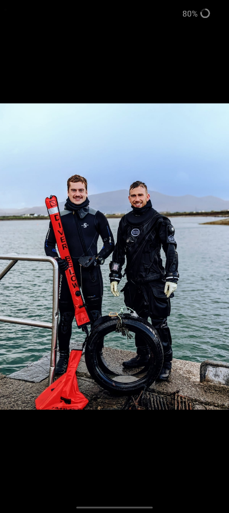
Menu

Scraggane Bay

0
0
0
0

52.310434, -10.033643

0
0
0
sand
0
0
0
0
0
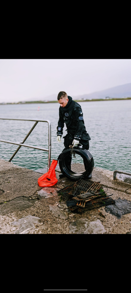
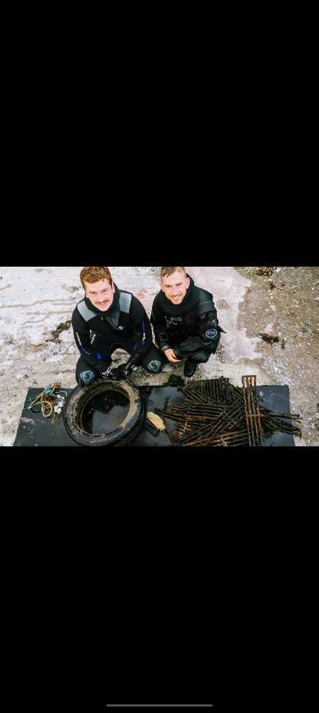
We used strong recycled rope and lift bags to retrieve the metal & tyres as they were to heavy to lift by hand, once the items were lifted & our pockets were full of smaller marine debris we surfaced to swim the lift bags to our point of exit
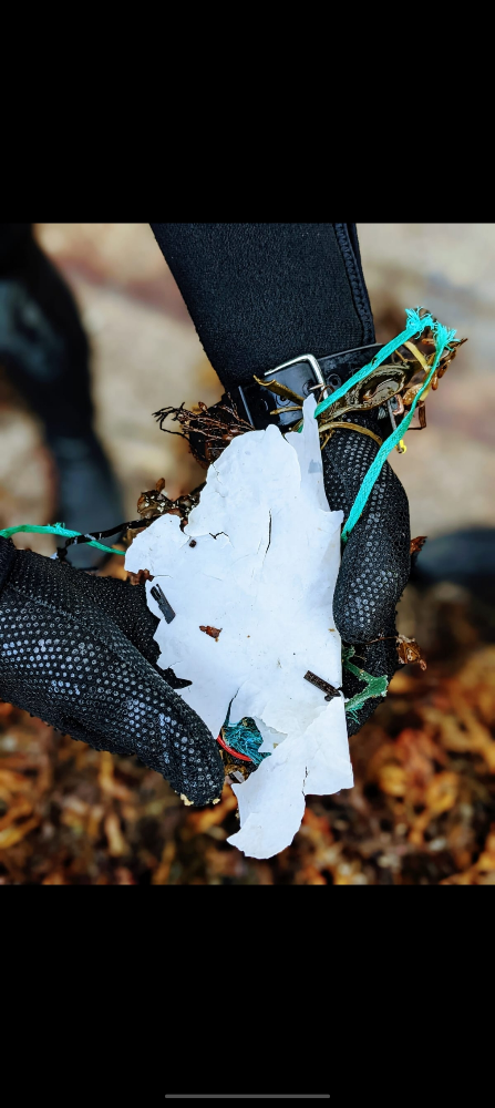
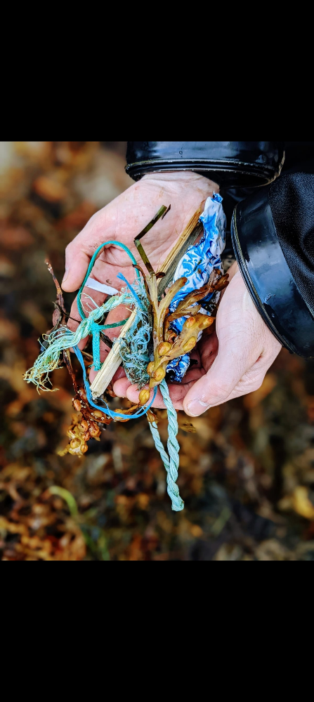
Commercial fishermen throwing over discarded crab pots beyond repair & washed up plastic
This is our local training site so implementing clean ups regularly will ensure a healthy environment for all trainees
Was sat In Underneath a pile of metal grates, removed and released onto the sand bed
Moderate rain fall, south westerly winds with a slow rising swell
1
Brush head
Waterworld #2731
Danny Oreilly
0
0
0
0
0
0
0
0
0
0
0
0
0
0
0
0
0
0
0
2
0
0
0
0
0
0
0
0
0
0
0
0
0
0
0
0
38.20
35
4.00
2.00
3
measured
0
0
0
0
235.59
0
1
1
3
0
Discarded metal crab pots
Plastic
Rubber
0
On
kilograms
0
I have debris data to report
0
0
0
Smooth (wavelets) for waves 0.1 - 0.5 meter high
0
0
0
Metal
Crab
Released Unharmed
1
0
0
0
0
m2
2
0
meters
rocky reef
16
0
0
0
0
0
0
0
0
0
0
0
0
0
0
0
0
0
0
0
0
0
0
0
0
0
0
0
0
Ireland
State\Province
Munster
City
Castlegregory
Map Help


Dive Location

If you know your survey site coordinates, enter them manually in decimal degrees using WGS84 Map Datum. Use the minus sign for latitudes south of the equator and longitudes west of the Prime Meridian to 180 degrees.

If you do not know your survey site coordinates, click the “Map Location” tab to use the map to zoom into your survey site and drop the pin on the map to fall within your survey dive site in the water (not on land or the beach). Ensure you zoom in as much as possible to ensure data accuracy.

Entangled Help


Use the vertical tabs below to record any entangled animals you found of each type.

Punta Brava #936868

0
0
0
0

41.766464550892, 3.0028253832211

0
0
1
rock
0
0
0
0
0
No
Plastic
Good
ScubaMobula
Guillermo
0
1
0
0
0
0
0
0
0
0
0
0
0
1
0
0
0
0
0
1
0
0
0
0
0
0
0
0
0
0
0
0
0
0
0
0
1.00
42
14.00
4.00
0
estimated
0
0
6662.49
0
0
0
0
0
Plastic
Cans
Rubber
0
On
kilograms
0
I have debris data to report
0
0
0
Slight for waves 0.5 -1.25 meter high
0
0
0
0
0
0
0
m2
0
0
meters
seagrass
0
0
0
0
0
0
0
0
0
0
0
0
0
0
0
0
0
1
0
0
0
0
0
0
0
0
0
0
0
Spain
State\Province
Girona
City
Sant Feliu de Guixols
Map Help


Dive Location

If you know your survey site coordinates, enter them manually in decimal degrees using WGS84 Map Datum. Use the minus sign for latitudes south of the equator and longitudes west of the Prime Meridian to 180 degrees.

If you do not know your survey site coordinates, click the “Map Location” tab to use the map to zoom into your survey site and drop the pin on the map to fall within your survey dive site in the water (not on land or the beach). Ensure you zoom in as much as possible to ensure data accuracy.

Entangled Help


Use the vertical tabs below to record any entangled animals you found of each type.

La Balsa Park #444200

10
3
1
3

-26.686266, 153.134338

96
0
0
silt
1
0
1
250
0
Popular recreational fishing and picnic area on the river
No
Photos available
Toy car
Sunshine Coast Clean Up Divers
Elliot Peters
0
5
0
3
0
0
0
0
0
0
2
0
0
1
0
0
0
4
0
14
0
0
1
0
0
0
2
0
0
1
0
0
0
0
0
0
71.20
70
6.00
1.00
14
measured
0
0
6
532
2662.45
0
0
0
0
0
Fishing line
0
On
kilograms
0
I have debris data to report
26
0
0
Calm (glassy to rippled) for waves 0 – 0.1 meter high
0
0
1
0
0
0
0
m2
0
0
meters
rocky reef
0
0
0
0
0
0
0
0
0
4
3
0
0
0
0
29
0
0
0
0
0
0
0
0
0
0
0
0
0
Australia
State\Province
Queensland
City
Bokarina
Map Help


Dive Location

If you know your survey site coordinates, enter them manually in decimal degrees using WGS84 Map Datum. Use the minus sign for latitudes south of the equator and longitudes west of the Prime Meridian to 180 degrees.

If you do not know your survey site coordinates, click the “Map Location” tab to use the map to zoom into your survey site and drop the pin on the map to fall within your survey dive site in the water (not on land or the beach). Ensure you zoom in as much as possible to ensure data accuracy.

Entangled Help


Use the vertical tabs below to record any entangled animals you found of each type.

Noosa river - Gympie Terrace #444200

6
25
0
1

-26.394951, 153.07061

20
0
0
silt
1
8
0
120
1
Popular river fishing area
No
Photos available, app hates photos
Home made bait trap
Fine
Sunshine Coast Clean Up Divers
Elliot
0
2
0
2
0
0
0
0
0
0
2
0
0
3
0
0
0
0
0
6
0
0
0
0
0
1
0
0
0
0
0
0
0
0
0
1
140.00
75
5.00
1.00
4
estimated
3
0
3
415
6510.53
0
15
0
2
0
Fishing line
Tyres
0
On
kilograms
0
I have debris data to report
2
0
0
Calm (glassy to rippled) for waves 0 – 0.1 meter high
0
0
0
0
14
0
0
m2
13
5
meters
other
15
0
1
0
1
3
0
1
0
0
0
0
0
0
0
12
2
5
0
0
2
1
5
0
5
0
0
3
0
Australia
State\Province
Queensland
City
Noosa
Map Help


Dive Location

If you know your survey site coordinates, enter them manually in decimal degrees using WGS84 Map Datum. Use the minus sign for latitudes south of the equator and longitudes west of the Prime Meridian to 180 degrees.

If you do not know your survey site coordinates, click the “Map Location” tab to use the map to zoom into your survey site and drop the pin on the map to fall within your survey dive site in the water (not on land or the beach). Ensure you zoom in as much as possible to ensure data accuracy.

Entangled Help


Use the vertical tabs below to record any entangled animals you found of each type.

Ecosystem Other
estuarine sand/rock

Heron island South West #444200

0
0
0
0

-23.448253, 151.913992

0
0
0
coral
0
0
0
0
0
Drift dive
Rain
Heron Island Resort
Elliot
0
0
0
0
0
0
0
0
0
0
0
0
0
0
0
0
0
0
0
5
0
0
0
0
0
0
0
0
0
0
0
0
0
0
0
0
0.00
45
18.00
3.00
0
estimated
0
0
0
0
22647.90
0
0
0
0
0
0
On
pounds
0
Our Survey Site was free of debris
0
0
0
Smooth (wavelets) for waves 0.1 - 0.5 meter high
0
0
0
0
0
0
0
m2
0
0
meters
coral reef
0
0
0
0
0
0
0
0
0
0
0
0
0
0
0
0
0
0
0
0
0
0
0
0
0
0
0
0
0
Australia
State\Province
Queensland
City
Heron Island
Map Help


Dive Location

If you know your survey site coordinates, enter them manually in decimal degrees using WGS84 Map Datum. Use the minus sign for latitudes south of the equator and longitudes west of the Prime Meridian to 180 degrees.

If you do not know your survey site coordinates, click the “Map Location” tab to use the map to zoom into your survey site and drop the pin on the map to fall within your survey dive site in the water (not on land or the beach). Ensure you zoom in as much as possible to ensure data accuracy.

Entangled Help


Use the vertical tabs below to record any entangled animals you found of each type.

Noosa river - Gympie Terrace #444200

1
0
0
0

-26.395162, 153.069949

2
0
0
silt
0
4
0
20
0
No
Traffic cone
Rain
1
Plastic Traffic cone
Sunshine Coast Clean Up Divers
Bri
0
1
0
0
0
0
0
0
0
0
4
0
0
5
0
0
0
0
0
7
0
0
0
0
0
0
0
0
0
0
0
0
0
0
0
0
35.00
60
5.00
1.00
4
estimated
0
0
0
104
7486.51
0
5
0
0
0
Tyres
Fishing line
0
On
kilograms
0
I have debris data to report
2
0
0
Calm (glassy to rippled) for waves 0 – 0.1 meter high
0
0
0
Tyre
Mud Crab
Released Unharmed
1
0
0
0
0
m2
0
0
meters
other
3
0
1
0
0
0
0
0
0
0
0
0
0
0
0
1
0
0
0
0
1
0
0
0
0
0
0
1
0
Australia
State\Province
Queensland
City
Noosa
Map Help


Dive Location

If you know your survey site coordinates, enter them manually in decimal degrees using WGS84 Map Datum. Use the minus sign for latitudes south of the equator and longitudes west of the Prime Meridian to 180 degrees.

If you do not know your survey site coordinates, click the “Map Location” tab to use the map to zoom into your survey site and drop the pin on the map to fall within your survey dive site in the water (not on land or the beach). Ensure you zoom in as much as possible to ensure data accuracy.

Entangled Help


Use the vertical tabs below to record any entangled animals you found of each type.

Ecosystem Other
estuarine (sand)

Crystal Bay

6
5

-8.715681, 115.457371

coral
4
No
Diaper
Sunny
Reeflex
Rinaldi and Henriikka
2
1
2
4
1
5
2.00
60
14.40
3.00
estimated
700.00
Rice bag
Plastic bottles
On
kilograms
I have debris data to report
Smooth (wavelets) for waves 0.1 - 0.5 meter high
3
m2
meters
coral reef
4
Indonesia
City
Nusa Penida
Map Help


Dive Location

If you know your survey site coordinates, enter them manually in decimal degrees using WGS84 Map Datum. Use the minus sign for latitudes south of the equator and longitudes west of the Prime Meridian to 180 degrees.

If you do not know your survey site coordinates, click the “Map Location” tab to use the map to zoom into your survey site and drop the pin on the map to fall within your survey dive site in the water (not on land or the beach). Ensure you zoom in as much as possible to ensure data accuracy.

Entangled Help


Use the vertical tabs below to record any entangled animals you found of each type.

Coral Beach

8
3
0
0

-8.727976, 115.91062

0
0
0
coral
0
14
0
0
0
Raining
4
1
Detergent wrappers
Sanitary pad
SORCE
Mike
0
0
0
8
0
0
0
0
0
0
2
0
0
0
4
0
0
0
0
4
0
0
0
0
0
0
0
0
0
0
0
1
0
0
0
0
2.18
60
18.00
5.00
0
measured
0
0
0
0
3306.66
0
0
0
0
0
0
On
kilograms
0
I have debris data to report
1
0
0
Smooth (wavelets) for waves 0.1 - 0.5 meter high
0
0
0
1
0
0
0
m2
0
1
meters
coral reef
0
0
0
0
0
0
0
0
0
0
0
0
0
0
0
0
0
0
0
0
0
0
0
0
0
0
0
0
0
Indonesia
Map Help


Dive Location

If you know your survey site coordinates, enter them manually in decimal degrees using WGS84 Map Datum. Use the minus sign for latitudes south of the equator and longitudes west of the Prime Meridian to 180 degrees.

If you do not know your survey site coordinates, click the “Map Location” tab to use the map to zoom into your survey site and drop the pin on the map to fall within your survey dive site in the water (not on land or the beach). Ensure you zoom in as much as possible to ensure data accuracy.

Entangled Help


Use the vertical tabs below to record any entangled animals you found of each type.

Coral Beach

17
0
2
0

-8.727823, 115.910391

0
0
0
rock
1
15
0
1
0
Raining
1
4
1
Sanitary pad
Detergent wrappers
Face mask
SORCE
Mike
0
0
0
2
0
0
0
0
0
0
0
0
0
0
0
0
0
0
0
6
1
0
0
0
0
0
1
0
0
1
0
0
0
0
0
0
0.70
50
18.00
5.00
0
measured
0
0
0
0
3678.52
0
0
0
0
0
0
On
kilograms
0
I have debris data to report
0
0
0
Smooth (wavelets) for waves 0.1 - 0.5 meter high
0
0
0
0
4
0
0
m2
0
0
meters
coral reef
0
0
0
0
0
0
0
0
0
0
0
0
0
0
0
0
0
0
0
0
0
0
0
0
0
0
0
0
0
Indonesia
Map Help


Dive Location

If you know your survey site coordinates, enter them manually in decimal degrees using WGS84 Map Datum. Use the minus sign for latitudes south of the equator and longitudes west of the Prime Meridian to 180 degrees.

If you do not know your survey site coordinates, click the “Map Location” tab to use the map to zoom into your survey site and drop the pin on the map to fall within your survey dive site in the water (not on land or the beach). Ensure you zoom in as much as possible to ensure data accuracy.

Entangled Help


Use the vertical tabs below to record any entangled animals you found of each type.

DROC - Los Cabezos

8

19.75778, -70.51851

sand
Regular
1
Silikon Mask strap 3/4
Divecenter Merlin
Christian Harder
2
2
2
0.09
40
7.00
3.00
estimated
3750.00
On
kilograms
I have debris data to report
Smooth (wavelets) for waves 0.1 - 0.5 meter high
3
m2
meters
coral reef
1
Dominican Republic
State\Province
Puerto Plata
City
Sosua
Map Help


Dive Location

If you know your survey site coordinates, enter them manually in decimal degrees using WGS84 Map Datum. Use the minus sign for latitudes south of the equator and longitudes west of the Prime Meridian to 180 degrees.

If you do not know your survey site coordinates, click the “Map Location” tab to use the map to zoom into your survey site and drop the pin on the map to fall within your survey dive site in the water (not on land or the beach). Ensure you zoom in as much as possible to ensure data accuracy.

Entangled Help


Use the vertical tabs below to record any entangled animals you found of each type.

Subscribe to