Menu

Zeumeren

12
15
1
sand
2

52.173704232597, 5.6173599034316

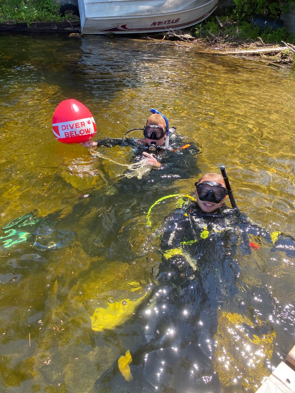
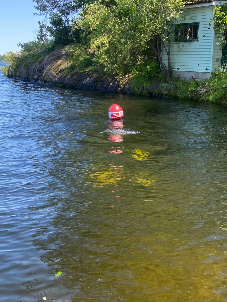
We did a clean up dive with our dive club. Total of 14 divers.
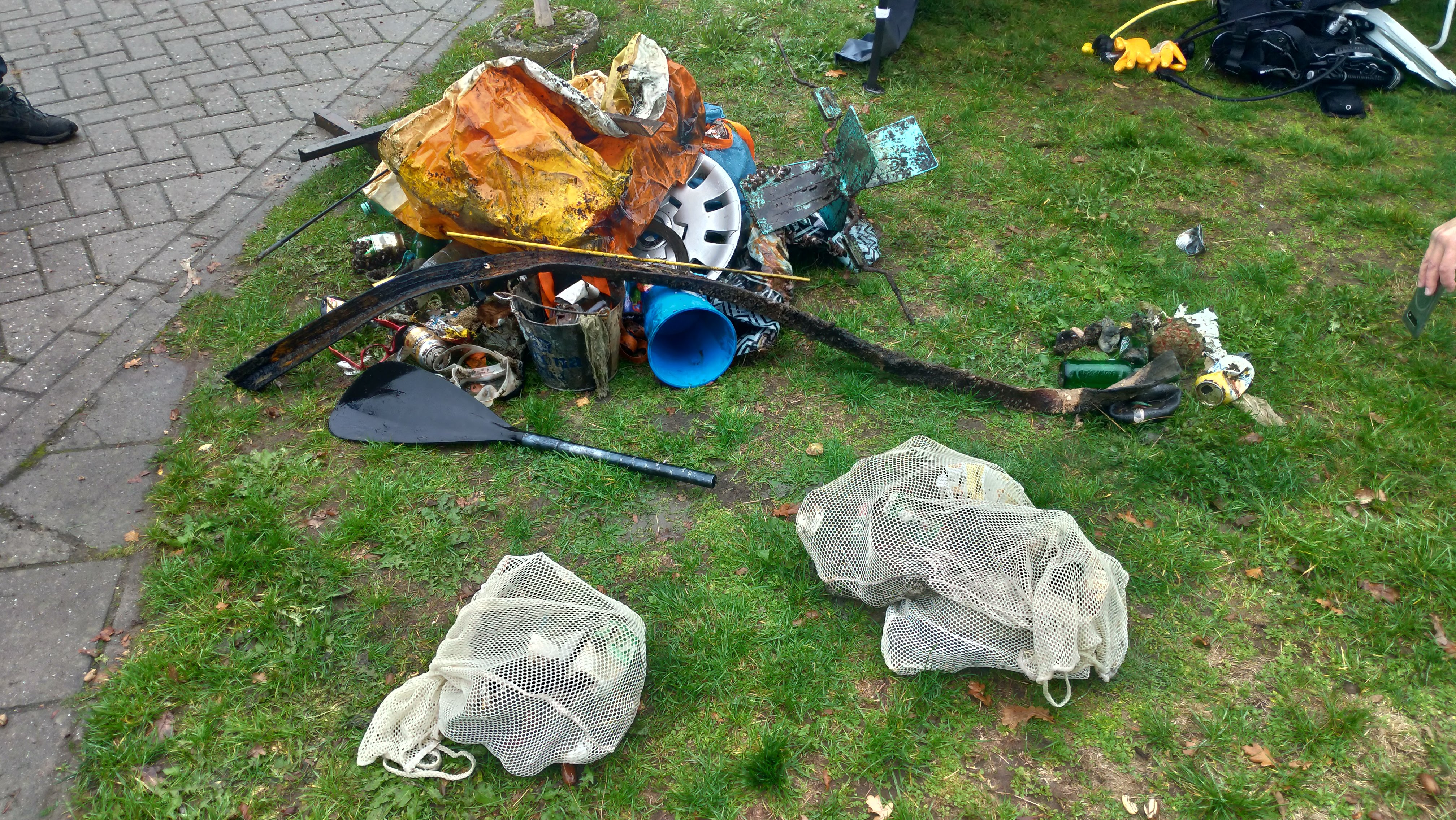
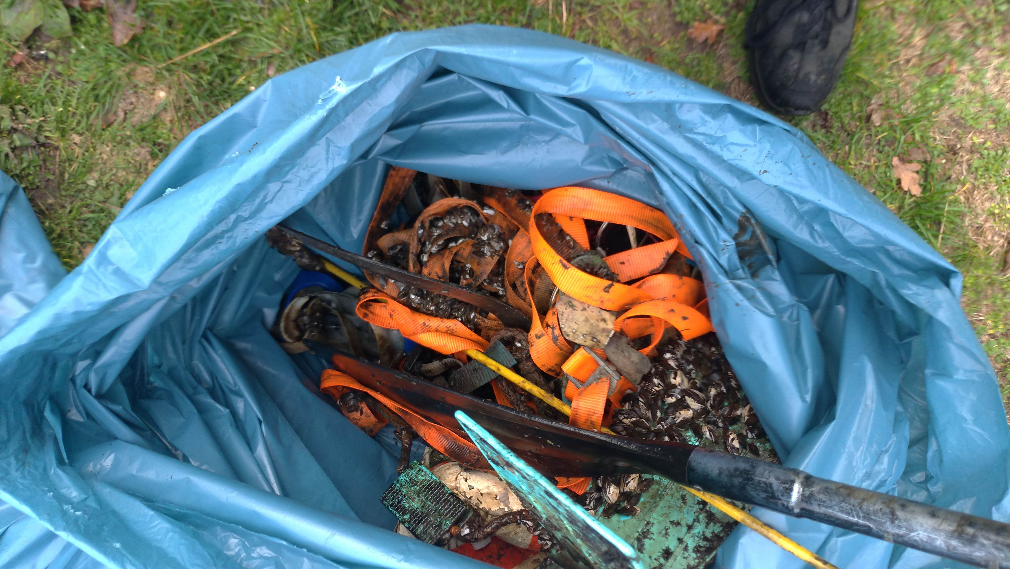
Total amount of debris collected this day was 36,5 kg
Recreation
Maybe add sunglasses to the list.
Wheelcap
Some showers, cloudy and sometimes windy.
1
4
Paddle
Sunglasses
Qdiving
Niels Bosman
2
3
6
2
5
10
4
9
1
1
17.00
61
7.00
1.00
7
measured
3000.00
Plastic bottles
Sunglasses
snorkel/diving gear
On
kilograms
I have debris data to report
9
Calm (glassy to rippled) for waves 0 – 0.1 meter high
2
6
m2
3
meters
other
1
1
1
1
1
10
1
Netherlands
State\Province
Gelderland
City
Voorthuizen
Map Help


Dive Location

If you know your survey site coordinates, enter them manually in decimal degrees using WGS84 Map Datum. Use the minus sign for latitudes south of the equator and longitudes west of the Prime Meridian to 180 degrees.

If you do not know your survey site coordinates, click the “Map Location” tab to use the map to zoom into your survey site and drop the pin on the map to fall within your survey dive site in the water (not on land or the beach). Ensure you zoom in as much as possible to ensure data accuracy.

Entangled Help


Use the vertical tabs below to record any entangled animals you found of each type.

Ecosystem Other
freshwater

Escalvada-Acqua Sub S20005

0
0
0
0

-20.698205070962, -40.405881039449

0
0
0
rock
0
0
0
0
0
No
Good
ACQUA SUB
Ivan Costa Santos
0
0
0
0
0
0
0
0
0
0
0
0
0
0
0
0
0
0
0
8
0
0
0
0
0
0
0
0
0
0
0
0
0
0
0
0
0.00
45
20.00
6.00
0
measured
0
0
2479.29
0
0
0
0
0
0
On
kilograms
0
Our Survey Site was free of debris
0
0
0
Slight for waves 0.5 -1.25 meter high
0
0
0
0
0
0
0
m2
0
0
meters
rocky reef
0
0
0
0
0
0
0
0
0
0
0
0
0
0
0
0
0
0
0
0
0
0
0
0
0
0
0
0
0
Brazil
State\Province
ES
City
Guarapari
Map Help


Dive Location

If you know your survey site coordinates, enter them manually in decimal degrees using WGS84 Map Datum. Use the minus sign for latitudes south of the equator and longitudes west of the Prime Meridian to 180 degrees.

If you do not know your survey site coordinates, click the “Map Location” tab to use the map to zoom into your survey site and drop the pin on the map to fall within your survey dive site in the water (not on land or the beach). Ensure you zoom in as much as possible to ensure data accuracy.

Entangled Help


Use the vertical tabs below to record any entangled animals you found of each type.

Escalvada-Acqua Sub S20005

0
0
0
0

-20.700435997893, -40.407753470404

0
0
0
rock
0
0
0
0
0
No
Cloud
Acqua Sub
Ivan Costa Santos
0
0
0
0
0
0
0
0
0
0
0
0
0
0
0
0
0
0
0
6
0
0
0
0
0
0
0
0
0
0
0
0
0
0
0
0
0.00
80
15.00
9.00
0
measured
0
0
1695.80
0
0
0
0
0
0
On
kilograms
0
Our Survey Site was free of debris
0
0
0
Smooth (wavelets) for waves 0.1 - 0.5 meter high
0
0
0
0
0
0
0
m2
0
0
meters
rocky reef
0
0
0
0
0
0
0
0
0
0
0
0
0
0
0
0
0
0
0
0
0
0
0
0
0
0
0
0
0
Brazil
State\Province
ES
City
Guarapari
Map Help


Dive Location

If you know your survey site coordinates, enter them manually in decimal degrees using WGS84 Map Datum. Use the minus sign for latitudes south of the equator and longitudes west of the Prime Meridian to 180 degrees.

If you do not know your survey site coordinates, click the “Map Location” tab to use the map to zoom into your survey site and drop the pin on the map to fall within your survey dive site in the water (not on land or the beach). Ensure you zoom in as much as possible to ensure data accuracy.

Entangled Help


Use the vertical tabs below to record any entangled animals you found of each type.

Ilhas Rasas - Acqua Sub S20005

0
0
0
0

-20.675784898233, -40.367369411345

0
0
0
gravel
0
0
0
0
0
No
Good
Acqua Sub
Ivan Costa Santos
0
0
0
0
0
0
0
0
0
0
0
0
0
0
0
0
0
0
0
7
0
0
0
0
0
0
0
0
0
0
0
0
0
0
0
0
0.00
40
12.00
5.00
0
measured
0
0
718.45
0
0
0
0
0
0
On
kilograms
0
Our Survey Site was free of debris
0
0
0
Slight for waves 0.5 -1.25 meter high
0
0
0
0
0
0
0
m2
0
0
meters
rocky reef
0
0
0
0
0
0
0
0
0
0
0
0
0
0
0
0
0
0
0
0
0
0
0
0
0
0
0
0
0
Brazil
State\Province
ES
City
Vitória
Map Help


Dive Location

If you know your survey site coordinates, enter them manually in decimal degrees using WGS84 Map Datum. Use the minus sign for latitudes south of the equator and longitudes west of the Prime Meridian to 180 degrees.

If you do not know your survey site coordinates, click the “Map Location” tab to use the map to zoom into your survey site and drop the pin on the map to fall within your survey dive site in the water (not on land or the beach). Ensure you zoom in as much as possible to ensure data accuracy.

Entangled Help


Use the vertical tabs below to record any entangled animals you found of each type.

Brodick Bay Slipway S28852

0
0
0
0

55.577245, -5.144122

0
0
0
sand
0
1
0
0
0
No
Dutch Food Can
Fair
Dive Arran
Rich
0
0
0
0
0
0
0
0
0
0
0
0
0
0
0
0
0
2
0
2
0
0
0
0
0
0
0
0
0
1
0
2
0
0
0
0
1.00
20
4.00
1.00
0
estimated
0
0
0
0
172.87
1
0
0
0
0
Beer Cans
Plastic items
0
On
kilograms
0
I have debris data to report
0
0
0
Smooth (wavelets) for waves 0.1 - 0.5 meter high
0
0
0
0
0
0
0
m2
0
0
meters
rocky reef
0
0
0
0
0
0
0
1
0
0
0
0
0
0
0
0
5
0
0
0
0
0
0
0
0
0
0
0
0
United Kingdom
Map Help


Dive Location

If you know your survey site coordinates, enter them manually in decimal degrees using WGS84 Map Datum. Use the minus sign for latitudes south of the equator and longitudes west of the Prime Meridian to 180 degrees.

If you do not know your survey site coordinates, click the “Map Location” tab to use the map to zoom into your survey site and drop the pin on the map to fall within your survey dive site in the water (not on land or the beach). Ensure you zoom in as much as possible to ensure data accuracy.

Entangled Help


Use the vertical tabs below to record any entangled animals you found of each type.

DROC - Atlantic Princess #2

20

18.369028, -68.852306

coral
multiple wreck fragments after Fiona
Sunny, windy
Coral Point Diving
Edmund Settle
72
12
4
3
3
1
15.00
55
13.00
10.00
6
estimated
60.00
On
kilograms
I have debris data to report
Smooth (wavelets) for waves 0.1 - 0.5 meter high m2
meters
coral reef
1
1
1
Dominican Republic
State\Province
La Altagracia
City
Bayahibe (La Romana)
Map Help


Dive Location

If you know your survey site coordinates, enter them manually in decimal degrees using WGS84 Map Datum. Use the minus sign for latitudes south of the equator and longitudes west of the Prime Meridian to 180 degrees.

If you do not know your survey site coordinates, click the “Map Location” tab to use the map to zoom into your survey site and drop the pin on the map to fall within your survey dive site in the water (not on land or the beach). Ensure you zoom in as much as possible to ensure data accuracy.

Entangled Help


Use the vertical tabs below to record any entangled animals you found of each type.

Hillsboro Reef Mooring Balls #235618

0
0
0
0

26.298383, -80.071542

0
0
0
coral
0
1
0
1
0
Noticeable increase in coral bleaching
Server coral bleaching
Sunny, E/SE winds 10 to 15 mph
Josh Keyser
0
0
0
0
0
0
0
0
0
0
0
0
0
0
0
0
0
0
0
1
0
0
0
0
0
0
0
0
0
0
0
0
0
0
0
0
1.50
45
47.00
32.00
0
estimated
0
0
25000.00
0
0
0
0
0
0
On
pounds
0
I have debris data to report
0
0
0
Smooth (wavelets) for waves 0.1 - 0.5 meter high
0
0
0
0
0
0
0
ft2
0
0
feet
coral reef
0
0
0
0
0
0
0
0
0
0
0
0
0
0
0
0
2
0
0
0
0
0
0
0
0
0
0
0
0
United States
State\Province
FL
City
Hillsboro Beach
Map Help


Dive Location

If you know your survey site coordinates, enter them manually in decimal degrees using WGS84 Map Datum. Use the minus sign for latitudes south of the equator and longitudes west of the Prime Meridian to 180 degrees.

If you do not know your survey site coordinates, click the “Map Location” tab to use the map to zoom into your survey site and drop the pin on the map to fall within your survey dive site in the water (not on land or the beach). Ensure you zoom in as much as possible to ensure data accuracy.

Entangled Help


Use the vertical tabs below to record any entangled animals you found of each type.

Crowe River, Marmora

1

44.484572, -77.686824

1
other
Boat chair that had zebra mussels growing on it
1
1
Paint can
boat chair
Dive Force Scuba
Sarah Boggett
2
2
15.00
20
22.00
8.00
estimated
2000.00
plastic cups
On
pounds
I have debris data to report
Calm (glassy to rippled) for waves 0 – 0.1 meter high
1
ft2
feet
other
Canada
State\Province
ON
City
Belleville
Map Help


Dive Location

If you know your survey site coordinates, enter them manually in decimal degrees using WGS84 Map Datum. Use the minus sign for latitudes south of the equator and longitudes west of the Prime Meridian to 180 degrees.

If you do not know your survey site coordinates, click the “Map Location” tab to use the map to zoom into your survey site and drop the pin on the map to fall within your survey dive site in the water (not on land or the beach). Ensure you zoom in as much as possible to ensure data accuracy.

Entangled Help


Use the vertical tabs below to record any entangled animals you found of each type.

Burleigh Falls, Lakefield

1

44.55813, -78.20335

2
sand
1
Dive Force Scuba
Sarah Boggett
2
1
2
2
1
1
1
7.00
43
35.00
8.00
1
estimated
1
1
1200.00
beverage cans
On
pounds
I have debris data to report
Calm (glassy to rippled) for waves 0 – 0.1 meter high ft2
feet
other
4
Canada
State\Province
ON
City
Trenton
Map Help


Dive Location

If you know your survey site coordinates, enter them manually in decimal degrees using WGS84 Map Datum. Use the minus sign for latitudes south of the equator and longitudes west of the Prime Meridian to 180 degrees.

If you do not know your survey site coordinates, click the “Map Location” tab to use the map to zoom into your survey site and drop the pin on the map to fall within your survey dive site in the water (not on land or the beach). Ensure you zoom in as much as possible to ensure data accuracy.

Entangled Help


Use the vertical tabs below to record any entangled animals you found of each type.

Crowe River, Marmora

1
2
1
other
1

44.449246055486, -77.688738121781

Dive Kawartha
Sarah Boggett
1
1
2
1
4
5.00
20
32.00
5.00
estimated
1
25354.00
1
On
pounds
I have debris data to report
Calm (glassy to rippled) for waves 0 – 0.1 meter high ft2
feet
other
1
3
2
Canada
State\Province
ON
City
Lindsay
Map Help


Dive Location

If you know your survey site coordinates, enter them manually in decimal degrees using WGS84 Map Datum. Use the minus sign for latitudes south of the equator and longitudes west of the Prime Meridian to 180 degrees.

If you do not know your survey site coordinates, click the “Map Location” tab to use the map to zoom into your survey site and drop the pin on the map to fall within your survey dive site in the water (not on land or the beach). Ensure you zoom in as much as possible to ensure data accuracy.

Entangled Help


Use the vertical tabs below to record any entangled animals you found of each type.

Subscribe to