If you know your survey site coordinates, enter them manually in decimal degrees using WGS84 Map Datum. Use the minus sign for latitudes south of the equator and longitudes west of the Prime Meridian to 180 degrees.
If you do not know your survey site coordinates, click the “Map Location” tab to use the map to zoom into your survey site and drop the pin on the map to fall within your survey dive site in the water (not on land or the beach). Ensure you zoom in as much as possible to ensure data accuracy.
Entangled Help
Use the vertical tabs below to record any entangled animals you found of each type.
Smooth (wavelets) for waves 0.1 - 0.5 meter high
ft2
feet
coral reef
United States
State\Province
Fl
City
Islamorada
Map Help
Dive Location
If you know your survey site coordinates, enter them manually in decimal degrees using WGS84 Map Datum. Use the minus sign for latitudes south of the equator and longitudes west of the Prime Meridian to 180 degrees.
If you do not know your survey site coordinates, click the “Map Location” tab to use the map to zoom into your survey site and drop the pin on the map to fall within your survey dive site in the water (not on land or the beach). Ensure you zoom in as much as possible to ensure data accuracy.
Entangled Help
Use the vertical tabs below to record any entangled animals you found of each type.
Smooth (wavelets) for waves 0.1 - 0.5 meter high
ft2
feet
coral reef
United States
State\Province
FL
City
Islamorada
Map Help
Dive Location
If you know your survey site coordinates, enter them manually in decimal degrees using WGS84 Map Datum. Use the minus sign for latitudes south of the equator and longitudes west of the Prime Meridian to 180 degrees.
If you do not know your survey site coordinates, click the “Map Location” tab to use the map to zoom into your survey site and drop the pin on the map to fall within your survey dive site in the water (not on land or the beach). Ensure you zoom in as much as possible to ensure data accuracy.
Entangled Help
Use the vertical tabs below to record any entangled animals you found of each type.
結束バンドは、ダイバーが使用している道具の中にあるものなので、ダイバーの落とし物
その他のごみは、小さく砕けたものだったので、どこからか流されてきたものだと思う (Cable ties are part of the equipment used by divers, so they should not be lost by divers.
The rest of the garbage was small and broken, so I think it was washed away from somewhere.)
Good
6
Cable Ties
SCUBAPROSHOP
YUI FUJIGAMI
2
1
0.50
70
13.00
7.00
estimated
144.00
2
結束バンド (cable ties)
On
kilograms
I have debris data to report
Calm (glassy to rippled) for waves 0 – 0.1 meter high
3
1
m2
meters
rocky reef
Japan
State\Province
TOKYO
City
SHINAGAWA
Map Help
Dive Location
If you know your survey site coordinates, enter them manually in decimal degrees using WGS84 Map Datum. Use the minus sign for latitudes south of the equator and longitudes west of the Prime Meridian to 180 degrees.
If you do not know your survey site coordinates, click the “Map Location” tab to use the map to zoom into your survey site and drop the pin on the map to fall within your survey dive site in the water (not on land or the beach). Ensure you zoom in as much as possible to ensure data accuracy.
Entangled Help
Use the vertical tabs below to record any entangled animals you found of each type.
Calm (glassy to rippled) for waves 0 – 0.1 meter high
2
m2
meters
coral reef
1
1
1
1
2
Indonesia
State\Province
South Sulawesi
City
Bira
Map Help
Dive Location
If you know your survey site coordinates, enter them manually in decimal degrees using WGS84 Map Datum. Use the minus sign for latitudes south of the equator and longitudes west of the Prime Meridian to 180 degrees.
If you do not know your survey site coordinates, click the “Map Location” tab to use the map to zoom into your survey site and drop the pin on the map to fall within your survey dive site in the water (not on land or the beach). Ensure you zoom in as much as possible to ensure data accuracy.
Entangled Help
Use the vertical tabs below to record any entangled animals you found of each type.
Moderate to rough for waves greater than 1.25 meters
m2
1
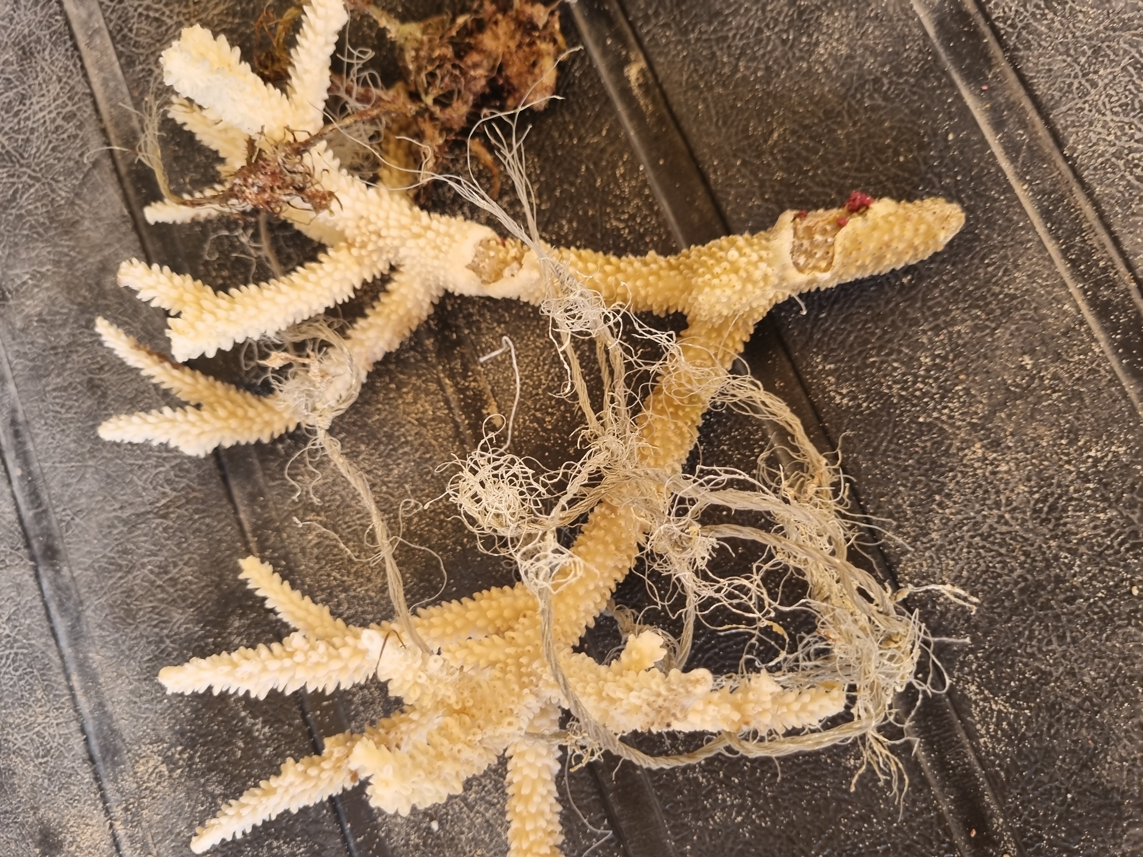
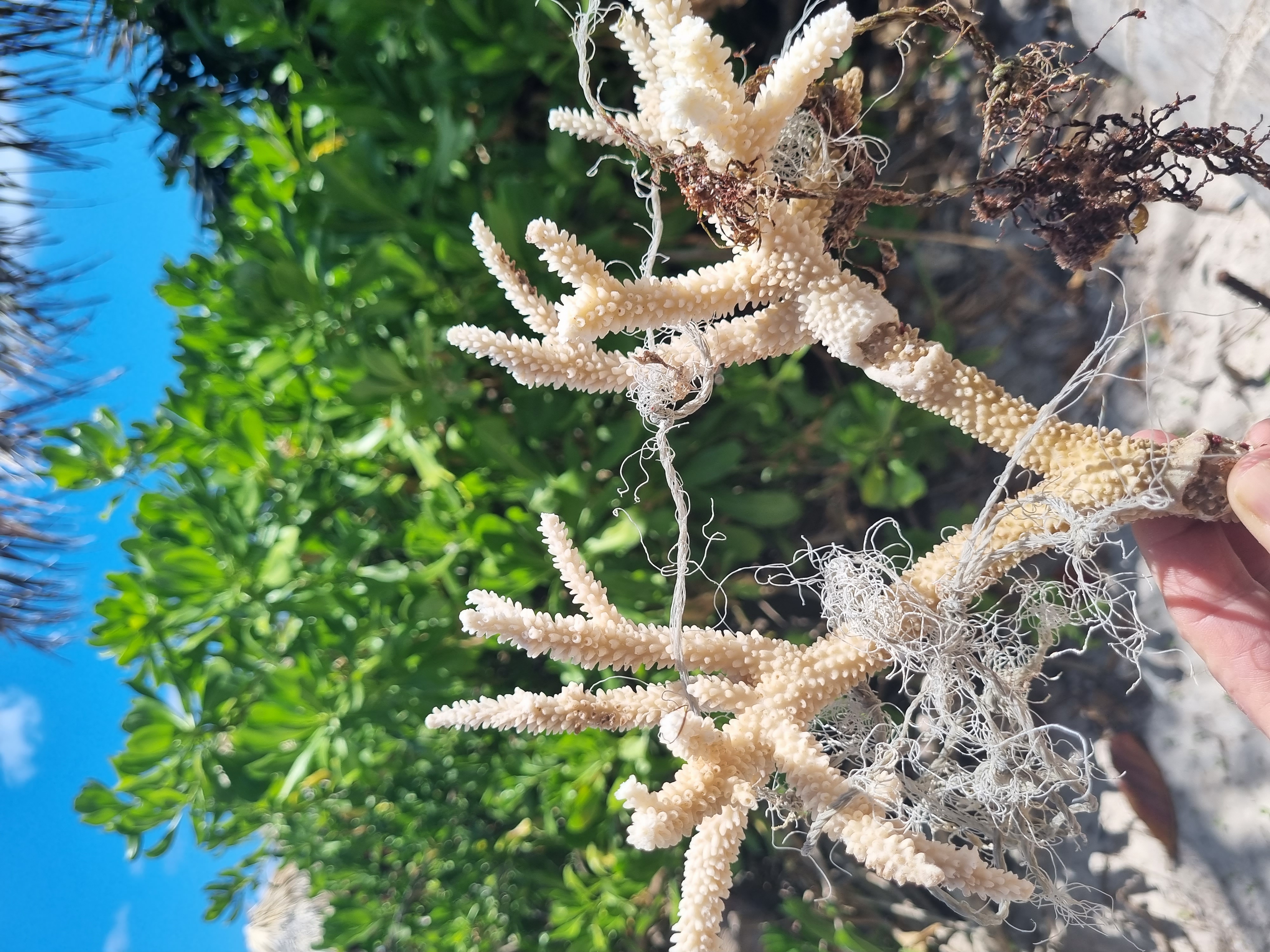
Fishing line
Staghorn coral
Dead
meters
coral reef
Dominican Republic
State\Province
La Altagracia
City
Bavaro Punta Cana
Map Help
Dive Location
If you know your survey site coordinates, enter them manually in decimal degrees using WGS84 Map Datum. Use the minus sign for latitudes south of the equator and longitudes west of the Prime Meridian to 180 degrees.
If you do not know your survey site coordinates, click the “Map Location” tab to use the map to zoom into your survey site and drop the pin on the map to fall within your survey dive site in the water (not on land or the beach). Ensure you zoom in as much as possible to ensure data accuracy.
Entangled Help
Use the vertical tabs below to record any entangled animals you found of each type.
In summer this spot is very popular for a river walk and some beers on the pier. Also the public and tourist boats around that area are contributing to the debris issue. Furthermore the bridge crossing the river at this point is very popular for discarding stolen wallets so we always find some wallets and credit cards in this area.
This bridge and area is also one of the main spots for all large events in Zürich such as the "ZüriFescht" or "Streetparade"
This event was sponsored by TSK Zürich and ERZ Zürich! the entire event was a huge success despite snow rain and the cold. We had about 22 active and tireless divers who collected insane amounts of debris from the riverbed during multiple dives throughout the event as well as 10+ participants for land support who weighet, identified, counted the data.
THANK YOU FOR ALL OF YOUR SUPPORT!
all crayfish could be released unharmed
- desk chair with unicorn design
- baby carriage
- piggy bank
all debris collected from the riverbed that had been there for a few months already was completely covered in fresh water mussels. These were removed out of the water with the debris and could not be released again. They live in the local rivers in abundance and are mostly invasive so a release was not necessary.
were caught between removed cartboardboxes and plastic bags - we were able to release them again and they swam off without any visible issues.
unpredictable and ever changing between rain, snow, sun, wind
4
5
1
1
Umbrella (metal + cloth materials)
Rental E-Scooters (metal + plastic + batteries)
regular scooter (metal + plastic)
Mirror (glas + plastic)
TSK Zürich
Annick + André
1
65
4
2
2
1
1
29
22
8
6
20
496.00
62
9.00
0.50
measured
2
360.00
4
2
2
Any type of bottles (glas bottles, PET plastic bottles, aluminum cans) - Main source of debris in this area
stolen and discarded items such as empty wallets , credit cards , phones
rental e-scooters, since they also have very harmful batteries attached to them
On
kilograms
I have debris data to report
383
Calm (glassy to rippled) for waves 0 – 0.1 meter high
1
8
one of them was found inside the bar table
Released Unharmed
Tiny freshwater fish
common river crayfish
Released Unharmed
3
2
in cartboard and plastic
2
1
1
m2
6
2
9999
on all debris that had been in the riverbed for a while
fresh water mussels
meters
other
35
4
3
3
4
5
2
1
3
24
90
1
7
65
1
2
Switzerland
City
Zürich
Map Help
Dive Location
If you know your survey site coordinates, enter them manually in decimal degrees using WGS84 Map Datum. Use the minus sign for latitudes south of the equator and longitudes west of the Prime Meridian to 180 degrees.
If you do not know your survey site coordinates, click the “Map Location” tab to use the map to zoom into your survey site and drop the pin on the map to fall within your survey dive site in the water (not on land or the beach). Ensure you zoom in as much as possible to ensure data accuracy.
Entangled Help
Use the vertical tabs below to record any entangled animals you found of each type.