Smooth (wavelets) for waves 0.1 - 0.5 meter high
ft2
feet
coral reef
United States
State\Province
FL
City
Islamorada
Map Help
Dive Location
If you know your survey site coordinates, enter them manually in decimal degrees using WGS84 Map Datum. Use the minus sign for latitudes south of the equator and longitudes west of the Prime Meridian to 180 degrees.
If you do not know your survey site coordinates, click the “Map Location” tab to use the map to zoom into your survey site and drop the pin on the map to fall within your survey dive site in the water (not on land or the beach). Ensure you zoom in as much as possible to ensure data accuracy.
Entangled Help
Use the vertical tabs below to record any entangled animals you found of each type.
Calm (glassy to rippled) for waves 0 – 0.1 meter high
ft2
feet
coral reef
United States
State\Province
FL
City
Islamorada
Map Help
Dive Location
If you know your survey site coordinates, enter them manually in decimal degrees using WGS84 Map Datum. Use the minus sign for latitudes south of the equator and longitudes west of the Prime Meridian to 180 degrees.
If you do not know your survey site coordinates, click the “Map Location” tab to use the map to zoom into your survey site and drop the pin on the map to fall within your survey dive site in the water (not on land or the beach). Ensure you zoom in as much as possible to ensure data accuracy.
Entangled Help
Use the vertical tabs below to record any entangled animals you found of each type.
Smooth (wavelets) for waves 0.1 - 0.5 meter high
ft2
feet
coral reef
United States
State\Province
FL
City
Islamorada
Map Help
Dive Location
If you know your survey site coordinates, enter them manually in decimal degrees using WGS84 Map Datum. Use the minus sign for latitudes south of the equator and longitudes west of the Prime Meridian to 180 degrees.
If you do not know your survey site coordinates, click the “Map Location” tab to use the map to zoom into your survey site and drop the pin on the map to fall within your survey dive site in the water (not on land or the beach). Ensure you zoom in as much as possible to ensure data accuracy.
Entangled Help
Use the vertical tabs below to record any entangled animals you found of each type.
Calm (glassy to rippled) for waves 0 – 0.1 meter high
0
0
0
0
0
0
0
m2
1
0
meters
rocky reef
0
0
0
0
0
0
0
0
0
0
0
0
0
0
0
0
0
0
0
0
0
0
0
0
0
0
0
0
0
Spain
State\Province
Girona
City
Sant Feliu de Guixols
Map Help
Dive Location
If you know your survey site coordinates, enter them manually in decimal degrees using WGS84 Map Datum. Use the minus sign for latitudes south of the equator and longitudes west of the Prime Meridian to 180 degrees.
If you do not know your survey site coordinates, click the “Map Location” tab to use the map to zoom into your survey site and drop the pin on the map to fall within your survey dive site in the water (not on land or the beach). Ensure you zoom in as much as possible to ensure data accuracy.
Entangled Help
Use the vertical tabs below to record any entangled animals you found of each type.
If you know your survey site coordinates, enter them manually in decimal degrees using WGS84 Map Datum. Use the minus sign for latitudes south of the equator and longitudes west of the Prime Meridian to 180 degrees.
If you do not know your survey site coordinates, click the “Map Location” tab to use the map to zoom into your survey site and drop the pin on the map to fall within your survey dive site in the water (not on land or the beach). Ensure you zoom in as much as possible to ensure data accuracy.
Entangled Help
Use the vertical tabs below to record any entangled animals you found of each type.
Calm (glassy to rippled) for waves 0 – 0.1 meter high
4
0
0
0
7
0
0
m2
0
0
meters
rocky reef
3
0
0
0
0
1
0
0
0
0
0
0
0
0
0
0
1
0
0
0
0
0
0
0
0
0
0
0
0
Spain
State\Province
Canarias
City
Radazul
Map Help
Dive Location
If you know your survey site coordinates, enter them manually in decimal degrees using WGS84 Map Datum. Use the minus sign for latitudes south of the equator and longitudes west of the Prime Meridian to 180 degrees.
If you do not know your survey site coordinates, click the “Map Location” tab to use the map to zoom into your survey site and drop the pin on the map to fall within your survey dive site in the water (not on land or the beach). Ensure you zoom in as much as possible to ensure data accuracy.
Entangled Help
Use the vertical tabs below to record any entangled animals you found of each type.
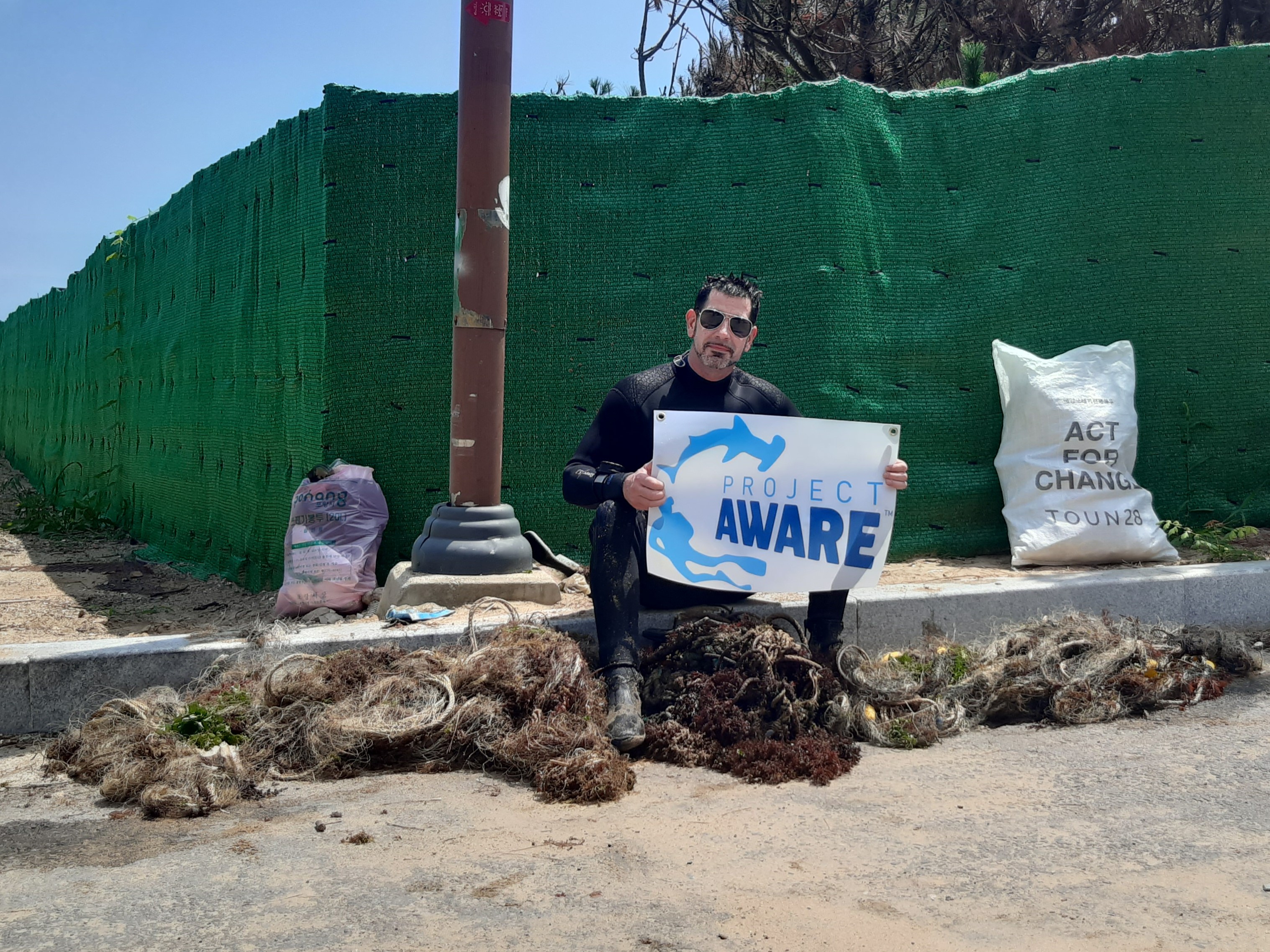
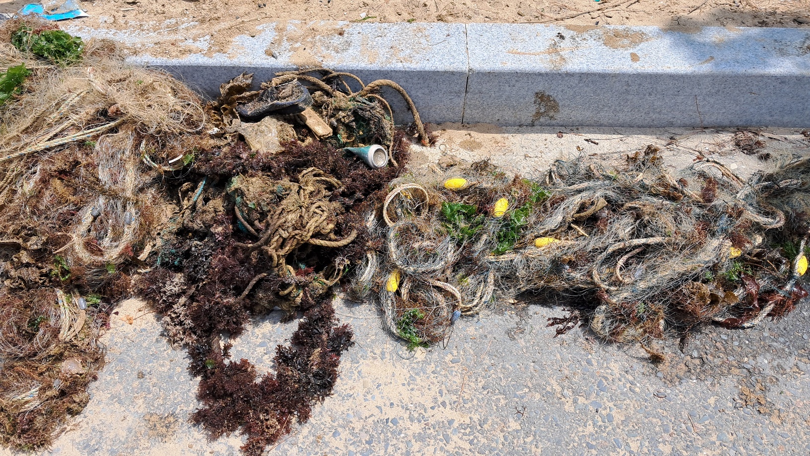
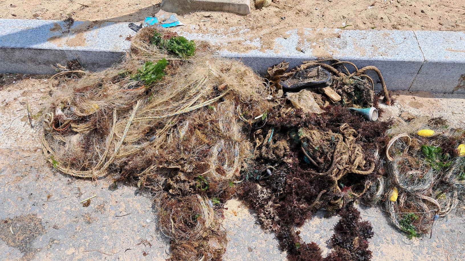
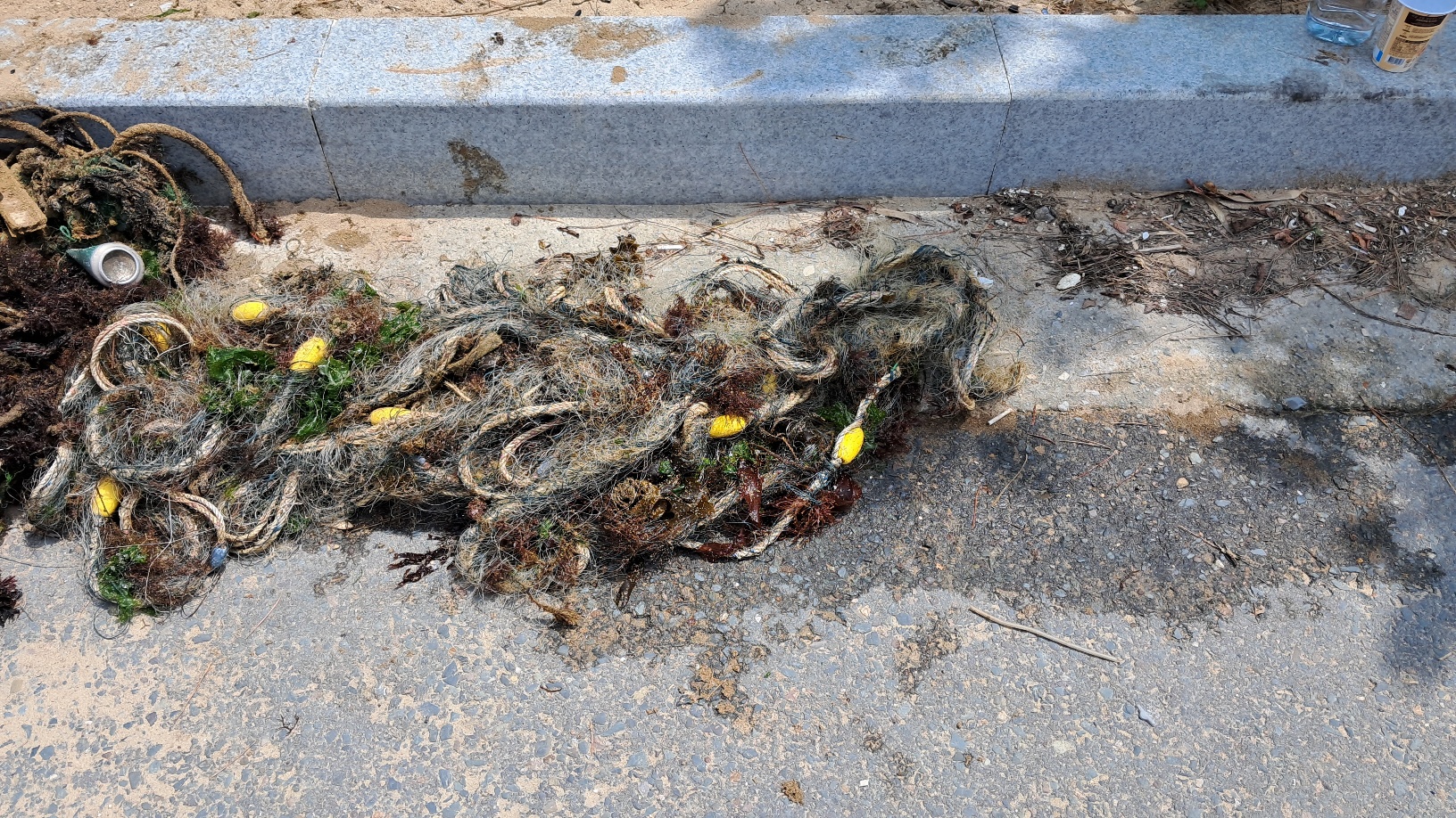
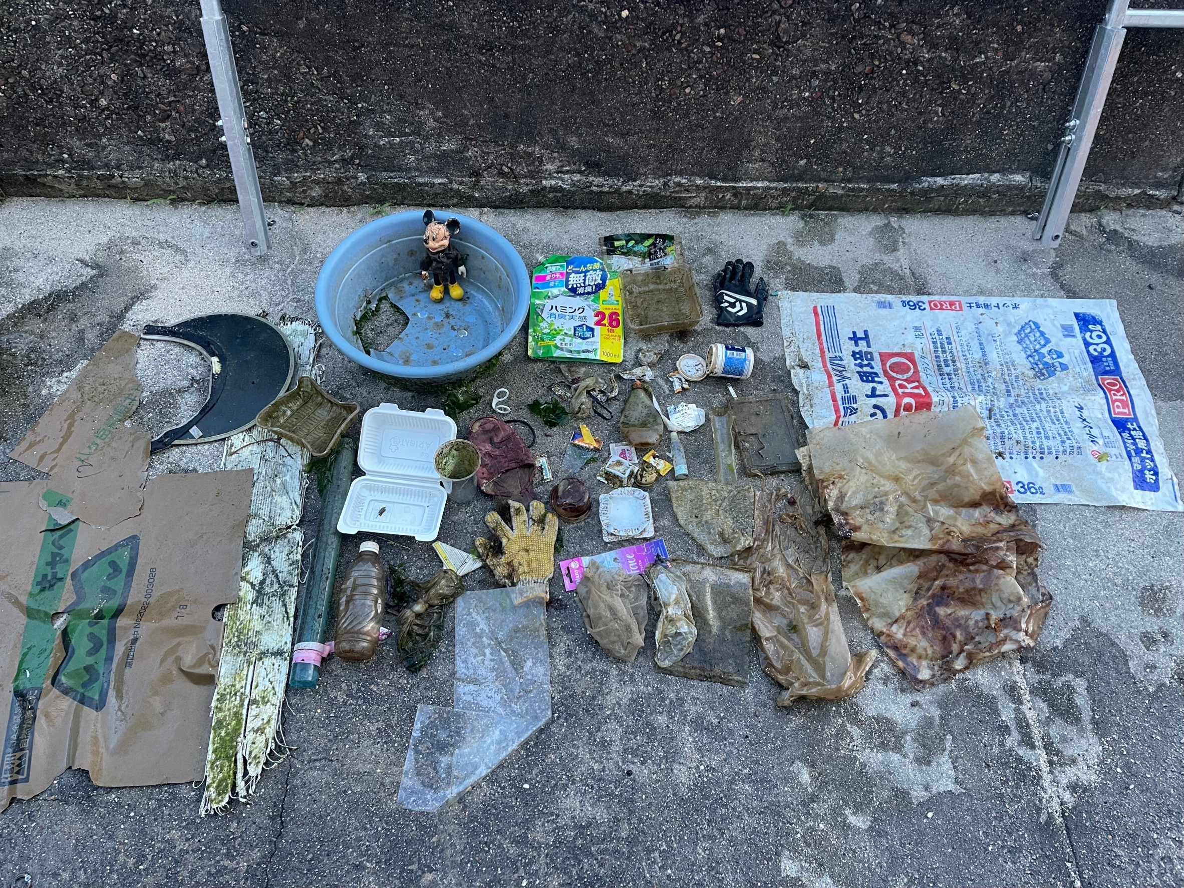
Video of the entire dive here. Point of finding the net begins at the 17 minute mark. Also note the numbers for the foam buoy and metal sinkers that are part of this net are conservative estimates. I didn't actually count them all but their number is plainly seen in the video. https://youtu.be/h6-102V3C2w
I've never seen a net like this stretched out for what seems like over 200 meters. We have had heavy rain but no serious storms
I was doing the survey and found the net. I began following it out to sea hoping to find the end but after a certain point I felt I was too far from shore. I have no idea how much farther it went on. I cut it, and dragged that end back toward the reef. Once at the reef I began collecting (pulling) the other direction and collected it all it all. Initially I tried to cut crabs free but the knife I had was not useful. I took the nets ashore and with the help of some other volunteers cleaning beach trash we were able to
cut free and releases 5 crabs
There were actually many dead animals in the net. This site doesn't allow me to go into detail about animals alive vs Dead, so for statistics I'm reporting the lives saved, but the net contains at least 5 more dead crabs and several dead fish.
Also released 1 entangled starfish and 1 entangled abalone alive
Fishing Net
Very Heavy Rain and localized flooding
Dive Against Debris Korea (Daegu)
William Henderson
1
49
25.00
50
4.00
1.00
19
estimated
103
130.00
fishing net
ropes
On
kilograms
I have debris data to report
Slight for waves 0.5 -1.25 meter high
1
lost fishing net
Several Species for Crab
Released Unharmed
5
2
m2
meters
rocky reef
1
South Korea
State\Province
Gyeongbukdo
City
Pohang
Map Help
Dive Location
If you know your survey site coordinates, enter them manually in decimal degrees using WGS84 Map Datum. Use the minus sign for latitudes south of the equator and longitudes west of the Prime Meridian to 180 degrees.
If you do not know your survey site coordinates, click the “Map Location” tab to use the map to zoom into your survey site and drop the pin on the map to fall within your survey dive site in the water (not on land or the beach). Ensure you zoom in as much as possible to ensure data accuracy.
Entangled Help
Use the vertical tabs below to record any entangled animals you found of each type.