Menu

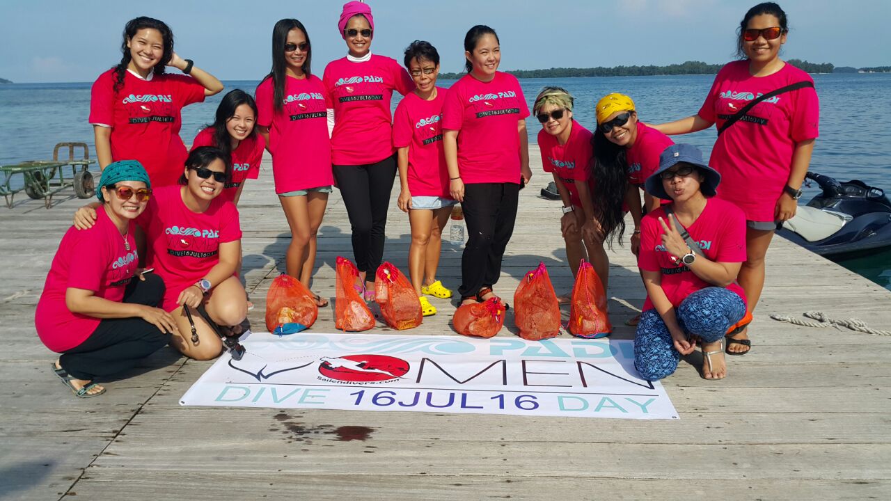
Women's Dive Day Project Aware

59
coral
28

-6.2087634, 106.84559899999999

Sailendivers
Siodin Kho
2
37
12
46
18
20.00
59
18.00
1.00
estimated
500.00
snack packages
plastic bottle
On
kilograms
I have debris data to report
Calm (glassy to rippled) for waves 0 – 0.1 meter high m2
meters
coral reef
Indonesia
State\Province
Banten
City
Tangerang Selatan
Map Help


Dive Location

If you know your survey site coordinates, enter them manually in decimal degrees using WGS84 Map Datum. Use the minus sign for latitudes south of the equator and longitudes west of the Prime Meridian to 180 degrees.

If you do not know your survey site coordinates, click the “Map Location” tab to use the map to zoom into your survey site and drop the pin on the map to fall within your survey dive site in the water (not on land or the beach). Ensure you zoom in as much as possible to ensure data accuracy.

Entangled Help


Use the vertical tabs below to record any entangled animals you found of each type.

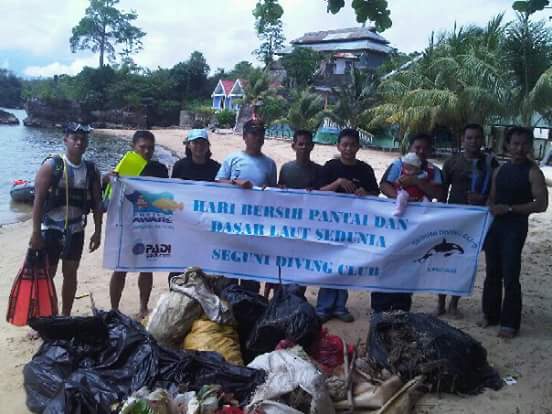
Pantai Kendari (Kendari Beach)

sand

-3.9734542601628857, 122.58784979581833

Seguni Diving Club
Siodin Kho
17
40
9
17
27
19
46
7
2
98.00
180
15.00
2.00
estimated
1600.00
1
Plastic debris
On
kilograms
I have debris data to report
19
Slight for waves 0.5 -1.25 meter high
7
m2
meters
coral reef
4
Indonesia
State\Province
Sulawesi Tenggara
City
Kendari
Map Help


Dive Location

If you know your survey site coordinates, enter them manually in decimal degrees using WGS84 Map Datum. Use the minus sign for latitudes south of the equator and longitudes west of the Prime Meridian to 180 degrees.

If you do not know your survey site coordinates, click the “Map Location” tab to use the map to zoom into your survey site and drop the pin on the map to fall within your survey dive site in the water (not on land or the beach). Ensure you zoom in as much as possible to ensure data accuracy.
Entangled Help


Use the vertical tabs below to record any entangled animals you found of each type.

TEST

sand

51.422485150984, -2.6304963603616

Lou testing
2
10.00
10
5.00
2.00
estimated
10.00
On
kilograms
Our Survey Site was free of debris
Calm (glassy to rippled) for waves 0 – 0.1 meter high m2
meters
coral reef
United Kingdom
Map Help


Dive Location

If you know your survey site coordinates, enter them manually in decimal degrees using WGS84 Map Datum. Use the minus sign for latitudes south of the equator and longitudes west of the Prime Meridian to 180 degrees.

If you do not know your survey site coordinates, click the “Map Location” tab to use the map to zoom into your survey site and drop the pin on the map to fall within your survey dive site in the water (not on land or the beach). Ensure you zoom in as much as possible to ensure data accuracy.

Entangled Help


Use the vertical tabs below to record any entangled animals you found of each type.

Gold Coast Seaway

9
6
5
1

-27.93664, 153.426301

45
rock
3
16000
Mild, hot temperatures. 3mm weather.
1
2
3
Camera Lense
Hats
Sunglasses
Environmental Divers
Kelly Fletcher
15
1
1
3
5
1
1
4
8
3
1
1
6
2
8
2
1
3
1
17.20
65
16.00
1.00
5
measured
1
415
45.00
2
Fishing Line
Lead
Hooks
On
kilograms
I have debris data to report
2
Slight for waves 0.5 -1.25 meter high
2
1
5
m2
6
3
meters
other
2
1
3
3
4
1
7
1
3
1
1
Australia
State\Province
Queensland
City
Brisbane
Map Help


Dive Location

If you know your survey site coordinates, enter them manually in decimal degrees using WGS84 Map Datum. Use the minus sign for latitudes south of the equator and longitudes west of the Prime Meridian to 180 degrees.

If you do not know your survey site coordinates, click the “Map Location” tab to use the map to zoom into your survey site and drop the pin on the map to fall within your survey dive site in the water (not on land or the beach). Ensure you zoom in as much as possible to ensure data accuracy.

Entangled Help


Use the vertical tabs below to record any entangled animals you found of each type.

Ecosystem Other
Man made seaway entrance, rock wall with sand bottom

Gold Coast Seaway

11
19
5
1

-27.93664, 153.426301

32
rock
1
1
17000
Moderate
1
5
Hats
Socks
Environmental Divers
Kelly Fletcher
1
9
1
7
1
1
4
9
5
2
3
4
3
7
3
2
1
7
2
1
17.20
82
19.00
2.00
3
measured
2
311
90.00
2
Fishing Line
Lead
Hooks
On
kilograms
I have debris data to report
3
Slight for waves 0.5 -1.25 meter high
1
1
6
1
m2
2
meters
other
2
9
3
9
1
3
1
1
1
Australia
State\Province
Queensland
City
Brisbane
Map Help


Dive Location

If you know your survey site coordinates, enter them manually in decimal degrees using WGS84 Map Datum. Use the minus sign for latitudes south of the equator and longitudes west of the Prime Meridian to 180 degrees.

If you do not know your survey site coordinates, click the “Map Location” tab to use the map to zoom into your survey site and drop the pin on the map to fall within your survey dive site in the water (not on land or the beach). Ensure you zoom in as much as possible to ensure data accuracy.

Entangled Help


Use the vertical tabs below to record any entangled animals you found of each type.

Ecosystem Other
Man made seaway entrance, rock wall with sand bottom

Gold Coast Seaway

9
17
7
3

-27.93664, 153.426301

42
rock
3
15000
3
FINE
2
Sunglasses
Environmental Divers
Kelly Fletcher
9
1
1
9
7
8
3
4
1
2
2
3
2
1
1
2
3
19.20
74
21.00
3.00
3
measured
1
512
40.00
1
Fishing Line
Lead
Hooks
On
kilograms
I have debris data to report
9
Slight for waves 0.5 -1.25 meter high
1
4
m2
3
1
meters
other
2
4
1
6
1
6
1
5
9
1
Australia
State\Province
Queensland
City
Brisbane
Map Help


Dive Location

If you know your survey site coordinates, enter them manually in decimal degrees using WGS84 Map Datum. Use the minus sign for latitudes south of the equator and longitudes west of the Prime Meridian to 180 degrees.

If you do not know your survey site coordinates, click the “Map Location” tab to use the map to zoom into your survey site and drop the pin on the map to fall within your survey dive site in the water (not on land or the beach). Ensure you zoom in as much as possible to ensure data accuracy.

Entangled Help


Use the vertical tabs below to record any entangled animals you found of each type.

Ecosystem Other
Man made seaway entrance, rock wall with sand bottom

Gold Coast Seaway

9
12
7
5

-27.93664, 153.426301

47
rock
2
15000
1
FINE
1
5
Hats
Sunglasses
Environmental Divers
Kelly Fletcher
1
4
9
1
7
19
1
1
5
3
17
4
7
1
7
9
9
5
3
2
36.50
98
8.00
1.00
9
measured
3
2176
50.00
8
Fishing Line
Lead
Hooks
On
kilograms
I have debris data to report
8
Slight for waves 0.5 -1.25 meter high
1
1
1
4
m2
2
5
meters
other
2
1
7
7
2
6
1
11
9
7
1
3
1
Australia
State\Province
Queensland
City
Brisbane
Map Help


Dive Location

If you know your survey site coordinates, enter them manually in decimal degrees using WGS84 Map Datum. Use the minus sign for latitudes south of the equator and longitudes west of the Prime Meridian to 180 degrees.

If you do not know your survey site coordinates, click the “Map Location” tab to use the map to zoom into your survey site and drop the pin on the map to fall within your survey dive site in the water (not on land or the beach). Ensure you zoom in as much as possible to ensure data accuracy.

Entangled Help


Use the vertical tabs below to record any entangled animals you found of each type.

Ecosystem Other
Man made seaway entrance, rock wall with sand bottom

Gold Coast Seaway

25
9
12
1

-27.93664, 153.426301

7
rock
2
7
12000
FINE
1
3
3
1
Hats
Fake Flowers
Fake Christmas Tree Limbs
Pirate Eye Patch
Environmental Divers
Kelly Fletcher
3
9
7
1
4
23
1
1
2
8
7
7
9
7
2
9
6
1
7
2
2
48.00
65
17.00
2.00
7
measured
2
1
30.00
5
Fishing Line
Lead
Hooks
On
kilograms
I have debris data to report
7
Smooth (wavelets) for waves 0.1 - 0.5 meter high
3
1
2
9
3
m2
6
meters
other
2
1
7
17
7
2
1
5
2
2
Australia
State\Province
Queensland
City
Brisbane
Map Help


Dive Location

If you know your survey site coordinates, enter them manually in decimal degrees using WGS84 Map Datum. Use the minus sign for latitudes south of the equator and longitudes west of the Prime Meridian to 180 degrees.

If you do not know your survey site coordinates, click the “Map Location” tab to use the map to zoom into your survey site and drop the pin on the map to fall within your survey dive site in the water (not on land or the beach). Ensure you zoom in as much as possible to ensure data accuracy.

Entangled Help


Use the vertical tabs below to record any entangled animals you found of each type.

Ecosystem Other
Man made seaway entrance, rock wall with sand bottom

Gold Coast Seaway

18
6
6
3

-27.93664, 153.426301

29
rock
4
4
1
9000
1
Removed hook and line and released fish.
Fine
3
Hats
Environmental Divers
Kelly Fletcher
2
9
17
1
7
1
25
2
1
1
2
5
5
5
2
1
3
2
7
6
6
2
3
2
2
27.00
77
8.00
1.00
8
measured
2
2
1782
20.00
3
Fishing Line
Lead
Hooks
On
kilograms
I have debris data to report
4
Smooth (wavelets) for waves 0.1 - 0.5 meter high
3
3
Hook and line entangled
2
Released Unharmed
Brim
3
7
1
1
m2
9
4
meters
other
2
1
5
2
5
1
11
1
5
4
21
1
7
4
3
Australia
State\Province
Queensland
City
Brisbane
Map Help


Dive Location

If you know your survey site coordinates, enter them manually in decimal degrees using WGS84 Map Datum. Use the minus sign for latitudes south of the equator and longitudes west of the Prime Meridian to 180 degrees.

If you do not know your survey site coordinates, click the “Map Location” tab to use the map to zoom into your survey site and drop the pin on the map to fall within your survey dive site in the water (not on land or the beach). Ensure you zoom in as much as possible to ensure data accuracy.

Entangled Help


Use the vertical tabs below to record any entangled animals you found of each type.

Ecosystem Other
Man made seaway entrance, rock wall with sand bottom

ADS01 - Lighthouse Bay

10.1204061950413, 99.8441778123378

coral
Calm conditions
Sunshine Divers
Lara Maassen
1
7
5
15
3.00
45
9.00
3.00
estimated
100.00
1
Plastic Bottles
On
kilograms
I have debris data to report
Calm (glassy to rippled) for waves 0 – 0.1 meter high m2
meters
coral reef
Thailand
State\Province
Surat Thani
City
Koh Tao
Map Help


Dive Location

If you know your survey site coordinates, enter them manually in decimal degrees using WGS84 Map Datum. Use the minus sign for latitudes south of the equator and longitudes west of the Prime Meridian to 180 degrees.

If you do not know your survey site coordinates, click the “Map Location” tab to use the map to zoom into your survey site and drop the pin on the map to fall within your survey dive site in the water (not on land or the beach). Ensure you zoom in as much as possible to ensure data accuracy.

Entangled Help


Use the vertical tabs below to record any entangled animals you found of each type.

Subscribe to