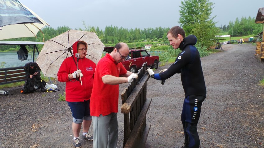
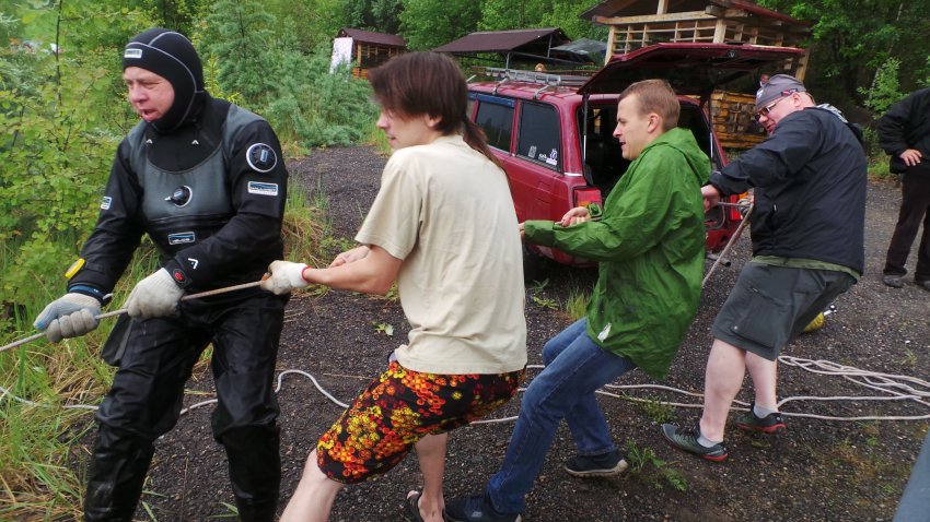
Total number of participants including land support over 80 persons
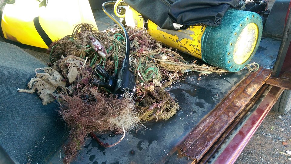
Part of surfboard, Spinning rot, Car door
Air temperature +22/+24
Rainy
Water temperature +16/+10/+3
Underwater visiblity 1,5 - 3 m
Spinning
RuDIVE
Alexey Sergeev
15
43
2
4
4
3
1
1663.00
39
16.00
2.00
2
measured
850.00
10
Plastic bags and trays, bacause fish may eat it
Car parts, because people can get hurt
Fishing line, because it dangerous for animals, people and divers
On
kilograms
I have debris data to report
3
10
Calm (glassy to rippled) for waves 0 – 0.1 meter high
20
1
m2
meters
other
50
6
2
6
10
1
Russia
City
Moscow
Map Help
Dive Location
If you know your survey site coordinates, enter them manually in decimal degrees using WGS84 Map Datum. Use the minus sign for latitudes south of the equator and longitudes west of the Prime Meridian to 180 degrees.
If you do not know your survey site coordinates, click the “Map Location” tab to use the map to zoom into your survey site and drop the pin on the map to fall within your survey dive site in the water (not on land or the beach). Ensure you zoom in as much as possible to ensure data accuracy.
Entangled Help
Use the vertical tabs below to record any entangled animals you found of each type.
Calm (glassy to rippled) for waves 0 – 0.1 meter high
2
ft2
feet
other
3
1
1
3
12
4
Language
English
United States
State\Province
NV.
City
Las Vegas
Map Help
Dive Location
If you know your survey site coordinates, enter them manually in decimal degrees using WGS84 Map Datum. Use the minus sign for latitudes south of the equator and longitudes west of the Prime Meridian to 180 degrees.
If you do not know your survey site coordinates, click the “Map Location” tab to use the map to zoom into your survey site and drop the pin on the map to fall within your survey dive site in the water (not on land or the beach). Ensure you zoom in as much as possible to ensure data accuracy.
Entangled Help
Use the vertical tabs below to record any entangled animals you found of each type.
was caught in net of fish trap to gills & had to cut free, had a small incision on side of gills when released, stunned & shocked but took off once it became aware of being free while held in water
Sunny & fine with slight current at surface
Save Cambodian Marine Life
Dianne Martyn
1
1
1
1
4
2
1
4
2
6
100.00
50
5.70
5.50
3
estimated
3
8
8.00
nets covering coral & reef
On
kilograms
I have debris data to report
3
Smooth (wavelets) for waves 0.1 - 0.5 meter high
3
net found on coral reef
Injured
parrot fish
small crabs
Released Unharmed
2
1
fish trap
2
3
m2
4
8
meters
coral reef
2
1
1
2
2
1
3
Language
English
Cambodia
State\Province
Koh Rong Samloem
City
M'Pai Bay
Map Help
Dive Location
If you know your survey site coordinates, enter them manually in decimal degrees using WGS84 Map Datum. Use the minus sign for latitudes south of the equator and longitudes west of the Prime Meridian to 180 degrees.
If you do not know your survey site coordinates, click the “Map Location” tab to use the map to zoom into your survey site and drop the pin on the map to fall within your survey dive site in the water (not on land or the beach). Ensure you zoom in as much as possible to ensure data accuracy.
Entangled Help
Use the vertical tabs below to record any entangled animals you found of each type.
cut out with scissors on boat & then relaeased unharmed
Very severe current under water and cloudy windy day
Had to abort the dive after 14 minutes as current was not allowing us to stay in one place to collect debris, however collected debris at boat level when we returned to surface - as it went by with the current.
Save Cambodian Marine Life
Dianne Martyn
2
2
1
9.95
34
7.50
1.00
1
estimated
6.00
nets covering the coral on the reef
On
kilograms
I have debris data to report
1
Slight for waves 0.5 -1.25 meter high
fine mesh fishing net
Small crabs
Released Unharmed
2
m2
1
meters
coral reef
1
2
1
Language
English
Cambodia
State\Province
Koh Rong Samloem
City
M'Pai Bay
Map Help
Dive Location
If you know your survey site coordinates, enter them manually in decimal degrees using WGS84 Map Datum. Use the minus sign for latitudes south of the equator and longitudes west of the Prime Meridian to 180 degrees.
If you do not know your survey site coordinates, click the “Map Location” tab to use the map to zoom into your survey site and drop the pin on the map to fall within your survey dive site in the water (not on land or the beach). Ensure you zoom in as much as possible to ensure data accuracy.
Entangled Help
Use the vertical tabs below to record any entangled animals you found of each type.
fishermen throwing out over side of boats, nets & fishing gear from fishing boats
cut out with scissor & released unharmed
Windy overcast
Save Cambodian Marine Life
Dianne martyn
2
2
1
6.81
45
2.50
1.00
estimated
5.00
On
kilograms
I have debris data to report
Smooth (wavelets) for waves 0.1 - 0.5 meter high
fine net
Micro crab
Released Unharmed
1
1
m2
1
meters
rocky reef
1
1
Language
English
Cambodia
State\Province
Koh Rong Samloem
City
M'Pai Bay
Map Help
Dive Location
If you know your survey site coordinates, enter them manually in decimal degrees using WGS84 Map Datum. Use the minus sign for latitudes south of the equator and longitudes west of the Prime Meridian to 180 degrees.
If you do not know your survey site coordinates, click the “Map Location” tab to use the map to zoom into your survey site and drop the pin on the map to fall within your survey dive site in the water (not on land or the beach). Ensure you zoom in as much as possible to ensure data accuracy.
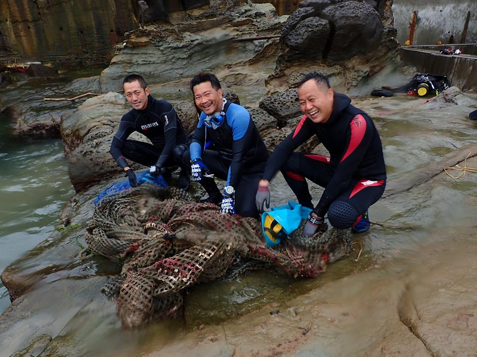
Entangled Help
Use the vertical tabs below to record any entangled animals you found of each type.
Calm (glassy to rippled) for waves 0 – 0.1 meter high
5
m2
meters
seagrass
5
23
6
2
4
3
Language
English
Greece
State\Province
Loutraki
City
Loutraki
Map Help
Dive Location
If you know your survey site coordinates, enter them manually in decimal degrees using WGS84 Map Datum. Use the minus sign for latitudes south of the equator and longitudes west of the Prime Meridian to 180 degrees.
If you do not know your survey site coordinates, click the “Map Location” tab to use the map to zoom into your survey site and drop the pin on the map to fall within your survey dive site in the water (not on land or the beach). Ensure you zoom in as much as possible to ensure data accuracy.
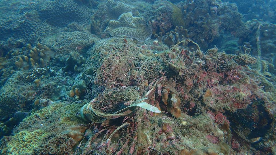
Entangled Help
Use the vertical tabs below to record any entangled animals you found of each type.
Smooth (wavelets) for waves 0.1 - 0.5 meter high
m2
meters
coral reef
Language
English
Indonesia
State\Province
Bali
City
Sanur
Map Help
Dive Location
If you know your survey site coordinates, enter them manually in decimal degrees using WGS84 Map Datum. Use the minus sign for latitudes south of the equator and longitudes west of the Prime Meridian to 180 degrees.
If you do not know your survey site coordinates, click the “Map Location” tab to use the map to zoom into your survey site and drop the pin on the map to fall within your survey dive site in the water (not on land or the beach). Ensure you zoom in as much as possible to ensure data accuracy.
Entangled Help
Use the vertical tabs below to record any entangled animals you found of each type.
Calm (glassy to rippled) for waves 0 – 0.1 meter high
m2
meters
coral reef
Language
English
Taiwan
City
new taipei city
Map Help
Dive Location
If you know your survey site coordinates, enter them manually in decimal degrees using WGS84 Map Datum. Use the minus sign for latitudes south of the equator and longitudes west of the Prime Meridian to 180 degrees.
If you do not know your survey site coordinates, click the “Map Location” tab to use the map to zoom into your survey site and drop the pin on the map to fall within your survey dive site in the water (not on land or the beach). Ensure you zoom in as much as possible to ensure data accuracy.
Entangled Help
Use the vertical tabs below to record any entangled animals you found of each type.
Smooth (wavelets) for waves 0.1 - 0.5 meter high
m2
meters
coral reef
Language
English
Taiwan
City
new taipei city
Map Help
Dive Location
If you know your survey site coordinates, enter them manually in decimal degrees using WGS84 Map Datum. Use the minus sign for latitudes south of the equator and longitudes west of the Prime Meridian to 180 degrees.
If you do not know your survey site coordinates, click the “Map Location” tab to use the map to zoom into your survey site and drop the pin on the map to fall within your survey dive site in the water (not on land or the beach). Ensure you zoom in as much as possible to ensure data accuracy.
Entangled Help
Use the vertical tabs below to record any entangled animals you found of each type.