Menu

Dhiffushi Lagoon

2
2

751, 252

sand
1
3
3
5
2
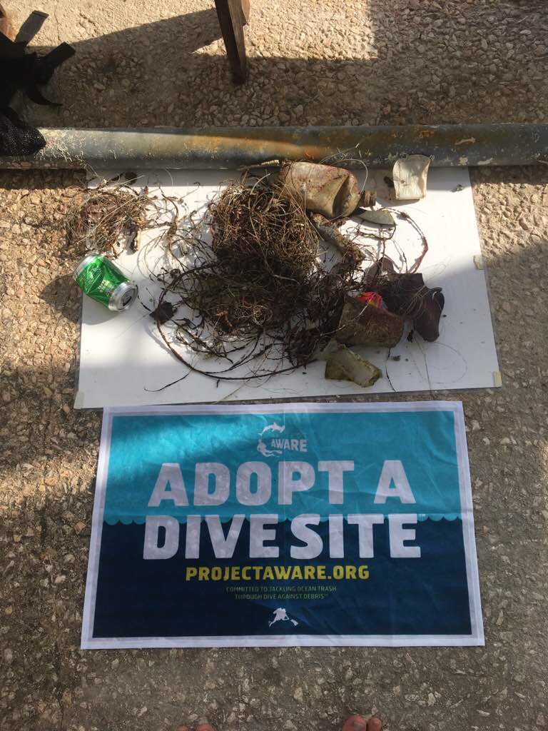
Even we have regular clean ups on the island we were quit surprised how much is still there. We want to say thank you to our guests. We hope that everyone takes a bit more awarness home and share it with others.
winds around 45 mph, waves
Diveoceanus Holiday island
Sharif
1
13
2
4
1
3
2
2
1
4
1
3
5.00
30
3.00
1.00
2
estimated
10.00
2
1
-2
plastics
metal
styrofoam
On
kilograms
I have debris data to report
1
2
Calm (glassy to rippled) for waves 0 – 0.1 meter high
3
3
2
m2
meters
other
1
4
1
2
2
2
1
3
1
2
1
2
Maldives
Map Help


Dive Location

If you know your survey site coordinates, enter them manually in decimal degrees using WGS84 Map Datum. Use the minus sign for latitudes south of the equator and longitudes west of the Prime Meridian to 180 degrees.

If you do not know your survey site coordinates, click the “Map Location” tab to use the map to zoom into your survey site and drop the pin on the map to fall within your survey dive site in the water (not on land or the beach). Ensure you zoom in as much as possible to ensure data accuracy.

Entangled Help


Use the vertical tabs below to record any entangled animals you found of each type.

Ecosystem Other
Lagoon sandy with some coral blocks

ADS310 - Karangsari

42
9
10

-8.706028, 115.5855

coral
1
6
1
Previous weeks of strong wind and waves
Backpack
Windy, large waves
1
Backpack
Blue Corner Dive
Made Partayasa
22
46
3
5
5
8
20.00
55
20.00
7.00
53
measured
50.00
Wrapper (foil/metal)
Rope (plastic/nylon)
Plastic Fragments
On
kilograms
I have debris data to report
Smooth (wavelets) for waves 0.1 - 0.5 meter high
2
27
m2
meters
coral reef
91
Indonesia
State\Province
Bali
Map Help


Dive Location

If you know your survey site coordinates, enter them manually in decimal degrees using WGS84 Map Datum. Use the minus sign for latitudes south of the equator and longitudes west of the Prime Meridian to 180 degrees.

If you do not know your survey site coordinates, click the “Map Location” tab to use the map to zoom into your survey site and drop the pin on the map to fall within your survey dive site in the water (not on land or the beach). Ensure you zoom in as much as possible to ensure data accuracy.

Entangled Help


Use the vertical tabs below to record any entangled animals you found of each type.

Halfmoon Al Khobar Eastern Saudi Arabia

4
seagrass
5

26.128455577472, 49.996225639403

Learning/discovering the pleasure of diving and its importance. As new open water divers, our eyes were opened-up on how we can participate in saving our ocean. Continue sending your ads, Project Aware and Padi, you are the reason why we admire your act.
Wind Gust: 21-22 kph
MacDivers
R Jay R. Dela Cruz
7
1
3
23
6
12.00
40
27.00
8.00
estimated
1500.00
On
kilograms
I have debris data to report
Calm (glassy to rippled) for waves 0 – 0.1 meter high m2
feet
seagrass
7
Saudi Arabia
State\Province
Eastern Region
City
Al Khobar
Map Help


Dive Location

If you know your survey site coordinates, enter them manually in decimal degrees using WGS84 Map Datum. Use the minus sign for latitudes south of the equator and longitudes west of the Prime Meridian to 180 degrees.

If you do not know your survey site coordinates, click the “Map Location” tab to use the map to zoom into your survey site and drop the pin on the map to fall within your survey dive site in the water (not on land or the beach). Ensure you zoom in as much as possible to ensure data accuracy.

Entangled Help


Use the vertical tabs below to record any entangled animals you found of each type.

ADS324 - Stella Maris Mambo Beach

0
0
0

12.083101781253, -68.90184739396

2
0
0
sand
0
0
0
50
0
Maxi pad
Sunny with decent wind
0
0
0
0
0
0
0
0
0
0
0
0
0
0
0
0
0
0
0
0
Ocean Encounters
Shane Wever
0
1
0
2
0
0
0
0
0
0
0
0
0
0
0
0
0
0
0
14
0
0
0
0
0
0
0
0
0
0
0
0
0
0
3.00
61
25.00
9.00
2
estimated
0
10
3901.86
0
0
0
0
0
Fishing line
Plastic cups
Hooks
0
On
kilograms
0
I have debris data to report
0
0
0
Slight for waves 0.5 -1.25 meter high
0
0
0
0
0
0
0
m2
0
0
feet
coral reef
0
0
0
0
0
0
0
0
0
0
0
0
0
0
0
0
1
0
0
0
0
0
0
0
0
0
0
0
Netherlands Antilles
State\Province
Curaçao
City
Willemstad
Map Help


Dive Location

If you know your survey site coordinates, enter them manually in decimal degrees using WGS84 Map Datum. Use the minus sign for latitudes south of the equator and longitudes west of the Prime Meridian to 180 degrees.

If you do not know your survey site coordinates, click the “Map Location” tab to use the map to zoom into your survey site and drop the pin on the map to fall within your survey dive site in the water (not on land or the beach). Ensure you zoom in as much as possible to ensure data accuracy.

Entangled Help


Use the vertical tabs below to record any entangled animals you found of each type.

ADS345 - Divewise House Reef

12

35.924292, 14.493816

rock
150
calm
DivewiseMalta
Sarah Shaw
12
3
3
1
12.00
71
8.00
2.00
estimated
1
3391.00
3
glass
On
kilograms
I have debris data to report
9
Smooth (wavelets) for waves 0.1 - 0.5 meter high
2
1
m2
meters
rocky reef
4
3
1
4
2
1
74
Malta
City
St julians
Map Help


Dive Location

If you know your survey site coordinates, enter them manually in decimal degrees using WGS84 Map Datum. Use the minus sign for latitudes south of the equator and longitudes west of the Prime Meridian to 180 degrees.

If you do not know your survey site coordinates, click the “Map Location” tab to use the map to zoom into your survey site and drop the pin on the map to fall within your survey dive site in the water (not on land or the beach). Ensure you zoom in as much as possible to ensure data accuracy.

Entangled Help


Use the vertical tabs below to record any entangled animals you found of each type.

Tugboat

1
2
0
0

12.069648, -68.862208

0
0
0
coral
0
0
0
12
0
Fishing
Sunny windy
The Dive Bus
Bor
0
0
0
0
0
0
0
0
0
0
0
0
0
0
0
0
0
0
0
2
0
0
0
0
0
0
0
0
0
0
0
0
0
0
0
0
1.00
63
23.00
2.00
0
measured
0
0
0
0
20.00
0
0
0
3
0
Fishing line
0
On
pounds
0
I have debris data to report
1
0
0
Smooth (wavelets) for waves 0.1 - 0.5 meter high
0
0
0
0
0
0
0
m2
0
0
meters
coral reef
0
0
0
0
0
0
0
0
0
0
0
0
0
0
0
0
0
0
0
0
0
0
1
0
0
0
0
1
0
Netherlands Antilles
City
Willemstad
Map Help


Dive Location

If you know your survey site coordinates, enter them manually in decimal degrees using WGS84 Map Datum. Use the minus sign for latitudes south of the equator and longitudes west of the Prime Meridian to 180 degrees.

If you do not know your survey site coordinates, click the “Map Location” tab to use the map to zoom into your survey site and drop the pin on the map to fall within your survey dive site in the water (not on land or the beach). Ensure you zoom in as much as possible to ensure data accuracy.

Entangled Help


Use the vertical tabs below to record any entangled animals you found of each type.

ADS272 - Skår Gullmarn

0
2
0
0

58.297812, 11.531132

0
0
0
silt
0
1
0
0
0
Windy and rain
Oxygene Diving i Göteborg AB
Anna Viker
0
0
0
1
0
0
0
0
1
0
0
0
0
0
0
0
0
0
0
2
0
0
0
0
0
0
0
0
0
0
0
0
0
0
0
0
0.40
40
28.00
4.00
0
estimated
0
0
0
0
200.00
0
0
0
0
0
1
On
kilograms
0
I have debris data to report
0
0
0
Smooth (wavelets) for waves 0.1 - 0.5 meter high
0
0
0
0
0
0
0
m2
0
0
meters
seagrass
0
0
0
0
0
0
0
0
0
0
0
0
0
0
0
0
0
0
0
0
0
0
0
0
0
0
0
0
0
Sweden
City
Göteborg
Map Help


Dive Location

If you know your survey site coordinates, enter them manually in decimal degrees using WGS84 Map Datum. Use the minus sign for latitudes south of the equator and longitudes west of the Prime Meridian to 180 degrees.

If you do not know your survey site coordinates, click the “Map Location” tab to use the map to zoom into your survey site and drop the pin on the map to fall within your survey dive site in the water (not on land or the beach). Ensure you zoom in as much as possible to ensure data accuracy.

Entangled Help


Use the vertical tabs below to record any entangled animals you found of each type.

Istioploikos

0
0
0
0

37.871687, 24.032866

0
0
0
sand
1
14
1
0
1
No
Tires, plastic bottles
Good
1
1
1
1
1
1
Scarf
Plastic ring
Sticker
Cushion
Cd
Chain
Beach Cleaning
Odysseas Lamprou
0
3
0
41
0
0
0
0
1
0
1
0
21
0
0
0
0
12
0
7
0
0
0
0
0
0
34
0
0
0
0
0
0
0
0
0
213.00
50
6.00
1.00
1
estimated
2
0
0
0
72128.60
0
17
0
1
0
Tires.
Plastic bottles
0
On
kilograms
0
I have debris data to report
14
1
0
Calm (glassy to rippled) for waves 0 – 0.1 meter high
0
0
3
0
0
0
0
m2
0
0
meters
seagrass
2
0
0
0
0
0
0
0
0
0
0
0
12
2
0
0
0
22
0
0
0
0
3
0
0
0
0
0
0
Greece
State\Province
Athens
City
Porto Rafti
Map Help


Dive Location

If you know your survey site coordinates, enter them manually in decimal degrees using WGS84 Map Datum. Use the minus sign for latitudes south of the equator and longitudes west of the Prime Meridian to 180 degrees.

If you do not know your survey site coordinates, click the “Map Location” tab to use the map to zoom into your survey site and drop the pin on the map to fall within your survey dive site in the water (not on land or the beach). Ensure you zoom in as much as possible to ensure data accuracy.

Entangled Help


Use the vertical tabs below to record any entangled animals you found of each type.

ADS314 - Shark Island

0
0
0

25.353533, 56.376133

0
0
0
coral
0
2
0
0
0
0
0
0
0
0
0
0
0
0
0
0
0
0
0
0
0
0
0
0
0
N/A
Hassan NK Khayal
0
0
0
0
1
0
0
0
0
0
0
0
0
0
0
0
0
0
0
2
0
0
0
0
0
0
0
0
0
0
0
0
0
0
0.10
60
8.00
3.00
1
estimated
0
0
50.00
0
0
0
0
0
0
On
kilograms
0
I have debris data to report
0
0
0
Calm (glassy to rippled) for waves 0 – 0.1 meter high
0
0
0
0
0
0
0
m2
0
0
meters
coral reef
0
0
0
0
0
0
0
0
0
0
0
0
0
0
0
0
0
0
0
0
0
0
0
0
0
0
0
0
United Arab Emirates
Map Help


Dive Location

If you know your survey site coordinates, enter them manually in decimal degrees using WGS84 Map Datum. Use the minus sign for latitudes south of the equator and longitudes west of the Prime Meridian to 180 degrees.

If you do not know your survey site coordinates, click the “Map Location” tab to use the map to zoom into your survey site and drop the pin on the map to fall within your survey dive site in the water (not on land or the beach). Ensure you zoom in as much as possible to ensure data accuracy.

Entangled Help


Use the vertical tabs below to record any entangled animals you found of each type.

ADS268 - Dibba Rock

0
0
0

25.602598, 56.351134

0
0
0
coral
0
0
0
0
0
1
0
0
0
0
0
0
0
0
0
0
0
0
0
0
0
0
0
0
0
Electronics Cable
N/A
Hassan NK Khayal
0
0
0
0
0
0
0
0
0
0
0
0
0
0
0
0
0
0
0
7
0
0
0
0
0
0
0
0
0
0
0
0
0
0
0.10
60
14.00
4.00
0
estimated
0
0
50.00
0
0
0
0
0
0
On
kilograms
0
I have debris data to report
0
0
0
Calm (glassy to rippled) for waves 0 – 0.1 meter high
0
0
0
0
0
0
0
m2
0
0
meters
coral reef
0
0
0
0
0
0
0
0
0
0
0
0
0
0
0
0
0
0
0
0
0
0
0
0
0
0
0
0
United Arab Emirates
Map Help


Dive Location

If you know your survey site coordinates, enter them manually in decimal degrees using WGS84 Map Datum. Use the minus sign for latitudes south of the equator and longitudes west of the Prime Meridian to 180 degrees.

If you do not know your survey site coordinates, click the “Map Location” tab to use the map to zoom into your survey site and drop the pin on the map to fall within your survey dive site in the water (not on land or the beach). Ensure you zoom in as much as possible to ensure data accuracy.

Entangled Help


Use the vertical tabs below to record any entangled animals you found of each type.

Subscribe to