Menu

ADS268 - Dibba Rock

0
0
0

25.6025977, 56.351134

0
0
0
coral
0
0
0
0
0
0
0
0
0
0
0
0
0
0
0
0
0
0
0
0
0
0
0
0
0
N/A
Hassan NK Khayal
0
0
0
0
0
0
0
0
0
0
0
0
0
0
0
0
0
0
0
2
0
0
0
0
0
0
0
0
0
0
0
0
0
0
0.00
60
14.00
4.00
0
estimated
0
0
50.00
0
0
0
0
0
0
On
kilograms
0
Our Survey Site was free of debris
0
0
0
Calm (glassy to rippled) for waves 0 – 0.1 meter high
0
0
0
0
0
0
0
m2
0
0
meters
coral reef
0
0
0
0
0
0
0
0
0
0
0
0
0
0
0
0
0
0
0
0
0
0
0
0
0
0
0
0
United Arab Emirates
Map Help


Dive Location

If you know your survey site coordinates, enter them manually in decimal degrees using WGS84 Map Datum. Use the minus sign for latitudes south of the equator and longitudes west of the Prime Meridian to 180 degrees.

If you do not know your survey site coordinates, click the “Map Location” tab to use the map to zoom into your survey site and drop the pin on the map to fall within your survey dive site in the water (not on land or the beach). Ensure you zoom in as much as possible to ensure data accuracy.

Entangled Help


Use the vertical tabs below to record any entangled animals you found of each type.

ADS551 - St Leonards Pier

1

-38.170506361724, 144.71944724921

14
sand
4
Popular local fishing pier, fishing waste is common at this site.
iPhone
Australian Diving Instruction
Aza Idoumbin
1
4
4
2
8.00
114
4.00
2.50
estimated
3
800.00
Fishing lines
Fishing lures
Bottles
On
kilograms
I have debris data to report
Smooth (wavelets) for waves 0.1 - 0.5 meter high m2
meters
seagrass
1
3
1
Australia
State\Province
Victoria
City
Geelong
Map Help


Dive Location

If you know your survey site coordinates, enter them manually in decimal degrees using WGS84 Map Datum. Use the minus sign for latitudes south of the equator and longitudes west of the Prime Meridian to 180 degrees.

If you do not know your survey site coordinates, click the “Map Location” tab to use the map to zoom into your survey site and drop the pin on the map to fall within your survey dive site in the water (not on land or the beach). Ensure you zoom in as much as possible to ensure data accuracy.
Entangled Help


Use the vertical tabs below to record any entangled animals you found of each type.

Little Devils Cove

1
2
0

30.440474510377, -97.947705743795

1
0
0
silt
1
0
1
0
0
Beware of boaters
No
Plenty more to be pulled!
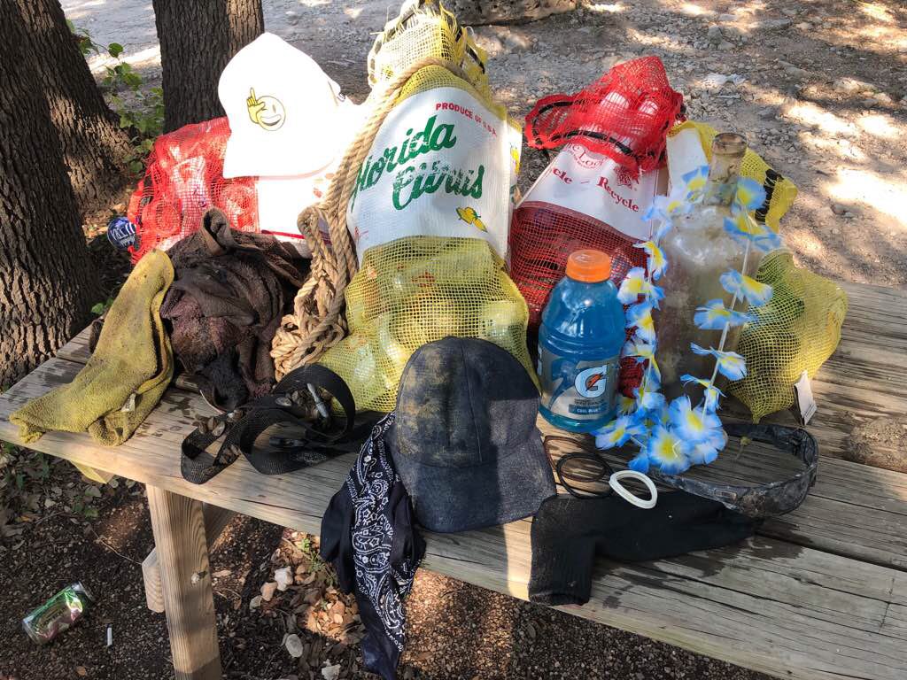
Full bottle of Gatorade
Sunshine
1
2
1
10
1
1
1
1
1
0
0
0
0
0
0
0
0
Strap with plastic clips
Goggles
Party beads
Sunglasses
Ring
Lei
Scrunchy
Quarter
Earring back
Dive World Austin
Todd Fisher
0
0
0
4
1
0
0
0
2
0
0
0
0
0
0
0
0
10
1
2
0
0
0
0
0
0
0
0
0
0
0
0
0
0
15.00
60
60.00
15.00
1
estimated
0
0
3129.57
0
0
0
0
0
Aluminum cans
Rope
Fabric
2
On
pounds
0
I have debris data to report
7
0
0
Calm (glassy to rippled) for waves 0 – 0.1 meter high
0
0
0
0
1
0
0
ft2
0
3
feet
other
0
0
0
0
0
2
0
1
0
2
1
0
0
1
0
0
0
70
0
0
0
0
0
0
0
0
0
0
0
United States
State\Province
Texas
City
Lago Vista
Map Help


Dive Location

If you know your survey site coordinates, enter them manually in decimal degrees using WGS84 Map Datum. Use the minus sign for latitudes south of the equator and longitudes west of the Prime Meridian to 180 degrees.

If you do not know your survey site coordinates, click the “Map Location” tab to use the map to zoom into your survey site and drop the pin on the map to fall within your survey dive site in the water (not on land or the beach). Ensure you zoom in as much as possible to ensure data accuracy.

Entangled Help


Use the vertical tabs below to record any entangled animals you found of each type.

North/Town Pier

22
112
12
8
rock
10
2
473

12.14964104448, -68.277382285075

Cruise Ship pier
Dive Friends Bonaire
50
2
8
8
84
1
5
8
11
2
18
1
200.00
63
18.00
2.00
estimated
66
45.00
11
8
On
kilograms
I have debris data to report
312
Calm (glassy to rippled) for waves 0 – 0.1 meter high
9
1
24
1
m2
13
6
meters
rocky reef
20
8
2
9
8
1
18
3
7
2
5
9
72
46
7
98
Netherlands Antilles
Map Help


Dive Location

If you know your survey site coordinates, enter them manually in decimal degrees using WGS84 Map Datum. Use the minus sign for latitudes south of the equator and longitudes west of the Prime Meridian to 180 degrees.

If you do not know your survey site coordinates, click the “Map Location” tab to use the map to zoom into your survey site and drop the pin on the map to fall within your survey dive site in the water (not on land or the beach). Ensure you zoom in as much as possible to ensure data accuracy.
Entangled Help


Use the vertical tabs below to record any entangled animals you found of each type.

BRIATICO SANT'IRENE (VV) - Località LA BRACE

38.726277777778, 16.022027777778

rock

38.727222, 16.021389

OTTIME
BLUE SUBMARINE by SCUBA WORLD ASD
DOMENICO BARBUTO
22
74.00
45
12.00
5.00
measured
800.00
On
kilograms
I have debris data to report
Calm (glassy to rippled) for waves 0 – 0.1 meter high m2
meters
rocky reef
Italy
State\Province
VIBO VALENTIA
City
MAIERATO - Località Cutà
Map Help


Dive Location

If you know your survey site coordinates, enter them manually in decimal degrees using WGS84 Map Datum. Use the minus sign for latitudes south of the equator and longitudes west of the Prime Meridian to 180 degrees.

If you do not know your survey site coordinates, click the “Map Location” tab to use the map to zoom into your survey site and drop the pin on the map to fall within your survey dive site in the water (not on land or the beach). Ensure you zoom in as much as possible to ensure data accuracy.

Entangled Help


Use the vertical tabs below to record any entangled animals you found of each type.

ADS513 - Horseshoe

26.504645856914, 127.84525929079

coral
Fisherman here often seem to think that sharks are eating their catch and are not particular trying to protect them.
good conditions perfect for diving
Piranha DIvers Okinawa
Jan C. Weirauch
3
0.01
37
22.00
5.00
estimated
1
37.00
On
kilograms
I have debris data to report
Calm (glassy to rippled) for waves 0 – 0.1 meter high
Dead
Grey Reef Shark
1
m2
meters
coral reef
had a hook in his mouth probably starved
Japan
State\Province
Okinawa
City
Onna Village
Map Help


Dive Location

If you know your survey site coordinates, enter them manually in decimal degrees using WGS84 Map Datum. Use the minus sign for latitudes south of the equator and longitudes west of the Prime Meridian to 180 degrees.

If you do not know your survey site coordinates, click the “Map Location” tab to use the map to zoom into your survey site and drop the pin on the map to fall within your survey dive site in the water (not on land or the beach). Ensure you zoom in as much as possible to ensure data accuracy.

Entangled Help


Use the vertical tabs below to record any entangled animals you found of each type.

ADS513 - Horseshoe

26.504645856914, 127.84525929079

coral
20
same as previous times it's not only a divesite but also a popular fishing spot
Conditions where awesome, super flat and perfect for diving.
1
a small bell for fishing
Piranha Divers Okinawa
Jan C. Weirauch
3
1
3.00
210
22.00
5.00
estimated
6
414.22
On
kilograms
I have debris data to report
Calm (glassy to rippled) for waves 0 – 0.1 meter high
4
m2
1
meters
rocky reef
1
1
Japan
State\Province
Okinawa
City
Onna Village
Map Help


Dive Location

If you know your survey site coordinates, enter them manually in decimal degrees using WGS84 Map Datum. Use the minus sign for latitudes south of the equator and longitudes west of the Prime Meridian to 180 degrees.

If you do not know your survey site coordinates, click the “Map Location” tab to use the map to zoom into your survey site and drop the pin on the map to fall within your survey dive site in the water (not on land or the beach). Ensure you zoom in as much as possible to ensure data accuracy.

Entangled Help


Use the vertical tabs below to record any entangled animals you found of each type.

Cuban Freighter

2

25.7044, -80.0884

3
coral
1
18
ghost lobster traps and fishing materials
Moderate
Diver's Paradise
Madeline Kaufman
25
7
153.00
60
30.00
25.00
2
measured
4
6
2500.00
6
2
wood pieces
rope
On
pounds
I have debris data to report
9
Slight for waves 0.5 -1.25 meter high
172
1
ft2
28
2
rope
Soft coral
Injured
feet
coral reef
10
1
1
2
19
1
United States
State\Province
Florida
City
Miami
Map Help


Dive Location

If you know your survey site coordinates, enter them manually in decimal degrees using WGS84 Map Datum. Use the minus sign for latitudes south of the equator and longitudes west of the Prime Meridian to 180 degrees.

If you do not know your survey site coordinates, click the “Map Location” tab to use the map to zoom into your survey site and drop the pin on the map to fall within your survey dive site in the water (not on land or the beach). Ensure you zoom in as much as possible to ensure data accuracy.

Entangled Help


Use the vertical tabs below to record any entangled animals you found of each type.

Emerald Reef

25.677333333333, -80.100466666667

1
coral
3
Moderate
Diver's Paradise
Madeline Kaufman
25
11.00
20
30.00
25.00
2
measured
1
2500.00
On
pounds
I have debris data to report
Slight for waves 0.5 -1.25 meter high ft2
feet
coral reef
United States
State\Province
FL
City
Miami
Map Help


Dive Location

If you know your survey site coordinates, enter them manually in decimal degrees using WGS84 Map Datum. Use the minus sign for latitudes south of the equator and longitudes west of the Prime Meridian to 180 degrees.

If you do not know your survey site coordinates, click the “Map Location” tab to use the map to zoom into your survey site and drop the pin on the map to fall within your survey dive site in the water (not on land or the beach). Ensure you zoom in as much as possible to ensure data accuracy.

Entangled Help


Use the vertical tabs below to record any entangled animals you found of each type.

Seahorse Bay

8
2
3

12.169438227663, 109.3084461954

0
0
0
coral
0
0
0
0
0
Fishing activities
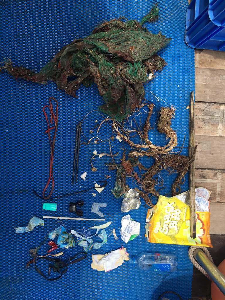
Chopsticks
Cloudy/rainy
1
1
0
0
0
0
0
0
0
0
0
0
0
0
0
0
0
0
0
Plastic chopsticks
Elastic rope
Rainbow Divers
Maisie MacGregor
0
0
0
0
0
0
0
0
1
0
1
0
0
0
0
0
0
0
0
13
0
0
0
0
0
0
0
0
0
0
0
0
0
0
4.00
40
15.00
5.00
2
estimated
0
0
8695.49
0
0
0
1
0
Fishing nets
Fishing lines
Plastic water bottle wrappers
0
On
kilograms
0
I have debris data to report
0
0
0
Smooth (wavelets) for waves 0.1 - 0.5 meter high
1
0
0
0
2
0
0
m2
0
0
meters
coral reef
0
0
0
0
0
0
0
0
0
0
0
0
2
0
0
0
0
0
0
0
0
0
0
0
0
0
0
0
Vietnam
City
Nha Trang
Map Help


Dive Location

If you know your survey site coordinates, enter them manually in decimal degrees using WGS84 Map Datum. Use the minus sign for latitudes south of the equator and longitudes west of the Prime Meridian to 180 degrees.

If you do not know your survey site coordinates, click the “Map Location” tab to use the map to zoom into your survey site and drop the pin on the map to fall within your survey dive site in the water (not on land or the beach). Ensure you zoom in as much as possible to ensure data accuracy.
Entangled Help


Use the vertical tabs below to record any entangled animals you found of each type.

Subscribe to