Menu

Casino Point Dive Park

0
0
0

33.349327282764, -118.32536905422

0
0
0
sand
0
0
0
0
0
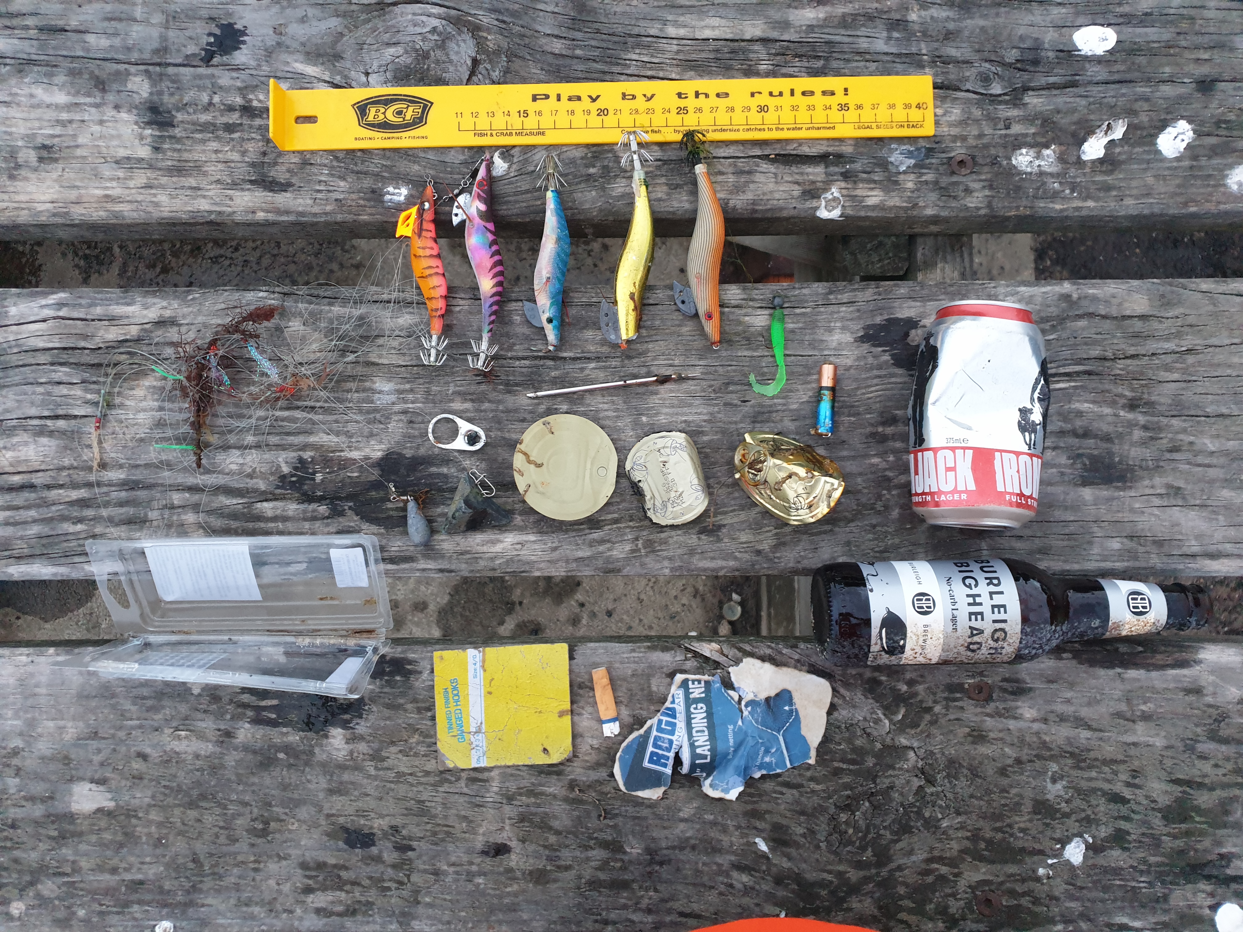
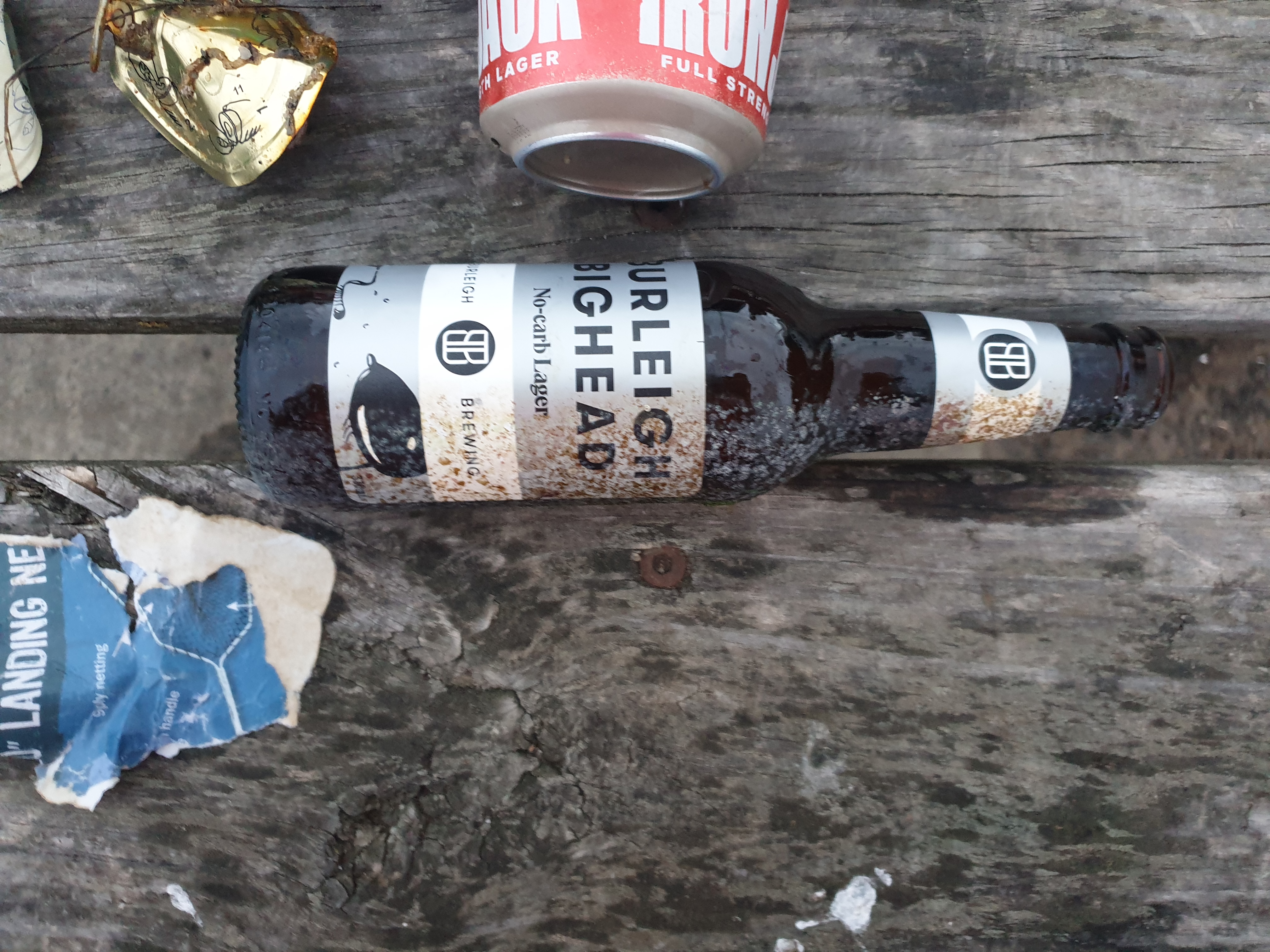
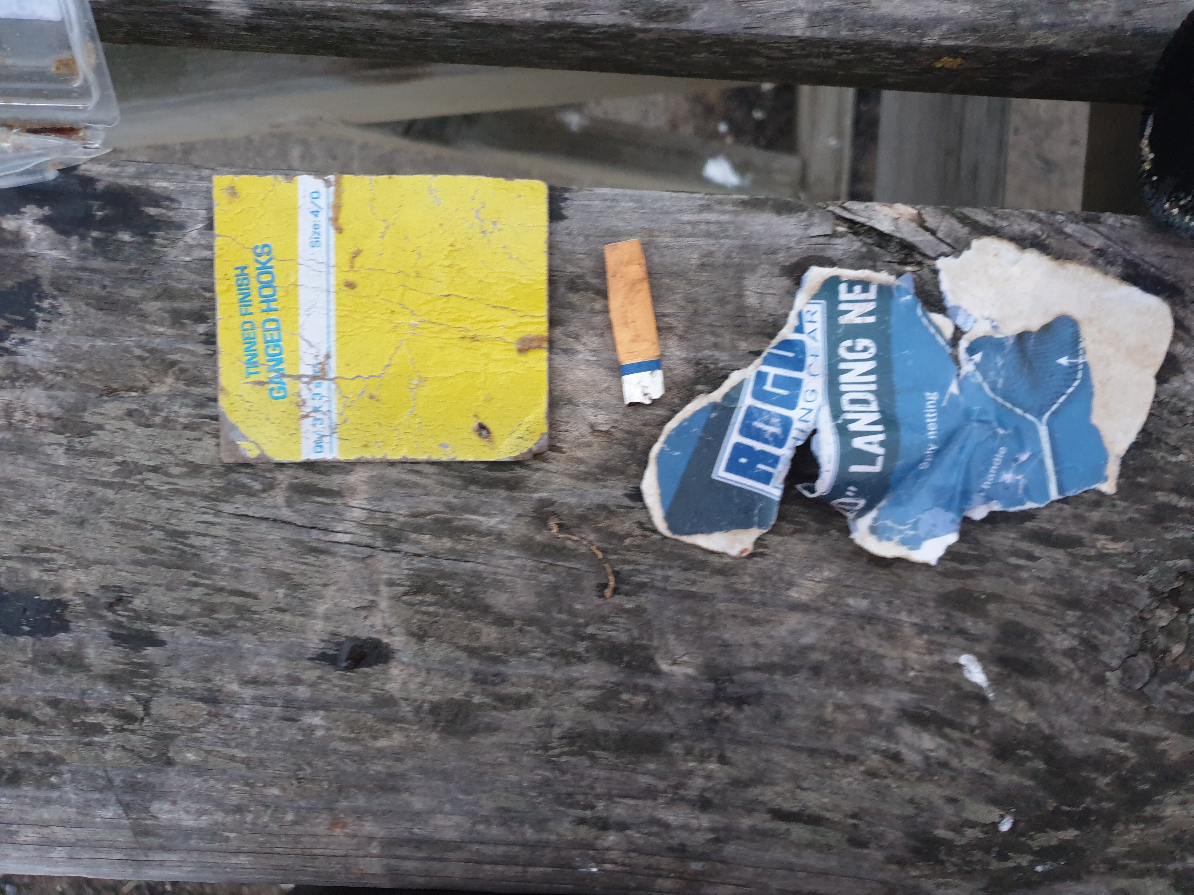
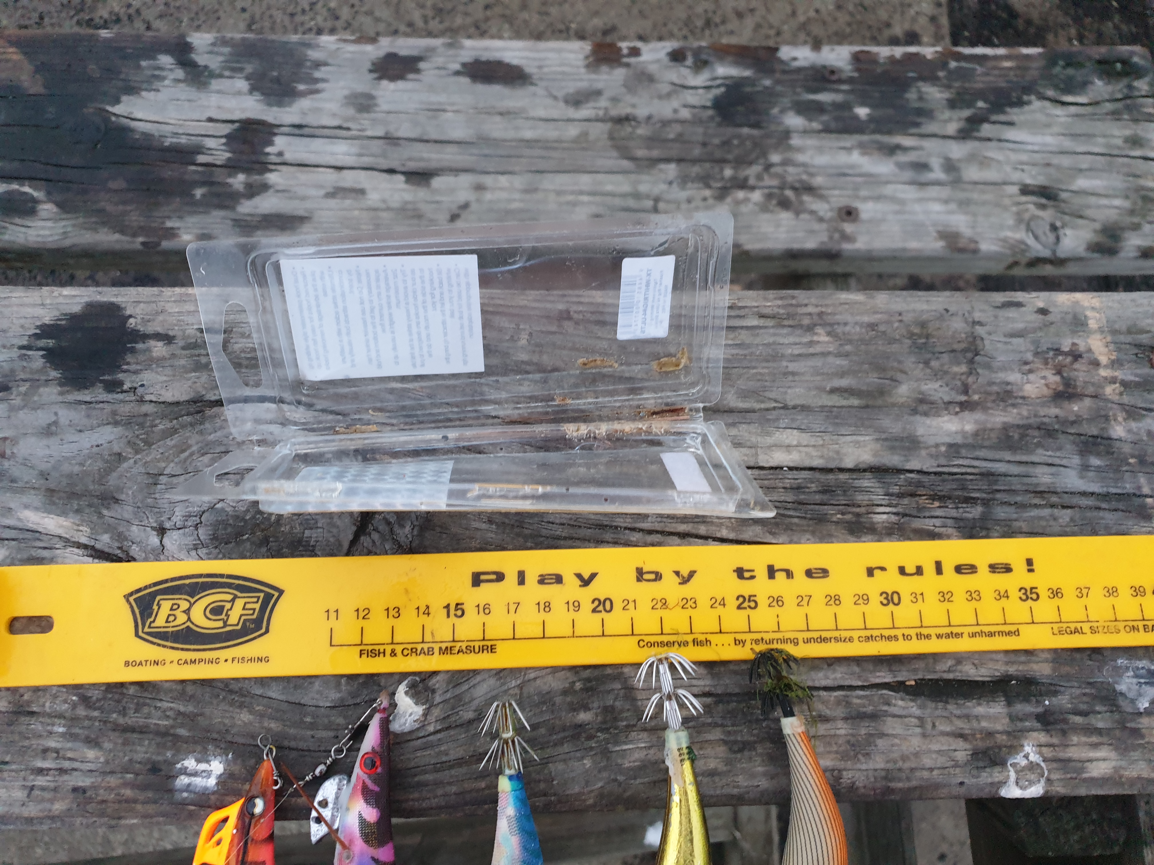
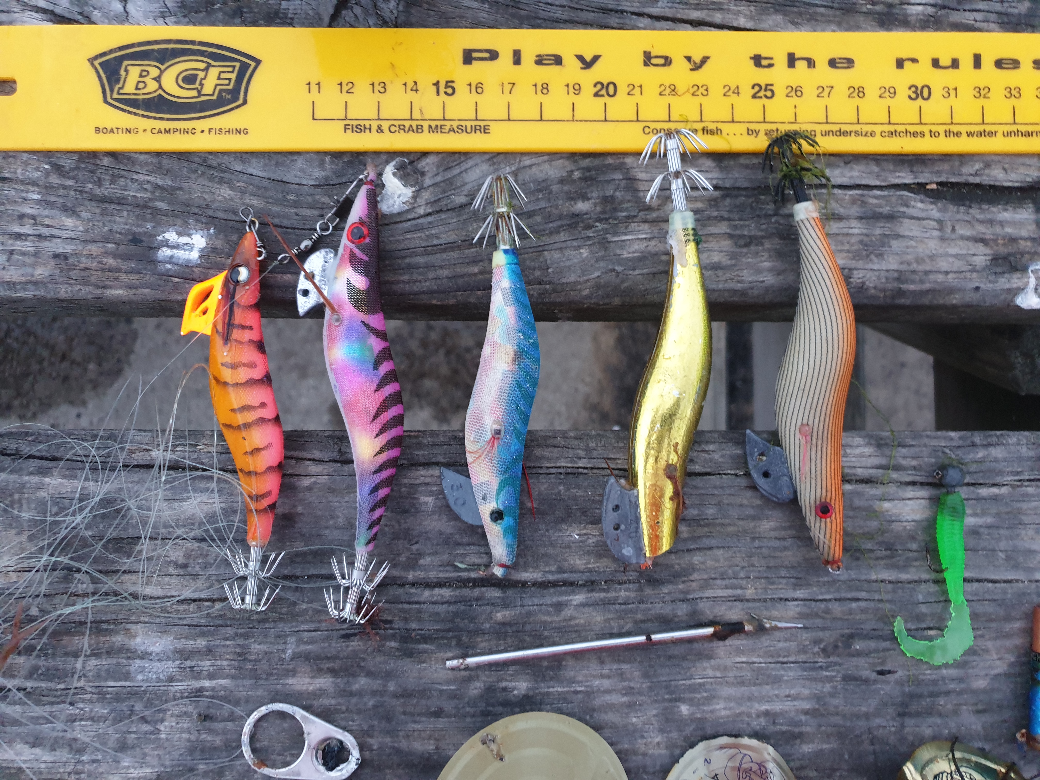
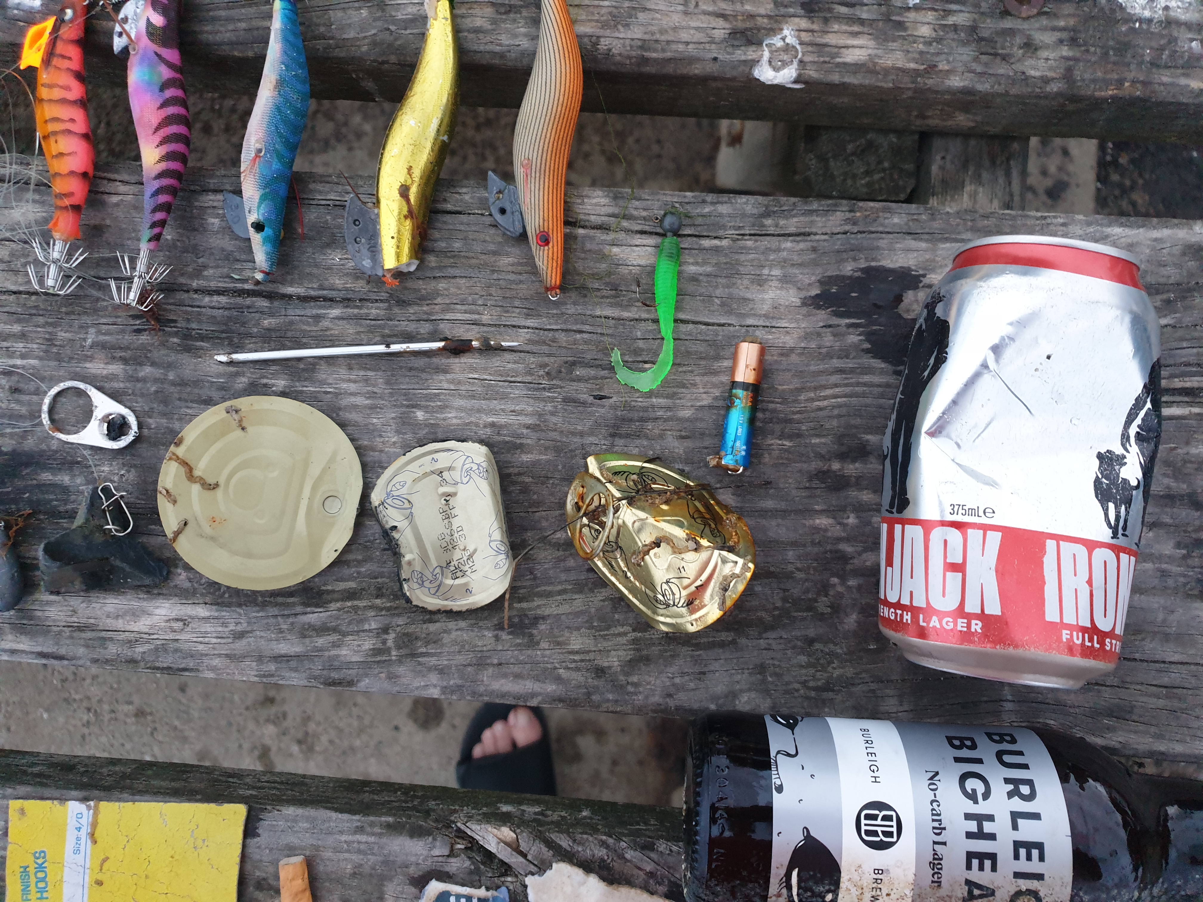
There was a boat that crashed ashore recently and a lot of trash has been drifting through the area lately according to the locals
Second dive if the day, was DMing for a client so trash collecting was not the priority, boat crashed in the area recently lots of trash
Cold and windy
0
0
0
0
0
0
0
0
0
0
0
0
0
0
0
0
0
0
0
0
N/A
Miles Roche
0
0
0
0
0
0
0
0
0
0
0
0
0
0
0
0
0
0
0
2
0
0
0
0
0
0
0
0
0
0
0
0
0
0
0.20
31
86.00
18.00
0
estimated
0
0
6712.24
0
0
0
0
0
0
On
pounds
0
I have debris data to report
0
0
0
Smooth (wavelets) for waves 0.1 - 0.5 meter high
0
0
0
0
0
0
0
ft2
0
0
feet
rocky reef
0
0
0
0
0
0
0
0
0
0
0
0
0
0
0
0
0
0
0
0
0
1
0
0
0
0
0
0
United States
State\Province
CA
City
Avalon
Map Help


Dive Location

If you know your survey site coordinates, enter them manually in decimal degrees using WGS84 Map Datum. Use the minus sign for latitudes south of the equator and longitudes west of the Prime Meridian to 180 degrees.

If you do not know your survey site coordinates, click the “Map Location” tab to use the map to zoom into your survey site and drop the pin on the map to fall within your survey dive site in the water (not on land or the beach). Ensure you zoom in as much as possible to ensure data accuracy.

Entangled Help


Use the vertical tabs below to record any entangled animals you found of each type.

Casino Point Dive Park

0
0
0

33.349103592426, -118.3249086961

0
0
0
sand
0
0
0
0
0
Cold and windy
0
0
0
0
0
0
0
0
0
0
0
0
0
0
0
0
0
0
0
0
N/A
Miles Roche
0
0
0
0
0
0
0
0
0
0
0
0
0
0
0
0
0
0
0
2
0
0
0
0
0
0
0
0
0
0
0
0
0
0
0.00
34
75.00
15.00
0
estimated
0
0
4716.11
0
0
0
0
0
0
On
kilograms
0
Our Survey Site was free of debris
0
0
0
Smooth (wavelets) for waves 0.1 - 0.5 meter high
0
0
0
0
0
0
0
ft2
0
0
feet
rocky reef
0
0
0
0
0
0
0
0
0
0
0
0
0
0
0
0
0
0
0
0
0
0
0
0
0
0
0
0
United States
State\Province
CA
City
Avalon
Map Help


Dive Location

If you know your survey site coordinates, enter them manually in decimal degrees using WGS84 Map Datum. Use the minus sign for latitudes south of the equator and longitudes west of the Prime Meridian to 180 degrees.

If you do not know your survey site coordinates, click the “Map Location” tab to use the map to zoom into your survey site and drop the pin on the map to fall within your survey dive site in the water (not on land or the beach). Ensure you zoom in as much as possible to ensure data accuracy.

Entangled Help


Use the vertical tabs below to record any entangled animals you found of each type.

ADS289 - Balky Point Zeneta

0
0
0
0

37.629910716018, -0.70113191911787

0
0
0
sand
0
3
0
0
0
Hanger
1
Plastic hanger
Balkysub
Asier Cañizares Paton
0
0
0
0
0
0
0
0
0
0
0
0
0
0
0
0
0
0
0
5
0
0
0
0
0
0
0
0
0
0
0
0
0
0
0
0
0.40
65
12.00
3.00
0
estimated
0
0
0
0
625.00
0
0
0
0
0
Plastic
Aluminium cans
Bottles
0
On
kilograms
0
I have debris data to report
0
0
0
Calm (glassy to rippled) for waves 0 – 0.1 meter high
0
0
0
0
0
0
0
m2
0
0
meters
seagrass
0
0
0
0
0
0
0
0
0
0
0
0
0
0
0
0
0
0
0
0
0
0
0
0
0
0
0
0
0
Spain
State\Province
Murcia
City
Cabo de Palos
Map Help


Dive Location

If you know your survey site coordinates, enter them manually in decimal degrees using WGS84 Map Datum. Use the minus sign for latitudes south of the equator and longitudes west of the Prime Meridian to 180 degrees.

If you do not know your survey site coordinates, click the “Map Location” tab to use the map to zoom into your survey site and drop the pin on the map to fall within your survey dive site in the water (not on land or the beach). Ensure you zoom in as much as possible to ensure data accuracy.

Entangled Help


Use the vertical tabs below to record any entangled animals you found of each type.

UMISORA park NAHA

26.2207631, 127.6653204

coral
Honu Honu Divers S-33244
Takahiro Kinjo
2
1
2.00
25
5.00
1.00
estimated
4000.00
On
kilograms
I have debris data to report
Calm (glassy to rippled) for waves 0 – 0.1 meter high m2
meters
coral reef
1
Japan
State\Province
Okinawa
City
Naha
Map Help


Dive Location

If you know your survey site coordinates, enter them manually in decimal degrees using WGS84 Map Datum. Use the minus sign for latitudes south of the equator and longitudes west of the Prime Meridian to 180 degrees.

If you do not know your survey site coordinates, click the “Map Location” tab to use the map to zoom into your survey site and drop the pin on the map to fall within your survey dive site in the water (not on land or the beach). Ensure you zoom in as much as possible to ensure data accuracy.

Entangled Help


Use the vertical tabs below to record any entangled animals you found of each type.

Brighton Old Baths

sand

-37.928357072873, 144.98774786844

1
pest sea star (Northern Pacific Sea Star)
Australian Diving Instruction
Ting Ting Lee
4
3.00
60
5.00
1.00
estimated
1500.00
On
kilograms
I have debris data to report
2
Slight for waves 0.5 -1.25 meter high m2
meters
rocky reef
1
2
0
2
Australia
State\Province
Victoria
City
Geelong
Map Help


Dive Location

If you know your survey site coordinates, enter them manually in decimal degrees using WGS84 Map Datum. Use the minus sign for latitudes south of the equator and longitudes west of the Prime Meridian to 180 degrees.

If you do not know your survey site coordinates, click the “Map Location” tab to use the map to zoom into your survey site and drop the pin on the map to fall within your survey dive site in the water (not on land or the beach). Ensure you zoom in as much as possible to ensure data accuracy.

Entangled Help


Use the vertical tabs below to record any entangled animals you found of each type.

Ecosystem Other
old man-made structure

Sandringham Beach Reef

sand
3

-37.947599914954, 144.99538418025

1
1
ring
tile
Australian Diving Instruction
Ting Ting Lee
10
1
3
3.00
60
5.00
1.00
estimated
14
1500.00
On
kilograms
I have debris data to report
3
Smooth (wavelets) for waves 0.1 - 0.5 meter high m2
meters
rocky reef
Australia
State\Province
Victoria
City
Geelong
Map Help


Dive Location

If you know your survey site coordinates, enter them manually in decimal degrees using WGS84 Map Datum. Use the minus sign for latitudes south of the equator and longitudes west of the Prime Meridian to 180 degrees.

If you do not know your survey site coordinates, click the “Map Location” tab to use the map to zoom into your survey site and drop the pin on the map to fall within your survey dive site in the water (not on land or the beach). Ensure you zoom in as much as possible to ensure data accuracy.

Entangled Help


Use the vertical tabs below to record any entangled animals you found of each type.

20201108_Artsi

2
rock
2
1

36.596608681159, 22.381074641019

Diving Store
Alexandros Vennos
1
1
2
1
18
2.00
20
10.00
5.00
estimated
30.00
On
kilograms
I have debris data to report
Calm (glassy to rippled) for waves 0 – 0.1 meter high m2
meters
rocky reef
Greece
State\Province
Lakonia
City
Lakonia Mani
Map Help


Dive Location

If you know your survey site coordinates, enter them manually in decimal degrees using WGS84 Map Datum. Use the minus sign for latitudes south of the equator and longitudes west of the Prime Meridian to 180 degrees.

If you do not know your survey site coordinates, click the “Map Location” tab to use the map to zoom into your survey site and drop the pin on the map to fall within your survey dive site in the water (not on land or the beach). Ensure you zoom in as much as possible to ensure data accuracy.

Entangled Help


Use the vertical tabs below to record any entangled animals you found of each type.

The Office

0
0
0
0

-23.78372, 35.557602

0
0
0
rock
0
0
0
0
0
Windy
Liquid Dive Adventures
Nadia
0
0
0
0
0
0
0
0
0
0
0
0
0
0
0
0
0
0
0
4
0
0
0
0
0
0
0
0
0
0
0
0
0
0
0
0
0.00
30
24.00
20.00
0
estimated
0
0
0
0
46004.50
0
0
0
0
0
0
On
kilograms
0
Our Survey Site was free of debris
0
0
0
Slight for waves 0.5 -1.25 meter high
0
0
0
0
0
0
0
m2
0
0
meters
rocky reef
0
0
0
0
0
0
0
0
0
0
0
0
0
0
0
0
0
0
0
0
0
0
0
0
0
0
0
0
0
Mozambique
State\Province
Inhambane
City
Tofo
Map Help


Dive Location

If you know your survey site coordinates, enter them manually in decimal degrees using WGS84 Map Datum. Use the minus sign for latitudes south of the equator and longitudes west of the Prime Meridian to 180 degrees.

If you do not know your survey site coordinates, click the “Map Location” tab to use the map to zoom into your survey site and drop the pin on the map to fall within your survey dive site in the water (not on land or the beach). Ensure you zoom in as much as possible to ensure data accuracy.

Entangled Help


Use the vertical tabs below to record any entangled animals you found of each type.

ADS566 - Shell Bay

5
5

22.53333, 114.48333

3
sand
4
Good.
1
Gunstock
Dive4love
Huan Deng
12
8
6
1
1
1
28.90
45
5.00
2.00
measured
2
3000.00
4
On
kilograms
I have debris data to report
11
Slight for waves 0.5 -1.25 meter high
7
1
4
2
m2
5
meters
rocky reef
3
3
1
1
1
1
2
2
China
State\Province
Guangdong
City
Shenzhen
Map Help


Dive Location

If you know your survey site coordinates, enter them manually in decimal degrees using WGS84 Map Datum. Use the minus sign for latitudes south of the equator and longitudes west of the Prime Meridian to 180 degrees.

If you do not know your survey site coordinates, click the “Map Location” tab to use the map to zoom into your survey site and drop the pin on the map to fall within your survey dive site in the water (not on land or the beach). Ensure you zoom in as much as possible to ensure data accuracy.

Entangled Help


Use the vertical tabs below to record any entangled animals you found of each type.

ADS551 - St Leonards Pier

-38.170506361724, 144.71944724921

6
sand
3
Batterie AAA
Fish & Crab Measure (plastic)
Australian Diving Instruction
Jörg Pichler
1
2
3
1
2.00
69
3.30
2.00
estimated
2
500.00
beverage can
fishing line
batterie
On
kilograms
I have debris data to report
1
Calm (glassy to rippled) for waves 0 – 0.1 meter high m2
meters
seagrass
4
1
1
Australia
State\Province
Victoria
City
Geelong
Map Help


Dive Location

If you know your survey site coordinates, enter them manually in decimal degrees using WGS84 Map Datum. Use the minus sign for latitudes south of the equator and longitudes west of the Prime Meridian to 180 degrees.

If you do not know your survey site coordinates, click the “Map Location” tab to use the map to zoom into your survey site and drop the pin on the map to fall within your survey dive site in the water (not on land or the beach). Ensure you zoom in as much as possible to ensure data accuracy.

Entangled Help


Use the vertical tabs below to record any entangled animals you found of each type.

Subscribe to