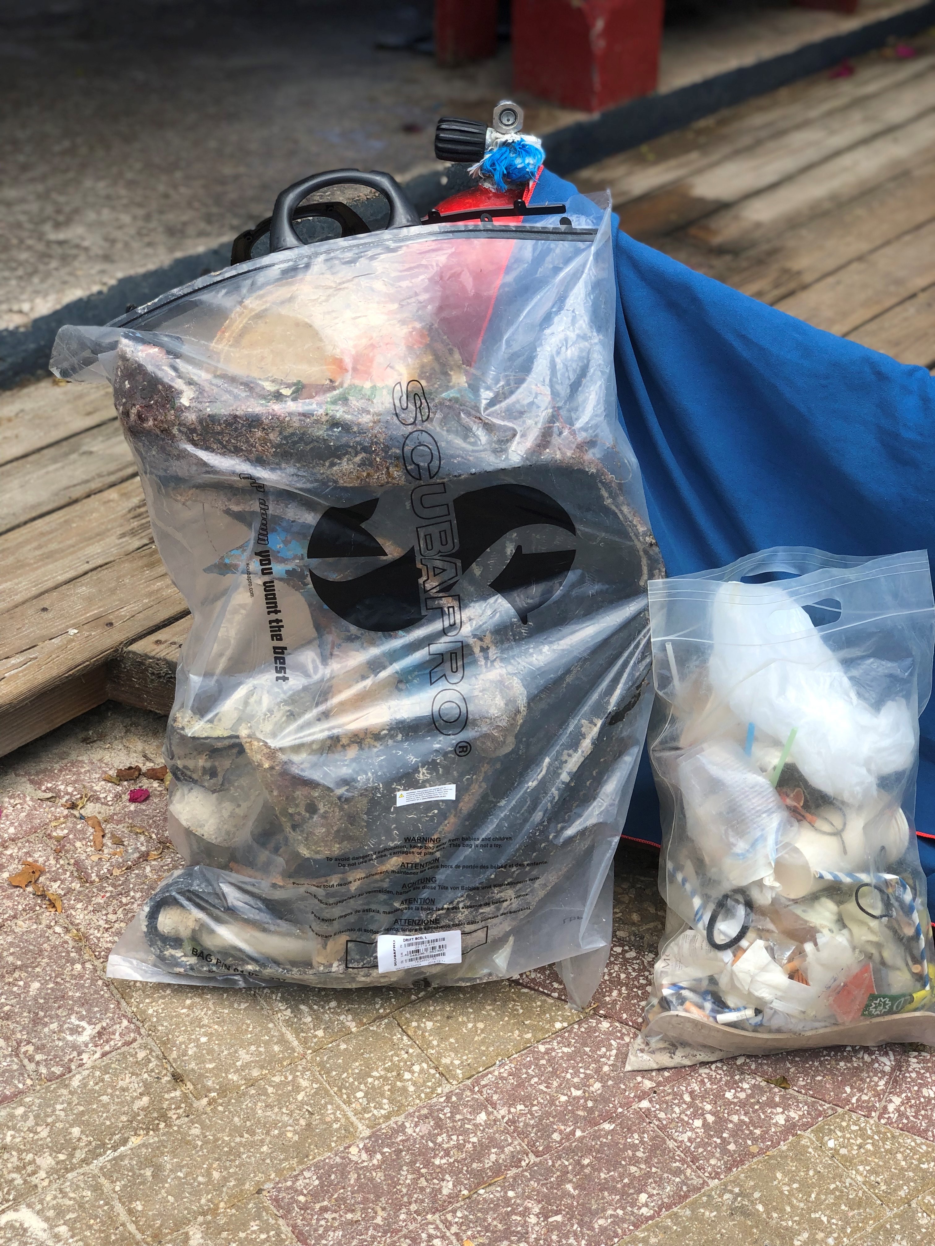
We would like to thank everybody in participating the PADI Aware Week Sept 19-27, 2020. It was a very successful event participated by different nationalities and diving community. Thanks to SQUID, RDA, MacDiver, Knights of Rizal, and individuals who share their passion to save the ocean planet.
Fairly Hot
OFW Community Divers
R Jay R. Dela Cruz
28
8
1
1
21
14
3
3
11
17.00
30
6.00
4.00
estimated
700.00
On
kilograms
I have debris data to report
Calm (glassy to rippled) for waves 0 – 0.1 meter high
m2
1
meters
seagrass
3
2
5
Saudi Arabia
State\Province
Eastern Region
City
Al Khobar
Map Help
Dive Location
If you know your survey site coordinates, enter them manually in decimal degrees using WGS84 Map Datum. Use the minus sign for latitudes south of the equator and longitudes west of the Prime Meridian to 180 degrees.
If you do not know your survey site coordinates, click the “Map Location” tab to use the map to zoom into your survey site and drop the pin on the map to fall within your survey dive site in the water (not on land or the beach). Ensure you zoom in as much as possible to ensure data accuracy.
Entangled Help
Use the vertical tabs below to record any entangled animals you found of each type.
It looks like the bay has improved with less plastic bottles as seen in the past. Also although we collected a small amount of fishing line/net and lures, this is positive as most likely the fisherman are moving away from the reefs in comparison to several months back.
Raining.
Assava Dive Resort
Monique Richards and Natalie Hunt
1
1
1
7
4
3.50
49
12.00
7.00
measured
1
100.00
Fishing lines
On
kilograms
I have debris data to report
8
Smooth (wavelets) for waves 0.1 - 0.5 meter high
2
m2
meters
coral reef
2
2
7
1
Language
English
Thailand
State\Province
Surat Thani
City
Koh Tao
Map Help
Dive Location
If you know your survey site coordinates, enter them manually in decimal degrees using WGS84 Map Datum. Use the minus sign for latitudes south of the equator and longitudes west of the Prime Meridian to 180 degrees.
If you do not know your survey site coordinates, click the “Map Location” tab to use the map to zoom into your survey site and drop the pin on the map to fall within your survey dive site in the water (not on land or the beach). Ensure you zoom in as much as possible to ensure data accuracy.
Entangled Help
Use the vertical tabs below to record any entangled animals you found of each type.
Smooth (wavelets) for waves 0.1 - 0.5 meter high
ft2
feet
rocky reef
1
Language
English
United States
State\Province
FL
City
Pensacola
Map Help
Dive Location
If you know your survey site coordinates, enter them manually in decimal degrees using WGS84 Map Datum. Use the minus sign for latitudes south of the equator and longitudes west of the Prime Meridian to 180 degrees.
If you do not know your survey site coordinates, click the “Map Location” tab to use the map to zoom into your survey site and drop the pin on the map to fall within your survey dive site in the water (not on land or the beach). Ensure you zoom in as much as possible to ensure data accuracy.
Entangled Help
Use the vertical tabs below to record any entangled animals you found of each type.
Calm (glassy to rippled) for waves 0 – 0.1 meter high
ft2
feet
other
7
2
Language
English
Canada
State\Province
British Columbia
City
North Vancouver
Map Help
Dive Location
If you know your survey site coordinates, enter them manually in decimal degrees using WGS84 Map Datum. Use the minus sign for latitudes south of the equator and longitudes west of the Prime Meridian to 180 degrees.
If you do not know your survey site coordinates, click the “Map Location” tab to use the map to zoom into your survey site and drop the pin on the map to fall within your survey dive site in the water (not on land or the beach). Ensure you zoom in as much as possible to ensure data accuracy.
Entangled Help
Use the vertical tabs below to record any entangled animals you found of each type.
A cart wheel - we did not remove due to limited gear we brought
Sunny and windy
1
Umbrella
Four Seasons Maldives
Angela
1
2
5
1
9.00
44
24.90
5.00
7
estimated
2
120.00
On
kilograms
I have debris data to report
8
Smooth (wavelets) for waves 0.1 - 0.5 meter high
m2
meters
coral reef
1
1
1
1
Language
English
Maldives
State\Province
Baa Atoll
City
Landaa Giraavaru
Map Help
Dive Location
If you know your survey site coordinates, enter them manually in decimal degrees using WGS84 Map Datum. Use the minus sign for latitudes south of the equator and longitudes west of the Prime Meridian to 180 degrees.
If you do not know your survey site coordinates, click the “Map Location” tab to use the map to zoom into your survey site and drop the pin on the map to fall within your survey dive site in the water (not on land or the beach). Ensure you zoom in as much as possible to ensure data accuracy.
Entangled Help
Use the vertical tabs below to record any entangled animals you found of each type.
Calm (glassy to rippled) for waves 0 – 0.1 meter high
1
1
m2
meters
rocky reef
1
1
1
3
1
1
1
3
Language
English
Maldives
State\Province
Baa Atoll
City
Landaa Giraavaru
Map Help
Dive Location
If you know your survey site coordinates, enter them manually in decimal degrees using WGS84 Map Datum. Use the minus sign for latitudes south of the equator and longitudes west of the Prime Meridian to 180 degrees.
If you do not know your survey site coordinates, click the “Map Location” tab to use the map to zoom into your survey site and drop the pin on the map to fall within your survey dive site in the water (not on land or the beach). Ensure you zoom in as much as possible to ensure data accuracy.
Entangled Help
Use the vertical tabs below to record any entangled animals you found of each type.
Calm (glassy to rippled) for waves 0 – 0.1 meter high
ft2
5
feet
coral reef
75
7
Language
English
United States
Map Help
Dive Location
If you know your survey site coordinates, enter them manually in decimal degrees using WGS84 Map Datum. Use the minus sign for latitudes south of the equator and longitudes west of the Prime Meridian to 180 degrees.
If you do not know your survey site coordinates, click the “Map Location” tab to use the map to zoom into your survey site and drop the pin on the map to fall within your survey dive site in the water (not on land or the beach). Ensure you zoom in as much as possible to ensure data accuracy.
Entangled Help
Use the vertical tabs below to record any entangled animals you found of each type.
Calm (glassy to rippled) for waves 0 – 0.1 meter high
m2
meters
coral reef
1
3
Language
English
Netherlands Antilles
Map Help
Dive Location
If you know your survey site coordinates, enter them manually in decimal degrees using WGS84 Map Datum. Use the minus sign for latitudes south of the equator and longitudes west of the Prime Meridian to 180 degrees.
If you do not know your survey site coordinates, click the “Map Location” tab to use the map to zoom into your survey site and drop the pin on the map to fall within your survey dive site in the water (not on land or the beach). Ensure you zoom in as much as possible to ensure data accuracy.
Entangled Help
Use the vertical tabs below to record any entangled animals you found of each type.
Calm, and flat. Very little wind, a little bit of light rain
1
3
2
25
6
10
1
1
Shopping Trolley
Sunglasses
Hair Clip
Wet Wipes
Hair Bands
Q-tips
Razor
Nos Canister
Diving with Nic
Nic
4
8
10
3
1
9
4
1
2
2
90.00
120
6.00
1.00
measured
25
1000.00
1
10
Wetwipes due to the poor state of the local plumbing
On
kilograms
I have debris data to report
Calm (glassy to rippled) for waves 0 – 0.1 meter high
1
1
12
m2
4
3
meters
rocky reef
1
10
2
15
5
Language
English
Spain
State\Province
Malaga
City
Fuengirola
Map Help
Dive Location
If you know your survey site coordinates, enter them manually in decimal degrees using WGS84 Map Datum. Use the minus sign for latitudes south of the equator and longitudes west of the Prime Meridian to 180 degrees.
If you do not know your survey site coordinates, click the “Map Location” tab to use the map to zoom into your survey site and drop the pin on the map to fall within your survey dive site in the water (not on land or the beach). Ensure you zoom in as much as possible to ensure data accuracy.
Entangled Help
Use the vertical tabs below to record any entangled animals you found of each type.