Menu

LaBuga #383465

1

9.3374, -82.240211

sand
5

9.3374657, -82.2405709

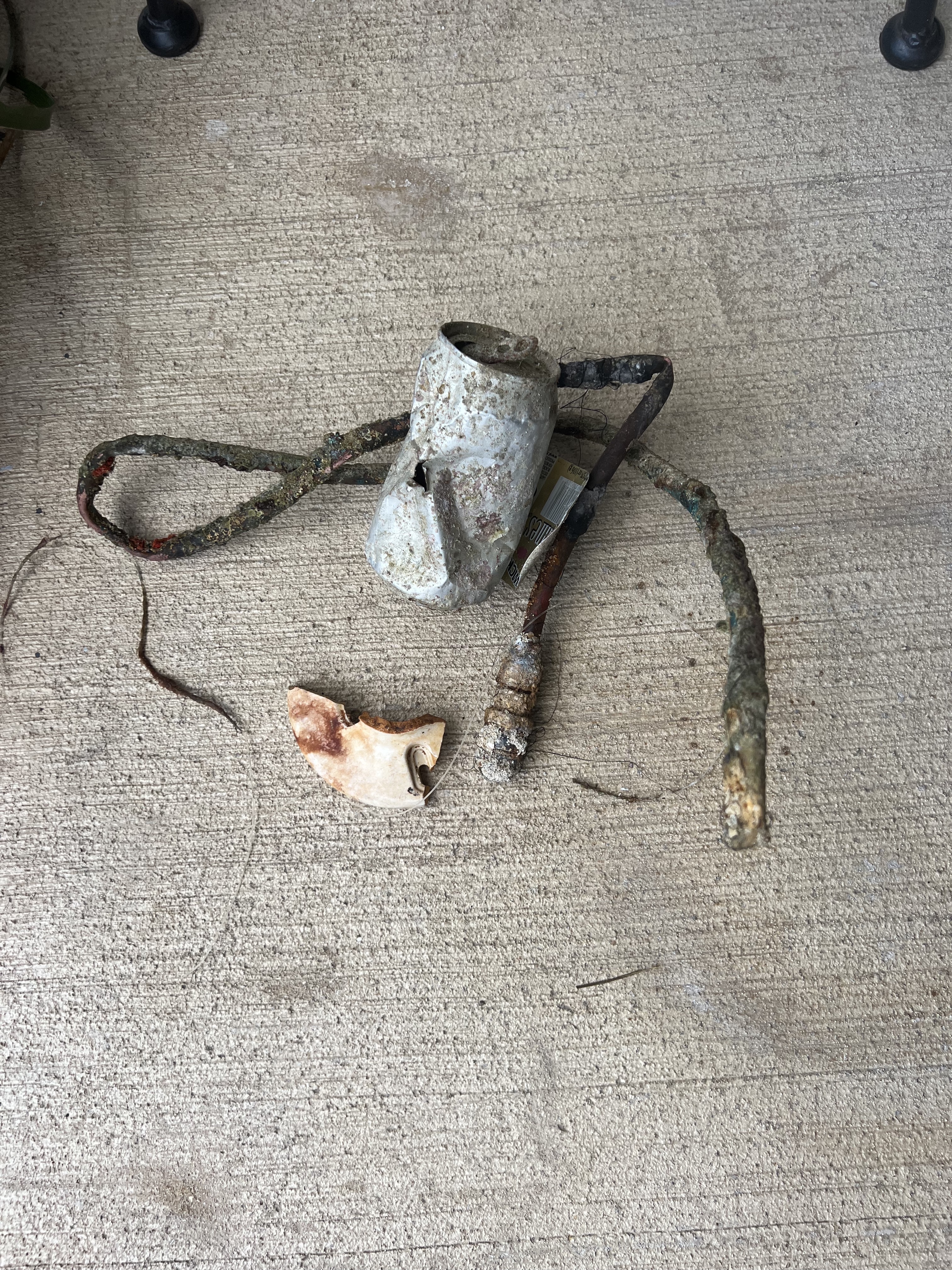
There are some discoteques where we found a lot of cans and beer bottles. We already spoke with the owners to raise awareness among their costumers about dropping things in the water.
They said they will put signlas and more trash cans.
No
Nothing special
No rain, flat sea, no waves, good visibility
La Buga
Ruben Oscar Estrada
1
6
2
66
15
5
1
40.00
60
6.00
3.00
measured
2100.00
Beer bottles
Beer cans
Plastic bottles
On
kilograms
I have debris data to report
37
Calm (glassy to rippled) for waves 0 – 0.1 meter high
5
m2
meters
other
1
4
63
4
9
1
Panama
State\Province
Bocas del Toro
City
Isla Colon
Map Help


Dive Location

If you know your survey site coordinates, enter them manually in decimal degrees using WGS84 Map Datum. Use the minus sign for latitudes south of the equator and longitudes west of the Prime Meridian to 180 degrees.

If you do not know your survey site coordinates, click the “Map Location” tab to use the map to zoom into your survey site and drop the pin on the map to fall within your survey dive site in the water (not on land or the beach). Ensure you zoom in as much as possible to ensure data accuracy.

Entangled Help


Use the vertical tabs below to record any entangled animals you found of each type.

Ecosystem Other
Sandy bottom

ADS594 - Nestends Gully

0
0
0
0

55.875456, -2.081563

0
0
0
rock
0
0
0
0
0
The Fifth Point
Matthew Stephenson
0
0
0
0
0
0
0
0
0
0
0
0
0
0
0
0
0
0
0
6
0
0
1
0
0
0
0
0
0
0
0
0
2
0
0
0
0.50
29
14.20
4.00
0
estimated
0
0
0
0
315.64
1
0
0
0
0
0
On
kilograms
0
I have debris data to report
0
0
0
Smooth (wavelets) for waves 0.1 - 0.5 meter high
0
0
0
0
0
0
0
m2
0
0
meters
rocky reef
0
0
0
0
0
0
0
0
0
0
0
0
0
0
0
0
0
1
0
0
0
0
0
0
0
0
0
0
0
United Kingdom
State\Province
Berwick
City
Eyemouth
Map Help


Dive Location

If you know your survey site coordinates, enter them manually in decimal degrees using WGS84 Map Datum. Use the minus sign for latitudes south of the equator and longitudes west of the Prime Meridian to 180 degrees.

If you do not know your survey site coordinates, click the “Map Location” tab to use the map to zoom into your survey site and drop the pin on the map to fall within your survey dive site in the water (not on land or the beach). Ensure you zoom in as much as possible to ensure data accuracy.

Entangled Help


Use the vertical tabs below to record any entangled animals you found of each type.

ADS592 - Lady Hole

0
0
0
0

55.553049, -1.624422

0
0
0
rock
0
0
0
0
0
The Fifth Point
Matt Stephenson
0
0
0
0
0
0
0
0
0
0
0
0
0
0
0
0
0
0
0
6
0
0
0
0
0
0
0
0
0
0
0
0
0
0
0
0
0.00
32
6.00
2.00
0
estimated
0
0
0
0
1534.90
0
0
0
0
0
0
On
pounds
0
Our Survey Site was free of debris
0
0
0
Smooth (wavelets) for waves 0.1 - 0.5 meter high
0
0
0
0
0
0
0
m2
0
0
meters
rocky reef
0
0
0
0
0
0
0
0
0
0
0
0
0
0
0
0
0
0
0
0
0
0
0
0
0
0
0
0
0
United Kingdom
State\Province
Northumberland
City
Beadnell
Map Help


Dive Location

If you know your survey site coordinates, enter them manually in decimal degrees using WGS84 Map Datum. Use the minus sign for latitudes south of the equator and longitudes west of the Prime Meridian to 180 degrees.

If you do not know your survey site coordinates, click the “Map Location” tab to use the map to zoom into your survey site and drop the pin on the map to fall within your survey dive site in the water (not on land or the beach). Ensure you zoom in as much as possible to ensure data accuracy.

Entangled Help


Use the vertical tabs below to record any entangled animals you found of each type.

Big Harcar

0
0
0
0

55.638657, -1.622405

0
0
0
rock
0
0
0
0
0
The Fifth Point Diving Centre
Nic Emery
0
0
0
0
0
0
0
0
0
0
0
0
0
0
0
0
0
0
0
10
0
0
0
0
0
0
0
0
0
0
0
0
0
0
0
0
0.00
34
9.00
1.00
0
estimated
0
0
0
0
1164.03
0
0
0
0
0
0
On
pounds
0
Our Survey Site was free of debris
0
0
0
Smooth (wavelets) for waves 0.1 - 0.5 meter high
0
0
0
0
0
0
0
m2
0
0
meters
kelp
0
0
0
0
0
0
0
0
0
0
0
0
0
0
0
0
0
0
0
0
0
0
0
0
0
0
0
0
0
United Kingdom
State\Province
Northumberland
City
Seahouses
Map Help


Dive Location

If you know your survey site coordinates, enter them manually in decimal degrees using WGS84 Map Datum. Use the minus sign for latitudes south of the equator and longitudes west of the Prime Meridian to 180 degrees.

If you do not know your survey site coordinates, click the “Map Location” tab to use the map to zoom into your survey site and drop the pin on the map to fall within your survey dive site in the water (not on land or the beach). Ensure you zoom in as much as possible to ensure data accuracy.

Entangled Help


Use the vertical tabs below to record any entangled animals you found of each type.

Northern Hares

0
0
0
0

55.646576, -1.614089

0
0
0
rock
0
0
0
0
0
The Fifth Point
Nic Emery
0
0
0
0
0
0
0
0
0
0
0
0
0
0
0
0
0
0
0
11
0
0
0
0
0
0
0
0
0
0
0
0
0
0
0
0
0.00
30
24.00
12.00
0
estimated
0
0
0
0
793.92
0
0
0
0
0
0
On
pounds
0
Our Survey Site was free of debris
0
0
0
Smooth (wavelets) for waves 0.1 - 0.5 meter high
0
0
0
0
0
0
0
m2
0
0
meters
rocky reef
0
0
0
0
0
0
0
0
0
0
0
0
0
0
0
0
0
0
0
0
0
0
0
0
0
0
0
0
0
United Kingdom
State\Province
Northumberland
City
Seahouses
Map Help


Dive Location

If you know your survey site coordinates, enter them manually in decimal degrees using WGS84 Map Datum. Use the minus sign for latitudes south of the equator and longitudes west of the Prime Meridian to 180 degrees.

If you do not know your survey site coordinates, click the “Map Location” tab to use the map to zoom into your survey site and drop the pin on the map to fall within your survey dive site in the water (not on land or the beach). Ensure you zoom in as much as possible to ensure data accuracy.

Entangled Help


Use the vertical tabs below to record any entangled animals you found of each type.

Blue Planet House Reef

1
coral
5

-5.6099126921591, 120.44877335119

Current, some rain
Indo Ocean Project
Benjamin Graves
6
0.10
19
8.00
4.00
measured
500.00
fishing line
plastic wrappers
Can
On
kilograms
I have debris data to report
Slight for waves 0.5 -1.25 meter high m2
4
meters
coral reef
1
Indonesia
State\Province
Bulukumba
City
Bira
Map Help


Dive Location

If you know your survey site coordinates, enter them manually in decimal degrees using WGS84 Map Datum. Use the minus sign for latitudes south of the equator and longitudes west of the Prime Meridian to 180 degrees.

If you do not know your survey site coordinates, click the “Map Location” tab to use the map to zoom into your survey site and drop the pin on the map to fall within your survey dive site in the water (not on land or the beach). Ensure you zoom in as much as possible to ensure data accuracy.

Entangled Help


Use the vertical tabs below to record any entangled animals you found of each type.

Hin Ngam

1
38
5
3
sand
62

10.068254679921, 99.840959248056

horn, airpod
one slug, several corals entangled in nets, ropes on the reef
Cloud, choppy
1
1
airpod
horn
The Coral Tribe
Jennifer Dowling
1
11
6.50
59
10.10
4.80
measured
350.00
fishing line
rope
plastic fragments
1
On
kilograms
I have debris data to report
Smooth (wavelets) for waves 0.1 - 0.5 meter high
net
crab
Released Unharmed
1
1
3
m2
23
1
plastic
sea slug, coral
Injured
meters
coral reef
1
1
Thailand
State\Province
Surat Thani
City
Koh Tao
Map Help


Dive Location

If you know your survey site coordinates, enter them manually in decimal degrees using WGS84 Map Datum. Use the minus sign for latitudes south of the equator and longitudes west of the Prime Meridian to 180 degrees.

If you do not know your survey site coordinates, click the “Map Location” tab to use the map to zoom into your survey site and drop the pin on the map to fall within your survey dive site in the water (not on land or the beach). Ensure you zoom in as much as possible to ensure data accuracy.

Entangled Help


Use the vertical tabs below to record any entangled animals you found of each type.

Aow Leuk

2
13
2
sand
1
1
50

10.072023809018, 99.839932374656

1 shrimp 3 crab
syringe
Cloudy, choppy
2
zip ties
The Coral Tribe
Jenny Dowling
1
1
1
11
3
1
3.50
57
12.70
6.00
measured
500.00
fishing line
plastic fragment
rope
On
kilograms
I have debris data to report
Smooth (wavelets) for waves 0.1 - 0.5 meter high
plastic
shrimp, crab
Injured
4
m2
6
4
plastic
worm
Injured
meters
coral reef
2
Thailand
State\Province
Surat Thani
City
Koh Tao
Map Help


Dive Location

If you know your survey site coordinates, enter them manually in decimal degrees using WGS84 Map Datum. Use the minus sign for latitudes south of the equator and longitudes west of the Prime Meridian to 180 degrees.

If you do not know your survey site coordinates, click the “Map Location” tab to use the map to zoom into your survey site and drop the pin on the map to fall within your survey dive site in the water (not on land or the beach). Ensure you zoom in as much as possible to ensure data accuracy.

Entangled Help


Use the vertical tabs below to record any entangled animals you found of each type.

Rodadero

0
0
0
0

4.653951, -74.081584

0
0
0
rock
2
7
0
0
0
Beautiful place
No
Nice
Na
Dead
Bag
Hot
5
Tornilo
Padi Santamarta
Oscar
0
0
0
0
0
0
0
0
0
0
0
0
0
0
0
0
0
0
0
3
4
0
0
0
0
0
0
0
0
0
0
0
0
0
0
0
3.00
47
36.00
34.00
0
measured
0
0
0
0
409794.00
0
0
0
0
0
Bags
Na
0
On
kilograms
0
I have debris data to report
0
0
0
Slight for waves 0.5 -1.25 meter high
0
0
0
n/a
Animal
1
Dead
Shark
1
Golero
0
0
0
0
ft2
0
0
Dead
meters
kelp
2
0
0
0
0
0
0
0
0
0
5
14
3
0
0
0
0
0
0
0
0
0
Na
Injured
Turtoise
0
0
0
0
0
0
0
0
Colombia
State\Province
Magdalena
City
Santamarta
Map Help


Dive Location

If you know your survey site coordinates, enter them manually in decimal degrees using WGS84 Map Datum. Use the minus sign for latitudes south of the equator and longitudes west of the Prime Meridian to 180 degrees.

If you do not know your survey site coordinates, click the “Map Location” tab to use the map to zoom into your survey site and drop the pin on the map to fall within your survey dive site in the water (not on land or the beach). Ensure you zoom in as much as possible to ensure data accuracy.

Entangled Help


Use the vertical tabs below to record any entangled animals you found of each type.

Anthony Bell

25.0943, -77.34222

1
coral
1
Calm, sunny and warm
Albany Marine Academy
Richard Carr
4
1.00
50
50.00
36.00
estimated
199.00
On
kilograms
I have debris data to report
Smooth (wavelets) for waves 0.1 - 0.5 meter high m2
feet
coral reef
1
2
Bahamas
State\Province
New Providence
City
Nassau
Map Help


Dive Location

If you know your survey site coordinates, enter them manually in decimal degrees using WGS84 Map Datum. Use the minus sign for latitudes south of the equator and longitudes west of the Prime Meridian to 180 degrees.

If you do not know your survey site coordinates, click the “Map Location” tab to use the map to zoom into your survey site and drop the pin on the map to fall within your survey dive site in the water (not on land or the beach). Ensure you zoom in as much as possible to ensure data accuracy.

Entangled Help


Use the vertical tabs below to record any entangled animals you found of each type.

Subscribe to