Menu

Sharp Island

sand

22.362502016533, 114.29072947089

Global Aqua
Anthony Lau
1
3
0.48
35
7.00
5.00
measured
50.00
On
kilograms
I have debris data to report
Smooth (wavelets) for waves 0.1 - 0.5 meter high
1
m2
meters
coral reef
1
Hong Kong S.A.R., China
Map Help


Dive Location

If you know your survey site coordinates, enter them manually in decimal degrees using WGS84 Map Datum. Use the minus sign for latitudes south of the equator and longitudes west of the Prime Meridian to 180 degrees.

If you do not know your survey site coordinates, click the “Map Location” tab to use the map to zoom into your survey site and drop the pin on the map to fall within your survey dive site in the water (not on land or the beach). Ensure you zoom in as much as possible to ensure data accuracy.

Entangled Help


Use the vertical tabs below to record any entangled animals you found of each type.

Seacrest Park Cove 2

0
1
0
0

47.589229057521, -122.37907615926

0
0
0
silt
0
0
0
0
0
Busy dive site
Ferry traffic
NA
Overcast
Seattle Dive Tours
Liam Ward
0
0
0
0
0
0
0
0
0
0
0
0
0
0
0
0
0
0
0
3
0
0
0
0
0
0
0
0
0
0
0
0
0
0
0
0
0.01
17
60.00
10.00
0
estimated
0
0
0
0
7148.03
0
0
0
0
0
Shipping containers
Ferry litter
Fishing gear
0
On
pounds
0
I have debris data to report
0
0
0
Calm (glassy to rippled) for waves 0 – 0.1 meter high
0
0
0
0
0
0
0
ft2
0
0
feet
rocky reef
0
0
0
0
0
0
0
0
0
0
0
0
0
0
0
0
0
0
0
0
0
0
0
0
0
0
0
0
0
United States
State\Province
Washington
City
Seattle
Map Help


Dive Location

If you know your survey site coordinates, enter them manually in decimal degrees using WGS84 Map Datum. Use the minus sign for latitudes south of the equator and longitudes west of the Prime Meridian to 180 degrees.

If you do not know your survey site coordinates, click the “Map Location” tab to use the map to zoom into your survey site and drop the pin on the map to fall within your survey dive site in the water (not on land or the beach). Ensure you zoom in as much as possible to ensure data accuracy.
Entangled Help


Use the vertical tabs below to record any entangled animals you found of each type.

South Brohard Park

0
2
0
0

27.065618354004, -82.449854428668

0
0
0
sand
0
0
0
0
0
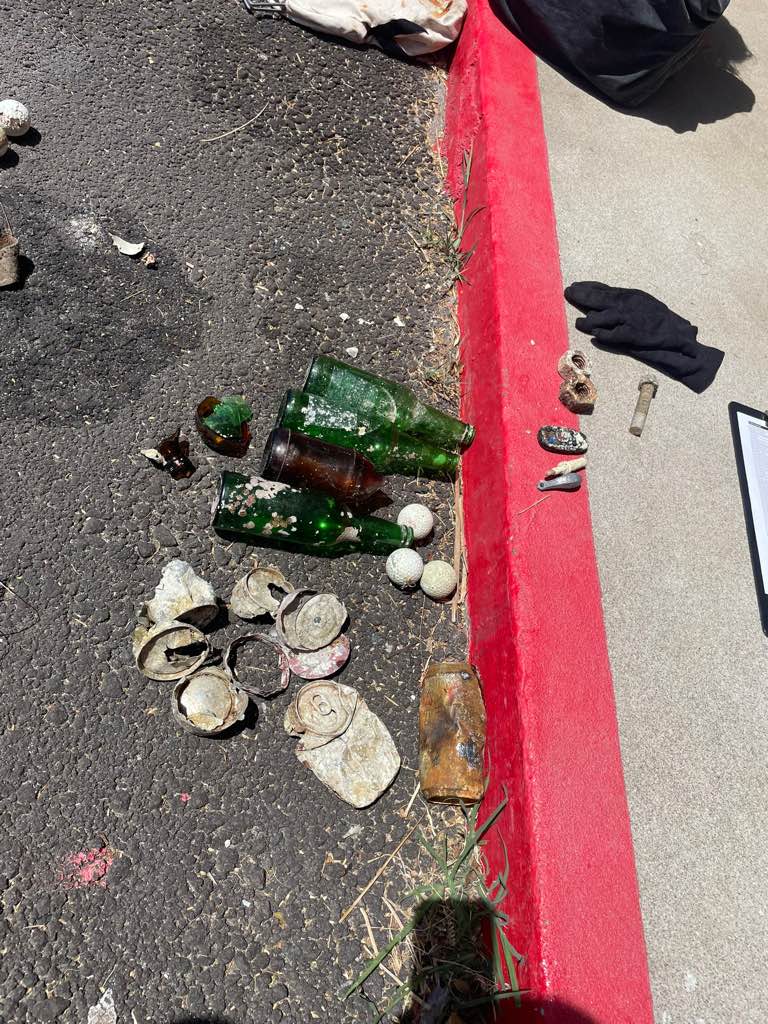
Visibility was one foot, so not much was found
No
The plastic cap is not pictured, as it was being used to release some crabs that were brought in on the trash at the time of the photo
White plastic piece
Some rain past few days
1
Trap fragment (wood, metal, and plastic)
Sarasota Ocean Preservers
Brooke Welch
0
0
0
0
0
0
0
0
1
0
0
0
0
0
0
0
0
1
0
1
0
0
0
0
0
0
0
0
0
0
0
0
0
0
0
0
0.10
30
15.00
13.00
0
estimated
0
0
429.74
0
0
0
0
0
Derelict traps
Plastic fragments
Cans
0
On
pounds
0
I have debris data to report
0
0
0
Slight for waves 0.5 -1.25 meter high
0
0
0
0
0
0
0
m2
0
0
feet
other
0
0
0
0
0
1
0
0
0
0
0
0
0
0
0
0
0
2
0
0
0
0
0
0
0
0
0
0
0
United States
State\Province
Florida
City
Venice
Map Help


Dive Location

If you know your survey site coordinates, enter them manually in decimal degrees using WGS84 Map Datum. Use the minus sign for latitudes south of the equator and longitudes west of the Prime Meridian to 180 degrees.

If you do not know your survey site coordinates, click the “Map Location” tab to use the map to zoom into your survey site and drop the pin on the map to fall within your survey dive site in the water (not on land or the beach). Ensure you zoom in as much as possible to ensure data accuracy.

Entangled Help


Use the vertical tabs below to record any entangled animals you found of each type.

Ecosystem Other
Artificial reef

Zurrieq

0
1
0
0

35.819455916422, 14.451133582504

0
0
0
rock
0
1
0
1
0

35.819455916422, 14.451133582504

Bottles
Sunny
Techwise
Michael Tandy
0
0
0
0
0
0
0
0
0
0
0
0
0
0
0
0
0
0
0
4
0
0
0
0
0
0
0
0
0
0
0
0
0
0
0
0
0.50
42
28.00
7.00
0
estimated
0
0
20.41
0
0
0
0
0
0
On
kilograms
0
I have debris data to report
2
0
0
Slight for waves 0.5 -1.25 meter high
0
0
0
0
0
0
0
m2
0
0
meters
rocky reef
0
0
0
0
0
0
0
0
0
0
0
0
0
0
0
0
0
0
0
0
0
0
0
0
0
0
0
0
0
Malta
State\Province
Malta
City
Zurrie
Map Help


Dive Location

If you know your survey site coordinates, enter them manually in decimal degrees using WGS84 Map Datum. Use the minus sign for latitudes south of the equator and longitudes west of the Prime Meridian to 180 degrees.

If you do not know your survey site coordinates, click the “Map Location” tab to use the map to zoom into your survey site and drop the pin on the map to fall within your survey dive site in the water (not on land or the beach). Ensure you zoom in as much as possible to ensure data accuracy.

Entangled Help


Use the vertical tabs below to record any entangled animals you found of each type.

Tala Bay

1
2
0
0

29.407567150036, 34.976521863644

0
0
0
seagrass
0
2
0
3
0
Windy
Deep Blue Dive Center
Catherine Hoelzer
0
0
0
0
0
0
0
0
0
0
0
0
0
0
0
0
0
0
0
2
0
0
0
0
0
0
0
0
0
0
0
0
0
0
0
0
0.25
60
15.00
5.00
0
estimated
0
3
1180.81
0
0
0
0
0
0
On
kilograms
0
I have debris data to report
0
0
0
Calm (glassy to rippled) for waves 0 – 0.1 meter high
0
0
0
0
0
0
0
m2
0
0
meters
coral reef
0
0
0
0
0
0
0
0
0
0
0
0
0
0
0
0
0
1
0
0
0
0
0
0
0
0
0
0
0
Jordan
State\Province
Aqaba
City
Aqaba
Map Help


Dive Location

If you know your survey site coordinates, enter them manually in decimal degrees using WGS84 Map Datum. Use the minus sign for latitudes south of the equator and longitudes west of the Prime Meridian to 180 degrees.

If you do not know your survey site coordinates, click the “Map Location” tab to use the map to zoom into your survey site and drop the pin on the map to fall within your survey dive site in the water (not on land or the beach). Ensure you zoom in as much as possible to ensure data accuracy.

Entangled Help


Use the vertical tabs below to record any entangled animals you found of each type.

Snapper Ledge

sand
1

24.990427500921, -80.4114010499

none
Windy
Rainbow Reef Dive Center
Mustufa Harianawala
7
0.50
32
30.00
18.00
estimated
4
10000.00
fishing line
On
pounds
I have debris data to report
Slight for waves 0.5 -1.25 meter high ft2
feet
coral reef
United States
State\Province
FL
City
Key Largo
Map Help


Dive Location

If you know your survey site coordinates, enter them manually in decimal degrees using WGS84 Map Datum. Use the minus sign for latitudes south of the equator and longitudes west of the Prime Meridian to 180 degrees.

If you do not know your survey site coordinates, click the “Map Location” tab to use the map to zoom into your survey site and drop the pin on the map to fall within your survey dive site in the water (not on land or the beach). Ensure you zoom in as much as possible to ensure data accuracy.

Entangled Help


Use the vertical tabs below to record any entangled animals you found of each type.

Black Turtle Reef

50
97
2
sand

10.085390729129, 99.824001418024

Close to the pier, hotspot for trash
Remote control
Monsoon: heavy rain + no wind
1
Anchor
Black Turtle Dive
Lucas Levy
1
7
2
1
7
5
1
24.00
30
4.00
1.00
2
measured
3
1000.00
Plastic
Glass
Wood
1
On
kilograms
I have debris data to report
25
Calm (glassy to rippled) for waves 0 – 0.1 meter high
18
1
1
2
1
m2
meters
coral reef
3
1
1
3
5
1
Thailand
State\Province
ST
City
Koh Tao
Map Help


Dive Location

If you know your survey site coordinates, enter them manually in decimal degrees using WGS84 Map Datum. Use the minus sign for latitudes south of the equator and longitudes west of the Prime Meridian to 180 degrees.

If you do not know your survey site coordinates, click the “Map Location” tab to use the map to zoom into your survey site and drop the pin on the map to fall within your survey dive site in the water (not on land or the beach). Ensure you zoom in as much as possible to ensure data accuracy.

Entangled Help


Use the vertical tabs below to record any entangled animals you found of each type.

Coki Beach

0
0
0
0

18.326322218939, -64.83622254397

0
0
0
rock
0
0
0
1
0
Clear
None
Tim
0
0
0
0
0
0
0
0
0
0
0
0
0
0
0
0
0
1
0
2
0
0
0
0
1
0
0
0
0
0
0
0
0
0
0
0
4.00
70
60.00
10.00
0
estimated
0
0
55693.60
0
0
0
0
0
Fishing Line
0
On
pounds
0
I have debris data to report
1
0
0
Calm (glassy to rippled) for waves 0 – 0.1 meter high
0
0
0
0
0
0
0
ft2
0
0
feet
coral reef
0
0
0
0
0
0
0
0
0
0
0
0
0
0
0
0
0
1
0
0
0
0
0
0
0
0
0
0
0
U.S. Virgin Islands
City
St Thomas
Map Help


Dive Location

If you know your survey site coordinates, enter them manually in decimal degrees using WGS84 Map Datum. Use the minus sign for latitudes south of the equator and longitudes west of the Prime Meridian to 180 degrees.

If you do not know your survey site coordinates, click the “Map Location” tab to use the map to zoom into your survey site and drop the pin on the map to fall within your survey dive site in the water (not on land or the beach). Ensure you zoom in as much as possible to ensure data accuracy.

Entangled Help


Use the vertical tabs below to record any entangled animals you found of each type.

Fulidhoo lagoon

50
1

3, 73

1
sand
5
1
20
Moderate weather
Fulidhoo dive and water sports
Andrea Eva Blum
1
2
1
5
2
75.00
60
5.00
1.00
10
estimated
43.00
1
6
Fishing line
Plastic
Ropes
On
kilograms
I have debris data to report
2
2
Calm (glassy to rippled) for waves 0 – 0.1 meter high
4
5
5
8
ft2
meters
other
7
1
2
1
1
15
4
50
1
1
Maldives
Map Help


Dive Location

If you know your survey site coordinates, enter them manually in decimal degrees using WGS84 Map Datum. Use the minus sign for latitudes south of the equator and longitudes west of the Prime Meridian to 180 degrees.

If you do not know your survey site coordinates, click the “Map Location” tab to use the map to zoom into your survey site and drop the pin on the map to fall within your survey dive site in the water (not on land or the beach). Ensure you zoom in as much as possible to ensure data accuracy.

Entangled Help


Use the vertical tabs below to record any entangled animals you found of each type.

Ecosystem Other
Lagoon

Junkyard

7
20
1
sand
4
18
4

10.086869384103, 99.819425576823

1 Dead Crab
Weight Belt
Rain
1
1
Mouthpiece of Regulator
Scuba Weightbelt
The Coral Tribe
Jennifer Dowling
1
1
3
1
10
1
4
2.40
44
15.40
8.00
estimated
1
3000.00
1
1
Plastic Fragment
Fishing Line
Food Wrappers
On
kilograms
I have debris data to report
Smooth (wavelets) for waves 0.1 - 0.5 meter high
Fishing Line
Released Unharmed
small fish
Crabs
Released Unharmed
14
2
Fishing Line
2
m2
5
1
meters
coral reef
1
4
1
1
Thailand
State\Province
Surat Thani
City
Koh Tao
Map Help


Dive Location

If you know your survey site coordinates, enter them manually in decimal degrees using WGS84 Map Datum. Use the minus sign for latitudes south of the equator and longitudes west of the Prime Meridian to 180 degrees.

If you do not know your survey site coordinates, click the “Map Location” tab to use the map to zoom into your survey site and drop the pin on the map to fall within your survey dive site in the water (not on land or the beach). Ensure you zoom in as much as possible to ensure data accuracy.

Entangled Help


Use the vertical tabs below to record any entangled animals you found of each type.

Subscribe to