Menu

A Hole

24.828117, -80.64495

coral
Key Dives
Morgan Gardner
1
9
14.00
45
80.00
35.00
measured
1
1
1000.00
On
pounds
I have debris data to report
Slight for waves 0.5 -1.25 meter high ft2
1
feet
coral reef
1
United States
State\Province
FL
City
Islamorada
Map Help


Dive Location

If you know your survey site coordinates, enter them manually in decimal degrees using WGS84 Map Datum. Use the minus sign for latitudes south of the equator and longitudes west of the Prime Meridian to 180 degrees.

If you do not know your survey site coordinates, click the “Map Location” tab to use the map to zoom into your survey site and drop the pin on the map to fall within your survey dive site in the water (not on land or the beach). Ensure you zoom in as much as possible to ensure data accuracy.

Entangled Help


Use the vertical tabs below to record any entangled animals you found of each type.

Long Point

0
1
0
0

33.406623381678, -118.36682772521

0
0
0
sand
0
0
0
0
0
Bleu World
Kayla
0
0
0
0
0
0
0
0
0
0
0
0
0
0
0
0
0
0
0
7
0
0
0
0
0
0
0
0
0
0
0
0
1
0
0
0
4.50
36
13.90
7.20
0
estimated
0
0
1179.36
0
0
0
0
0
0
On
pounds
0
I have debris data to report
1
1
0
Calm (glassy to rippled) for waves 0 – 0.1 meter high
0
0
0
0
0
0
0
m2
0
0
meters
rocky reef
0
0
0
0
0
0
0
0
0
0
0
0
0
0
0
0
0
0
0
0
0
0
0
0
0
0
0
0
0
United States
City
Avalon
Map Help


Dive Location

If you know your survey site coordinates, enter them manually in decimal degrees using WGS84 Map Datum. Use the minus sign for latitudes south of the equator and longitudes west of the Prime Meridian to 180 degrees.

If you do not know your survey site coordinates, click the “Map Location” tab to use the map to zoom into your survey site and drop the pin on the map to fall within your survey dive site in the water (not on land or the beach). Ensure you zoom in as much as possible to ensure data accuracy.
Entangled Help


Use the vertical tabs below to record any entangled animals you found of each type.

West Quarry

0
0
0
0

33.442987923897, -118.46977435538

0
0
0
rock
0
0
0
0
0
1
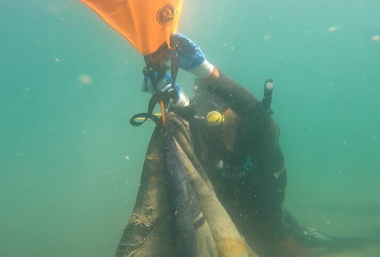
SMB + reel
Bleu World
Kayla
0
0
0
0
0
0
0
0
0
0
0
0
0
0
0
0
0
0
0
7
0
0
0
0
0
0
0
0
0
0
0
0
0
0
0
0
6.00
34
20.50
11.30
0
estimated
0
0
1167.88
0
0
0
0
0
0
On
pounds
0
I have debris data to report
0
0
0
Calm (glassy to rippled) for waves 0 – 0.1 meter high
0
0
0
0
0
0
0
m2
0
0
meters
kelp
0
0
0
0
0
0
0
0
0
0
0
0
0
0
0
0
0
1
0
0
0
0
0
0
0
0
0
0
0
United States
City
Avalon
Map Help


Dive Location

If you know your survey site coordinates, enter them manually in decimal degrees using WGS84 Map Datum. Use the minus sign for latitudes south of the equator and longitudes west of the Prime Meridian to 180 degrees.

If you do not know your survey site coordinates, click the “Map Location” tab to use the map to zoom into your survey site and drop the pin on the map to fall within your survey dive site in the water (not on land or the beach). Ensure you zoom in as much as possible to ensure data accuracy.
Entangled Help


Use the vertical tabs below to record any entangled animals you found of each type.

Red Lava Wall

0
0
0
0

33.424692221379, -118.41464325553

0
0
0
sand
0
0
0
0
0
Bleu World
Kayla
0
0
0
0
0
0
0
0
0
0
0
0
0
0
0
0
0
0
0
7
0
0
0
0
0
0
0
0
0
0
0
0
0
0
0
0
0.00
36
5.30
3.80
0
measured
0
0
8016.03
0
0
0
0
0
0
On
kilograms
0
Our Survey Site was free of debris
0
0
0
Smooth (wavelets) for waves 0.1 - 0.5 meter high
0
0
0
0
0
0
0
m2
0
0
meters
rocky reef
0
0
0
0
0
0
0
0
0
0
0
0
0
0
0
0
0
0
0
0
0
0
0
0
0
0
0
0
0
United States
City
Avalon
Map Help


Dive Location

If you know your survey site coordinates, enter them manually in decimal degrees using WGS84 Map Datum. Use the minus sign for latitudes south of the equator and longitudes west of the Prime Meridian to 180 degrees.

If you do not know your survey site coordinates, click the “Map Location” tab to use the map to zoom into your survey site and drop the pin on the map to fall within your survey dive site in the water (not on land or the beach). Ensure you zoom in as much as possible to ensure data accuracy.

Entangled Help


Use the vertical tabs below to record any entangled animals you found of each type.

Plic Tenki

0
0
0
3

45.072696, 14.723122

1
0
0
rock
0
0
0
8
0
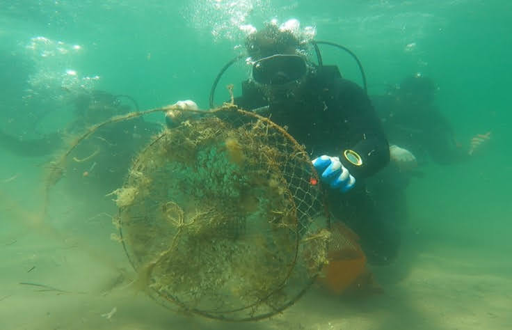
This site is unique as it is one of the few places where there is still large Gorgonia sea fans. The fishing nets and Lines get intangible in the fans and it's a delicate removal.
Winter storms
Most of the fishing line picked up was old with Marine growth. The fragments of fishing net were new from this year with no growth on it. Every year for the last three years we have heard of or removed personally two discarded gillnets on average. We could see more discarded or lost fishing lines below us going deeper than our limit.
New fishing net fragments
Onshore wind
Diving Centre Mihuric
Jelly Gelletich
0
0
0
0
0
0
0
0
0
0
0
0
0
0
0
0
0
0
0
3
0
0
0
0
0
0
0
0
0
0
0
0
0
0
0
0
0.90
53
18.80
3.00
1
measured
0
0
0
0
1892.52
0
0
0
0
0
Discarded fishing line
Discarded fishing nets
0
On
kilograms
0
I have debris data to report
0
0
0
Calm (glassy to rippled) for waves 0 – 0.1 meter high
0
0
0
0
0
0
0
m2
0
0
meters
rocky reef
0
0
0
0
0
0
0
0
0
0
0
0
0
0
0
0
0
0
0
0
0
0
0
0
0
0
0
0
0
Croatia
Map Help


Dive Location

If you know your survey site coordinates, enter them manually in decimal degrees using WGS84 Map Datum. Use the minus sign for latitudes south of the equator and longitudes west of the Prime Meridian to 180 degrees.

If you do not know your survey site coordinates, click the “Map Location” tab to use the map to zoom into your survey site and drop the pin on the map to fall within your survey dive site in the water (not on land or the beach). Ensure you zoom in as much as possible to ensure data accuracy.

Entangled Help


Use the vertical tabs below to record any entangled animals you found of each type.

305991 Magic Island

2
24
3
37
9
sand
11
2
122
3

21.282519026217, -157.84534453639

When is Jack coming to visit? 😎
Ala Wai runoff
Earth Day cleanup at Magic Island with Aqua Lung, PADI, Nudi Wear.
Sunny and warm
12
11
1
1
1
1
1
Vape pens
Pillows
Suitcase
Walkie talkie
Chain (50 feet)
5 gallon tool Caddy
CD's (1 was Brittney Spears❤️)
Multiple, PADI, Aqua Lung, Nudi Wear
Ryan Scalf
2
1
3
12
2
12
3
3
7
52
3
6
3
5
5
54
32
1
5
3
1
1
1928.00
50
35.00
4.00
6
measured
1
432
400.00
12
14
2
3
On
pounds
I have debris data to report
84
2
2
Calm (glassy to rippled) for waves 0 – 0.1 meter high
5
13
3
34
6
5
ft2
1
10
feet
coral reef
6
16
3
26
6
1
3
2
4
9
24
10
56
6
3
4
8
United States
State\Province
HI
City
Honolulu
Map Help


Dive Location

If you know your survey site coordinates, enter them manually in decimal degrees using WGS84 Map Datum. Use the minus sign for latitudes south of the equator and longitudes west of the Prime Meridian to 180 degrees.

If you do not know your survey site coordinates, click the “Map Location” tab to use the map to zoom into your survey site and drop the pin on the map to fall within your survey dive site in the water (not on land or the beach). Ensure you zoom in as much as possible to ensure data accuracy.

Entangled Help


Use the vertical tabs below to record any entangled animals you found of each type.

Tokong Burung

0
0
0
16

5.9616851, 102.6779541

0
0
0
coral
0
0
0
0
0
SEA VOICE DIVERS
Amir
0
0
0
0
0
0
0
0
0
0
0
0
0
0
0
0
0
0
0
12
0
0
0
0
0
0
0
0
0
0
0
0
0
0
0
0
7.88
60
10.00
8.00
0
measured
0
0
1170.08
0
0
0
0
0
0
On
kilograms
0
I have debris data to report
0
0
0
Calm (glassy to rippled) for waves 0 – 0.1 meter high
0
0
0
0
0
0
0
m2
0
0
meters
coral reef
0
0
0
0
0
0
0
0
0
0
0
0
0
0
0
0
0
0
0
0
0
0
0
0
0
0
0
0
0
Malaysia
State\Province
Terengganu
City
Perhentian Island
Map Help


Dive Location

If you know your survey site coordinates, enter them manually in decimal degrees using WGS84 Map Datum. Use the minus sign for latitudes south of the equator and longitudes west of the Prime Meridian to 180 degrees.

If you do not know your survey site coordinates, click the “Map Location” tab to use the map to zoom into your survey site and drop the pin on the map to fall within your survey dive site in the water (not on land or the beach). Ensure you zoom in as much as possible to ensure data accuracy.

Entangled Help


Use the vertical tabs below to record any entangled animals you found of each type.

Snake Cave Phi Phi

0
0
0
0

7.718790809373, 98.76691356851

0
0
0
silt
0
0
0
0
0
Calm
Dr Maurizio Carmini
0
0
0
0
0
0
0
0
0
0
0
0
0
0
0
0
0
0
0
2
0
0
0
0
0
0
0
0
0
0
0
0
0
0
0
0
0.00
90
20.20
1.00
0
measured
0
0
100.00
0
0
0
0
0
0
On
kilograms
0
Our Survey Site was free of debris
0
0
0
Calm (glassy to rippled) for waves 0 – 0.1 meter high
0
0
0
0
0
0
0
m2
0
0
meters
other
0
0
0
0
0
0
0
0
0
0
0
0
0
0
0
0
0
0
0
0
0
0
0
0
0
0
0
0
0
Thailand
State\Province
Krabi
City
Koh Phi Phi Don
Map Help


Dive Location

If you know your survey site coordinates, enter them manually in decimal degrees using WGS84 Map Datum. Use the minus sign for latitudes south of the equator and longitudes west of the Prime Meridian to 180 degrees.

If you do not know your survey site coordinates, click the “Map Location” tab to use the map to zoom into your survey site and drop the pin on the map to fall within your survey dive site in the water (not on land or the beach). Ensure you zoom in as much as possible to ensure data accuracy.

Entangled Help


Use the vertical tabs below to record any entangled animals you found of each type.

Ecosystem Other
Cave environment

Crystal Bay House Reef

-1
17
2
2
coral
8

-8.715747084181, 115.45767077259

some sort of screw for a boat
Indo Ocean Project
Anne van den Boomen
1
1
4
1.35
52
9.50
0.00
2
measured
100.00
On
kilograms
I have debris data to report
Slight for waves 0.5 -1.25 meter high m2
meters
coral reef
1
Indonesia
City
Nusa Penida
Map Help


Dive Location

If you know your survey site coordinates, enter them manually in decimal degrees using WGS84 Map Datum. Use the minus sign for latitudes south of the equator and longitudes west of the Prime Meridian to 180 degrees.

If you do not know your survey site coordinates, click the “Map Location” tab to use the map to zoom into your survey site and drop the pin on the map to fall within your survey dive site in the water (not on land or the beach). Ensure you zoom in as much as possible to ensure data accuracy.

Entangled Help


Use the vertical tabs below to record any entangled animals you found of each type.

The Maze

0
0
0
0

24.922893926988, -80.578751120489

0
0
0
coral
0
0
0
0
0
No
Scuba Shack
William Mitlehner
0
0
0
0
0
0
0
0
0
0
0
0
0
0
0
0
0
0
0
3
0
0
0
0
1
0
0
0
0
0
0
0
0
0
0
0
0.50
45
30.00
20.00
0
estimated
0
0
350.24
0
0
0
0
0
Plastic
0
On
pounds
0
I have debris data to report
0
0
0
Smooth (wavelets) for waves 0.1 - 0.5 meter high
0
0
0
0
0
0
0
ft2
0
0
feet
coral reef
0
0
0
0
0
0
0
0
0
0
0
0
0
0
0
0
0
0
0
0
0
0
0
0
0
0
0
0
0
United States
State\Province
FL
City
Islamorada
Map Help


Dive Location

If you know your survey site coordinates, enter them manually in decimal degrees using WGS84 Map Datum. Use the minus sign for latitudes south of the equator and longitudes west of the Prime Meridian to 180 degrees.

If you do not know your survey site coordinates, click the “Map Location” tab to use the map to zoom into your survey site and drop the pin on the map to fall within your survey dive site in the water (not on land or the beach). Ensure you zoom in as much as possible to ensure data accuracy.

Entangled Help


Use the vertical tabs below to record any entangled animals you found of each type.

Subscribe to