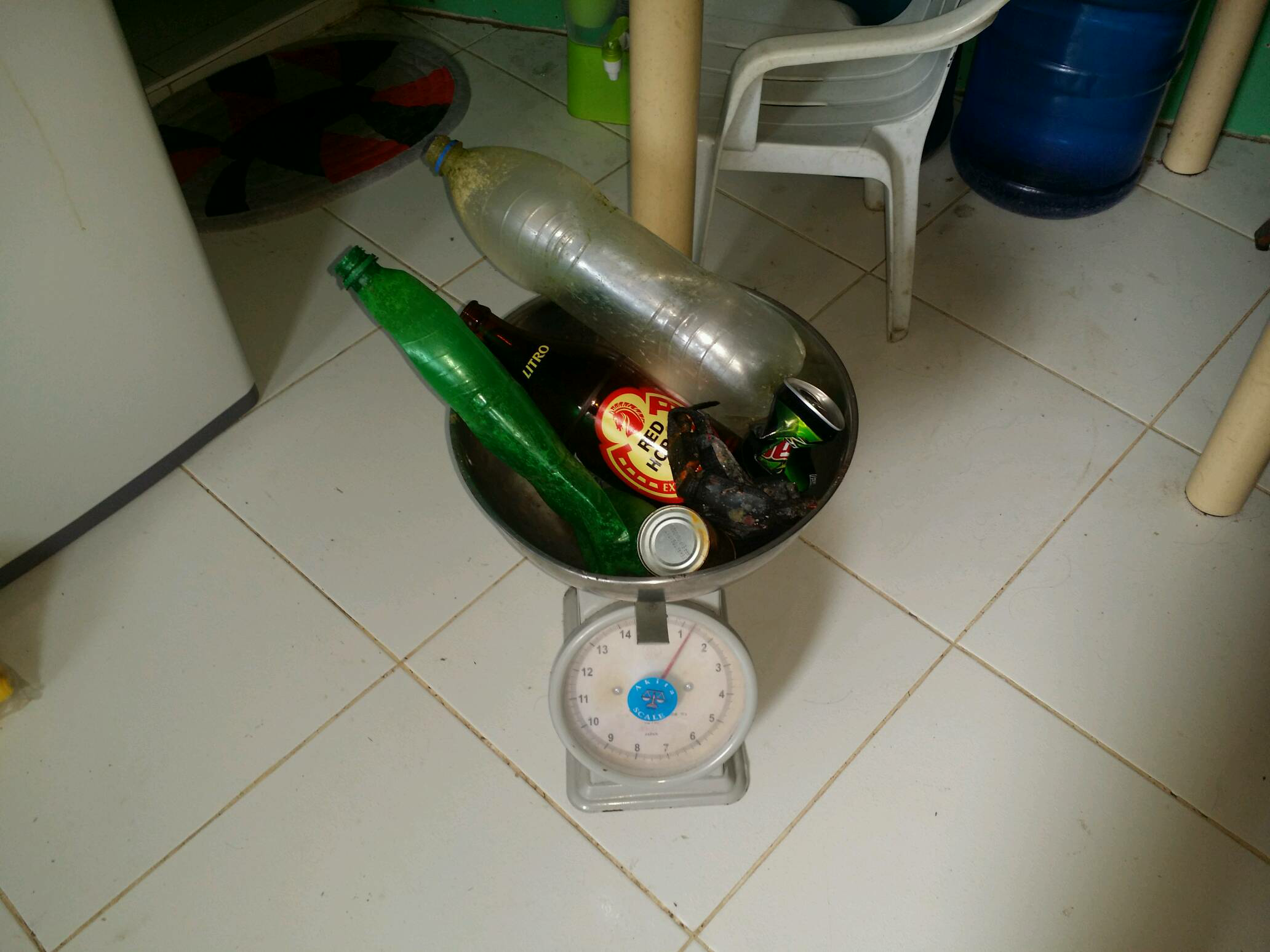
Strap & buckle, perhaps from a BCD or other scuba gear
sunny
Scotty's Action Sports Network
Jampa
0
0
0
0
0
0
0
0
0
0
0
0
0
0
0
0
0
0
0
2
0
0
0
0
0
0
0
0
0
2
0
0
0
0
0
0
1.25
35
21.00
5.00
0
measured
0
0
0
0
5491.45
0
0
0
0
0
Plastic bottles
Glass bottle
Small pieces of plastic
0
On
kilograms
0
I have debris data to report
1
0
0
Moderate to rough for waves greater than 1.25 meters
0
0
0
0
0
0
0
m2
0
0
meters
coral reef
0
0
0
0
0
0
0
0
0
1
0
0
0
0
0
0
1
1
0
0
0
0
0
0
0
0
0
0
0
Philippines
State\Province
Cebu
City
Lapu-Lapu City
Map Help
Dive Location
If you know your survey site coordinates, enter them manually in decimal degrees using WGS84 Map Datum. Use the minus sign for latitudes south of the equator and longitudes west of the Prime Meridian to 180 degrees.
If you do not know your survey site coordinates, click the “Map Location” tab to use the map to zoom into your survey site and drop the pin on the map to fall within your survey dive site in the water (not on land or the beach). Ensure you zoom in as much as possible to ensure data accuracy.
Entangled Help
Use the vertical tabs below to record any entangled animals you found of each type.
Smooth (wavelets) for waves 0.1 - 0.5 meter high
m2
meters
coral reef
13
1
Language
English
Panama
State\Province
Bocas del Toro
City
Bocas del Toro
Map Help
Dive Location
If you know your survey site coordinates, enter them manually in decimal degrees using WGS84 Map Datum. Use the minus sign for latitudes south of the equator and longitudes west of the Prime Meridian to 180 degrees.
If you do not know your survey site coordinates, click the “Map Location” tab to use the map to zoom into your survey site and drop the pin on the map to fall within your survey dive site in the water (not on land or the beach). Ensure you zoom in as much as possible to ensure data accuracy.
Entangled Help
Use the vertical tabs below to record any entangled animals you found of each type.
feedback on how to deal with flares would be appreciated
Front part of a motor bike
Wind, rain, storm, freezing temp
1
1
2
1
4
1
1
2
1
fender
wallet
oil filter
paint brush
styrofoam
bouy
part of pontoon
flares
bilge pump
front end of motorbike
Fathoms Free
Rob Thompson
1
6
1
7
2
10
1
2
8
4
58.00
720
6.00
4.00
879
measured
4
6976.00
2
On
kilograms
I have debris data to report
15
Calm (glassy to rippled) for waves 0 – 0.1 meter high
2
5
1
m2
6
meters
rocky reef
3
6
28
1
1
1
Language
English
United Kingdom
City
Brixham
Map Help
Dive Location
If you know your survey site coordinates, enter them manually in decimal degrees using WGS84 Map Datum. Use the minus sign for latitudes south of the equator and longitudes west of the Prime Meridian to 180 degrees.
If you do not know your survey site coordinates, click the “Map Location” tab to use the map to zoom into your survey site and drop the pin on the map to fall within your survey dive site in the water (not on land or the beach). Ensure you zoom in as much as possible to ensure data accuracy.
Entangled Help
Use the vertical tabs below to record any entangled animals you found of each type.
Calm (glassy to rippled) for waves 0 – 0.1 meter high
m2
meters
coral reef
8
Language
English
Iran
Map Help
Dive Location
If you know your survey site coordinates, enter them manually in decimal degrees using WGS84 Map Datum. Use the minus sign for latitudes south of the equator and longitudes west of the Prime Meridian to 180 degrees.
If you do not know your survey site coordinates, click the “Map Location” tab to use the map to zoom into your survey site and drop the pin on the map to fall within your survey dive site in the water (not on land or the beach). Ensure you zoom in as much as possible to ensure data accuracy.
Entangled Help
Use the vertical tabs below to record any entangled animals you found of each type.
Calm (glassy to rippled) for waves 0 – 0.1 meter high
0
0
0
0
0
0
0
m2
0
0
meters
seagrass
0
0
0
0
0
0
0
0
0
0
0
0
0
0
0
0
0
0
0
0
0
0
0
0
0
0
0
0
0
Language
English
Germany
Map Help
Dive Location
If you know your survey site coordinates, enter them manually in decimal degrees using WGS84 Map Datum. Use the minus sign for latitudes south of the equator and longitudes west of the Prime Meridian to 180 degrees.
If you do not know your survey site coordinates, click the “Map Location” tab to use the map to zoom into your survey site and drop the pin on the map to fall within your survey dive site in the water (not on land or the beach). Ensure you zoom in as much as possible to ensure data accuracy.
Entangled Help
Use the vertical tabs below to record any entangled animals you found of each type.
Calm (glassy to rippled) for waves 0 – 0.1 meter high
0
0
0
0
0
0
0
m2
0
0
meters
coral reef
0
0
0
0
0
0
0
0
0
0
0
0
0
0
0
0
0
0
0
0
0
0
0
0
0
0
0
0
Language
English
Thailand
City
Patong
Map Help
Dive Location
If you know your survey site coordinates, enter them manually in decimal degrees using WGS84 Map Datum. Use the minus sign for latitudes south of the equator and longitudes west of the Prime Meridian to 180 degrees.
If you do not know your survey site coordinates, click the “Map Location” tab to use the map to zoom into your survey site and drop the pin on the map to fall within your survey dive site in the water (not on land or the beach). Ensure you zoom in as much as possible to ensure data accuracy.
Entangled Help
Use the vertical tabs below to record any entangled animals you found of each type.
Calm (glassy to rippled) for waves 0 – 0.1 meter high
0
0
0
0
0
0
0
m2
0
0
meters
coral reef
0
0
0
0
0
0
0
0
0
0
0
0
0
0
0
2
1
0
0
0
0
0
2
0
0
0
0
0
0
Language
English
Netherlands Antilles
State\Province
Curacao
City
Willemstad
Map Help
Dive Location
If you know your survey site coordinates, enter them manually in decimal degrees using WGS84 Map Datum. Use the minus sign for latitudes south of the equator and longitudes west of the Prime Meridian to 180 degrees.
If you do not know your survey site coordinates, click the “Map Location” tab to use the map to zoom into your survey site and drop the pin on the map to fall within your survey dive site in the water (not on land or the beach). Ensure you zoom in as much as possible to ensure data accuracy.
Entangled Help
Use the vertical tabs below to record any entangled animals you found of each type.
This was our No 36 action for the 2017 !
In 2017 we recovered from the sea floor 9.011 kilos or 9.581 pieces of debris!
322 members of our club participated , 179 divers , 134 diving hours !
See you again on january / 2018
Loutraki Dive Club / Neraida beach Loutraki Greece 16/12/2017
At this event we were 4 divers and 1 land support !
cloudy / rainy
1
1
2
1
2
1
packaging of condoms
pen
chain
paddle
portion of milk (empty)
Snorkel Keeper
Loutraki Dive Club
Nikos_Ba
2
4
11
2
1
4
5
7
4
1
86.00
46
35.50
2.00
6
measured
1430.00
2
On
kilograms
I have debris data to report
12
Smooth (wavelets) for waves 0.1 - 0.5 meter high
1
1
m2
meters
seagrass
3
1
4
2
15
Language
English
Greece
State\Province
Corinthia
City
Loutraki
Map Help
Dive Location
If you know your survey site coordinates, enter them manually in decimal degrees using WGS84 Map Datum. Use the minus sign for latitudes south of the equator and longitudes west of the Prime Meridian to 180 degrees.
If you do not know your survey site coordinates, click the “Map Location” tab to use the map to zoom into your survey site and drop the pin on the map to fall within your survey dive site in the water (not on land or the beach). Ensure you zoom in as much as possible to ensure data accuracy.
Entangled Help
Use the vertical tabs below to record any entangled animals you found of each type.
Mostly old (20+ years) items were collected from this area
an 1865 Marmalade Jar (ceramic)
1
1
Bungy Cord with Plastic clips
Plastic Door Handle
Dive HQ Wellington
Claire Murphy
1
9
90.00
50
12.00
2.00
estimated
8606.37
7
2
1
On
kilograms
I have debris data to report
4
Smooth (wavelets) for waves 0.1 - 0.5 meter high
1
m2
9
1
meters
other
5
2
4
2
3
1
2
Language
English
New Zealand
City
Wellington
Map Help
Dive Location
If you know your survey site coordinates, enter them manually in decimal degrees using WGS84 Map Datum. Use the minus sign for latitudes south of the equator and longitudes west of the Prime Meridian to 180 degrees.
If you do not know your survey site coordinates, click the “Map Location” tab to use the map to zoom into your survey site and drop the pin on the map to fall within your survey dive site in the water (not on land or the beach). Ensure you zoom in as much as possible to ensure data accuracy.
Entangled Help
Use the vertical tabs below to record any entangled animals you found of each type.