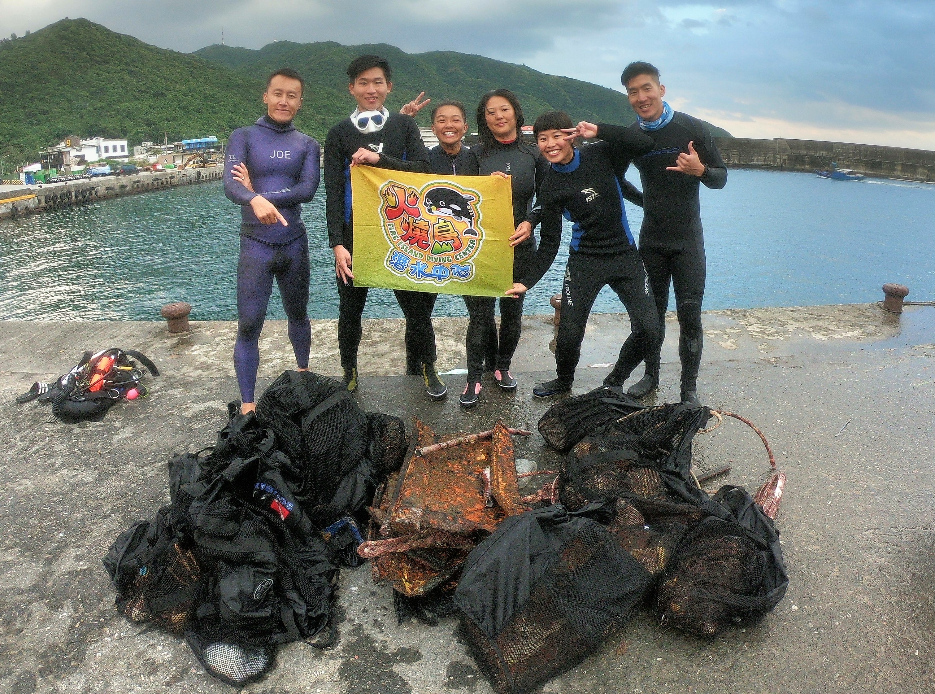
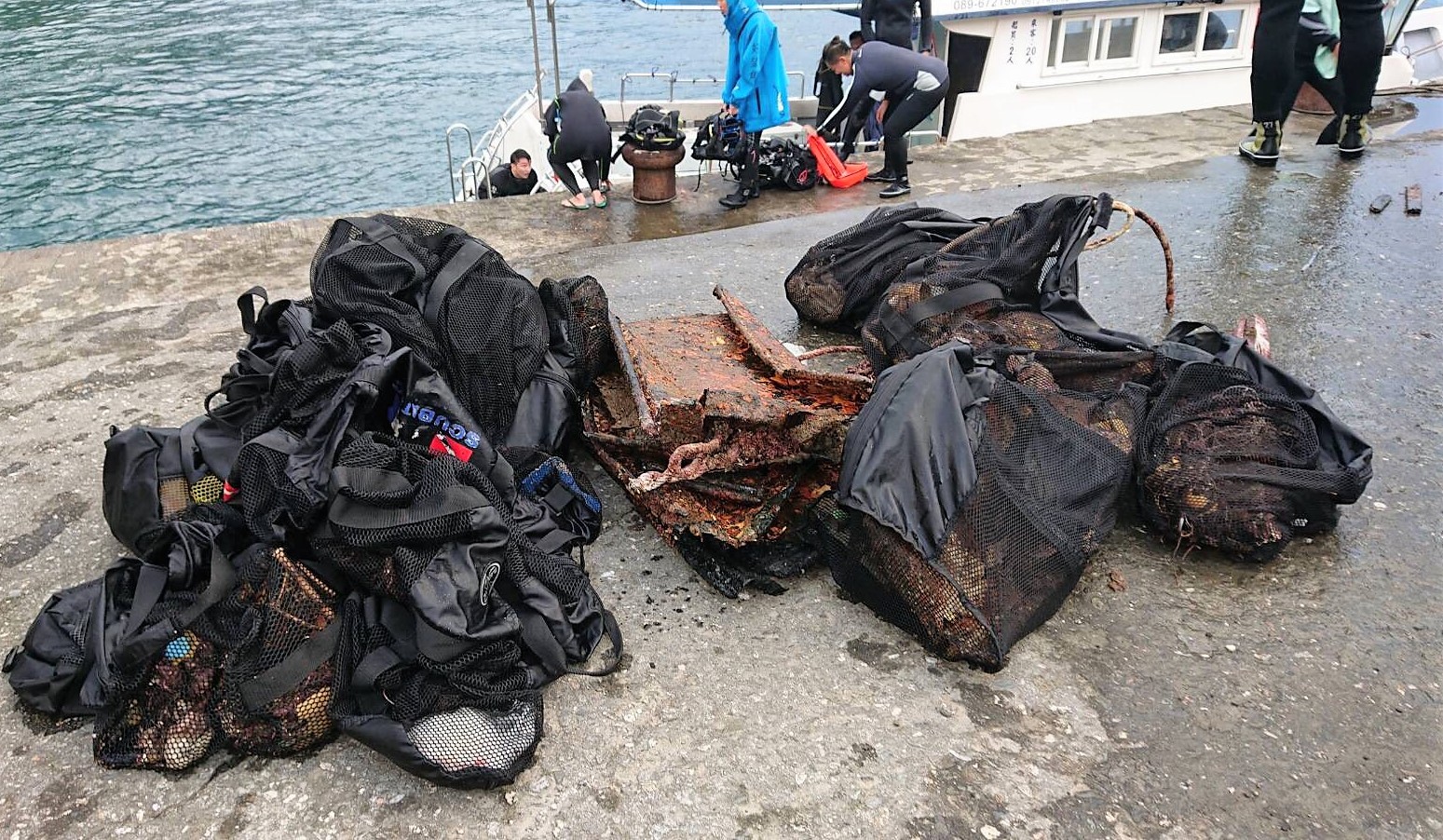
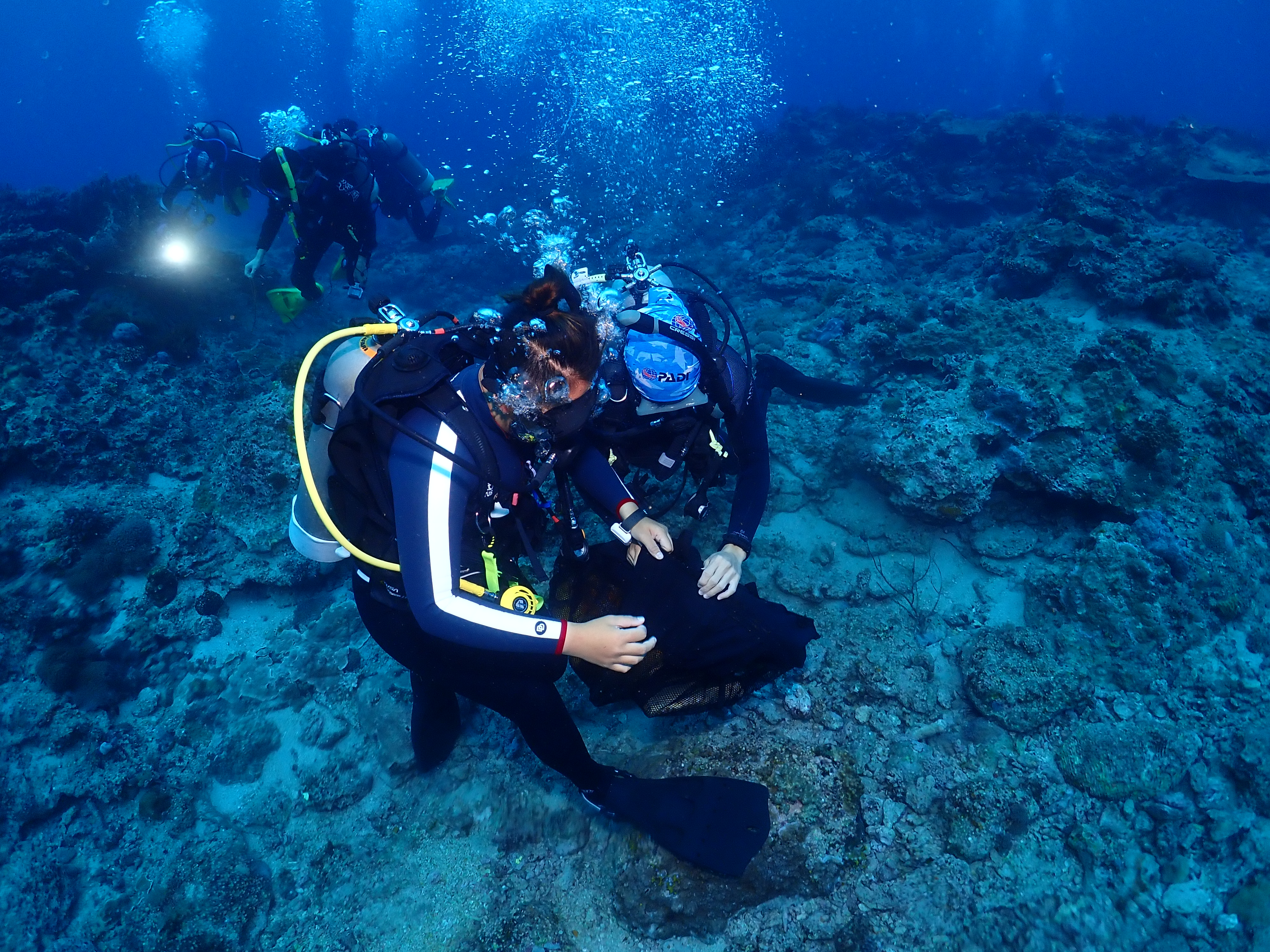
Menu

Salt Pier South

0
0
0
0

12.082946533215, -68.283716131952

0
0
0
sand
0
0
0
0
0
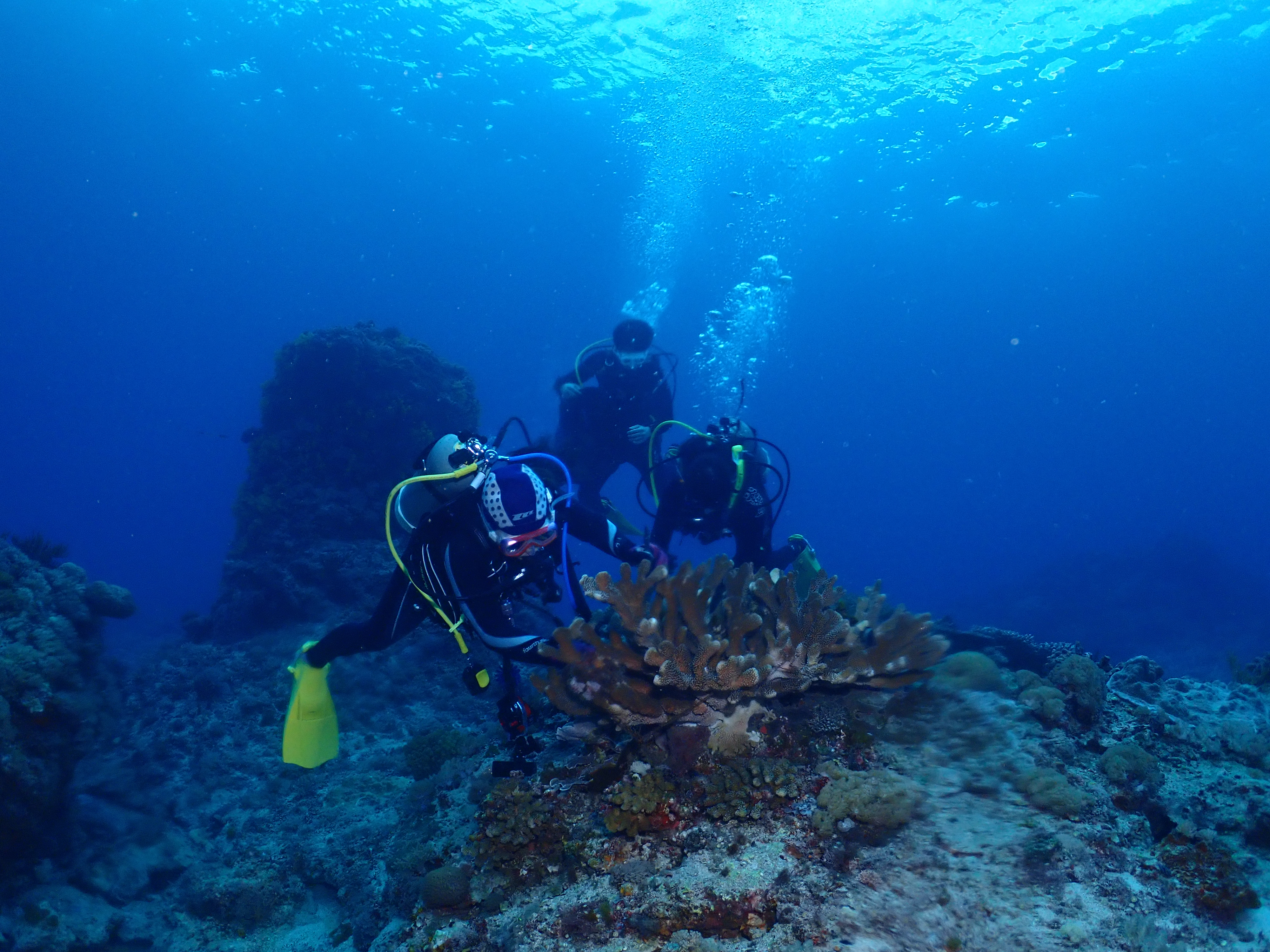
Lots of sea urchins near entry point. Sea turtles seem to frequent this site. Difficult exit.
Wind, probably
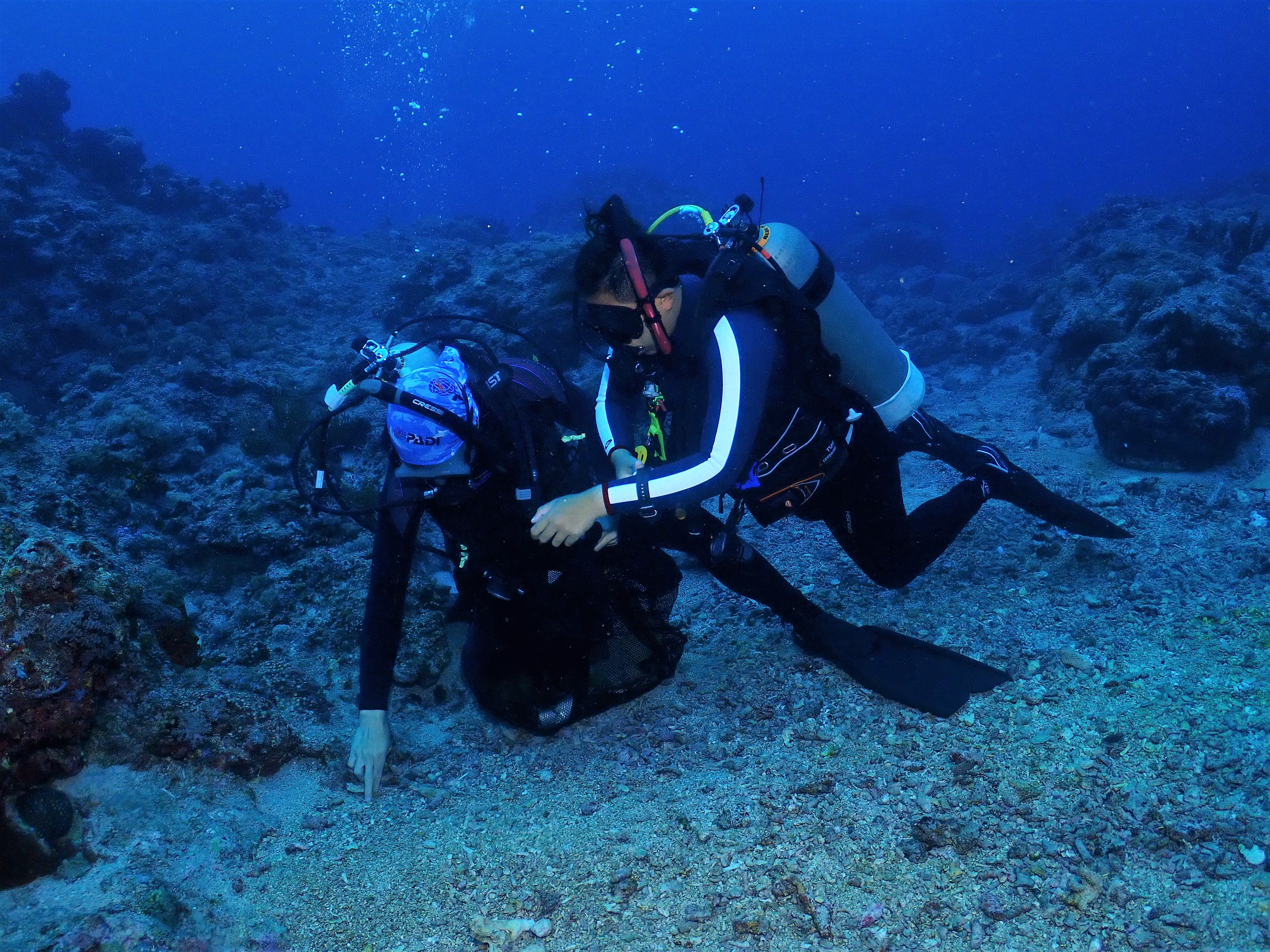
Dive site for Salt Pier South clean except for that one piece. Coral healthy and plenty of wildlife.
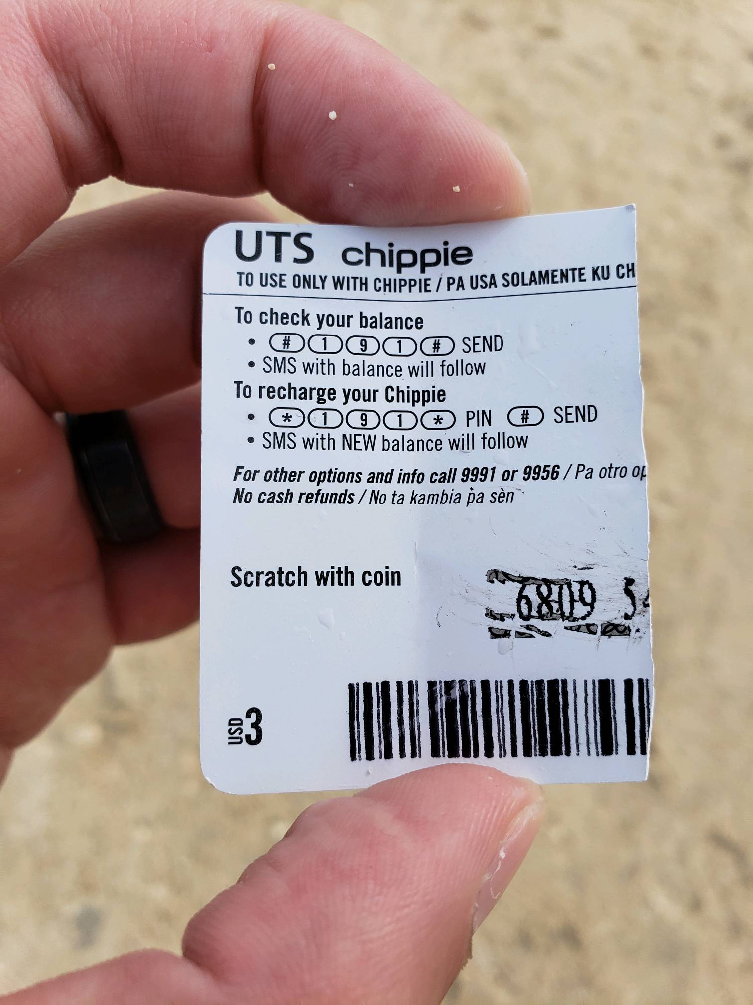
Sim card paper scrap
Sunny, warm
Yuriy Demko
0
0
0
0
0
0
0
0
0
0
0
0
0
0
0
0
0
0
1
2
0
0
0
0
0
0
0
0
0
0
0
0
0
0
0
0
0.01
40
90.00
10.00
0
estimated
0
0
0
0
18336.80
0
0
0
0
0
0
On
pounds
0
I have debris data to report
0
0
0
Smooth (wavelets) for waves 0.1 - 0.5 meter high
0
0
0
0
0
0
0
m2
0
0
feet
coral reef
0
0
0
0
0
0
0
0
0
0
0
0
0
0
0
0
0
0
0
0
0
0
0
0
0
0
0
0
0
Netherlands Antilles
Map Help


Dive Location

If you know your survey site coordinates, enter them manually in decimal degrees using WGS84 Map Datum. Use the minus sign for latitudes south of the equator and longitudes west of the Prime Meridian to 180 degrees.

If you do not know your survey site coordinates, click the “Map Location” tab to use the map to zoom into your survey site and drop the pin on the map to fall within your survey dive site in the water (not on land or the beach). Ensure you zoom in as much as possible to ensure data accuracy.

Entangled Help


Use the vertical tabs below to record any entangled animals you found of each type.

ADS10 - Ørneset

67.225682625869, 14.616451263428

4
rock
12
Saltstraumen DykkeCamp
Fredric Ihrsen
1
1
1.80
55
21.00
1.00
measured
32
3000.00
On
kilograms
I have debris data to report
Smooth (wavelets) for waves 0.1 - 0.5 meter high m2
meters
kelp
Norway
Map Help


Dive Location

If you know your survey site coordinates, enter them manually in decimal degrees using WGS84 Map Datum. Use the minus sign for latitudes south of the equator and longitudes west of the Prime Meridian to 180 degrees.

If you do not know your survey site coordinates, click the “Map Location” tab to use the map to zoom into your survey site and drop the pin on the map to fall within your survey dive site in the water (not on land or the beach). Ensure you zoom in as much as possible to ensure data accuracy.

Entangled Help


Use the vertical tabs below to record any entangled animals you found of each type.

ADS116 - Tunnelen

67.23467408813, 14.604692459106

10
rock
15
Saltstraumen DykkeCamp
Fredric Ihrsen
1
1
1.70
51
29.00
5.00
measured
7
2500.00
On
kilograms
I have debris data to report
Smooth (wavelets) for waves 0.1 - 0.5 meter high m2
meters
kelp
Norway
Map Help


Dive Location

If you know your survey site coordinates, enter them manually in decimal degrees using WGS84 Map Datum. Use the minus sign for latitudes south of the equator and longitudes west of the Prime Meridian to 180 degrees.

If you do not know your survey site coordinates, click the “Map Location” tab to use the map to zoom into your survey site and drop the pin on the map to fall within your survey dive site in the water (not on land or the beach). Ensure you zoom in as much as possible to ensure data accuracy.

Entangled Help


Use the vertical tabs below to record any entangled animals you found of each type.

ADS518 - Batu Bolong

-8.536846, 119.614061

coral
2
1
Calm weather, strong current
Azul Unlimited
Sarah Miller
8
2
1
1.00
55
25.00
5.00
estimated
50.00
plastic bags
plastic single use cups
On
kilograms
I have debris data to report
Smooth (wavelets) for waves 0.1 - 0.5 meter high m2
meters
rocky reef
Indonesia
State\Province
NTT
City
Labuan Bajo
Map Help


Dive Location

If you know your survey site coordinates, enter them manually in decimal degrees using WGS84 Map Datum. Use the minus sign for latitudes south of the equator and longitudes west of the Prime Meridian to 180 degrees.

If you do not know your survey site coordinates, click the “Map Location” tab to use the map to zoom into your survey site and drop the pin on the map to fall within your survey dive site in the water (not on land or the beach). Ensure you zoom in as much as possible to ensure data accuracy.

Entangled Help


Use the vertical tabs below to record any entangled animals you found of each type.

Koh Talu

0
0
0
0

7.950386, 98.793368

0
0
0
coral
0
1
0
0
0
There are more trash to collect for sure.
No
Dive almost everyday these sites so will collect more.
Propeller
Rainy and windy
Dive With A Finn
Samuel Sjöstrand
0
0
0
0
0
0
0
0
0
0
0
0
0
0
0
0
0
0
0
3
0
0
0
0
0
0
1
0
0
0
0
0
0
0
0
0
3.00
55
17.00
3.00
0
estimated
0
0
0
1
1679.90
0
0
0
0
0
Plastic
Fishing lures
0
On
kilograms
0
I have debris data to report
0
0
0
Slight for waves 0.5 -1.25 meter high
0
0
0
0
0
0
0
m2
0
0
meters
coral reef
1
0
0
0
0
0
0
0
0
0
0
0
0
0
0
0
1
0
0
0
0
0
0
0
0
0
0
0
0
Thailand
State\Province
Krabi
City
Ao Nang
Map Help


Dive Location

If you know your survey site coordinates, enter them manually in decimal degrees using WGS84 Map Datum. Use the minus sign for latitudes south of the equator and longitudes west of the Prime Meridian to 180 degrees.

If you do not know your survey site coordinates, click the “Map Location” tab to use the map to zoom into your survey site and drop the pin on the map to fall within your survey dive site in the water (not on land or the beach). Ensure you zoom in as much as possible to ensure data accuracy.

Entangled Help


Use the vertical tabs below to record any entangled animals you found of each type.

ADS584 - Holyrood Marina

1

47.389297, -53.126558

silt
Benjamin L is a 12 YO diver who certified in Mexico this past April. He has four logged dives. His family is presently visiting Newfoundland. Ben thought a jump in the "cool" waters of Conception Bay was in order. He booked a DLD with Ocean Quest Adventures. Given his experience and depth restrictions he was unable to dive the Bell Island Shipwrecks. We kind of ruined his plans. Not one to disappoint a keen new diver we offered a "treasure hunt." Dive one: getting use to the cold water kit and shaking the rust out. Dive two: Project AWARE Dive Against Debris. Ben was a trooper! Two piece 7MM wetsuit. Did I say Ben was tough? The water temp at depth was 1 degree C or almost 34 degrees F. He bagged most of the debris. Some of the "stubby" beverage containers were deposited at this site decades ago. A little cold, a little treasure and a little history. It was a pleasure diving with Ben and introducing this young man to Project AWARE Dive Against Debris.
Breezy, overcast, warm
Ocean Quest Adventures
Mark McGowan
1
1
2
10.00
30
34.00
15.00
2
estimated
300.00
2
Beverage containers (glass and metal) made up > 57% of debris collected.
On
pounds
I have debris data to report
15
Slight for waves 0.5 -1.25 meter high ft2
feet
kelp
1
3
Canada
State\Province
NL
City
Conception Bay South
Map Help


Dive Location

If you know your survey site coordinates, enter them manually in decimal degrees using WGS84 Map Datum. Use the minus sign for latitudes south of the equator and longitudes west of the Prime Meridian to 180 degrees.

If you do not know your survey site coordinates, click the “Map Location” tab to use the map to zoom into your survey site and drop the pin on the map to fall within your survey dive site in the water (not on land or the beach). Ensure you zoom in as much as possible to ensure data accuracy.

Entangled Help


Use the vertical tabs below to record any entangled animals you found of each type.

Green Island Butterfly Reef

6
8
coral

22.661561507596, 121.47171362585

NO
not know
NO
Reinforcement
Sunny, no rain
fire island dive resort
chiu i feng
3
2
4
6
9
33
105.00
47
14.00
3.00
4
estimated
6
30.00
0
Drink bottle
Iron sheets
Furniture wood
On
kilograms
I have debris data to report
6
1
4
Smooth (wavelets) for waves 0.1 - 0.5 meter high
4
m2
5
meters
coral reef
3
8
3
2
2
13
Taiwan
State\Province
taiwan
City
Taitung
Map Help


Dive Location

If you know your survey site coordinates, enter them manually in decimal degrees using WGS84 Map Datum. Use the minus sign for latitudes south of the equator and longitudes west of the Prime Meridian to 180 degrees.

If you do not know your survey site coordinates, click the “Map Location” tab to use the map to zoom into your survey site and drop the pin on the map to fall within your survey dive site in the water (not on land or the beach). Ensure you zoom in as much as possible to ensure data accuracy.

Entangled Help


Use the vertical tabs below to record any entangled animals you found of each type.

Basalt Island, Hong Kong SAR

4

22.309834384086, 114.36505361568

1
rock
1
3

22.309834384086, 114.36505361568

no
Sunny
Environmental Protection Department of HKSAR
LEUNG Kwok-wing
2
1
17
2
1.16
40
20.00
1.00
1
measured
15000.00
On
kilograms
Our Survey Site was free of debris
Smooth (wavelets) for waves 0.1 - 0.5 meter high m2
meters
rocky reef
2
Hong Kong S.A.R., China
State\Province
Guang Dong
City
Hong Kong
Map Help


Dive Location

If you know your survey site coordinates, enter them manually in decimal degrees using WGS84 Map Datum. Use the minus sign for latitudes south of the equator and longitudes west of the Prime Meridian to 180 degrees.

If you do not know your survey site coordinates, click the “Map Location” tab to use the map to zoom into your survey site and drop the pin on the map to fall within your survey dive site in the water (not on land or the beach). Ensure you zoom in as much as possible to ensure data accuracy.

Entangled Help


Use the vertical tabs below to record any entangled animals you found of each type.

The Waterfall

0
0
0

10.091602641655, 99.838316698477

0
0
0
coral
0
0
0
0
0
Boats coming to get fresh water and throwing their rubbish overboard
Big umbrella
Sunny and hot
0
0
0
0
0
0
0
0
0
0
0
0
0
0
0
0
0
0
0
0
Koh Exist, Pimp my Dive, Koh Tao Divers.
Caroline Leuba
0
0
0
0
0
0
0
0
0
0
0
0
0
0
0
0
0
0
0
8
0
0
0
0
0
0
0
0
0
0
0
0
0
0
26.00
68
18.00
5.00
0
measured
0
0
30.00
0
0
0
0
0
Discarded fishing nets
Plastic
Rope
0
On
kilograms
0
I have debris data to report
0
0
0
Calm (glassy to rippled) for waves 0 – 0.1 meter high
0
0
0
0
0
0
0
m2
0
0
meters
coral reef
0
0
0
0
0
0
0
0
0
0
0
0
0
0
0
0
0
0
0
0
0
0
0
0
0
0
0
0
Thailand
State\Province
Surat Thani
City
Koh Tao
Map Help


Dive Location

If you know your survey site coordinates, enter them manually in decimal degrees using WGS84 Map Datum. Use the minus sign for latitudes south of the equator and longitudes west of the Prime Meridian to 180 degrees.

If you do not know your survey site coordinates, click the “Map Location” tab to use the map to zoom into your survey site and drop the pin on the map to fall within your survey dive site in the water (not on land or the beach). Ensure you zoom in as much as possible to ensure data accuracy.

Entangled Help


Use the vertical tabs below to record any entangled animals you found of each type.

Taa Cha

0
1
0

10.062661580931, 99.831485020251

0
0
0
rock
0
0
0
0
0
Plastic paddle
Unremarkable
0
0
0
0
0
0
0
0
0
0
0
0
0
0
0
0
0
0
0
0
New Heaven
0
1
0
0
0
0
0
0
0
0
0
0
0
0
0
0
0
0
0
20
0
0
1
0
0
0
0
1
1
0
0
0
0
0
0.00
60
9.00
1.00
0
measured
0
0
80.00
0
0
0
0
0
Plastic bottles <2 litres
Discarded fishing rope
0
On
kilograms
0
I have debris data to report
0
0
0
Smooth (wavelets) for waves 0.1 - 0.5 meter high
0
0
0
NA
Crabs
Injured
2
0
0
0
0
m2
11
0
meters
rocky reef
0
0
0
0
0
0
0
0
0
0
0
0
0
0
0
1
0
0
0
0
0
0
0
0
0
0
0
0
Thailand
State\Province
Surat Thani
City
Koh Tao
Map Help


Dive Location

If you know your survey site coordinates, enter them manually in decimal degrees using WGS84 Map Datum. Use the minus sign for latitudes south of the equator and longitudes west of the Prime Meridian to 180 degrees.

If you do not know your survey site coordinates, click the “Map Location” tab to use the map to zoom into your survey site and drop the pin on the map to fall within your survey dive site in the water (not on land or the beach). Ensure you zoom in as much as possible to ensure data accuracy.

Entangled Help


Use the vertical tabs below to record any entangled animals you found of each type.

Subscribe to