Menu

Racha Noi

0
38
0
3

7.497917, 98.324844

9
0
0
sand
0
7
1
0
0
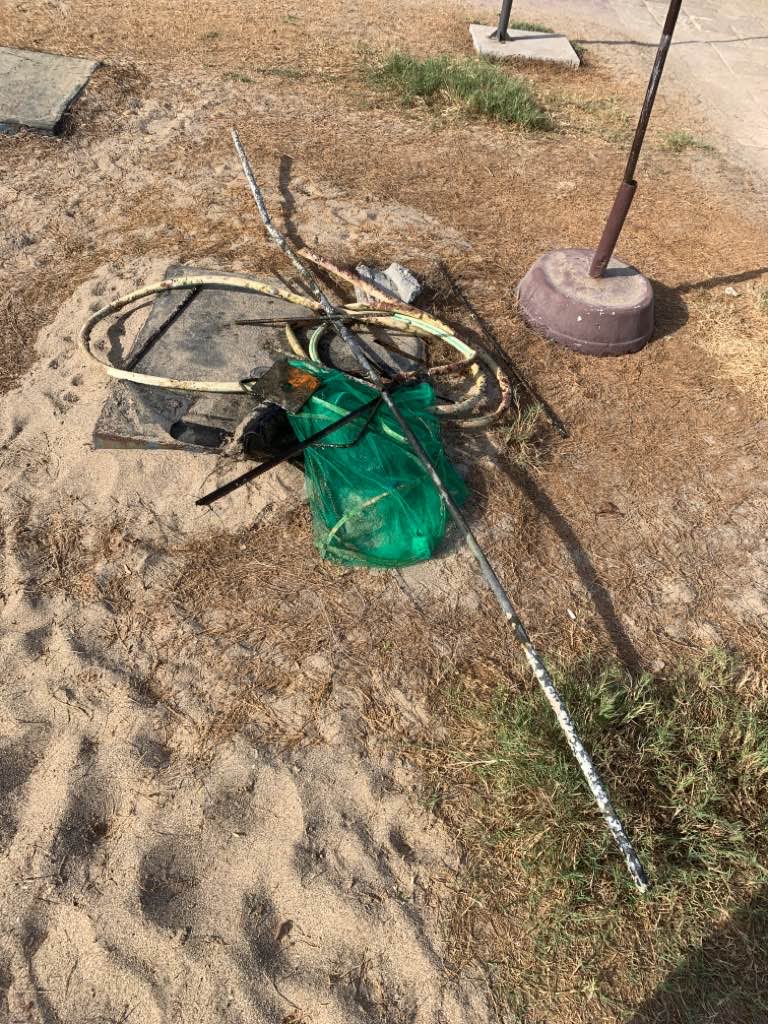
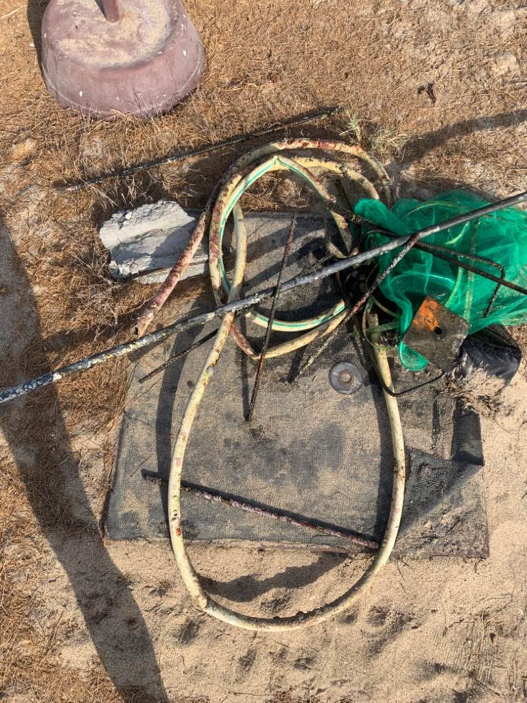
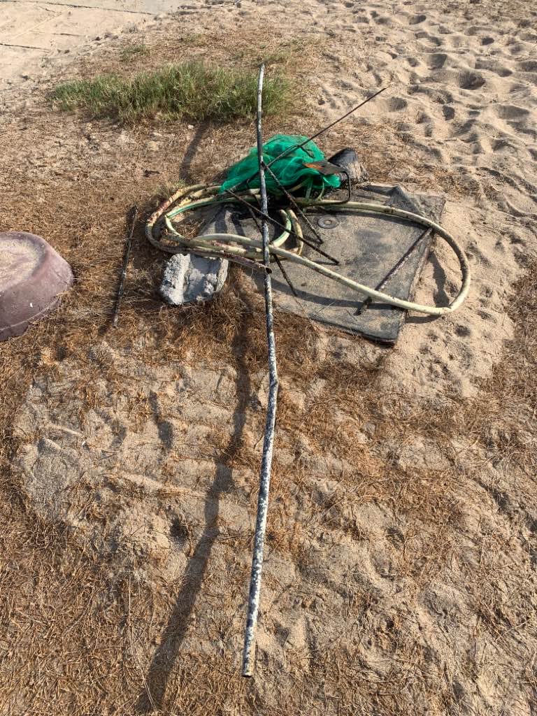
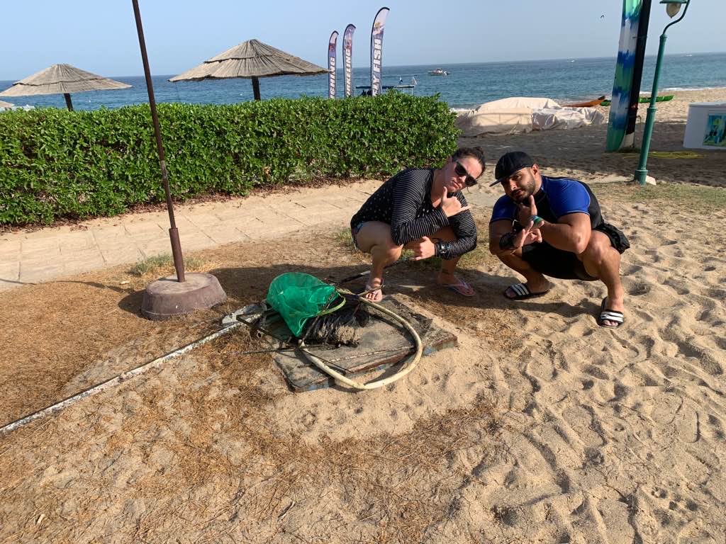
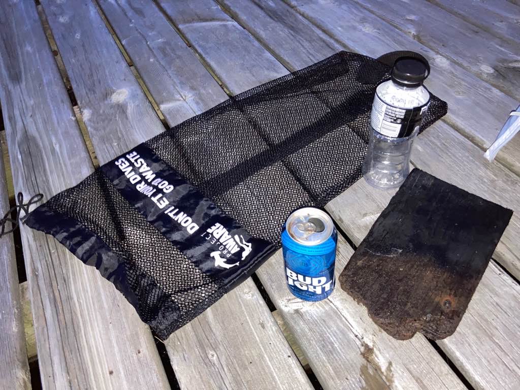
Storm from previous week bringing trash into the reef
Rainy
3
Footwear
Andy's Scuba Diving
Cijin Cherian
0
0
0
0
0
0
0
0
5
0
1
0
0
0
0
0
0
5
0
12
0
0
0
0
0
0
152
0
0
0
0
0
0
0
0
0
15.00
50
12.00
7.00
13
estimated
0
0
0
0
100.00
0
0
0
0
0
Fishing net
0
On
kilograms
0
I have debris data to report
0
0
0
Calm (glassy to rippled) for waves 0 – 0.1 meter high
0
0
0
0
15
0
0
m2
0
0
meters
coral reef
0
0
0
0
0
0
0
0
0
0
0
0
0
0
0
0
0
4
0
0
0
0
0
0
0
0
0
0
0
Thailand
State\Province
Phuket
City
Phuket
Map Help


Dive Location

If you know your survey site coordinates, enter them manually in decimal degrees using WGS84 Map Datum. Use the minus sign for latitudes south of the equator and longitudes west of the Prime Meridian to 180 degrees.

If you do not know your survey site coordinates, click the “Map Location” tab to use the map to zoom into your survey site and drop the pin on the map to fall within your survey dive site in the water (not on land or the beach). Ensure you zoom in as much as possible to ensure data accuracy.

Entangled Help


Use the vertical tabs below to record any entangled animals you found of each type.

ADS566 - Shell Bay

5
10

22.53333, 114.48333

sand
4
A circuit board
Normal
Dive4love
Zhifan Chai
5
8
2
5
15
15.50
45
5.00
2.00
1
measured
3000.00
1
beverage cans
plastic bottles
On
kilograms
I have debris data to report
Slight for waves 0.5 -1.25 meter high
1
6
3
m2
1
meters
rocky reef
3
25
1
China
State\Province
Guangdong
City
Shenzhen
Map Help


Dive Location

If you know your survey site coordinates, enter them manually in decimal degrees using WGS84 Map Datum. Use the minus sign for latitudes south of the equator and longitudes west of the Prime Meridian to 180 degrees.

If you do not know your survey site coordinates, click the “Map Location” tab to use the map to zoom into your survey site and drop the pin on the map to fall within your survey dive site in the water (not on land or the beach). Ensure you zoom in as much as possible to ensure data accuracy.

Entangled Help


Use the vertical tabs below to record any entangled animals you found of each type.

ADS310 - Karangsari

36

-8.706028, 115.5855

coral
15
2 days of rain.
20
Sanitary Pads
Blue Corner Dive and Tamarind Divers
Cody
20
3
8
2
8
1
3.60
60
30.00
5.00
19
measured
50.00
1
Food Packaging (foil lined)
Plastic Fragments
Sanitary Pads
On
kilograms
I have debris data to report
Slight for waves 0.5 -1.25 meter high
1
1
17
m2
meters
coral reef
1
44
Indonesia
State\Province
Bali
City
Jungutbatu
Map Help


Dive Location

If you know your survey site coordinates, enter them manually in decimal degrees using WGS84 Map Datum. Use the minus sign for latitudes south of the equator and longitudes west of the Prime Meridian to 180 degrees.

If you do not know your survey site coordinates, click the “Map Location” tab to use the map to zoom into your survey site and drop the pin on the map to fall within your survey dive site in the water (not on land or the beach). Ensure you zoom in as much as possible to ensure data accuracy.

Entangled Help


Use the vertical tabs below to record any entangled animals you found of each type.

The Canyons

0
0
0

28.00021483902, -16.65708185522

0
0
0
rock
0
0
0
0
0
Rental boats
Tennis ball
Rained
0
0
0
0
0
0
0
0
0
0
0
0
0
0
0
0
0
0
0
0
Paradise Divers
Dan Scarlata
0
0
0
0
0
0
0
0
0
0
0
0
0
0
0
0
0
0
0
5
0
0
0
0
0
0
0
0
0
0
0
0
0
0
1.00
45
22.00
8.00
0
estimated
0
0
1137.92
0
0
0
1
0
Drink cans
Glass fragments
0
On
kilograms
0
I have debris data to report
0
0
0
Slight for waves 0.5 -1.25 meter high
0
0
0
0
0
0
0
m2
0
0
meters
rocky reef
0
0
0
0
0
0
0
0
0
0
0
0
0
0
0
0
1
0
0
0
0
1
0
0
0
0
0
0
Spain
City
Las Galletas
Map Help


Dive Location

If you know your survey site coordinates, enter them manually in decimal degrees using WGS84 Map Datum. Use the minus sign for latitudes south of the equator and longitudes west of the Prime Meridian to 180 degrees.

If you do not know your survey site coordinates, click the “Map Location” tab to use the map to zoom into your survey site and drop the pin on the map to fall within your survey dive site in the water (not on land or the beach). Ensure you zoom in as much as possible to ensure data accuracy.

Entangled Help


Use the vertical tabs below to record any entangled animals you found of each type.

Castelveccana Punta Granelli

2
silt

45.937504667643, 8.6454784870148

sun
Acqua Club Varese
Martina Bogni
2
3.00
47
18.00
5.00
measured
1
1300.00
On
kilograms
I have debris data to report
3
Smooth (wavelets) for waves 0.1 - 0.5 meter high
1
m2
1
meters
other
Italy
State\Province
Varese
City
Castelveccana
Map Help


Dive Location

If you know your survey site coordinates, enter them manually in decimal degrees using WGS84 Map Datum. Use the minus sign for latitudes south of the equator and longitudes west of the Prime Meridian to 180 degrees.

If you do not know your survey site coordinates, click the “Map Location” tab to use the map to zoom into your survey site and drop the pin on the map to fall within your survey dive site in the water (not on land or the beach). Ensure you zoom in as much as possible to ensure data accuracy.

Entangled Help


Use the vertical tabs below to record any entangled animals you found of each type.

Ecosystem Other
Lake

ADS592 - Lady Hole

0
5
0

55.553059383879, -1.6240417410713

0
0
0
silt
0
1
0
0
0
0
0
0
0
0
0
0
0
0
0
0
0
0
0
0
0
0
0
0
0
The Fifth Point
James Learwood
0
0
0
0
0
0
0
0
0
0
0
0
0
0
0
0
0
0
0
11
0
0
0
0
0
0
0
0
0
0
0
0
0
0
0.00
33
7.00
2.00
0
estimated
0
0
9346.76
0
0
0
0
0
0
On
kilograms
0
I have debris data to report
0
0
0
Slight for waves 0.5 -1.25 meter high
0
0
0
0
0
0
0
m2
0
0
meters
rocky reef
0
0
0
0
0
0
0
0
0
0
0
0
0
0
0
0
0
0
0
0
0
0
0
0
0
0
0
0
United Kingdom
State\Province
Northumberland
City
Beadnell
Map Help


Dive Location

If you know your survey site coordinates, enter them manually in decimal degrees using WGS84 Map Datum. Use the minus sign for latitudes south of the equator and longitudes west of the Prime Meridian to 180 degrees.

If you do not know your survey site coordinates, click the “Map Location” tab to use the map to zoom into your survey site and drop the pin on the map to fall within your survey dive site in the water (not on land or the beach). Ensure you zoom in as much as possible to ensure data accuracy.

Entangled Help


Use the vertical tabs below to record any entangled animals you found of each type.

Lake Nagawicka Waukesha County WI USA

0
2
0
0

43.063083, -88.380594

0
2
0
silt
0
0
0
0
0
Calm
Scott Johnson
0
0
0
5
0
0
0
0
0
0
0
0
0
0
0
0
0
1
0
3
0
0
0
0
0
0
0
0
0
0
0
0
1
0
0
0
7.00
60
36.00
20.00
0
measured
0
0
0
0
2237.56
0
0
0
0
0
0
On
pounds
0
I have debris data to report
3
0
0
Calm (glassy to rippled) for waves 0 – 0.1 meter high
0
0
0
0
0
0
0
ft2
0
0
feet
other
0
0
0
0
0
0
0
0
0
0
0
0
0
0
0
0
0
15
0
0
0
0
0
0
0
0
0
0
0
United States
State\Province
WI
City
Delafield
Map Help


Dive Location

If you know your survey site coordinates, enter them manually in decimal degrees using WGS84 Map Datum. Use the minus sign for latitudes south of the equator and longitudes west of the Prime Meridian to 180 degrees.

If you do not know your survey site coordinates, click the “Map Location” tab to use the map to zoom into your survey site and drop the pin on the map to fall within your survey dive site in the water (not on land or the beach). Ensure you zoom in as much as possible to ensure data accuracy.

Entangled Help


Use the vertical tabs below to record any entangled animals you found of each type.

Address hotel port

1
0
0

25.467902895861, 56.365235054599

0
0
0
rock
0
0
0
0
1
Construction site
Measuring tape
Entangled in strapping band
Calm
1
1
0
0
0
0
0
0
0
0
0
0
0
0
0
0
0
0
0
0
Measuring tape
Paint roller
Divers Down UAE
Rose
0
5
0
1
0
0
0
0
0
0
0
0
0
1
0
0
0
1
0
2
0
0
0
0
0
0
0
0
0
0
0
0
0
0
6.00
40
6.00
1.00
0
estimated
0
0
700.00
1
0
0
0
0
Strapping band
Rebar
Hose
0
On
kilograms
0
I have debris data to report
0
0
0
Calm (glassy to rippled) for waves 0 – 0.1 meter high
0
0
0
0
0
0
0
m2
0
0
1
Strapping band
Coral
Dead
meters
rocky reef
0
0
9
0
0
0
0
0
0
0
0
0
0
0
0
0
0
0
0
0
0
0
0
0
0
0
0
0
United Arab Emirates
City
Fujairah
Map Help


Dive Location

If you know your survey site coordinates, enter them manually in decimal degrees using WGS84 Map Datum. Use the minus sign for latitudes south of the equator and longitudes west of the Prime Meridian to 180 degrees.

If you do not know your survey site coordinates, click the “Map Location” tab to use the map to zoom into your survey site and drop the pin on the map to fall within your survey dive site in the water (not on land or the beach). Ensure you zoom in as much as possible to ensure data accuracy.

Entangled Help


Use the vertical tabs below to record any entangled animals you found of each type.

Thai Muang Lake

76

8.357539, 98.265837

sand
2

8.3573343995666, 98.265044275174

This lake is a busy Thai location at weekends, with families coming to swim. While land clean-ups are done weekly, this is the first underwater cleanup to remove trash buildup.
Go2Similan Dive Centre, Khao Lak
Ann Christmas
1
1
25
5
1
6
9
1
2
14.00
60
12.00
1.00
estimated
13849.00
1
Truck tyres x 4 - too heavy to remove.
On
kilograms
I have debris data to report
2
Calm (glassy to rippled) for waves 0 – 0.1 meter high m2
1
meters
other
1
Thailand
State\Province
Phang Nga
City
Takua Pa
Map Help


Dive Location

If you know your survey site coordinates, enter them manually in decimal degrees using WGS84 Map Datum. Use the minus sign for latitudes south of the equator and longitudes west of the Prime Meridian to 180 degrees.

If you do not know your survey site coordinates, click the “Map Location” tab to use the map to zoom into your survey site and drop the pin on the map to fall within your survey dive site in the water (not on land or the beach). Ensure you zoom in as much as possible to ensure data accuracy.

Entangled Help


Use the vertical tabs below to record any entangled animals you found of each type.

Ecosystem Other
Freshwater Quarry (ex tin mine)

ADS407 - Gullivers Lake

0
0
0

43.358694642007, -80.021559721686

0
0
0
silt
0
0
0
0
0
No
Beer can
Clear and Sunny
0
0
0
0
0
0
0
0
0
0
0
0
0
0
0
0
0
0
0
0
Float N Flag
Brad Snyder
0
0
0
0
0
0
0
0
0
0
0
0
0
0
0
0
0
0
0
2
0
0
0
0
0
0
0
0
0
0
0
0
0
0
1.00
45
21.00
9.00
0
estimated
0
0
14461.50
0
0
0
0
0
0
On
kilograms
0
I have debris data to report
2
1
0
Calm (glassy to rippled) for waves 0 – 0.1 meter high
0
0
0
0
0
0
0
m2
0
0
feet
other
0
0
0
0
0
0
0
0
0
0
0
0
0
0
0
0
1
0
0
0
0
0
0
0
0
0
0
0
Canada
State\Province
Ontario
City
Millgrove
Map Help


Dive Location

If you know your survey site coordinates, enter them manually in decimal degrees using WGS84 Map Datum. Use the minus sign for latitudes south of the equator and longitudes west of the Prime Meridian to 180 degrees.

If you do not know your survey site coordinates, click the “Map Location” tab to use the map to zoom into your survey site and drop the pin on the map to fall within your survey dive site in the water (not on land or the beach). Ensure you zoom in as much as possible to ensure data accuracy.

Entangled Help


Use the vertical tabs below to record any entangled animals you found of each type.

Subscribe to