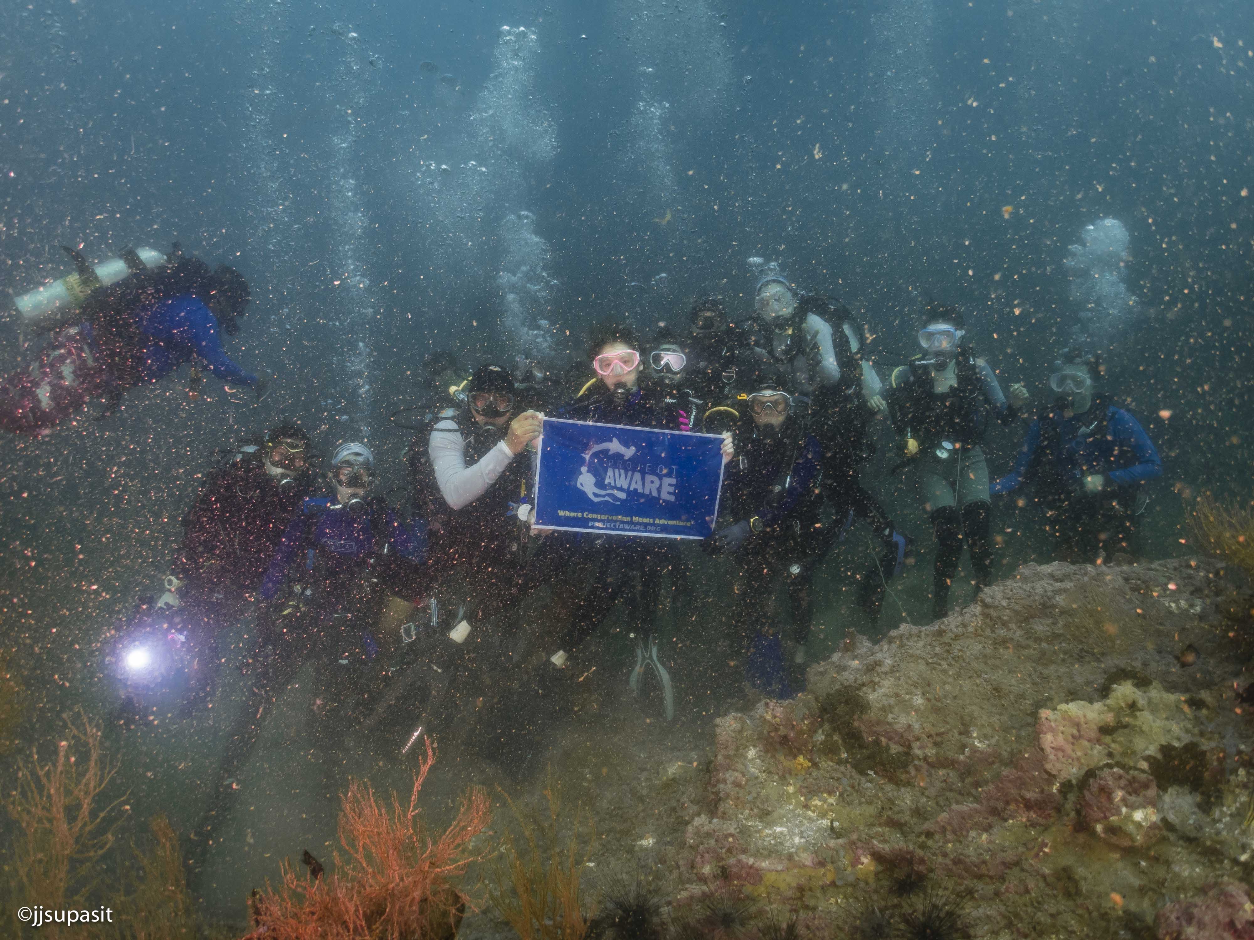
Alhambra Rock is one of our most beloved dive site which attract a lot of diver. Surprisingly, the local authority does not seem to notice this and ignore the facts that a fishermen are destroying this beautiful dive site.
Alhambra Rock is known for school of fish which attract a lot of fisherman. Therefore, the fishing nets are commonly found in the area. Moreover, Alhambra Rock is a pinnacle underwater where has no islands nearby which cause to strong current underwater, and pull a huge fishing net from surround in area into the rock.
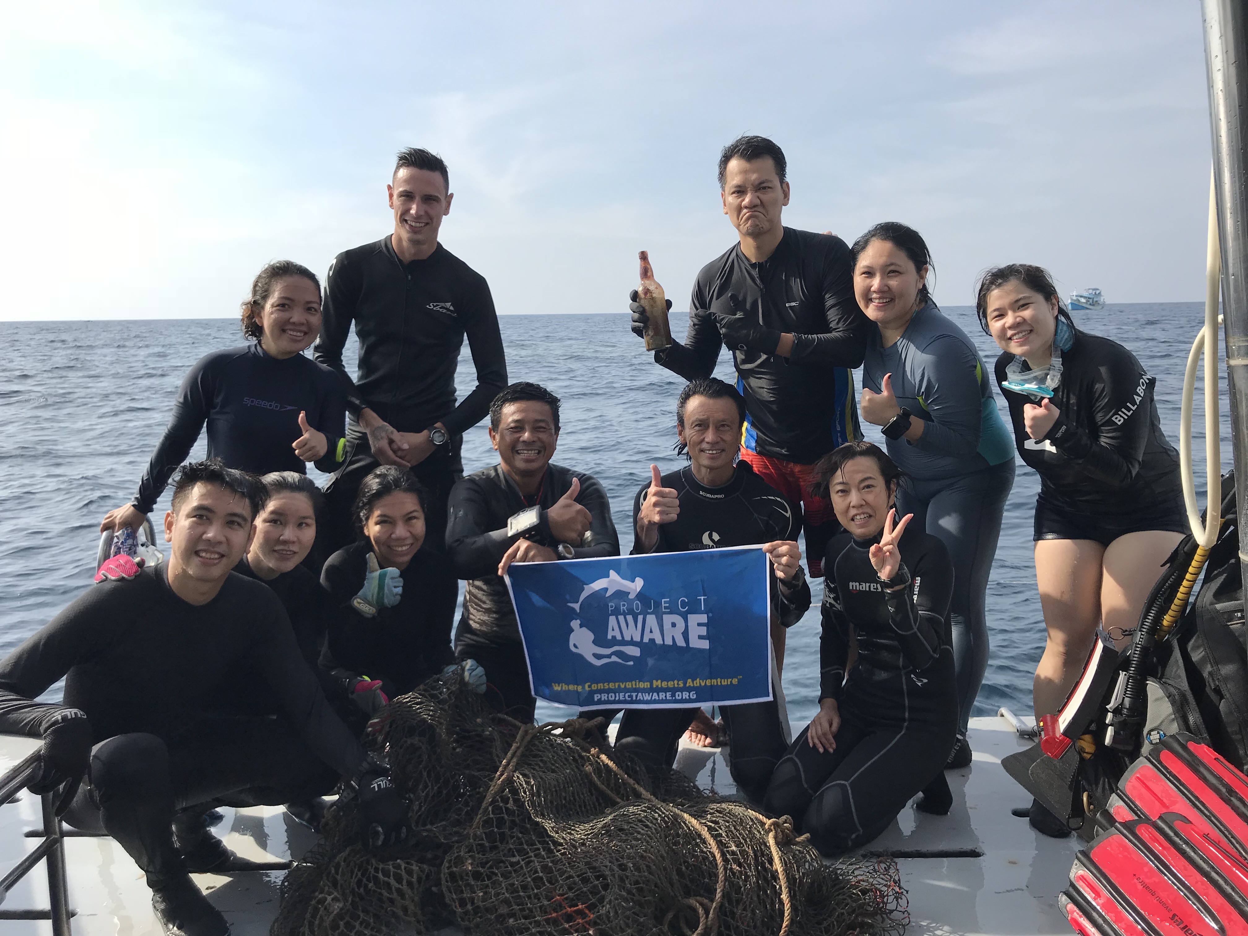
It is an honor being a part of this community since it helps motivate diver to take care of our dive sites and get rid of unwanted items underwater.
A huge fishing net covered on top of the rock which cause a lot of fish to entangled under it.
Fishing equipment
A huge fishing net covered on top of the rock which cause a lot of fish to entangled under it.
The wind was clam for the past week with little to none current. However, the visibility is not as clear the average is around 5 - 10 meters. There were slight rain in the morning but it does not affect the current.
1
Huge Fishing Net
Rayong Dive Center
Phiraphat Boonpetch
5
8
80.00
45
20.00
5.00
estimated
1
3
400.00
1
Fishing net
Fishing Line
Cans and bottle of water
On
kilograms
I have debris data to report
Smooth (wavelets) for waves 0.1 - 0.5 meter high
Huge Fishing Net
Dead
Baracuda, Snapper, Grouper, Fusilier
Coral Crab
Injured
10
30
Huge Fishing Net
m2
meters
rocky reef
10
1
8
Thailand
State\Province
Rayong
City
Klaeng
Map Help
Dive Location
If you know your survey site coordinates, enter them manually in decimal degrees using WGS84 Map Datum. Use the minus sign for latitudes south of the equator and longitudes west of the Prime Meridian to 180 degrees.
If you do not know your survey site coordinates, click the “Map Location” tab to use the map to zoom into your survey site and drop the pin on the map to fall within your survey dive site in the water (not on land or the beach). Ensure you zoom in as much as possible to ensure data accuracy.
Entangled Help
Use the vertical tabs below to record any entangled animals you found of each type.
Calm (glassy to rippled) for waves 0 – 0.1 meter high
2
1
m2
5
meters
coral reef
Language
English
Thailand
State\Province
surat Thani
City
Koh Tao
Map Help
Dive Location
If you know your survey site coordinates, enter them manually in decimal degrees using WGS84 Map Datum. Use the minus sign for latitudes south of the equator and longitudes west of the Prime Meridian to 180 degrees.
If you do not know your survey site coordinates, click the “Map Location” tab to use the map to zoom into your survey site and drop the pin on the map to fall within your survey dive site in the water (not on land or the beach). Ensure you zoom in as much as possible to ensure data accuracy.
Entangled Help
Use the vertical tabs below to record any entangled animals you found of each type.
Calm (glassy to rippled) for waves 0 – 0.1 meter high
20
6
25
24
m2
20
meters
coral reef
2
3
1
Language
English
Thailand
State\Province
Surat Thani
City
Koh Tao
Map Help
Dive Location
If you know your survey site coordinates, enter them manually in decimal degrees using WGS84 Map Datum. Use the minus sign for latitudes south of the equator and longitudes west of the Prime Meridian to 180 degrees.
If you do not know your survey site coordinates, click the “Map Location” tab to use the map to zoom into your survey site and drop the pin on the map to fall within your survey dive site in the water (not on land or the beach). Ensure you zoom in as much as possible to ensure data accuracy.
Entangled Help
Use the vertical tabs below to record any entangled animals you found of each type.
Calm (glassy to rippled) for waves 0 – 0.1 meter high
1
m2
10
meters
coral reef
Language
English
Thailand
State\Province
Surat Thani
City
Koh Tao
Map Help
Dive Location
If you know your survey site coordinates, enter them manually in decimal degrees using WGS84 Map Datum. Use the minus sign for latitudes south of the equator and longitudes west of the Prime Meridian to 180 degrees.
If you do not know your survey site coordinates, click the “Map Location” tab to use the map to zoom into your survey site and drop the pin on the map to fall within your survey dive site in the water (not on land or the beach). Ensure you zoom in as much as possible to ensure data accuracy.
Entangled Help
Use the vertical tabs below to record any entangled animals you found of each type.
Over low season several fisherman entered the bay where fish net and line accumulated and of course clothing that may have flown off the fishing boat.
Football
Raining
1
1
Fan Belt
Football
Assava Dive Resort
Natalie Hunt
2
1
14
5
74
15
3
1
195
3
5
4
2
35.00
60
16.00
5.00
56
measured
200.00
2
Plastic Bottles
Plastic Caps
Fishing line and nets
On
kilograms
1
I have debris data to report
2
Calm (glassy to rippled) for waves 0 – 0.1 meter high
4
1
8
2
4
m2
meters
coral reef
1
4
1
1
4
Language
English
Thailand
State\Province
Surat Thani
City
Koh Tao
Map Help
Dive Location
If you know your survey site coordinates, enter them manually in decimal degrees using WGS84 Map Datum. Use the minus sign for latitudes south of the equator and longitudes west of the Prime Meridian to 180 degrees.
If you do not know your survey site coordinates, click the “Map Location” tab to use the map to zoom into your survey site and drop the pin on the map to fall within your survey dive site in the water (not on land or the beach). Ensure you zoom in as much as possible to ensure data accuracy.
Entangled Help
Use the vertical tabs below to record any entangled animals you found of each type.
Calm (glassy to rippled) for waves 0 – 0.1 meter high
1
m2
meters
other
1
8
Language
English
Canada
Map Help
Dive Location
If you know your survey site coordinates, enter them manually in decimal degrees using WGS84 Map Datum. Use the minus sign for latitudes south of the equator and longitudes west of the Prime Meridian to 180 degrees.
If you do not know your survey site coordinates, click the “Map Location” tab to use the map to zoom into your survey site and drop the pin on the map to fall within your survey dive site in the water (not on land or the beach). Ensure you zoom in as much as possible to ensure data accuracy.
Entangled Help
Use the vertical tabs below to record any entangled animals you found of each type.
Calm (glassy to rippled) for waves 0 – 0.1 meter high
1
m2
meters
other
10
Language
English
Canada
Map Help
Dive Location
If you know your survey site coordinates, enter them manually in decimal degrees using WGS84 Map Datum. Use the minus sign for latitudes south of the equator and longitudes west of the Prime Meridian to 180 degrees.
If you do not know your survey site coordinates, click the “Map Location” tab to use the map to zoom into your survey site and drop the pin on the map to fall within your survey dive site in the water (not on land or the beach). Ensure you zoom in as much as possible to ensure data accuracy.
Entangled Help
Use the vertical tabs below to record any entangled animals you found of each type.
Proximity to the beach and some runoffs from shore
corner of a plastic table with leg
Mostly sunny, one day with bigger waves
Divecenter Merlin
Christian Harder
1
36
2
2
1
16
12.00
70
7.50
3.00
1
estimated
6000.00
8
1
Plastic bottles
Cans
Food wrappers
6
On
pounds
I have debris data to report
2
Calm (glassy to rippled) for waves 0 – 0.1 meter high
1
20
m2
1
meters
rocky reef
2
11
1
Language
English
Dominican Republic
State\Province
Puerto Plata
City
Sosua
Map Help
Dive Location
If you know your survey site coordinates, enter them manually in decimal degrees using WGS84 Map Datum. Use the minus sign for latitudes south of the equator and longitudes west of the Prime Meridian to 180 degrees.
If you do not know your survey site coordinates, click the “Map Location” tab to use the map to zoom into your survey site and drop the pin on the map to fall within your survey dive site in the water (not on land or the beach). Ensure you zoom in as much as possible to ensure data accuracy.
Entangled Help
Use the vertical tabs below to record any entangled animals you found of each type.
Calm (glassy to rippled) for waves 0 – 0.1 meter high
ft2
feet
rocky reef
Language
English
United States
State\Province
FL
City
Islamorada
Map Help
Dive Location
If you know your survey site coordinates, enter them manually in decimal degrees using WGS84 Map Datum. Use the minus sign for latitudes south of the equator and longitudes west of the Prime Meridian to 180 degrees.
If you do not know your survey site coordinates, click the “Map Location” tab to use the map to zoom into your survey site and drop the pin on the map to fall within your survey dive site in the water (not on land or the beach). Ensure you zoom in as much as possible to ensure data accuracy.
Entangled Help
Use the vertical tabs below to record any entangled animals you found of each type.
Smooth (wavelets) for waves 0.1 - 0.5 meter high
ft2
feet
other
Language
English
United States
State\Province
FL
City
Islamorada
Map Help
Dive Location
If you know your survey site coordinates, enter them manually in decimal degrees using WGS84 Map Datum. Use the minus sign for latitudes south of the equator and longitudes west of the Prime Meridian to 180 degrees.
If you do not know your survey site coordinates, click the “Map Location” tab to use the map to zoom into your survey site and drop the pin on the map to fall within your survey dive site in the water (not on land or the beach). Ensure you zoom in as much as possible to ensure data accuracy.
Entangled Help
Use the vertical tabs below to record any entangled animals you found of each type.