
Dive Against Debris Data Submission
Y-73 Wreck, Charleston, SC
20 September, 2015
- Team Leader
- Michelle Taliercio
- Number of Participants
- 11
- Total Debris Collected
- 7 lbs (estimated)
32.178401, -79.786231
Survey Information
- Location Name
- Y-73 Wreck, Charleston, SC
- Organization/Dive Centre
- Charleston Scuba
- City
- Charleston
- Country
- United States
- Date
- 20 September, 2015
- Survey Duration
- 80 Minutes
- GPS Coordinates
- Latitude: 32.178401
Longitude: -79.786231
- Weather Conditions
-
Seas started out 4-5 ft, NE wind 5-10 Knots, settled down to 3 ft seas, E wind at 5 knots
- Survey Depth Range
- 65–100 feet
- Area Surveyed
- 8100 ft2
- Dominant Substrate
- 190 ft oil tanker
- Ecosystem
- coral reef
- Wave Conditions
- Moderate to rough for waves greater than 1.25 meters
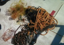
Survey Photos

Debris Items Collected
| plastic materials collected | |
|---|---|
| Bags-grocery/retail (plastic) | 2 |
| Fishing: Line | 300 |
| Fishing: Lures, Rods/poles | 20 |
| SCUBA & Snorkel Gear-masks, Snorkels, Fins | 2 |
| Rope (plastic/nylon) | 250 |
| metal materials collected | |
|---|---|
| Forks, Knives, Spoons (cutlery) | 1 |
| Fishing: Sinkers, Lures, Hooks | 11 |
Additional Information
This is a heavily fished wreck, always lots of line and hooks on the wreck making it dangerous for divers to penetrate at times.
A knife a diver lost months earlier on the site
fishing line
anchors
anchor line
Comments and Feedback
I want to thank everyone for their efforts during our 5th Annual Ocean Clean up. Couldn't have done it with out you


